Note: Descriptions are shown in the official language in which they were submitted.
CA 02589820 2007-05-24
SUBTERRANEAN POSITIONING SYSTEM FOR MONITORING
MOVEMENT UNDERGROUND AND METHOD
Field of the Invention
This invention relates to monitoring and positioning systems. In particular,
this invention relates to a monitoring and positioning system particularly
suitable for
monitoring subterranean motion.
Background of the Invention
Block cave mining is a method of mining that is gaining popularity, despite
the fact that it has been in use for some years. One of the factors that
hinders the
advancement of block cave mining technology, however, is that it is difficult
to
determine what is happening inside the rock mass during the mining process.
Some
theories state that comminution may occur within the rock mass, although there
continues to be little known about the rock dynamics with any degree of
certainty.
A precise understanding of the actual flow of the ore body during the
mining process would be advantageous, to ensure that current practices and
knowledge about the block cave mining method are as efficient and complete as
possible and to ensure that beneficial changes to operating techniques can be
developed. More specifically, the ore body dynamics are important for a
determination
of the number of draw points required during mining, determination of the
exact
location of the cave front on a daily basis, the potential to alter tipping
practices to use
the contained energy in the ore body for enhanced comminution, and the safety
of the
miners based on knowledge of the cave front location and behaviour.
A better understanding of the ore body flow would be beneficial to a
number of aspects of the mining process. For instance, it would be possible to
develop
a trapped miner rescue system based on the data through the use of an
"Underground
Positioning System" or UPS. This infonnation would also be useful for the
development of active mining control tools to control mining equipment. In
addition,
mine-wide asset management systems could be developed in order to improve
efficiency of mining operations.
-1-
CA 02589820 2007-05-24
Several attempts have been made to determine what is occurring within the
rock mass during the mining process. Generally, these attempts have taken the
form of
either markers or computer simulations.
Markers have been injected into the rock mass to try to determine the
material flow characteristics. The markers have typically been made of steel
and
injected into the rock mass above the ore body. As the ore body starts to
fracture,
these markers begin to travel through to the rock mass to the draw bells
below. These
markers are collected and matched to entrance location and exit location. It
is then
assumed that the route of travel is a straight line between the two points
representing
the trajectory and thus the flow of the rock mass. Although some success has
been
achieved using this technique, the number and validity of assumptions
underlying the
technique and the lack of data due to loss of markers has resulted in limited
effectiveness.
Computer software has also been used to simulate the flow of rock and
several different simulation software systems exist. Some represent the rock
as
spheres while others use more rock-like shapes. The results of the computer
simulations suggest that spherical rocks may be less able to represent reality
than more
realistic shapes. However, both of these methods suffer from a lack of
empirical data
and are of limited use.
There is no comprehensive measurement data from within the rock mass,
or any other fluid mass, to gather real time information about the dynamics of
the
mass movement. In many cases, for example in mining, this is generally due to
the
physical constraints of entering the ore body with active sensing systems. For
instance,
sensors must be built so as to survive within the ore body, despite the high
pressure
and flow constraints. The sensing system must be robust enough to allow
positioning
within the ore body with sufficient accuracy that assumptions can be
minimized. Such
sensors must have a power system capable of lasting long periods of time while
in the
rock mass. The transmission system used must be capable of penetrating
substantial
thicknesses of rock of varying density in order to transmit and receive from
the
sensors. Finally, an interface must be available for real time data analysis
in order for
-2-
CA 02589820 2007-05-24
the technical and operating personnel in the subsurface to determine
information about
the cave front.
Brief Description of the Drawings
In drawings that illustrate by way of example only a preferred embodiment
of the invention,
Figure 1 is a schematic diagram of a basic subterranean positioning system
according to the invention utilizing a combination of radio frequencies that
are
medium penetrating radio and acoustic transmissions.
Figure 2 is a schematic diagram of an Underground Positioning System
(UPS) element suitable for the system of Figure 1.
Figure 3 is a schematic diagram of a triangulation system using a
probabilistic function for determining time of flight.
Figure 4 is a schematic diagram of the subterranean positioning system of
Figure 1 showing initial movement of a UPS element.
Figures 5A to 5E are schematic diagrams of the subterranean positioning
system of Figure 1 showing transmission from the radio frequency antennae to
the
UPS elements from various positions.
Figures 6A to 6C are schematic diagrams of the subterranean positioning
system of Figure 1 showing transmission from the acoustic transmitters to the
UPS
elements from various positions.
Figure 7 is a schematic diagram of the subterranean positioning system of
Figure 1 showing transmission from the UPS elements to the radio frequency and
acoustic antennae.
Figure 8 is a schematic diagram of a further embodiment of a UPS element
without an atomic clock.
-3-
CA 02589820 2007-05-24
Figure 9 is a schematic diagram of a further embodiment of the
subterranean positioning system showing an embodiment of the antennae with
radio
frequencies that are medium penetrating.
Figures l0A to l0E are schematic diagrams of the subterranean positioning
system of Figure 9 showing transmission from the acoustic transmitters to the
UPS
elements from various positions.
Figure 11 is a schematic diagram of the subterranean positioning system of
Figure 9 showing transmission from the UPS elements to the antennae with radio
frequencies that are medium penetrating.
Figure 12 is a schematic diagram of a further embodiment of a UPS
element without a microphone.
Detailed Description of the Invention
The present invention provides a subterranean positioning system, a
preferred embodiment of which is illustrated in Figure 1, and method, which is
adaptable to virtually any fluid mass but is particularly suitable for use in
block cave
mining. The system and method of the invention will be described in the
context of
block cave mining, but it has applications in other environments and the
description is
not intended to be limiting in this regard. For instance, the system and
method of the
invention has application in most types of fluid materials, such as in mass
movement
in a fluid-plastic or viscous state, including mass creep, mass falls, mass
slides, mass
topples, or mass flows. This may include, by way of non-limiting example,
movement
of the soil, regolith, and rock by the force of gravity; mass movement
resulting from
slope failure, excavation or erosion; land slides; debris slides; debris
flows; sand
slides; sand flows; rock slides; rock flows; mud slides; mud flows; mud
streams or
lahars; soil, sediment or colluvium shifts, slides, or flows; riverbed
movement;
avalanches of snow, ice, rock or soil; ice flows; glacier flows; landfill,
garbage,
recycled goods or waste shifts or flows; human-made material flows; waste-
water
flow; or water flow.
-4-
CA 02589820 2007-05-24
The present invention provides a position monitoring system for monitoring
motion in a fluid material, comprising a plurality of underground positioning
system
(UPS) elements for embedding within the fluid material, each UPS element
comprising at least a signal transmitter for transmitting a characteristic emf
signal
having an identifier for associating the signal with the transmitting UPS
element; a
first antenna coupled to a first signal receiver and positioned for receiving
the
characteristic signals from the UPS elements and transmitting the
characteristic
signals to a data processing apparatus; and at least a second antenna coupled
to the
first signal receiver or another signal receiver and positioned for receiving
the
characteristic signals from the UPS elements and transmitting the
characteristic
signals to the data processing apparatus; whereby a data processing apparatus
receiving the signals from the first and second antennae corresponding to the
characteristic signals from the UPS elements determines a location of each
transmitting UPS element associated with each characteristic signal as the
fluid
material moves, based on a transmit time at which each characteristic signal
is
transmitted and a receipt time at which each characteristic signal is received
by the
antennae, the characteristic signals transmitted by the UPS elements entrained
in the
moving fluid material thereby providing an indication of at least a direction
or rate, or
both, of the fluid material movement.
The present invention further provides a position monitoring system for
monitoring the motion of a fluid material, comprising: a plurality of UPS
elements in
the fluid material, each UPS element comprising at least a signal transmitter
for
transmitting a characteristic emf signal having an identifier for associating
the signal
with the transmitting UPS element, and a signal receiver for receiving first
antenna
signals from a first antenna having an identifier for associating the first
antenna signal
with the first antenna and second antenna signals from a second antenna having
an
identifier for associating the second antenna signal with the second antenna;
the first
antenna coupled to a signal transmitter and positioned for receiving the
characteristic
signals from the UPS elements and transmitting the first antenna signals to
the UPS
elements; the second antenna coupled to the first signal transmitter or to
another
signal transmitter and positioned for receiving the characteristic signals
from the UPS
-5-
CA 02589820 2007-05-24
elements and transmitting second antenna signals to the UPS elements; and a
data
processing device for receiving signals from the antennae corresponding to the
characteristic signals from the UPS elements and, based on a time each first
antenna
signal is received by the UPS elements relative to a time each second antenna
signal is
received by the UPS elements, determining a location of the UPS element
associated
with each characteristic signal; whereby as the fluid material moves, the
characteristic
signals transmitted by the UPS elements entrained in the moving fluid material
provide an indication of at least a direction or rate, or both, of fluid
material
movement.
The present invention further provides, for use in a position monitoring
system
for monitoring motion in a fluid material, comprising a first antenna coupled
to a first
signal receiver and positioned for receiving characteristic signals from the
UPS
elements and transmitting the characteristic signals to a data processing
apparatus, and
at least a second antenna coupled to the first signal receiver or another
signal receiver
and positioned for receiving the characteristic signals from the UPS elements
and
transmitting the characteristic signals to the data processing apparatus, an
underground positioning system (UPS) element comprising at least: a housing,
and a
signal transmitter contained within the housing, for transmitting a
characteristic emf
signal having an identifier for associating the signal with the UPS element,
and
whereby the data processing apparatas receiving the signals from the first and
second
antennae corresponding to the characteristic signals from the UPS elements
deteimines a location of each UPS element associated with each characteristic
signal
as the fluid material moves, based on a time each characteristic signal is
received by
the antennae, the characteristic signals transmitted by the UPS elements
entrained in
the moving fluid material thereby providing an indication of at least a
direction or
rate, or both, of fluid material movement.
The present invention further provides a method for monitoring motion in a
fluid material, comprising the steps of: (a) locating a plurality of
underground
positioning system (UPS) elements within the fluid material, each UPS element
comprising at least a signal transmitter for transmitting a characteristic emf
signal
having an identifier for associating the characteristic signal with the
transmitting UPS
-6-
CA 02589820 2007-05-24
element; (b) receiving the emf signals from the plurality of UPS elements at a
first
position in communication with the UPS elements, and transmitting data to a
data
processing apparatus corresponding to a time of receiving each emf signal at
the first
position; (c) receiving the emf signals from the plurality of UPS elements at
least at a
second position in communication with the UPS elements, and transmitting data
to the
data processing apparatus corresponding to a time of receiving each emf signal
at the
second position; and (d) processing the data to determine at least a direction
or rate, or
both, of fluid material movement.
According to the invention, a group of UPS elements 10 is inserted into the
rock mass. Each UPS element 10, illustrated schematically in Figure 2, is
preferably
equipped with at least a power source, transmission and receiving capability,
and
positioning instrumentation. The UPS elements of the present invention are
preferably
equipped with a device that has both transmission and receiving capability,
although
the UPS elements may also be equipped with a device that has transmission
capability
coupled to a device that has receiving capability. Although shown
schematically with
a spherical casing 12, the casing may instead be configured irregularly to
mimic the
shape of a rock within the rock mass.
Each of the UPS elements is self-powered, for example by a lithium
battery, and preferably capable of transmitting and/or receiving individual
positional
data on an ongoing basis for a number of years, which may be by means of IP
protocol. In the preferred embodiment, transmission of positional information
occurs
using a radio frequency transmission capable of penetrating the medium, for
example
Very Low Frequency (VLF) radio transmission system. This system may be capable
of
data transmission through rock for distances of up to 2000 metres.
In one embodiment of the present invention, once the rock mass begins to
move, the UPS elements transmit positional data, which is received by at least
two
VLF antennae 20 disposed within communications range of both the current and
expected prospective positions of the rock mass, and preferably three, four or
five
VLF antennae 20 circumscribing the rock mass at different levels as shown in
Figure
9, which transmit the received signals to the base station 50. In this
embodiment, as
-7-
CA 02589820 2007-05-24
well as other possible embodiments of the present invention, UPS elements
(i.e.
capable of signal transmission and receiving) are preferred, but transmitting
elements
(i.e. capable of signal transmission and not signal receiving) can also be
used. All the
antennae may be coupled to signal transmitter (not shown), or each antenna may
be
coupled to its own signal transmitter, for transmitting the received signal to
the base
station 50.
According to the invention, based on the spatial variation between the
intermittent signals transmitted from each UPS element 10, the spatial path
each
element 10 follows over time is determined. Because each UPS element 10 is
housed
in a casing which approximates the shape of a rock in the rock mass, empirical
information about the flow path, rate of flow, and the dynamic characteristics
of the
cave is calculated. The data is plotted on a three-dimensional "Geographic
Information System" or GIS. The system provides empirical data the analysis of
which allows for an understanding of the flow dynamics within the rock mass.
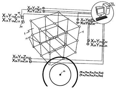
Figure 1 illustrates the basic positioning system used in the method of the
invention, which relies on the principle of triangulation to localize a
receiver to
determine position using XYZ coordinates. Each UPS element 10 intermittently
broadcasts a coded signal, for example a VLF radio signal, including
identifier
information that can be discriminated by the VLF antennae so the particular
UPS
element 10 transmitting the signal is identifiable. A point-to-point
transmission
duration or 'time of flight' for the signal is measured and the position of
the UPS
element 10 is localized as a point on a reference grid 4, representing the
monitored
region 2 containing the group of UPS elements 10.
The position of the UPS element 10 may be determined by Equation E 1::
(x-xi)2 +(Y-Yi)Z +(z-zi)2 =(Rl)2 (El)
i = 1,2,3,4
Equation El can be solved using several methods in order to reduce the
positioning
error of the UPS element 10. The preferred method is to add the delays in the
right
-8-
CA 02589820 2007-05-24
side of the equations and simulate the solutions until the errors are reduced
to a
minimum value.
To improve the accuracy of the system, a mathematical algorithm for
positioning may be employed in order to correct for variation of signal
characteristics
due to travel within the rock mass. The first approach to the mathematical
algorithm is
reference to a specific type of signal, such as an acoustic signal. The
correcting
algorithm can then be extended to any kind of signal, since a general formula
for any
type of known signal can be modeled using the wave equation derived by the
combination of three main properties in physics, namely the conservation of
momentum, the conservation of mass, and the incompressible fluid equation.
The following formulae are provided for an understanding of at least one
manner in which data provided by the invention may be analyzed and utilized.
However, the method of the invention relates to a system for generating the
positional
data, and is not in any way intended to be limited by how the data is
processed or
used.
The general wave equation for acoustic signals is given by:
z
VZS = K 8ts
S(u, t) = So sin(ku - wt) (E2)
p = mass - density
K = Bulk _mod ulus _ elasticity
As preferably four VLF antennae receive positional signals from the UPS
elements 10 in order to precisely determine the position of the rock in the
cave, an
estimate of the position of the rock is to solve the system of equations (E2)
as follows:
(x-xl)Z +(y-yl)2 +(z-zl)Z =(Rl)Z
2x(xi-xl)+2y(yi-yl)+2z(zi-zl)=RIZ -RlZ -(x12 -xiZ)-(y12 -yi2)-(z12 -zi2) (E2)
i~l
This method consists of keeping equation 1 and replacing the others by
subtracting 1 from each of them. This leads to a system of the form AX + BX +
CZ =
-9-
CA 02589820 2007-05-24
D, which is a linear system of equation that can easily be solved. However,
once a
solution is determined, it must verify the first non-linear (or spherical)
equation. This
can be a challenge if the distances Ri are assumed to be constant. The system
may
result in an empty set solution in a pure mathematical form. However, this
assumes
that the distance from each source to the UPS element is a constant, which
would
mean that the time of flight of the signal in the rock environment is known
with
absolute certainty. This is not the case, in general.
Figure 3 illustrates the situation where the time of flight of each signal is
probabilistic. As more sources are added to the system, the zone of
uncertainty
10, shrinks, leading to a better approximation of the position. Equation (E1)
can be
transformed to include the uncertainty zone as follows:
(x - xi)2 + (y - yi)Z + (z - zi)Z = (c,tj)Z
c; = speed _ of _ signal (E3)
t; = probabilistic - time - of _ flight
i = 1,2,3,4
A preferred embodiment of the present invention uses atomic clocks (but is
not limited to) in combination with acoustic cave front analysis. This
embodiment
combines acoustic and very low frequency (VLF) radio transmissions, and has
the
ability to provide very accurate and useful information about the cave front
behaviour.
This design, although more complex than the embodiment described above, has
the
potential to provide higher quality information on rock movement and
composition.
Figure 2 schematically illustrates a first preferred embodiment of the UPS
element 10, for the positioning system of the invention, which consists of an
outer
casing 12 that houses an embedded computer 14 preferably with a triaxial
gyroscope,
which in the preferred embodiment comprises at least one triaxial
accelerometer and
internal strain gauges. The strain gauges, while not part of the location
system, can be
useful for determining the forces acting on the UPS element 10. In addition to
the
sensors, the UPS element 10 preferably also includes a microphone 16 to
receive
coded acoustic signals, and a miniature atomic clock 18 to incorporate waves
that are
emitted and received at the speed of light with less influence from the rock
-10-
CA 02589820 2007-05-24
chara.cteristics. Waves that travel at the speed of light through rock will
likely arrive
more quickly than acoustic waves, because sound waves do not travel as quickly
through rock as radio waves do. Generally, this difference is due to the
presence of
fractures in the rock. For example, when a radio signal and acoustic signal
are sent
simultaneously, once the radio wave (that travelled at the speed of light) and
acoustic
wave arrive at the UPS element, the relative difference in arrival time is an
indication
of the quality of the rock through which the signals passed, i.e. the number
and degree
of fractures. The atomic clock 18 must have very high resolution due to the
close
distances between UPS elements 10 and the fact that VLF radio transmission
takes
place at the speed of light.
To insert the UPS elements 10 into the rock mass within the monitored
region 2 as shown in Figure 1, typically boreholes are drilled from the
surface or a
tunnel above the rock mass. These holes are approximately 6-inches in diameter
and
extend down into the rock to the required depth for the deepest UPS elements
10. The
UPS elements 10 are inserted and grouted into each borehole at a known
elevation.
The UPS elements 10 may be hung on a common power supply line (not shown)
while in the borehole, to keep the batteries in the devices 10 fully charged
until the
rock mass begins to fail. These power lines prolong the battery power and thus
the
useful life of the UPS elements 10. As the ore body begins to break, the power
lines
will disconnect from the UPS elements 10 and the UPS elements 10 will
automatically switch to battery power.
The initial system configuration for this embodiment uses a reference grid
4 that represents the initial drilled locations of the UPS elements within the
monitored
region 2. Each UPS element 10 is embedded in a borehole and the initial
location is
logged in the 3D display software. The infrastructure consists of a base
station
computer 52 that manages VLF communication with the VLF antennae 20.
Communication to and from the UPS elements 10 in this embodiment
occurs via a VLF radio network using a plurality of VLF antennae 20. The VLF
antennae 20 are installed around the ore body in known locations
(Xlv'Yiv'Ziv)'
(X2v,Y2v,Z2v) and (X3v,'Y3v,Z3v)= The acoustic technology in this embodiment
-11-
CA 02589820 2007-05-24
includes a combination of external acoustic transmitters or generators 30 for
positioning and use of the VLF antennae 20. The acoustic transmitters 30 are
installed
around the ore body in known locations (Xi ,e,,Y1A,Zi A), (X2A,Y2A,Z2A) and
(X3A,Y3A,Z3A)= Preferably, each acoustic transmitter 30 is connected to the
base
station 50.
In the operation of this embodiment, the UPS elements 10, acoustic
transmitters 30, and VLF antennae 20 are positioned as described above. As a
UPS
element 10 begins to move, a motion detector inside each UPS element 10 is
activated. Triaxial clinometers, accelerometers, and strain gauges collect the
data from
the UPS element 10 movement. This information provides data about the movement
of the individual UPS element, which is stored in the memory of the UPS
element on-
board computer 14 for transmission to the VLF antennae 20 and then via the VLF
antennae 20 network to the base station 50, where the data is input into the
mathematical equations for resolving. In this embodiment, all atomic clocks
must first
be synchronized to ensure accuracy.
Once movement occurs, a motion detector in the UPS element 10 signals
the UPS element 10 to come out of 'sleep' mode, and after a preset time
interval the
UPS element 10 sends out an initial signal via the VLF transmitter 19 to VLF
antennae 20 and in turn to the base station 50 indicating that the UPS element
10 has
moved to a new location. Figure 4 conceptually illustrates initial movement of
an
individual UPS element 10, at the point of a VLF transmission from UPS element
10
to the VLF antennae 20 (as shown in Figure 7), and from there to the base
station 50,
to signal initial movement of the UPS element 10. The base station computer 52
processes the VLF data received and commands each acoustic transmitter 30 to
send a
signal to the UPS elements 10, as shown in Figures 5A to 5E, measuring the
duration
of travel acoustically. The base station computer 52 similarly commands each
VLF
antenna 20 to send a signal to the UPS elements 10 as shown in Figures 6A to
6C,
measuring the duration of travel which will be at the speed of light.
In another embodiment of the invention, it is not necessary for the UPS
elements 10 to send a signal to indicate initial movement. Instead, the
acoustic
- 12-
CA 02589820 2007-05-24
transmitters 30 send a signal at known intervals, which are received by the
UPS
elements 10. Similarly, the VLF antennae 20 send a signal at known intervals,
which
are received by the UPS elements 10.
In this embodiment, once VLF signal transmission, acoustic signal
transmission and data collection is complete, the base station 50 will
preferably be
sent two data sets. The data sets can be used to derive, among other
information, the
arrival time of the VLF radio waves and the arrival time of the acoustic waves
at the
UPS elements 10. The VLF data will be more immediate while the acoustic will
be
slower, but may provide clues as to the rock characteristics from the on-board
computer 14 in each UPS element 10 to compare and analyze. Figure 7 shows the
transmission of the VLF/atomic clock and the acoustic infonnation data sets
back to
the base station 50 for determination of the mathematical solution.
The transmission of the VLF/atomic clock and the acoustic information
data sets to the base station 50 can be achieved in various ways. For example,
in a
preferred embodiment, each UPS element 10 can be equipped with a repeater
function, and able to receive and relay data sets from neighbouring UPS
elements 10.
This relay matrix can transmit the data sets from one UPS element 10 to
another,
either randomly or in the general direction of the base station 50,
essentially cascading
data signals between UPS elements 10, with the UPS element or elements that
are
closest to the base station 50 finally transmitting the data sets to the base
station 50
directly (or a VLF receiver that can subsequently transmit the data sets to
the base
station). Such a relay matrix would require transmission of signals only over
short
distances (for example, less than 30 metres between UPS elements) allowing the
UPS
elements 10 to conserve power.
In another embodiment of the invention, each UPS element 10 transmits
the data sets to a VLF antenna 20 to be relayed to the base station 50. In yet
another
embodiment of the invention, each UPS element 10 transmits the data sets
directly to
the base station 50.
Each transmission (whether acoustic or VLF radio) is preferably time-
stamped with the instantaneous time setting of the atomic clock 18 of the
transmitting
-13-
CA 02589820 2007-05-24
component at the moment of transmission, and associated with the instantaneous
time
setting of the atomic clock 18 of the receiving component at the moment of
reception.
With this information the base station computer 52 thus calculates, for each
acoustic
signal emitted by the various acoustic transmitters 30, the time elapsed
between
transmission from the acoustic transmitter 30 and reception by the UPS element
10;
and for each VLF radio signal the time elapsed between transmission of the
signal
from the various VLF antennae 20 and reception of the VLF radio signal by each
UPS
element 10. Through triangulation of each data set, an accurate assessment of
instantaneous UPS element 10 positions over a desired time interval, and thus
of rock
movement and location, can be made. The accuracy of path description is a
function
of the number of acoustic transmitters 30 and VLF antennae 20 used. With each
additional acoustic transmitters 30 or VLF antenna 20 used, a better picture
of actual
movement can be calculated.
It will be appreciated that the monitoring system and method of the
invention can be accomplished using only one type of transmission. However,
the
additional information provided by using two different transmission types, in
the
described embodiment for example acoustic and VLF radio transmissions, can
significantly improve the accuracy of the data analysis.
The VLF radio communication travels at much higher speed than the
acoustic signals through the rock. The result of this is a higher degree of
accuracy for
the embodiment of the invention utilizing VLF radio as an atomic clock 18 is
used for
time stamping transmission and reception times. This is referred to as "tight
data,"
while the acoustic data is referred to as "loose data," which does not require
the same
degree of precision time-stamping. For each iteration of the method of the
invention,
there will be a difference between the position estimated by the loose data
and the
tight data, which is analyzed to describe the quality of rock between each
transmission
source located outside the ore body. A larger error (difference between
duration of
travel) indicates that the rock is more fragmented and less competent. The
speed of
VLF radio frequency signal travel is much greater through the rock than
acoustic
signal travel and therefore a greater degree of error is expected from the
acoustic
-14-
CA 02589820 2007-05-24
signals. This larger error, compared with the lower error of the VLF system,
provides
a richer sensing system. This in turn provides a more detailed view of the
cave front.
The result is a conceptual picture of what the caving front composition
might look like at the time of analysis. The process is repeated at intervals,
preferably
daily or weekly for instance, for use in describing the behaviour of an ore
body in this
mining method. This embodiment provides the highest quality and variety of
information.
Another embodiment of the invention uses only acoustic-based devices for
positioning purposes. Figure 8 illustrates a schematic of the UPS element 70
of this
embodiment, which comprises a combination of external acoustic transmitters 30
for
positioning and VLF antennae 20 for communication of time of flight
information to
the base station computer 52 for triangulation. In this embodiment, the UPS
elements
70 may have all the same internal components as the UPS elements 10 of the
previously-described embodiment, except that an atomic clock is not required
in the
UPS elements 70 in this embodiment and instead the relative time of reception
by the
various VLF antennae (which can still provide timing information) and acoustic
receivers is used for triangulation calculations to determine instantaneous
positions of
the UPS elements 70.
In this embodiment, it is possible to use either the VLF antennae 20 as in
the prefen:ed embodiment or a VLF loop antenna 40, more preferably two VLF
loop
antennae 40. The use of VLF loop antennae 40 provides for a large coverage
area for
VLF signal transceiving. Figure 9 shows the initial setup of the VLF loop
antennae 40.
One is located at the surface and one below monitored region. The antenna
located
below the monitored region may be positioned in mine tunnels, for example.
In another embodiment of the invention, instead of VLF loop antennae 40,
VLF ferrite core antennae can be used. When a VLF loop antenna is wrapped
around a
ferrite core, instead of as a continuous loop, this enables transmission of a
VLF radio
signal from a known point since each VLF ferrite core antenna can be placed in
a
predetermined position. The UPS elements 70 are inserted in a drilling grid
formation
as in the embodiment described above.
-15-
CA 02589820 2007-05-24
As a UPS element 70 begins to move, a motion detector (or triaxial gyro)
73 inside the UPS element 70 casing 72 is activated. Triaxial inclinometers
75,
accelerometers 76, and strain gauges 77 collect the data from the movement and
store
it in the memory of the UPS element 70 on-board computer 74 for transmission
via
the VLF antennae 20 to the base station 50 for input into the mathematical
equations
for resolving. Although for each of these features multiple components are
provided
for redundancy, it will be appreciated that only one of each component is
needed to
accomplish its respective function.
While the on-board sensing information is being collected, the motion
detector 73 sends a signal to the on-board computer 74 indicating movement. A
signal
is then relayed via the VLF antennae 20 to the base station 50. The base
station
computer 52 processes the VLF data received and commands each acoustic
transmitter 30 to send the signal to each UPS element 70 to begin acoustic
location of
the UPS element 70. The motion detector 73 and short term storage in the on-
board
computer 74 reduce the amount of time the computers and sensors are powered,
allowing for a'sleep' mode when the UPS element 70 is motionless for a
selected
time period, which in tum reduces power consumption and increases the length
of
time the UPS element 70 is available for data collection.
Figure 10 illustrates measurement of the duration of travel for each signal
from the base station 50 to the UPS element 70. Using a matrix calculation for
'n'
number of signals the location of the UPS element 70 is determined. For
accuracy
verification, different combinations of signal data are used and averaged for
a more
reliable estimate.
Figure 11 illustrates the UPS element 70 transmission times back to base
station 50 for triangulation. To complete the locating process, a signal
containing all
data stored in each UPS element 70 is transmitted to the base station computer
52 for
calculation, data analysis, and if desired, visual representation. This
embodiment can
utilize acoustic transmission technologies similar to those currently used for
VLF
voice communication and microseismic systems. The transmission capability is
variable depending on the rock types and location resolution.
-16-
CA 02589820 2007-05-24
Another embodiment of the invention uses an atomic clock 18 within each
UPS element 80, but does not use acoustic signals, so there is no microphone
necessary in each UPS element 80. Figure 12 illustrates a schematic of the UPS
element 80 of this embodiment.
As movement of the UPS elements 80 of this embodiment begins, motion
detectors awaken the UPS element 80 and the system goes online. The triaxial
clinometers and accelerometers collect the data from the rock movement. The
UPS
element 80 sends out a signal to the base station 50 that it has moved
location.
As the triangulation process begins, all atomic clocks 18 must first be
synchronized to ensure exact accuracy. Less expensive high accuracy clocks may
be
sufficient instead of atomic clocks 18. As the UPS elements 80 transmit time
of travel
via each VLF antennae 20 to the base station for calculation of the UPS
element 80
position. Once all the signals have been received by the UPS element 80 from
the
VLF antennae 20 and stored within each onboard computer, a signal containing
the
collected data is propagated to the base station computer 52 where
calculations are
performed.
The base station computer 52 calculates the time elapsed for each signal to
reach the UPS element 80. Through triangulation, an accurate picture of UPS
element
80 movement and location is obtained. The accuracy of path description and
underground GPS system is a function of the number of VLF antennae 20 used.
With
each additional VLF antenna 20, a better picture of actual movement is
calculated.
This concept has the advantage of being very accurate due to the
transmission being at the speed of light combined with atomic clocks 18. It is
also
robust and has improved survivability. The cost associated with developing the
initial
system is high, however, over the long term this system may be less costly.
A further embodiment of the invention may use gyroscope-based UPS
elements (not shown). In this embodiment, the UPS elements do not need a
microphone or atomic clock. Communication to and from the UPS elements is via
a
-17-
CA 02589820 2007-05-24
VLF radio network with a large loop antenna, preferably two large loop
antennae. For
this embodiment, VLF ferrite core antennae are not necessary.
The initial system configuration of the UPS elements for this embodiment
of the invention is similar to the first embodiment, but without the acoustic
transmitters. As each UPS element moves and translates spatially, the
intenrnal sensing
system of the UPS element begins to work. The accelerometers sense movement
and
the triaxial gyroscopes keep track of small displacements and rotations. This
inforrnation provides individual UPS element x,y,z coordinate data. This
information
is stored in the on-board computer ready for transmission via the VLF radio
network.
As in the previous embodiments, once the UPS element begins to move, it
transmits its location to the loop antennae and ultimately the base station
for display.
Since each UPS element has a VLF transmission system, on-board information can
be
transmitted from the UPS element to the VLF loop antennae. This system is a
one-
way system to download data, which occurs at low speeds, specifically in the
order of
a few baud. A sequence of slow speed communications occurs to download the
position data from the UPS elements to the base station computer for display.
In this
embodiment, the mathematical calculations discussed above are not necessary
since
the instrumentation is on-board each UPS element, so the location is
determined
directly by the on-board sensing system.
As the cave proceeds, several UPS elements move at once. In this
embodiment, each UPS element transmits its data at random times to reduce
collisions
and resulting information loss. This allows a1l the data to be transmitted
slowly, which
is necessary as VLF is a very low capacity system. However, the movement
within the
rock body is expected to be slow, so a slow rate of data transmission is not
problematic.
Even the best gyros drift approximately one degree per hour. To
compensate for gyroscope drift, a re-reference may be required for this method
to
work effectively. The advantages of this embodiment are minimum hardware
requirements and a straight forward workable communication system.
-18-
CA 02589820 2007-05-24
Various embodiments of the present invention having been thus described
in detail by way of example, it will be apparent to those skilled in the art
that
variations and modifications may be made without departing from the invention.
The
invention includes all such variations and modifications as fall within the
scope of the
appended claims.
-19-