Note: Descriptions are shown in the official language in which they were submitted.
CA 02594285 2013-03-27
29719-14
1
Shallow marine electromagnetic hydrocarbon prospecting
= Technical field of the invention
The present invention relates to marine geophysics using electromagnetic
detection
of buried geological formations. In some embodiments, the invention is
particularly
useful for determining whether a prospective petroleum reservoir indicated in
seismics is oil-bearing, and also desirably the horizontal extension of the
petroleum
reservoir, and determining a range for some of the electrical properties of
the
petroleum reservoir. The depth, the extension and particularly the electrical
properties may provide important information about whether a volume of oil in
the
reservoir may be distinguished from ubiquitous pore water that is generally
present in
most porous subterranean rocks.
More specifically, in some embodiments the invention relates to a method for
generating very long-wavelength electromagnetic signals under the sea, and
detecting electromagnetic waves under the sea, some of which waves have
travelled
downward, along and upward through geological layers under the sea, as
indicated in
Fig. la. Such very long-wavelength electromagnetic waves for use in some
embodiments of the present invention are similar to radio waves, but of much
longer
wavelength. Electromagnetic waves are quite severely attenuated in the sea and
in
the ground due to the electrical resistivity of the rocks with more or less
saline water.
The attenuation is most severe for higher frequencies. But given a strong
electromagnetic source and a very sensitive receiver, and using a low
frequency, a
signal having travelled through seawater and the ground may be detected at the
receiver. Generally sedimentary layers may form an overburden over a deeply
buried
porous geological layer being a prospective hydrocarbon reservoir. Some of the
electromagnetic waves have been reflected by the prospective hydrocarbon
reservoir, and some of the waves may have been refracted along the prospective
hydrocarbon reservoir. A small proportion of the reflected or refracted
electromagnetic energy will
CA 02594285 2007-07-03
WO 2006/073315
PCT/N02006/000007
2
reach back to the seafloor in the form of electromagnetic waves, and be
measurable with electromagnetic antennae.
Background of the invention
Several geophysical and direct methods may be used for detecting the
presence of a petroleum reservoir. The methods applied may be used in
different sequences, depending on the amount of knowledge acquired from
previous exploration steps. Magnetometry may be used to determine and
map depths to the bedrock below a sedimentary basin, and is rapidly and
cheaply measured. Gravity measurements may delineate volcanic stocks and
sills that will have a positive gravity anomaly, and salt dome features will
display a negative anomaly in gravity profiles and maps. A petroleum
reservoir may display a negative gravity anomaly due to the fact that the
petroleum fluids are of less density compared to the water that they displace,
but such features are usually not of significant size to be directly detected,
but may constitute a significantly measurable difference during production of
the field. Gravity measurements are also rather rapidly acquired, but rather
more time-consuming as compared to magnetometry.
* Electromagnetic prospecting uses electromagnetic signals of a
wavelength sufficient to penetrate the geological layers under the sea.
Detecting the electromagnetic waves may take place either at the seafloor or
in the sea water. Such electromagnetic prospecting may be used to delineate
some geological layers of higher or lower resistivity than their surrounding
geological formations. A transmitter antenna is used in the sea for
transmitting electromagnetic waves that propagate through the sea and the
geological formations. A small proportion of refracted and reflected
electromagnetic energy will reach back to the seafloor and be detectable.
The detected signals are analysed to indicate petroleum-bearing formations.
Fig. 1a indicates such electromagnetic prospecting.
CA 02594285 2007-07-03
WO 2006/073315
PCT/N02006/000007
3
* Seismic prospecting utilises low-frequency sound waves from a seismic
source, the waves propagating through the sea and the ground to a seismic
receiver. The velocity of seismic waves depend on the density and other
mechanical properties of the rocks they propagate through, and the
propagation mode of the wave, either as a compression or "p"-wave having
the particle motion along the line of seismic energy propagation, or as a
transversal, shear or "s"-wave having its particle motion normal to the line
of
seismic energy propagation. Marine seismics requires a dedicated seismic
source and a highly sensitive array of seismic receivers, usually in the form
of
one or more towed seismic streamers with hydrophones or seabed cables
with hydrophones and geophones, and is a far more time-consuming and
expensive process compared to gravity. Marine seismics may provide high-
resolution reflection seismic profiles that may be processed to show sections
of geological structures indicating potentially petroleum bearing petroleum
traps, like a porous sand formation in an antiform and covered by an
impermeable sedimentary layer, or a porous sand formation vertically offset
by a fault. Such delineated potential petroleum-bearing formations however,
may rarely be distinguished on the basis of their seismic velocities, because
the density and thus the seismic velocity of an oil-bearing formation is only
slightly less than the seismic velocity of the same formation being water-
filled. However, when having found a potential petroleum bearing formation in
the seismic profiles, electromagnetic prospecting may be used to determine
some electrical properties of the formation, indicating the presence of water
or petroleum, as will be described below.
* Drilling is the ultimate and most expensive method to provide geological
information about a prospective reservoir. Based on gravity, electromagnetic
and seismic exploration and general geological information, an evaluation of
the potential field is made. The positions of first exploration or "wildcat"
holes
are determined and drilled when some or all of the above less expensive
methods like gravity and seismics indicate the presence of a petroleum
reservoir. Then, if positive results, production wells are drilled. To find a
CA 02594285 2013-03-27
29719-14
4
reasonable indication of the horizontal extension of a reservoir, so-called
appraisal or
delineating wells may be drilled.
A major practical problem in marine electromagnetic geophysics is the fact
that the
sea is conductive, having a conductivity of about 0.3 Ohm-meter due to its
salinity.
The conductivity incurs significant signal attenuation as the electromagnetic
waves
propagate through the conductive saline water. Also a major proportion of the
rocks
from the seafloor and down through all the overburden are more or less
conductive,
having a conductivity that may vary from 0.3 for generally seawater-wet
unconsolidated porous seafloor sediments, to 10 Ohm-meter for more
consolidated
sediments containing less salt and less ion mobility. However, the electrical
properties of a petroleum-bearing rock are significantly different from a
saline water-
bearing rock. A petroleum bearing sandstone may have a conductivity of about
20-
300 Ohm-meter. In deep waters, Ellingsrud et al. in US Patent 6717411 have
used a
transmitter in the form of a towed horizontally arranged dipole electrode pair
of 100 -
1000 m separation and using a 1 Hz alternating current. The wavelength / of
the
transmission is indicated to be in the range
0.1s <= I <= 5s and more preferably
0.5s <= I <= 2s
where / is the wavelength of the transmission through the overburden of
thickness s.
In the example described, the thickness s is 800 m, indicating
80 m <= / <= 4000 m, more preferably
400 m <= I<= 1600 m.
The sea depth used in Ellingsruds examples is 1000 m, and the resistivity of
the
overburden is 0.7 Ohm meter. For wavelengths through the overburden as
preferably indicated
80 m <= / <= 4000 m, more preferably
CA 02594285 2013-03-27
29719-14
4a
400 m <= / <= 1600 m, this indicates frequency ranges of
1100 Hz <= f <= 0.44 Hz, more preferably
44 Hz <= f <= 2.7 Hz.
CA 02594285 2013-03-27
29719-14
The preferred wavelengths indicated by Ellingsrud do not correspond with the
indicated transmission frequency range indicated:
1 kHz <= f <= 0.01 Hz, more preferably
20 Hz <= f <= 0.1 Hz, for example
5 1 Hz.
The actually used frequency in Ellingsrud's example is 1 Hz, giving an actual
wavelength of 421 m if the resistivity of the overburden is 0.7 Ohm meter.
When towing the transmitter antenna near the seafloor at a sea depth of 1000 m
like
in Ellingsruds example, due to the conductivity of the sea water, the air wave
poses
no significant problem. The sea depths relevant to our present invention may
be
about 50 to about 350 meters, far shallower than in the above-mentioned US
Patent.
The depth may even be as shallow as 20 meters or even 10 meters. The air wave
is
believed to be a significant problem when using a frequency of about 0.5 Hz,
please
see Fig. 4F, in which there is an insignificant deviation in the normalised
curve for a
petroleum-bearing reservoir when measuring at a water depth of 128 m. The
thickness of the overburden may be between 500 and 3000 meters in some
embodiments of the present invention. One may also consider using some
embodiments of the present method for verifying the presence of shallow gas as
methane or so-called gas hydrates found using shallow seisnnics at depths
shallower
than 500 meters. Such gas hydrates may be indicated in the shallow seismics in
that
their seismic reflection contour follows more or less the contour of the sea
floor, but
may be verified using electromagnetic methods to indicate a higher
resistivity.
One disadvantage of the known art is the use of sine wave pulses, in which the
wave
is a continuous wave, being difficult to maintain when produced in marine
electrical
generators that in practice shall be more or less short-circuited through
transmitter
antennas in the sea. A simpler signal source is sought in some embodiments of
the
present invention.
CA 02594285 2013-03-27
29719-14
6
Short summary of the invention
In one embodiment of the invention, there is provided a method for determining
electrical properties of a submarine petroleum fluid-bearing formation under
overburden geological layers of thickness s under a seafloor of a sea, the
method
comprising the following steps:
* arranging one or more transmitter antennas in the sea, and arranging one
or more
electromagnetic receivers in the sea, the sea having a shallow sea depth d of
about
50 meters to about 350 meters;
* using the transmitter antenna transmitting electromagnetic signals of one
or more
pulses having frequency of very low frequency between about 0.01 Hz and about
0.10 Hz;
* using said receiver antennas having an offset from said transmitter, for
receiving
propagated electromagnetic signals due to said emitted electromagnetic
signals;
* analysing one or more components of said received signals from receivers
having
offsets between about 1 km and about 12 km, whether said signals differ
significantly
from a corresponding signal that would occur from a water-bearing formation,
indicating a petroleum fluid-bearing formation.
In a preferred embodiment of the invention, a square pulse signal of frequency
f=
0.01 Hz to 1.10 Hz, preferably about 0.02 Hz is emitted, said square pulse
signal
having at least a harmonic component of 3*f detectable at said offset.
Short description of the drawings
Embodiments of the invention are illustrated in the enclosed drawings, which
are
meant for illustration purposes only. The drawings shall not be construed to
limit the
scope of the invention, which shall be limited by the attached claims only.
CA 02594285 2007-07-03
WO 2006/073315 PCT/N02006/000007
7
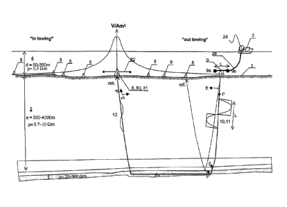
Fig. 1a illustrates an imagined geological section of a sedimentary formation
forming a petroleum reservoir, and having an overburden of about 500 m to
3000 m and a water depth of about 50 m to 350 m. The depth may be even
as shallow as 20 or 10 meters. A ship tows a marine electromagnetic
horizontally arranged signal source. The inbound leg is called the in towing )
portion of the curve with the transmitter approaching the receiver, and the
outbound leg is correspondingly called out towing . Both reflected and
refracted electromagnetic signal paths are shown between the transmitter
and the receiver. Also indicated in Fig. 1 a is a horizontal component of the
received field, shown in a logarithmic scale. In the near field the voltage
may
be very strong, so it is recommended to tow the transmitter about 50 m to 70
m over the receivers at the seafloor, otherwise the receivers may be
damaged due to the strong electromagnetic field when the transmitter passes
through the sea over the receiver.
Fig. 1 b is a simple illustration of the electromagnetic field as measured
over
one single receiver according to the field set-up of Fig. 1 a. One single
receiver with antennas is put into the figure at zero offset.
Fig. 2 illustrates the horizontal component of the amplitude of a signal
received at one station at the seafloor, from a towed electromagnetic
transmitter sending an AC current in the sea. The emitted frequency is 0.25
Hz. The signal is normalised with respect to transmitter source strength:
(Vim) /(Am)=V/Am2,
and is a source-normalised amplitude often called "magnitude".
Fig. 3 illustrates normalised curves in which a signal amplitude curve of an
anomalous formation of high resistivity, e.g. due to being petroleum-bearing,
with overburden of ordinary resistivity, like in Fig. 1a, is divided by a
corresponding signal amplitude curve as if the petroleum of the same
formation is replaced by water resulting in ordinary resistivity. The offset
along the abscissa is given in kilometers. The normalised water curve
CA 02594285 2007-07-03
WO 2006/073315
PCT/N02006/000007
8
indicating water, is a reference curve based on water-bearing reservoir
formations, is given the value 1.
Fig. 4a is such a normalised measurement curve of the horizontal in-line field
for a transmitted frequency of 0.025 Hz, i.e. a period of 40 seconds, and a
water depth of 128 m. The thickness of the model is about 1600 m
overburden of resistivity 1 Ohm-meter, and the reservoir thickness of the
model is about 100 m having a resistivity of 80 Ohm-meter. For hydrocarbon
detection in the present case with more or less horizontal petroleum-bearing
formations, the in-line response is considered more important than the cross
line response. In areas with lithological complications like salt deposits,
the
cross-line response may be more important.
Fig. 4b is a corresponding normalised curve for a transmitted frequency of
0.05 Hz, i.e. a period of 20 seconds.
Fig. 4c is a corresponding normalised curve for a transmitted frequency of
0.10 Hz, i.e. a period of 10 seconds.
Fig. 4d is a corresponding normalised curve for a transmitted frequency of
0.20 Hz, giving a period of 5 seconds.
Fig. 4e represents, the corresponding curve for 0.25 Hz, i.e. a period of 4
seconds.
Fig. 4f represents the curve for 0.5 Hz, i.e. a period of 2 seconds.
Fig. 4g is a normalised curve for 0.25 Hz and deep water, here 1024 m. It
has been assembled on the same sheet as a copy of Fig. 4e showing the
corresponding curve for 0.25 Hz and shallow water conditions, here 128 m.
One major difference between the two cases is that a portion of the shallow-
water emitted signal will leak to the air and will dominate the recorded
signals
CA 02594285 2007-07-03
WO 2006/073315
PCT/N02006/000007
9
at greater offsets.
Fig. 5a is a map of the Grane oilfield in the North Sea. The reservoir portion
of the reservoir formation is roughly outlined. A north-south running
electromagnetic survey line from 2003 is indicated across the map.
Fig. 5b is a normalised electrical magnitude plot as received on one single
receiver, Rx12, for a transmitted frequency of 0.25 Hz.
Fig. 5c shows a summary plot of normalised electrical magnitude for all
receivers. The abscissa is in meters. The receivers numbered 1 to 16 are
indicated along the abscissa, and correspond to the profile line shown in Fig.
5a. In this plot, the normalised electrical magnitude for one particular
source-
receiver offset is picked from each registration from the stations Rx1 to
Rx16.
The offset for the picked normalised field value is 5 km. It is assumed that
the
5 km offset registration indicates an electrical property value of the
potential
petroleum-bearing formation at half the offset distance, i.e. 2.5 km. The
towing direction in this figure is from the beginning of the profile to the
north.
Fig. 6a is a corresponding survey map for two electric seabed logging lines
conducted across the Grane field in 2004.
Fig. 6b is similar to Fig. 5c, but for a survey made in 2004 for tow Line 2 as
indicated in Fig. 6a.
Fig. 6c is an electrical magnitude plot as received on one single receiver,
Rx10, of line 2 of the Grane 2004 survey. The transmitted signal is a square
pulse having a fundamental frequency of f=0.02 Hz, and thus harmonic
frequencies of 3*f, 5*f, 71, and so on. The curves "0: above oil-bearing fm."
are compared to a signal registered at a reference station outside the
reservoir, the 'W: above water-bearing fm.". The displayed measured range
is in meters from 3000 m to 12000 m offset for the station Rx10, and from
CA 02594285 2007-07-03
WO 2006/073315
PCT/N02006/000007
3000 m to about 8000 m for the reference station. The ordinate axis is in log
amplitude of the source-normalised received signal, from 1013'5 V/Am2 to 10"
iiwAm2.
5 Description of preferred embodiments of the invention
The invention is a method for determining electrical properties of a submarine
petroleum fluid bearing formation 1 having an overburden 2 of geological
layers 2 thickness s and having a seafloor 3 covered in the area of interest
by
a sea 4. The method comprises the following steps:
* One or more of electromagnetic receivers 8 arranged in said sea 4. The
electromagnetic receivers 8 may be pairs of electrodes held by beams 82 of
a desired length, and carrying some signal storing device 81 held in a
receiver compartment 80 arranged for holding said antenna beams 82. Such
antenna beams are usually arranged in an orhtogonal pair and the in-line
signal is calculated from in-line components of the orthogonal pair. Said
signal storing device 81 should be provided with a clock for recording the
actual time for registering received signals 12 explained below.
* One or more transmitter antennas 9 should be arranged in the sea 4.
* Said transmitter antenna 9 is then used for transmitting electromagnetic
signals 10 of one or more pulses 11 having frequencies between 0.01 Hz and
0.10 Hz. In the present embodiment of the invention, a frequency of 0.02 Hz
has been used. Said in an alternative way, a wavelength I more than 5 times
the thickness s of said overburden layers 2 may be used. Previously, air
pulses propagating from said transmitter 9 to said antennas 8 were believed
to overshadow desired information about a geological petroleum bearing
reservoir 1, but new modelling for shallow sea depth has clearly indicated
that either a significant increase or decrease occurs for the detected signal
at
intermediate offsets, even for very shallow waters.
* The actual depth d of said sea 4 for the present invention to be carried out
is 10 or 20 to 400 meters, more preferably 50-350 meters, and most
preferably about 80 meters to about 300 meters. This corresponds to actual
CA 02594285 2007-07-03
WO 2006/073315
PCT/N02006/000007
11
depths of the North Sea. Other depths may be relevant for other sea areas of
the world.
* Much of the energy of the emitted signal pulses 11 is attenuated due to the
resistivity of the seawater, the overburden, but a small proportion of the
energy is eventually received. Electromagnetic signals 12 due to said emitted
electromagnetic signals 10 propagate for a portion of the emitted energy to
be significantly detected at said receivers 8 having an offset from said
transmitter 9, provided that said transmitter has a sufficient capacity for
emitting electromagnetic signals, as described below.
* One or more components of said detected signals 12 is analysed for offset
distances between about 3 km to about 10 km between the transmitter 9 and
receivers 8. It is expected that for such offsets, said detected signals 12
will
differ significantly from a corresponding signal 12' that would be detected
from a similar but water bearing formation 1, said differing signal indicating
that said formation 1) is petroleum-fluid bearing.
Towing method
According to the method of the invention, said one or more receivers 8 are
arranged on said seafloor 3, and said preferably one transmitter 9 is towed in
said sea 4 by a marine vessel 5, either a surface vessel or a submarine
vessel. Said transmitter 9 may be towed on said seafloor 3, but in order not
to enforce a destructive electrical current onto a receiver 8 while being
moved near the necessarily very sensitive electrical receiver 8, the
transmitter 9 could be towed 30 to 70 meters above said receiver 8 if the
track is more or less directly over the receiver. Alternatively, according to
the
method of the invention, said receivers 8 may be towed in said sea 4, said
receivers being arranged as one single towed receiver 8 or several receivers
8 arranged on a cable towed after a marine vessel 5.
According to an alternative embodiment of the invention, said receivers 8
may be towed on said seafloor 3.
CA 02594285 2007-07-03
WO 2006/073315
PCT/N02006/000007
12
Analysis
The analysis may be conducted with respect to amplitude of said detected
signals 12, using so-called 1-D modelling as illustrated in Fig. 2, and
particularly in the normalised curves in Figs. 3 and 4. A 1-D model may be
based on a single borehole log of measured resistivity of the layers of
geological formations surrounding the borehole. In a 1-D modelling there may
be no depth variation of the interfaces between the layers. In a 2-D
modelling, e.g. using resistivity measurement data from two drilled wells,
depth variation of the layers may be introduced to better match the actual
geological structure along the measured line.
Fig. 4f represents the curve for 0.5 Hz, i.e. a period of 2 seconds at a sea
depth of 128 meters. The thickness of the overburden in the model is about
1600 m of resistivity 1 Ohm-meter, and the reservoir thickness of the model
is 100 m of 80 Ohm-meter resistivity. This illustrates one major problem using
such high frequencies at relatively shallow water compared to the thickness
of the overburden: the response in the source-normalised amplitude curve is
negligible. This is modelled data, and real data would have natural
resistivity
variations with depth that could probably hide such small signal anomalies
below the noise level.
Above Fig. 4f, Fig. 4e represents the corresponding curve for 0.25 Hz, i.e. a
period of 4 seconds, for the same sea depth. A significant so-called anomaly
in the source-normalised amplitude can be seen as a slight increase in the
normalised amplitude curve between 2 and 3.5 km, and a strong decrease of
normalised amplitude starting at 3.5 km and reaching its broad minimum of
0.80 at about 4.8 km, and slowly returning to the unit curve at about 8 km.
The curve may be described as a distorted wavelet having a small narrow
positive portion followed by a larger and broader negative portion. The
corresponding wavelet of Fig. 4f is inverse and very insignificant.
CA 02594285 2007-07-03
WO 2006/073315
PCT/N02006/000007
13
Fig. 4d is a corresponding normalised curve for a transmitted frequency of
0.20 Hz, giving a period of 5 seconds. The depth is as with the other models
of Fig. 4: 128 meters. The negative anomaly is now displaced to start at 4
km, the amplitude minimum is more pronounced to a value of about 0.75 and
displaced to longer offset at 5.5 km, and rebounds further out at 10 km. The
increasing offset associated with the onset, maximum, unit crossing and
minimum, with decreasing frequency, is indicated by horizontal arrows in
Figs. 4d, 4c, and 4b.
The change of the curves are further seen with decreasing frequencies. Fig.
4c is a corresponding normalised curve for a transmitted frequency of 0.10
Hz, i.e. a period of 10 seconds. The source-normalised amplitude curve now
has its positive portion of the wavelet significantly widened and increased,
starting at 2 km, increasing to about 1.28 of the source-normalised amplitude
at an offset of about 5.2 km, and plunging below the unit line at about 6.5 km
to a minimum that is more negative than 0.75.
The effects indicated in Figs. 4d and 4c are seen further in Fig. 4b, which is
a
corresponding normalised curve for a transmitted frequency of 0.05 Hz, i.e. a
period of 20 seconds, same depth. The onset is as for 0.10 Hz at about 2 km,
but of much stronger amplitude for 0.05 Hz, increasing to more than 1.52 at
an offset of about 6.9 km, and plunging through the unit line at 9.9 km. The
negative portion of the curve is so offset that is has not been calculated
outside the offset of 10 km.
The preliminary strongest maximum is illustrated in Fig. 4a that is also such
a
normalised measurement curve of the horizontal inline field for a transmitted
frequency of 0.025 Hz, i.e. a period of 40 seconds, and a water depth of 128
m. The onset is now at about 2.2 km, and the positive portion is very broad
and is as strong as 1.62 at the normalised curve and offset with the
maximum occurring at about 9.2 km, the negative portion to be found far off
10 km, if existing.
CA 02594285 2007-07-03
WO 2006/073315
PCT/N02006/000007
14
It can be seen from the calculated source-normalised amplitude curves that
using very low frequencies in the range from about 0.025 Hz to about 0.25
Hz, far more significant anomalies may be found using a model of a high-
resistivity formation below an overburden of ordinary resistivity, and shallow
sea water. Knowing the depth and the thickness of the potentially petroleum-
bearing formation from seismic analysis, but not the resistivity, that
particular
question may be given an answer using the method according to the
invention.
Fig. 4g is a normalised curve for 0.25 Hz and deep water, here 1024 m. It
has been assembled on the same sheet as a copy of Fig. 4e showing the
corresponding curve for 0.25 Hz and shallow water conditions, here 128 m.
What is clearly seen is that for deep water, a very clear and significant
normalised signal over the oil-bearing formation in deep water is seen, as
compared to the normalised curve over shallow water. One major difference
between the two cases is that for shallow water conditions, a larger portion
of
the emitted signal may leak to the air and have a significant influence on the
recorded signal. However, attempts for separation of up- and down-going
fields, as well as air-wave subtraction, has so far been unsuccessfully tried.
It
is highly desirable to have an electromagnetic method that provides more
significant electromagnetic anomalies above oil-bearing formations also for
shallow waters.
Signal emission
According to a preferred embodiment of the invention, said transmitted signal
pulses 11 being generally square pulses comprising first, harmonic cosine
waves being detectable far away. One advantage using low frequencies
according to the invention is that also third harmonic waves and fifth
harmonic waves may be detectable at said intermediate distances. This
makes it possible to conduct independent analyses for different frequencies.
Using a base frequency for the transmitted square pulse of 0.02 Hz, one
would receive a remote signal composed of the following:
CA 02594285 2007-07-03
WO 2006/073315
PCT/N02006/000007
* a cosine wave of 0.02 Hz,
* a third harmonic cosine wave of 0.02*3 Hz = 0.06 Hz, having one third of
the energy,
* a fifth harmonic cosine wave of 0.02 * 5 Hz = 0.10 Hz, having one fifth
of
5 the energy,
* a seventh harmonic cosine wave of 0.02 * 7 Hz = 0.14 Hz, and so on, all
of
which may be independently filtered and analysed, broadening the basis of
analysis. The different harmonic waves will have different propagation
speeds.
Below are listed propagation velocity and electromagnetic wavelength for
some values of overburden resistivity and emitted low frequencies.
R (Ohm-m) f (Hz) velocity (m/s) wavelength lambda (m)
1 0.02 Hz 447 m/s 22400 m
2 0.02 Hz 632 m/s 31600m
3 0.02 Hz 775 m/s 38700 m
1 0.06 Hz 775 m/s 12900 m
2 0.06 Hz 1095 m/s 18300m
3 0.06 Hz 1342 m/s 22400 m
1 0.10 Hz 1000 m/s 10000 m
2 0.10 Hz 1414 m/s 14000m
3 0.10 Hz 1732 m/s 17300 m
1 0.20 Hz 1414 m/s 7070m
2 0.20 Hz 2000 m/s 10000 m
3 0.20 Hz 2449 m/s 12200m
CA 02594285 2007-07-03
WO 2006/073315
PCT/N02006/000007
16
It may be seen that the wavelengths used for 1, 2 or 3 Ohm-meter resistivity
in the overburden sending with a very low frequency of 0.02 Hz result in
extremely long wavelengths of between 22400 m and 38700 m.
Transmitter antenna
.According to the invention, said transmitter antenna 9 has an equivalent
product of current I times length L component in the horizontal direction of
between about 10000 Am, preferably up to 300000 Am or more, in general
horizontally, as explained below. The transmitter antenna 9 should preferably
be arranged to carry an electrical current between about 80 A and 2000 A,
and have a length of 50 to 500 m. Transmitting the signal may then comprise
simply to produce a DC of, say, about 80 A to about 2000 A, preferably in the
range from 100 A to 1000 A, and sending the direct current through the two
transmitter electrodes 9A, 9B arranged about 5-70 m above the seafloor
separated by a generally horizontal distance of about 50 m to about 500 m,
preferably about 100 to about 300 m, producing an equivalent product of
about 400 Am to about 1000000 Am, preferably from 10000 Am to 300000
Am. Using a base frequency for the transmitted square pulse of 0.02 Hz as
used in the present example, i.e. having a period of 50 s, one may simply
reverse the electrical current each 25 second to produce the electrical square
pulse of length 50 s desired.
Results
Fig. 2 illustrates the horizontal component of the amplitude of a signal
received at one station at the seafloor, from a towed electromagnetic
transmitter sending an AC current in the sea. The signal comprises both
received reflected signals and refracted signals, direct signals through the
seawater, and partially air propagated wave signals. One pair of curves is
calculated according to a model with shallow water, 128 m, and the other pair
of curves is calculated according to a model with deep water, 4000 m. The
emitted frequency is 0.25 Hz. The denomination of the ordinate is given in
electrical field strength V/m normalised with respect to transmitter source
CA 02594285 2007-07-03
WO 2006/073315
PCT/N02006/000007
17
strength Am, (V/m) /(Am)=V/Am2, a source-normalised amplitude called
magnitude. The noise floor is often considered to be between 10-15 WAM2 to
10-13 V/Am2. The offset along the abscissa is in kilometers. The lower pair of
curves indicate the amplitude of the electrical horizontal field as measured
in
deep water, here 4000 m. For offsets more than about 2000 meters, the
curve calculated for an oil-bearing formation is above the curve indicating a
water-bearing formation, and the difference is quite distinguishable. The
upper pair of curves however, is calculated for shallow water, here 128 m. A
reduction of amplitude is seen between 4500 and 8000 m in this view, but the
10,
difference is rather small, and may be masked rather easily by other effects
like noise.
Fig. 3 illustrates normalised curves in which a signal amplitude curve of an
anomalous formation of high resistivity, e.g. due to being petroleum-bearing,
with overburden of ordinary resistivity, like in Fig. 1a, is divided by a
corresponding signal amplitude curve as if the petroleum of the same
formation is replaced by water resulting in ordinary resistivity. The offset
along the abscissa is given in kilometers. A dashed line indicating the
amplitude curve due to the anomalous oil-bearing formation for a 0.25 Hz
transmitted wave is indicated. The normalised gwater curve* indicating
water, is a reference curve based on water-bearing reservoir formations, is
given the value 1. This may be done using data from a data acquisition
profile crossing a portion of the formation that is known to be water-bearing.
Between 3.5 and 8 km, the resistivity of the water-bearing formation is lower
than if the same formation was petroleum-bearing. A line indicating the
amplitude curve due to the anomalous oil-bearing formation for a 0.25 Hz
wave as calculated for shallow water depth of 128 m is indicated. In this
view,
it is more clearly seen that there is a small but significant difference for
0.25
Hz, but this difference is vulnerable to noise.
Fig. 5a is a map of the electromagnetic seabed logging program in 2003 over
the Grane oilfield in the North Sea. The reservoir portion of the reservoir
CA 02594285 2007-07-03
WO 2006/073315
PCT/N02006/000007
18 =
formation is roughly outlined. A north-south running electromagnetic
sounding line is indicated across the map. Receiver stations 12, 13, 14, 15,
and 16 are placed in the portion of the profile across the northern limits of
the
oil-baring formation in this profile. Receiver stations 1-11 are placed in the
portions of the profile across the southern limits of the oil-bearing
formation in
this profile. Over the central portions of profile over the petroleum-bearing
formation of the Grane field, no receivers are placed.
Fig. 5b is a normalised electrical magnitude plot as received on one single
receiver, Rx12, for a transmitted frequency of 0.25 Hz. The wateN-curve
and the HC> -curve show a small but significant difference between 4 and
about 7 km in these real data.
Fig. 5c shows a summary plot of normalised electrical magnitude for all
receivers. The abscissa is in meters. The receivers 1-16 are indicated along
the abscissa, and correspond to the profile line shown in Fig. 5a. In this
plot,
the normalised electrical magnitude for one particular source-receiver offset
is picked from each registration from the stations Rx1-Rx16. The offset for
the picked normalised field value is 5 km. It is assumed that the 5 km offset
registration indicates an electrical property value of the potential petroleum-
bearing formation at half the offset distance, i.e. 2.5 km. The towing
direction
in this figure is from the beginning of the profile to the north, i.e. to the
right of
receiver station 16 in Fig. 5c, and toward left in Fig. 5c. Thus the "in
towing"
picked value at 5 km for station Rx4 is plotted 2.5 km ahead of station Rx4,
and the "out towing" value at 5 km for station Rx4 is plot 2.5 km after
station
Rx4. There is a small reduction in amplitude values plotted for the points
residing inside the Grane petroleum field outline indicated in Fig. 5c, but
low
values are found also for the in towing picked plots for station 12, 14, 15,
and 16 to the north of the Grane field outline, which may be due to an
increase of the thickness of the underlying chalk formation or undiscovered
oil north of the present Grane field outline. Please notice that there is a
difference for the in-towing and out-towing electrical normalised 5 km picked
CA 02594285 2007-07-03
WO 2006/073315
PCT/N02006/000007
19
value, particularly significant for e.g. receiver station Rx8. In the in-
towing
southbound leg to Rx8, the transmitter and receiver are both above an oil-
bearing part of the reservoir formation, and the resulting 5 km value is about
0.88. In the out-towing southbound leg from Rx8, the transmitter is over the
water-bearing part of the reservoir formation, and the resulting 5 km value is
about 1.04. Other offsets than 5 km may be used for selecting the value.
Fig. 6a is a corresponding survey map for two electric seabed logging profiles
conducted across the Grane field in 2004. Line 1 has a direction more or less
north - south with receivers Rx01 to Rx07, and Line 2 is NNE-SSW with
receivers Rx08 to Rx12. Receiver station Rx04 is at the crossing point
between Line 1 and Line 2.
Fig. 6b is similar to Fig. 5c, but for a survey made in 2004 for tow Line 2 as
indicated in Fig. 6a. Fig. 6b shows a summary plot of normalised electrical
magnitude for all receivers along Line 2. The abscissa is in meters. The
receivers Rx08, Rx09, Rx04, and Rx10 are indicated along the abscissa, and
correspond to the profile line shown in Fig. 5a. In this plot, the normalised
electrical magnitude for one particular source-receiver offset is picked from
each registration from the stations Rx08, Rx09, Rx04, and Rx10. The source-
receiver offset for the picked normalised field values are 7 km, and the
values
are plot halfway, 3.5 km from the receiver and 3.5 km from the transmitter. It
is indicated in the shadowed columns between 7 and 13 km, and between 15
and 17.5 km where the Hydro estimated petroleum reservoir extends. In this
survey is used ,a square pulse of very low transmitter frequency of 0.02 Hz.
In
this plot, the 31 and 51 harmonic wave components have been analysed.
Both the 3*f and 51 harmonic normalised plots display a much more distinct
signal ratio, varying between about 1.06 and 1.10 at the transition between
petroleum-bearing formation at station Rx09, to between about 1.22 and 1.30
to the SW of station Rx10 near the middle of the petroleum-bearing
formation. This result from the 2004 survey using a square pulse of 0.02 Hz
indicates more distinctly the presence of petroleum in the reservoir formation
CA 02594285 2007-07-03
WO 2006/073315
PCT/N02006/000007
than the plot from the 2003 survey using a wave frequency of 0.25 Hz.
Another difference is that the ratio is above unity for the ultra-low
frequency
of 0.02 Hz used, as compared to the below unity ratio for the wave frequency
of 0.25 Hz used.
5
Fig. 6c is an electrical magnitude plot as received on one single receiver,
Rx10, of line 2 of the Grane 2004 survey. The transmitted signal is a square
pulse having a fundamental frequency of f=0.02 Hz, and thus the emitted
signal contains harmonic frequencies of 31, 51, 7*f, and so on. Station Rx10
10 is situated above an oil-bearing portion of the reservoir. The curves
are also
compared to a signal registered at a reference station outside the reservoir,
which may be used for normalising. The displayed measured range is in
meters from 3000 m to 12000 m offset for the station Rx10, and from 3000 m
to about 8000 m for the reference station. The ordinate axis is in log
15 amplitude of the source-normalised received signal, from 10-13.5 V/Am2
to 10-
\HA 2.
m Even without normalising the received signals, the received
fundamental frequency signal f=0.02 Hz and the odd harmonics filtered
31=0.06 Hz and 51=0.10 Hz, clearly display a response that is generally
higher than the signal from the reference station. Beyond 8000 m no
20 reference signal for comparison has been plotted. The f=0.02 Hz "above
oil"
signal over the oil-bearing portion of the formation is distinctly higher than
the
reference signal between about 5000 m and 8000 m. The f=0.02 Hz signal is
so far in rough agreement with the range of which the theoretical curve of
0.025 Hz of Fig. 4a is above normalised unity. The 31=0.06 Hz is over the
reference curve of Fig. 6c between 5.5 km and at least 8 km offset, also
being in rough agreement with the closest modelled curve of 0.05 Hz. The 51
curve is below the reference curve between about 5.5 km and 6 km, and
above unity between about 6 km and about 7.7 km, not being entirely in
agreement with the offset range of the modelled data for 0.10 Hz, but
significantly differing from the "above-water" signal.