Note: Descriptions are shown in the official language in which they were submitted.
CA 02594762 2007-07-12
WO 2006/091461 PCT/US2006/005410
METHOD FOR IDENTIFYING SUBSURFACE FEATURES FROM
MA1?IINE TRANSIENT CONTROLLED SOURCE ELECTROMAGNETIC
SURVEYS
Cross-reference tq related applications
Not applicable.
Statement regarding federally sponsored research or development
Not applicable.
Background of Invention
Field of the Invention
[0001] The invention relates generally to the field of controlled source
marine
electromagnetic surveying. More specifically, the invention relates to methods
for
processing and display of data from marine transient electromagnetic surveys
such that
subsurface features may be identified.
Background Art
[0002] Marine electromagnetic surveying includes "controlled source"
surveying.
Controlled source surveying includes imparting an electric current or a
magnetic field
into the sea floor, and measuring voltages and/or magnetic fields induced in
electrodes,
antennas and/or magnetometers disposed on the sea floor. The voltages and/or
magnetic
fields are induced in response to the electric current andlor magnetic field
imparted into
the Earth's subsurface through the sea floor.
[0003] Controlled source surveying known in the art typically includes
imparting
alternating electric current into the sea floor. The alternating current has
one or more
selected frequencies. Such surveying is known as frequency domain controlled
source
electromagnetic (f-CSEM) surveying. f-CSEM surveying techniques are described,
for
1
CA 02594762 2007-07-12
WO 2006/091461 PCT/US2006/005410
example, in Sinha, M.C. Patel, P.D., Unsworth, M.J., Owen, T.R.E., and
MacCormack,
M.G.R., 1990, An active source electromagnetic sounding system for marine use,
Marine
Geophysical Research, 12, 29-68. Other publications which describe the physics
of and
the interpretation of electromagnetic subsurface surveying include: Edwards,
R.N., Law,
L.K., Wolfgram, P.A., Nobes, D.C., Bone, M.N., Trigg, D.F., and DeLaurier,
J.M., 1985,
First results of the MOSES experiment: Sea sediment conductivity and thickness
determination, Bute Inlet, British Columbia, by magnetometric offshore
electrical
sounding: Geophysics 50, No. 1, 153-160; Edwards, R.N., 1997, On the resource
evaluation of marine gas hydrate deposits using the sea-floor transient
electric dipole-
dipole method: Geophysics, 62, No. 1, 63-74; Chave, A.D., Constable, S.C. and
Edwards,
R.N., 1991, Electrical exploration methods for the seafloor: Investigation in
geophysics
No 3, Electromagnetic methods in applied geophysics, vol. 2, application, part
B, 931-
966; and Cheesman, S.J., Edwards, R.N., and Chave, A.D., 1987, On the theory
of sea-
floor conductivity mapping using transient electromagnetic systems:
Geophysics, 52, No.
2,204-217.
(0004] Following are described several patent publications which describe
various
aspects of electromagnetic subsurface Earth surveying. U.S. Patent No.
5,770,945 issued
to Constable describes a magnetotelluric (MT) system for sea floor petroleum
exploration. The disclosed system includes a first waterproof pressure case
containing a
processor, AC-coupled magnetic field post-amplifiers and electric field
amplifiers, a
second waterproof pressure case containing an acoustic navigation/release
system, four
silver-silver chloride electrodes mounted on booms and at least two magnetic
induction
coil sensors. These elements are mounted together on a plastic and aluminum
frame
along with flotation devices and an anchor for deployment to the sea floor.
The acoustic
navigation/release system serves to locate the measurement system by
responding to
acoustic "pings" generated by a ship-board unit, and receives a release
command which
initiates detachment from the anchor so that the buoyant package floats to the
surface for
recovery. The electrodes used to detect the electric field are configured as
grounded
dipole antennas. Booms by which the electrodes are mounted onto a frame are
positioned
in an X-shaped configuration to create'two orthogonal dipoles. The two
orthogonal
2
CA 02594762 2007-07-12
WO 2006/091461 PCT/US2006/005410
dipoles are used to measure the complete vector electric field. The magnetic
field sensors
are multi-turn, Mu-metal core wire coils which detect magnetic fields within
the
frequency range typically used for land-based MT surveys. The magnetic field
coils are
encased in waterproof pressure cases and are connected to the logger package
by high
pressure waterproof cables. The logger unit includes amplifiers for amplifying
the
signals received from the various sensors, which signals are then provided to
the
processor which controls timing, logging, storing and power switching
operatibns.
Temporary and mass storage is provided within and/or peripherally to the
processor.
[0005] U.S. Patent No. 6,603,313 B1 issued to Srnka discloses a method for
surface
estimation of reservoir properties, in which location of and average earth
resistivities
above, below, and horizontally adjacent to subsurface geologic formations are
first
determined using geological and geophysical data in the vicinity of the
subsurface
geologic formation. Then dimensions and probing frequency for an
electromagnetic
source are determined to substantially maximize transmitted vertical and
horizontal
electric currents at the subsurface geologic formation, using the location and
the average
earth resistivities. Next, the electromagnetic source is activated at or near
surface,
approximately centered above the subsurface geologic formation and a plurality
of
components of electromagnetic response is measured with a receiver array.
Geometrical
and electrical parameter constraints are determined, using the geological and
geophysical
data. Finally, the electromagnetic response is processed using the geometrical
and
electrical parameter constraints to produce inverted vertical and horizontal
resistivity
depth images. Optionally, the inverted resistivity depth images may be
combined with the
geological and geophysical data to estimate the reservoir fluid and shaliness
properties.
[0006) U.S. Patent No. 6,628,110 Bl issued to Eidesmo et al. discloses a
method for
determining the nature of a subterranean reservoir whose approximate geometry
and
location are known. The disclosed method includes: applying a time varying
electromagnetic field to the strata containing the reservoir; detecting the
electromagnetic
wave field response; and analyzing the effects on the characteristics of the
detected field
that have been caused by the reservoir, thereby determining the content of the
reservoir,
based on the analysis.
3
CA 02594762 2007-07-12
WO 2006/091461 PCT/US2006/005410
[0007] U.S. Patent No. 6,541,975 B2 issued to Strack discloses a system for
generating
an image of an Earth formation surrounding a borehole penetrating the
formation.
Resistivity of the formation is measured using a DC measurement, and
conductivity and
resistivity of the formations is measured with a time domain signal or AC
measurement.
Acoustic velocity of the formation is also measured. The DC resistivity
measurement, the
conductivity measurement made with a time domain electromagnetic signal, the
resistivity measurement made with a time domain electromagnetic signal and the
acoustic
velocity measurements are combined to generate the image of the Earth
formation.
[0008] International Patent Application Publication No. WO 0157555 Al
discloses a
system for detecting a subterranean reservoir or determining the nature of a
subterranean
reservoir whose position and geometry is known from previous seismic surveys.
An n
electromagnetic field is applied by a transmitter on the seabed and is
detected by
antennae also on the seabed. A refracted wave component is sought in the wave
field
response, to determine the nature of any reservoir present.
[0009] International Patent Application Publication No. WO 03048812 Al
discloses an
electromagnetic survey method for surveying an area previously identified as
potentially
containing a subsea hydrocarbon reservoir. The method includes obtaining first
and
second survey data sets with an electromagnetic source aligned end-on and
broadside
relative to the same or different receivers. The invention also relates to
planning a survey
using this method, and to analysis of survey data taken in combination allow
the galvanic
contribution to the signals collected at the receiver to be contrasted with
the inductive
effects, and the effects of signal attenuation, which are highly dependent on
local
properties of the rock formation, overlying water and air at the survey area.
This is very
important to the success of using electromagnetic surveying for identifying
hydrocarbon
reserves and distinguishing them from other classes of structure.
[0010] U.S. Patent No. 6,842,006 Bl issued to Conti et al. discloses a sea-
floor
electromagnetic measurement device for obtaining underwater magnetotelluric
(MT)
measurements of earth formations. The device includes a central structure with
arms
pivotally attached thereto. The pivoting arms enable easy deployment and
storage of the
4
CA 02594762 2007-07-12
WO 2006/091461 PCT/US2006/005410
device. Electrodes and magnetometers are attached to each arm for measuring
electric
and magnetic fields respectively, the magnetometers being distant from the
central
structure such that magnetic fields present therein are not sensed. A method
for
undertaking sea floor measurements includes measuring electric fields at a
distance from
the structure and measuring magnetic fields at the same location.
[0011] U.S. Patent Application Publication No. 2004 232917 relates to a method
of
mapping subsurface resistivity contrasts by making multichannel transient
electromagnetic (MTEM) measurements on or near the Earth's surface using at
least one
source, receiving means for measuring the system response and at least one
receiver for
measuring the resultant earth response. All signals from the or each source-
receiver pair
are processed to recover the corresponding electromagnetic impulse response of
the earth
and such impulse responses, or any transformation of such impulse responses,
are
displayed to create a subsurface representation of resistivity contrasts. The
system and
method enable subsurface fluid deposits to be located and identified and the
movement of
such fluids to be monitored.
[0012] U.S. Patent No. 5,467,018 issued to Rueter et al. discloses a bedrock
exploration
system. The system includes transients generated as sudden changes in a
transmission -
stream, which are transmitted into the Earth's subsurface by a transmitter.
The induced
electric currents thus produced are measured by several receiver units. The
measured
values from the receiver units are passed to a central unit. The measured
values obtained
from the receiver units are digitized and stored at the measurement points,
and the central
unit is linked with the measurement points by a telemetry link. By means of
the
telemetry link, data from the data stores in the receiver units can be
successively passed
on to the central unit.
[0013] U.S. Patent No. 5,563,913 issued to Tasci et al. discloses a method and
apparatus
used in providing resistivity measurement data of a sedimentary subsurface.
The data are
used for developing and mapping an enhanced anomalous resistivity pattern. The
enhanced subsurface resistivity pattern is associated with and an aid for
finding oil a.nd/or
gas traps at various depths down to a basement of the sedimentary subsurface.
The
CA 02594762 2007-07-12
WO 2006/091461 PCT/US2006/005410
apparatus is disposed on a ground surface and includes an electric generator
connected to
a transmitter with a length of wire with grounded electrodes. When large
amplitude, long
period, square waves of current are sent from a transmission site through the
transmitter
and wire, secondary eddy currents are induced in the subsurface. The eddy
currents
induce magnetic field changes in the subsurface which can be measured at the
surface of
the earth with a magnetometer or induction coil. The magnetic field changes
are received
and recorded as time varying voltages at each sounding site. Information on
resistivity
variations of the subsurface formations is deduced from the amplitude and
shape of the
measured magnetic field signals plotted as a function of time after applying
appropriate
mathematical equations. The sounding sites are arranged in a plot-like manner
to ensure
that areal contour maps and cross sections of the resistivity variations of
the subsurface
formations can be prepared.
[0014] A limitation to f-CSEM techniques known in the art is that they are
typically
limited to relatively great water depth, on the order of 800-1,000 meters, or
a ratio of
ocean water depth to subsurface reservoir depth (reservoir depth measured from
the sea
floor) of greater than about 1.5 to 2Ø
[00151 A typical f-CSEM marine survey can be described as follows. A recording
vessel
includes cables which connect to electrodes disposed on the sea floor. An
electric power
source on the vessel charges the electrodes such that a selected magnitude of
current
flows through the sea floor and into the Earth formations below the sea floor.
At a
selected distance ("offset") from the source electrodes, receiver electrodes
are disposed
on the sea floor and are coupled to a voltage measuring circuit, which may be
disposed
on the vessel or a different vessel. The voltages imparted into the receiver
electrodes are
then analyzed to infer the structure and electrical properties of the Earth
formations in the
subsurface.
[0016) Another technique for electromagnetic surveying of subsurface Earth
formations
known in the art is transient controlled source electromagnetic surveying (t-
CSEM). In t-
CSEM, electric current is imparted into the Earth at the Earth's surface, in a
manner
similar to f-CSEM. The electric current may be direct current (DC). At a
selected time,
6
CA 02594762 2007-07-12
WO 2006/091461 PCT/US2006/005410
the electric current is switched off, and induced voltages and/or magnetic
fields are
measured, typically with respect to time over a selected time interval, at the
Earth's
surface. Structure of the subsurface is inferred by the time distribution of
the induced
voltages and/or magnetic fields. t-CSEM techniques are described, for example,
in
Strack, K.-M., 1992, Exploration with deep transient electromagnetics,
Elsevier, 373 pp.
(reprinted 1999).
[0017] t-CSEM shows promise as a technique for mapping the Earth's subsurface
in
relatively shallow marine environments, such as when the water depth is less
than about 2
times the depth of a reservoir or other electromagnetically identifiable
feature in the
Earth's subsurface. What is needed is an improved technique for identification
and
mapping features in the Earth's subsurface using t-CSEM survey data.
Summary of Invention
[0018] One aspect of the invention is a method for identifying features in the
Earth's
subsurface below a body of water using transient controlled source
electromagnetic
measurements. A method according to this aspect of the invention includes
acquiring a
plurality of transient controlled source electromagnetic measurements. Each
measurement represents a different value of an acquisition parameter. Each
measurement
is indexed with respect to a time at which an electric measuring current
source is
switched. The plurality of measurements is processed in a seismic trace
display format,
in which each trace corresponds to the measurement acquired for a value of the
acquisition parameter. A subsurface feature is identified from the processed
measurerhents.
[0019] Other aspects and advantages of the invention will be apparent from the
following
description and the appended claims.
Brief Description of Drawings
[0020] Figure 1 shows a typical data acquisition system and process for marine
electromagnetic surveying.
7
CA 02594762 2007-07-12
WO 2006/091461 PCT/US2006/005410
[0021] Figure 2A shows a graph of difference between induced voltages measured
for a
uniformly conductive Earth having a resistive feature located at various
depths below the
bottom of a body of water and induced voltages measured where there is no such
resistive
feature.
[0022] Figure 2B shows a prior art style graphs of induced voltage with
respect to time
for a reservoir or resistive feature at various depths below the water bottom.
[0023] Figure 3 shows one implementation of a data display and feature
identification
technique according to the iiivention.
[0024] Figure 4 shows seismic style data traces representing differences
between low
resistivity response from Figure 3a.nd successively higher resistivity
responses from
Figure 3.
[0025] Figure 5 shows a trace set corresponding to various source to receiver
offsets.
[0026] Figures 6A and 6B, respectively, show magnified time scale traces from
Figure 5,
and second derivatives of the traces of Figure 5.
[0027] Figures 7, 8A and 8B show traces from a simulation similar to that of
Figures 5,
6A and 6B, and include response of a resistive feature.
[0028] Figure 9A shows apparent resistivity differences between the no-
resistive-feature
simulation of Figure 5, for various offsets, and the corresponding simulation,
for various
offsets, including the resistive feature as shown in Figure 7.
[0029] Figure 9B shows second derivatives of the difference curves of Figure
9A.
[0030] Figures l0A and lOB show, respectively, simulated t-CSEM response in
various
water depths, without and with a resistive feature.
[0031] Figure 11 shows differences between the no-feature responses of Figure
10A and
the resistive feature responses of Figure l OB.
[0032] Figures 12A and 12B show the response, and second derivative thereof,
respectively, for various resistivities of a resistive feature in a modeled
system including
a water layer and a sediment layer.
8
CA 02594762 2007-07-12
WO 2006/091461 PCT/US2006/005410
[0033] Figures 13A and 13B show, respectively, differences in response between
the no-
feature response of Figure 12A, and responses of various resistivities of
resistive feature,
and the second derivatives thereof.
Detailed Description
[0034] Methods of electromagnetic data display and feature identification were
tested by
simulating response of a marine transient electromagnetic survey. Referring to
Figure 1,
the model simulates a survey vessel 10 which deploys a dipole electric
transmitter, shown
as electrodes A and B disposed on the bottom 12A of a body of water 12. For
purposes
of the simulation, the electrode spacing is set at 500 meters. An electric
current source
(not shown separately) is energized to cause 100 Amperes of current to flow
through the
electrodes A, B. This is equivalent to typical survey practice known in the
art using a
100 meter long transmitter dipole, and using 500 Amperes current. In either
case the
source moment is 5X10⁴ Ampere-meters. For purposes of the simulation, the
current is
modeled as direct current (DC) and is switched off at a time index equal to
zero. It
should be understood, however, that switching the DC off is only one
implementation of
electric current change that is operable to induce transient electromagnetic
effects. In -
other embodiments, the current may be switched on, may be switched from one
polarity
to the other (bipolar switching), or may be switched in a pseudo-random binary
sequence
(PRBS) or any hybrid derivative of such switching sequences. See, for example,
Duncan,
P.M., Hwang, A., Edwards, R.N., Bailey, R.C., and Garland., G.D., 1980, The
development and applications of a wide band electromagnetic sounding system
using
pseudo-noise source. Geophysics, 45, 1276-1296 for a description of PBRS
switching.
[0035] An electric dipole receiver includes a time-indexed voltage measuring
system 15
(which may be on the vessel 10) coupled to electrodes C and D also on the
water bottom
12A. The receiver electrodes C, D are spaced apart at 100 meters. A typical
survey
technique known in the art uses 10 meter spacing for the receiver dipole
electrodes. For
purposes of evaluating simulation results the induced voltages should be
normalized for
the simulated receiver electrode spacing. A source to receiver offset is in an
initial model
9
CA 02594762 2007-07-12
WO 2006/091461 PCT/US2006/005410
case set to 200 meters. Various offsets up to 3,000 meters and more were used
in
subsequent simulations of response.
[0036] For this model, the electric field transmitted and detected component
are referred
to as the Ex EX component (inline source, inline receiver), which is believed
sufficient for
an initial evaluation of the method of this invention.
[0037] The modeling technique is described in Edwards, R.N., 1997, On the
resource
evaluation of marine gas hydrate deposits using the sea-floor transient
electric dipole-
dipole method, Geophysics, 62, 63-74. The applicability of the foregoing
modeling
technique was substantiated by reference to Cheesman, S.J., Edwards, R.N., and
Chave,
A.D., 1987, On the theory of seafloor conductivity mapping using transient EM
systems,
Geophysics, 52, 204-217. Similar modeling results can be obtained for magnetic
field
responses using electric and magnetic field transmitters.
[0038] The model used represents three discrete layers. First is the body of
water 12.
The water 12 is modeled as to have an electrical resistivity of 0.333 Ohm-
meters. A
resistive feature 16, which has a simulate thickness of 100 meters and a
resistivity of 20
Ohm-meters, is located various depths 20 below the water bottom 12A. The
resistive
feature 16 is overlain by a sediment layer 14 having a resistivity of 1.0 Ohm-
meters. In
the simulation results, to be described below with reference to Figure 2, the
water depth
18 is set at 200 meters. The resistive feature 16 is intended to include
within the
simulation a subsurface layer which has electrical properties not unlike a
hydrocarbon
bearing reservoir. One of the objectives of electromagnetic surveying known in
the art is
to establish and/or confirm the presence of such subsurface hydrocarbon
reservoirs.
[0039] A display of simulation results using display techniques known in the
art for
transient controlled source electromagnetic survey (t-CSEM) data is shown in
Figure 2.
The graph in Figure 2B shows, for a source to receiver offset of 200 meters,
and a
resistive feature (16 in Figure 1) having a resistivity of 20 Ohm-meters, the
induced
voltage with respect to time, on a logarithmic time scale, from the time the
electric
current is switched off. The curves in Figure 2B show the expected voltage
response for
the resistive feature (16 in Figure 1) for depths below the water bottom of
500 meters
CA 02594762 2007-07-12
WO 2006/091461 PCT/US2006/005410
(shown by curve 30), 1000 meters (shown by curve 32), 1500 meters (shown by
curve
32) and 2000 meters (shown by curve 36). Curve 38 shows the response where
there is
no resistive feature in the model, meaning that the Earth is represented by a
uniform half
space of resistivity 1.0 Ohm-meters below the water bottom (12A in Figure 1)
[0040] Differences between the simulated responses for each respective
resistive feature
depth, and the simulated response with no resistive feature, are shown in
Figure 2A by
curves 22, 24, 26 and 28, respectively.
[0041] It has been determined that using well known seismic data display
techniques, it is
possible to identify certain features in the Earth from transient
electromagnetic
measurements. Generally, in display and identification techniques according to
the
invention, seismic "wiggle trace" methods (and computer programs therefor)
known in
the art may be used to display the measurements with respect to time of the
current
switching, wherein the time scale is linear, and in a visual display of data,
typically the
area between the trace (curve) and a fixed reference, usually zero trace
amplitude, is
shaded or blackened for ease of visual interpretation. In a seismic style
trace display
according to the invention, a plurality of measurements with respect to time
(individually
called "traces") may be displayed on the same plot or view, or processed in a
particular
data set, wherein a parameter related to acquisition and/or processing is
different for each
successive measurements trace on the multi-trace plot. By displaying the data
in this
manner, it is possible to identify certain features in the Earth's subsurface
more readily
than using prior art data display techniques.
[0042] An example of such displays is shown in Figure 3. Each trace, 40, 42,
44, 46, 48
represents the simulated response of a physical system as shown in Figure 1,
with water
layer depth of 800 meters and a water resistivity of 0.333 Ohm-meters. The
offset is
3,000 meters and there is no resistive feature (uniform Earth below the water
bottom).
The sediment resistivity represented by each trace varies from 1.0 ohm-meters
(shown by
curve 40) to 2 Ohm-meters (shown by curve 42), 5 Ohm-meters (shown by curve
44), 10
Ohm-meters (shown by curve 46) and 20 Ohm-meters (shown by curve 48). The 1
Ohm-
meter curve 40 shows only a response called the "ocean wave" 40B, which is
essentially
11
CA 02594762 2007-07-12
WO 2006/091461 PCT/US2006/005410
the transient electromagnetic response of the water (12 in Figure 1). As the
sediment
resistivity is increased, however, a feature becomes visible in each curve,
this feature
shown at 42A, 44A, 46A, 48A, respectively. The feature corresponds to the
sediment
electromagnetic response, and it increases in amplitude and becomes shallower
in time as
the resistivity of the sediment increases.
[0043] Figure 4 shows curves 50, 52, 54, 56 representing a difference,
respectively,
between curves 42 and 40, 44 and 40, 46 and 40 and 48 and 40 in Figure 3. The
difference curves in Figure 4 essentially null the ocean wave (40B through 48B
in Figure
3) response and magnify the sediment layer response (42A through 48A in Figure
3).
Other data displays, one of which will be discussed in detail below, include
having each
trace represent the first derivative of the measured value, the second
derivative of the
measured value, or combinations of derivatives.
[0044] In another embodiment, seismic style data displays may be made of the
transient
electromagnetic response for various offsets in order to identify subsurface
features.
Where the offset is varied, it is useful to normalize the amplitude response
for each
offset. In electrical geophysics usually apparent resistivities are used to
display the data.
Apparent resistivities are curves that give the user an indication of how the
resistivity of
the subsurface changes, by normalizing the response curve to some selected
reference.
The generic definition of apparent resistivity is the resistivity of a
homogeneous half-
space that under the same survey condition yields the measured voltage.
Apparent
resistivity is used to normalize the voltage response curves and to remove the
effects of
known geometric parameters, such as source current, source length, receiver
length.
Offset distance correction allows the user to observe the effect of the
relative influences
of sediments and sea water in a marine t-CSEM survey. It is similar to the
spherical
divergence correction in seismic processing. Since the total amplitude of the
measured
voltage decreases as the cube of the offset (as contrasted with the square of
offset, as with
a seismic source), plotting voltages instead of apparent resistivity would
make the
amplitude of a voltage curve for 3,000 meter offset appear 25 times smaller
when
compared to a 600 meter offset voltage curve. Other normalization factors are
possible
depending upon physics and display objectives.
12
CA 02594762 2007-07-12
WO 2006/091461 PCT/US2006/005410
[0045] Figure 5 shows a multiple trace plot of apparent resistivity values for
a simulation
using an 800 meter deep, 0.333 Ohm-meter resistivity water layer, 1.0 Ohm-
meter
sediment below the water layer and no resistive feature. Electromagnetic
transient
response for offsets of 600, 1200, 1800, 2400 and 3000 meters are shown by
traces 60,
62, 64, 66, and 68, respectively. Figure 6A shows the responses of Figure 5 on
a much
shorter time scale, at curves 70, 72, 74, 76 and 78 respectively corresponding
to curves
60, 62, 64, 66 and 68 in Figure 5, and the second derivative of the responses,
respectively
shown by curves 80, 82, 84, 86 and 88 in Figure 6B.
[0046] Another simulation includes the same water and sediment layers, and
includes a
resistive feature, 100 meters thick, 100 Ohm-meters resistivity, and located
500 meters
below the water bottom in the sediment layer. Results of the simulation are
shown in
Figure 7, which includes traces of the apparent resistivity for various offset
values. The
offset values are 600 meters (shown by curve 90), 1200 meters (shown by curve
92),
1800 meters (shown by curve 94), 2400 meters (shown by curve 96) and 3000
meters
(shown by curve 98). Figure 8A shows the traces in Figure 7 on a magnified
time scale,
at curves 100, 102, 104, 106 and 108m respectively. Figure 8B shows the second
derivatives of the traces of Figure 8A, respectively at curves 110, 112, 114,
116 and 11 &.-
Notably, a distinct resistive feature response is visible at 120 in the second
derivative
traces of Figure 8B.
[0047] A resistive feature response may be more clearly delineated by
calculating
difFerences between response without a resistive feature and response with a
resistive
feature. Referring to Figure 9A, each curve represents, for each offset, a
difference
between the apparent resistivity response of the curves in Figure 5 and the
curves in
Figure 7. The differences are shown at curves 130, 132, 134, 136 and 138,
respectively.
The response of the resistive feature is clearly visible at 140A in the curves
of Figure 9A.
The response of the resistive feature is even more clearly visible in curves
shown at 140B
in Figure 9B, which includes a curve representing the second derivative of
each curve of
Figure 9A, respectively, curves 140, 142, 144, 146 and 148.
13
CA 02594762 2007-07-12
WO 2006/091461 PCT/US2006/005410
[0048] Another parameter that may be varied in each trace of a multiple trace
display
includes the water depth. Referring to Figure 10A, a simulation was performed
using the
same sediment layer (1.0 Ohm-meter half space) below a water layer of 0.333
Ohm-
meters. For each response trace in Figure l0A the water layer depth is
indicated for each
trace as 100 meters (shown by curve 150), 200 meters (shown by curve 152), 400
meters
(shown by curve 154), 800 meters (shown by curve 156) and 1600 meters (shown
by
curve 158), respectively. A similar set of response curves, simulated using a
100 meter
thick, 100 Ohm-meter resistivity feature located 500 meters below the water
bottom is
shown in Figure 10B, at curves 160, 162, 164, 166 and 168, respectively.
Difference
between the respective water depth response curves of Figures 10A and l OB are
shown in
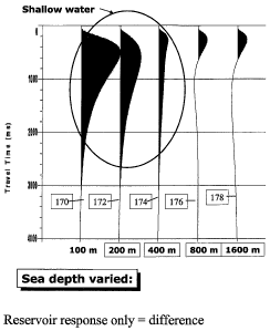
Figure 11 at curves 170, 172, 174, 176 and 178, respectively. The curves in
Figure 11
primarily show the response arising from the resistive feature, because the
sediment and
water layer responses largely cancel in the subtraction.
[00491 Figure 12A shows, respectively, the apparent resistivity response
curves for a
simulation using for no resistive feature (shown by curve 180), and the
response curves
for resistive features located 500 meters below the water bottom, and for a
feature
resistivity of 25 Ohm-meters (shown by curve 182), 50 Ohm-meters (shown by
curve
184), 75 Ohm-meters (shown by curve 186) and 100 Ohm-meters resistive
features.
Figure 12B shows second derivatives of the curves in Figure 12A, at curves
190, 192,
194, 196 and 198, respectively. The effect of change in resistivity of the
resistive feature
can be clearly seen at 190A in Figure 12B.
[0050] Figure 13A shows apparent resistivity response for a 100 Ohm-meter
resistive
layer located at depths of 500 meters (shown by curve 200), 1000 meters (shown
by
curve 202), 1500 meters (shown by curve 204), 2000 meters (shown by curve 206)
and
2,500 meters (shown by curve 208) below the water bottom in the sediment
layer,
respectively. Second derivative curves corresponding to each apparent
resistivity curve
are shown in Figure 13B at curves 210, 212, 214, 216 and 218, respectively.
The
apparent response of the resistive feature is decreased in amplitude and
spread in time as
the resistive feature is moved deeper into the sediment layer.
14
CA 02594762 2007-07-12
WO 2006/091461 PCT/US2006/005410
[0051] The foregoing examples of simulated marine transient electromagnetic
survey are
provided to explain the general concept of the invention, which is to present
t-CSEM data
in a seismic trace format, such that each data trace corresponds to a
particular value of an
acquisition parameter. In all the foregoing examples, the simulated data
correspond to a
transient electric f eld being imparted into the Earth's subsurface, and
measurements
being made of the induced electric field in the Earth's subsurface. It should
be clearly
understood, however, that the principles of the invention are also applicable
to
combinations of transient electric and magnetic fields, and measurements made
therefrom. For example, a transient electric field, induced using a system as
shown in
Figure 1, may have, in addition to or in substitution thereof, measurements
made of the
induced magnetic field, using magnetic field sensors placed at selected
locations along
the sea floor. The magnetic field measurements may be made in directions along
and/or
orthogonal to the direction of the induced electric field. See U.S. Patent No.
U.S. Patent
No. 5,467,018 issued to Rueter et al. Conversely, a magnetic field may be
induced in the
Earth's subsurface by passing electric current through a wire loop. See, for
example,
Strack, K.-M., 1992, Exploration with deep transient eleclromagnetics,
Elsevier, 373 pp.
(reprinted 1999). Induced electric and/or magnetic fields may then be
measured, and
displayed according to any of the foregoing aspects of the invention in order
to infer the
subsurface structure and electrical properties of the Earth formations.
[0052] All of the foregoing examples of marine transient electromagnetic
survey
processing and display techniques used time as the basis for processing and
indexing of
the processed data. It is possible to convert the time indexed processing to
depth indexed
processing by using electrical resistivity data from a wellbore penetrating
the Earth's
subsurface in the vicinity of the transient electromagnetic survey. The
resistivity data
may be obtained by lowering in instrument into the wellbore on the end of an
armored
electrical cable. The instrument may make measurements of electromagnetic
induction
properties and/or galvanic properties of the Earth formations surrounding the
welibore.
A record of the measurements is typically made with respect to depth in the
Earth of the
instrument. The electrical properties with respect to depth may be used to
convert the
time indexed transient electromagnetic measurements to measurements indexed
with
CA 02594762 2007-07-12
WO 2006/091461 PCT/US2006/005410
respect to depth. See, for example, U.S. Patent No. 5,883,515 issued to Strack
et al.,
which discloses a method of determining selected parameters of an earth
formation
surrounding a borehole. The method disclosed includes first, obtaining at
least one
induction logging measurement of the selected parameters in a first
predetermined
volume of the formation surrounding the borehole having known first radial and
vertical
dimensions, then obtaining at least one galvanic logging measurement of the
identical
selected parameters in a second predetermined volume of the formation
surrounding the
borehole having known second radial and vertical dimensions that overlap the
first radial
and vertical dimensions of the first predetermined volume, whereby the
overlapping
volumes form a representative common volume of the formation, and then
combining the
induction and galvanic logging measurements using an inversion technique to
obtain a
measurement of the selected parameters of the earth formation surrounding the
borehole
'in the representative common volume of the formation.
[00531 In some embodiments, the parameter that is varied between individual
traces
maybe determined by sensitivity analysis. Sensitivity analysis may be
performed by
using the forward modeling procedure explained above with reference to Figure
1 through
13B to obtain estimated responses of the particular survey system used to a
model of the
subsurface Earth formations below a water layer of selected depth and
resistivity (both
the foregoing may be taken directly from the actual survey procedure). The
parameters
such as offset, resistive feature thickness, resistive feature depth and
sediment layer
resistivity may be used to determine the parameter that provides the most
change in the
simulated transient response, or most clearly delineates features in the
subsurface.
[0054] From the foregoing examples of voltage response trace presentation and
apparent
resistivity presentation, and differences and second derivatives thereof, it
is believed that
t-CSEM measurements may be processed using well known seismic processing
techniques to infer the presence of and electrical properties of various
features below the
bottom of a body of water. Such processing, display and analysis may make
possible
inference of certain features and properties that were not possible using data
display and
analysis techniques known in the art for processing t-CSEM measurement data.
Finally,
it is believed that data processing and display techniques according to the
invention may
16
CA 02594762 2007-07-12
WO 2006/091461 PCT/US2006/005410
make possible interpretation of CSEM surveys made where the water depth is
less than
about 1.5 to 2.0 times the depth to various target formations or resistive
features in the
Earth's subsurface.
[0055] While the invention has been described with respect to a limited number
of
embodiments, those skilled in the art, having benefit of this disclosure, will
appreciate
that other embodiments can be devised which do not depart from the scope of
the
invention as disclosed herein. Accordingly, the scope of the invention should
be limited
only by the attached claims.
17