Note: Descriptions are shown in the official language in which they were submitted.
CA 02595427 2007-07-19
WO 2006/080997 PCT/US2005/045115
A PATH PLANNER AND METHOD FOR PLANNING A PATH PLAN HAVING A
SPIRAL COMPONENT
Field of the Invention
[0001] This invention relates to a path planner and a method for planning a
path
having a spiral component.
Background of the Invention
[0002] A path planner may be used to determine one or more path plans for a
vehicle to cover a work area. The work area may represent a field for growing
a crop
or other vegetation. The vehicle may need to traverse the entire work area or
a
portion thereof to plant a crop (or precursor thereto), to treat a crop (or
precursor
thereto), to harvest a crop, or to perform another task associated with the
crop or
vegetation, for example. If the path plan is limited to linear rows, the
execution of the
path plan may consume more energy than desired to traverse sloped terrain or
to
cover a given work area in an energy efficient manner. Accordingly, there is a
need
for a system and a method for applying a path plan with a spiral component for
the
vehicle to the work area.
Summary of the Invention
[0003] A method and path planner for planning a path of a vehicle comprises a
perimeter training module for identifying a border of a region associated with
a work
area. A definer defines a reference row having a reference path that tracks at
least a
majority of the border. A generator generates tracking rows that track the
reference
row. The tracking rows comprise at least one outer tracking row and an inner
tracking row. Each inner tracking row has at least one inner curve with a
lesser
radius than an outer curve of an outer tracking row.
Brief Description of the Drawings
[0004] FIG. I is a block diagram of one embodiment of a path planner for
planning
a path of a vehicle incorporated into a vehicle electronics.
[0005] FIG. 2 is a block diagram of a path planner in accordance with the
invention.
CA 02595427 2007-07-19
WO 2006/080997 PCT/US2005/045115
Brief Description of the Drawings
[0004] FIG. 1 is a block diagram of one embodiment of a path planner for
planning
a path of a vehicle incorporated into a vehicle electronics.
[0005] FIG. 2 is a block diagram of a path planner in accordance with the
invention.
[0006] FIG. 3 is a flow chart of a method for creating a path plan having a
spiral
component for a vehicle in accordance with the invention.
[0007] FIG. 4 is a flow chart of another method for creating a path plan for a
vehicle
in accordance with the invention.
[0008] FIG. 5A is a flow chart of yet another method for creating a path plan
for a
vehicle in accordance with the invention.
[0009] FIG. 5B is a flow chart of still another method for creating a path
plan for a
vehicle in accordance with the invention.
[0010] FIG. 6 is a flow chart of a first procedure for handling a pinch region
of the
path plan.
[0011] FIG. 7 is a flow chart of a second procedure for handling a pinch
region of
the path plan.
[0012] FIG. ,8 is a flow chart of a third procedure for handling a pinch
region of the
path plan.
[0013] FIG. 9 is an illustrative path plan formed as an Archimedean spiral.
[0014] FIG. 10 is an illustrative path plan as a modified Archimedean spiral.
[0015] FIG. 11 through FIG. 14, inclusive, are illustrative examples of
various path
plans having spiral components.
[0016] FIG. 15 though FIG. 17, inclusive, are illustrative examples of various
path
plans having spiral components and pinch regions.
[0017] FIG. 18 through FIG. 20, inclusive, are illustrative examples of
forming
tracking rows of a path plan in accordance with a first technique (e.g.,
graduated
technique) in accordance with the method FIG. 8.
[0018] FIG. 21 is an illustrative example of a path plan having a spiral
component
and avoiding obstacles.
[0019] FIG. 22 is a block diagram of an alternate embodiment of a path planner
for
2
CA 02595427 2007-07-19
WO 2006/080997 PCT/US2005/045115
planning a path of a vehicle incorporated into a vehicle electronics.
[0020] FIG. 23 is a f(ow chart of a method for determining whether to use a
linear
path plan or a path plan having a spiral component.
Description of the Preferred Embodiment
[0021] A spiral componentmeans any of the following: (1) a path plan or
contour
rows that follows a generally spiral path, (2) a path plan or contour rows
that
comprises a series of nested loops (e.g., concentric paths or concentric path
rings)
that are interconnected to one another, (3) a path plan or contour rows having
a
continuous curve of variable radius that begins from an outer border and works
inward, and (4) a path plan or contour rows having a continuous curve of
variable
radius from an inner border and works outward.
[0022] In FIG. 1, the path planning system 11 comprises a path planner 10 that
is
coupled to a user interface 21, a location-determining receiver 19, and a
vehicle
controller 16. In turn, the vehicle controller 16 may communicate with one or
more of
the following components: a steering system 20, a braking system 22, a
propulsion
system 24, and a safeguarding system 18.
[0023] The path planner 10 of FIG. 1 comprises a perimeter training module 14
and
spiral region-filling module 12. The path planning system 11 assumes that the
boundary of the work area and each obstacle border has a closed shape. The
perimeter training module 14 is arranged to collect location data on one or
more
points along the perimeter of the work area , stationary obstacles within the
work
area, or a defined region within the work area. For example, the perimeter
training
module 14 may collect location data (e.g., Global Positioning System
coordinates)
from the location-determining receiver 19 (e.g., GPS receiver with
differential
correction). The location data is made available to the spiral region-filling
module 12
or to the reference row definer 26 (FIG. 2).
[0024] The spiral region-filling module 12 establishes a path plan comprising
one or
more spiral components or contour rows to cover the work area or a region
thereof.
Contour rows may be defined by curved components, generally linear components,
3
CA 02595427 2007-07-19
WO 2006/080997 PCT/US2005/045115
or both. Although generally linear rows may be employed as part of a path
plan, the
path plan may be structured to support a spiral path plan to cover a region of
the
work area. For certain regions of a work area, spiral path plans may be more
energy
efficient and reduce fuel consumption over linear rows or other path plans.
Whether
or not spiral rows are more efficient than linear rows may depend upon an
overall
time, fuel consumption, energy consumption for completion of a spiral path
plan
versus a corresponding generally linear path plan.
[0025] The vehicle controller 16 accepts an input of the path plan from the
path
planner 10. The vehicle controller 16 controls the vehicle consistent with the
path
plan, unless the safeguarding system 18 detects an obstacle, obstruction,
hazard, a
safety condition, or another condition that requires the vehicle to depart
from the
planned path, to stop movement or take evasive measures to avoid a collision
with
an object or living being (e.g., a person or animal). The vehicle controller
16 may
generate control signals for a steering system 20, a braking system 22, and a
propulsion system 24 that are consistent with tracking the path plan and
subject to
modification or interruption by the safeguarding system 18. The control
signals may
comprise a steering control signal or data message that defines a steering
angle of
the steering shaft; a braking control signal or data message that defines the
amount
of deceleration, hydraulic pressure, or braking friction to the applied to
brakes; a
propulsion control signal or data message that controls a throttle setting, a
fuel flow,
a fuel injection system, vehicular speed or vehicular acceleration. Further,
where the
vehicle is propelled by an electric drive or electric motor, the propulsion
control signal
may control or modulate electrical energy, electrical current, electrical
voltage
provided to an electric drive or motor. The control signals generally vary
with time as
necessary to track the path plan.
[0026] The steering system 20 may comprise an electrically controlled
hydraulic
steering system, an electrically driven rack and pinion steering, an Ackerman
steering system, or another steering system. The braking system 22 may
comprise
an electrically controlled hydraulic braking system, or another electrically
controlled
friction braking system. The propulsion system 24 may comprise an internal
combustion engine, a internal combustion engine-electric hybrid system, an
electric
4
CA 02595427 2007-07-19
WO 2006/080997 PCT/US2005/045115
drive system, or the like.
[0027] The safeguarding system 18 may comprise an obstacle detection system,
which includes one or more of the following components: an ultrasonic
detector, a
radar device, a laser obstacle detector, a ladar device, a laser range finder,
a vision
obstacle detector, and a stereo vision detector.
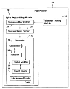
[0028] FIG. 2 is a block diagram of a path planner 10. FIG. 2 shows the path
planner 10 of FIG.- 2 in greater detail than that of FIG. 1. The path planner
10
comprises a spiral region-filling module 12. The spiral region-filling module
12
includes a reference row definer 26, a representation former 28, and a
generator 30.
The reference row definer 26 communicates with the representation former 28.
In
turn, the representation former 28 communicates with the generator 30.
[0029] The definer 26 defines the reference row having a reference contour.
The
reference contour may be defined in accordance with various techniques, which
may
be applied independently and collectively. Under a first technique, the
definer 26
defines the reference row to follow along a boundary contour of a boundary of
the
work area. Under a second technique, the definer 26 defines the reference row
to
follow along a boundary contour of a boundary so that the reference row is
contiguous with the boundary. Under a third technique, the definer 26 defines
a
reference row that tracks around an inner boundary (e.g., about an obstacle or
no-
entry zone) within the work area. In the first and second techniques, the path
plan
may be created to spiral inward toward a central area of the work area,
whereas for
the third technique the path plan may be created to spiral outward.
[0030] The representation former 28 may define spiral components or contour
components of the path plan in accordance with one or more representations.
Regardless of the representation, the spiral component or contour component
may
be defined as a curved component, a generally linear component, or both. Under
a
first representation, the representation former 28 defines the spiral
component, a
contour component, or path plan as a series of interconnected arc segments,
linear
segments, or both. In the first representation, the representation former 28
defines
an arc segment as a center point, a start point, an end point and a radius,
where any
arc segment has a radius greater than the minimum turning radius of the
vehicle.
CA 02595427 2007-07-19
WO 2006/080997 PCT/US2005/045115
The representation former 28 defines the linear segment as two points. Under a
second technique, the representation former 28 may define curved portions or
arc
segments of the path plan in accordance with other definitions or
representations
(e.g., graphical or mathematical representations, or curve equations).
[0031] The generator 30 comprises a coordinator 32, a translator 34 and a
radius
modifier 36 for determining a group of tracking contours or spiral components
that
track a reference contour within a region of a work area. The generator 30
further
comprises a search engine 38 for determining values (e.g., radius values of
curves)
for contour or spiral components and an interference module 40 for resolving
physical interference between candidate or proposed features of the path plan.
The
radius modifier 36 selects the radius difference parameter such that if the
radius
difference parameter generally equals the vehicular width, a nesting solution
applies
to adjacent rows on a local basis.
[0032] In one embodiment, the search engine 38 applies a search algorithm to
possible candidate values of the radius difference parameter, wherein the
search
space is limited such that the radius difference parameter is bounded by a
candidate
radius difference parameter generally equal to or less than the vehicular
width. For
example, the search space is limited such that search is started with the
radius
difference parameter equal to the vehicular width and the radius difference
parameter is decreased therefrom.
[0033] In one embodiment, the interference module 40 identifies the presence
of
two outside curved components (e.g., outside arcs) that are adjacent or
separated by
a linear component in an outer row located toward an outer boundary of the
work
area; the interference module 40 determines a single curved component (e.g.,
outside arc) for an inner tracking row that tracks the outer row. The inner
tracking
row is located closer to an interior of the work area than the outer row. In
another
embodiment, the interference module 40 identifies a presence of an inside
curved
component (e.g., arc) and an outside curved component being adjacent to each
other, in a row where such inside curved component and outside curved
component
would cross over each other; and the interference module 40 applies a
construction
technique (e.g., iterative repair process) to reformulate a potentially
noncompliant
6
CA 02595427 2007-07-19
WO 2006/080997 PCT/US2005/045115
candidate row as a compliant row.
[0034] FIG. 3 illustrates a method for planning a path of a vehicle in
accordance
with the invention. The method of FIG. 4 begins with step S100.
[0035] In step S100, a perimeter training module 14 or path planner 10
identifies a
border of a region associated with a work area. For example, the perimeter
training
module 14 or path,planner 10 may establish or define the border of the region
or the
work area as a series of points (e.g., two dimensional or three dimensional
coordinates). The region may be coextensive with the work area, or a portion
of the
work area.
[0036] In step S102, a definer 26 or path planner 10 defines a reference row
that
has a reference path that tracks at least a majority of the border. In one
example,
the definer 26 or path planner 10 may track a majority of the outside border
once
prior to spiraling. In another example, the definer 26 or path planner 10 may
track a
majority of an inside border (e.g., obstacle located in an interior of the
work area)
prior to spiraling outward.
[0037] In step S104, a generator 30 or path planner 10 generates tracking rows
that track the reference row. For an inward path plan with a spiral component,
each
tracking row comprises an inner tracking row with respect to an outermost row
or
reference row. For an outward path plan with a spiral component, each tracking
row
comprises an outer tracking row with respect to an innermost row or reference
row.
Each inner tracking row has at least one curve with a lesser radius than an
outer
tracking row has. The outer tracking row has a corresponding curve with a
greater
radius than the lesser radius.
[0038] Step S104 may be carried out in accordance with various techniques,
which
may be applied alternatively or cumulatively. Under a first technique, where
the
border comprises an outer border, the generator 30 or path planner 10
generates
tracking rows that track inward from the reference row. Under a second
technique,
the generator 30 or path planner 10 tracks an inner border, the generating of
tracking
rows tracks outward from the reference row. Under a third technique, the
border is
generally circular and the tracking rows form a spiral with a varying radius
that
decreases toward an interior or center of the region.
7
CA 02595427 2007-07-19
WO 2006/080997 PCT/US2005/045115
[0039] Under a fourth technique, step S104 may generate tracking rows with a
desired degree of overlap in accordance with various procedures that may be
applied alternatively or cumulatively. Under a first procedure for the fourth
technique, adjacent rows of spiral and contour patterns may overlap a previous
row
because at least one curved portion or new corners is constrained to use the
vehicle
minimum turn radius when a lesser turning radius would be more desirable to
,maintain a greater spacing between adjacent rows. Under a second procedure
for
the fourth technique, there is no overlap planned between adjacent rows.
Rather,
adjacent spiral rows inside the shape may be nested and constrained by the
radius
of the outside corners. Under a third procedure for the fourth technique, some
overlap is permitted regardless of the vehicle minimum turning radius.
[0040] Under a fifth technique, the path planner 10 or interference module 40
detects corner interactions that prohibit the next contour row (or portion of
the path
plan with a spiral component) from being generated. Generating spiral shapes
(or
portions thereof) may exhibit problems with adjacent curves that cause
problems in
forming a spiral coverage path for some shapes of work areas, such that one or
more of the following compensation techniques may apply: (1) using a spiral
pattern
for the first few rows and reverting to another pattern (e.g., a linear or
contour
coverage pattern) where the efficiency goals are satisfied; (2) issuing a stop
parameter through to signal the path planning of a spiral path plan to stop
when the
spiral rows overlap a previous row by more than some specified maximum amount;
(3) detecting a pinch region of the work area; (4) continuing spiral path plan
generation or execution over the whole work area and then subsequently
performing
special clean-up laps to cover uncovered gaps (e.g., unmowed, untreated or
unharvested gaps) that would be left between adjacent rows (e.g., in certain
turn
areas associated with the corners of the work area); (5) using flip turns in
cases
where the corners dictate a turn distance smaller than a certain threshold;
and (6)
first handling one or more local regions where spiral coverage pattern is
suboptimal
or inefficient by a back-and-forth linear coverage; and second, handling the
remaining regions other than the local regions by executing a path plan having
a
spiral component.
8
CA 02595427 2007-07-19
WO 2006/080997 PCT/US2005/045115
[0041] The method of FIG. 4 may be applied to complement the method of FIG. 3.
The method of FIG. 4 begins in step S106.
[0042] In step S106, the path planner 10 determines whether a border or region
of
the work area is associated with at least one of a circular portion and a semi-
circular
portion (e.g., a generally circular or semi-circular border). The work area
may be
associated with a circular portion or semi-circular portion if a threshold
number of
points conform or lie approximately on a geometric, mathematical or other
representation of a circle, arc or semi-circle. If the border or region of the
work area
is associated with at least one of a circular portion and a semi-circular
portion, then
the method continues with step S107. However, if the border or region of the
work
area is not associated with a circular portion and a semi-circular portion,
then the
method continues with step S100 of FIG. 3.
[0043] In step S107, the path planner 10 or reference row definer 26 defines a
reference row having a reference path that tracks at least one of the circular
portion
and the semi-circular portion. For example, the reference path may track the
border
with one or more overlap or clean-up rows necessary to refine or conform an
irregular semi-circular border or circular border into a generally regular
form,
consistent with the definitions of semi-circle, circle or arc.
[0044] In step S103, the path planner 10 or generator 30 generates tracking
rows
that track the reference row to form a set of arcs or a variable radius arc
inward from
at least one of the circular portion and semi-circular portion. The tracking
rows
comprise at least one inner tracking row and an outer tracking row. Each inner
tracking row has at least one curve with a lesser radius than an outer
tracking row
having a corresponding curve with a greater radius. For example, the variable
radius arc is defined in accordance with the following equation:
[0045] Arc radius = a x theta, where a is the initial radius or outer radius
of the work
area (or the refined border) and wherein theta is a variable that reduces the
initial
radius as a function of angular displacement along a path and inward toward a
central area of the region.
[0046] FIG. 5A shows a method that may be applied following the method of FIG.
3
or FIG. 4. The method of FIG. 6 begins in step S110. Like reference numbers in
9
CA 02595427 2007-07-19
WO 2006/080997 PCT/US2005/045115
FIG. 5 and FIG. 3 indicate like elements.
[0047] Step S110, may be integrated into step S100 or performed, before, after
or
during step S100. In step S110, path planner 10 identifies a border of a
region
associated with a work area and one or more corners associated with the border
of
the region.
[0048] In step S102, a definer 28 or path planner 10 defines a reference row
that
has a reference path that tracks at least a majority of the border. The
description of
step S102 set forth in conjunction with FIG. 2 applies equally here to FIG.
5A.
[0049] In step S104, a generator 30 or path planner 10 generates tracking rows
that track the reference row. The tracking rows comprise at least one inner
tracking
row and an outer tracking row. Each inner tracking row has at least one curve
with a
lesser radius than an outer tracking row has. The outer tracking row has a
corresponding curve with a greater radius that than the lesser radius. The
various
techniques for executing step S104 in FIG. 3 apply equally to FIG. 5 as if
fully set
forth herein.
[0050] In step S112, a generator 30 or path planner 10 establishes a virtual
boundary extending diagonally from the identified corner or corners to an
interior
region of the region (e.g., work area).
[0051] In step S113, a generator 30 or path planner 10 plans a turn between
tracking rows along or in a vicinity of the virtual boundary. For example, the
path
planner 10 may plan a flip turn in which the vehicle switches or reverses
direction
such that the vehicle is heading in substantially opposite direction in an
subsequent
row with respect to a previous row. The flip turn may be executed such that
the
vehicle returns along an adjacent row that is generally parallel to an
immediately
previously executed row. Alternatively, the flip turn may be implemented such
that
one or more intervening rows are skipped while making the flip turn.
[0052] The method of FIG. 5B is similar to the method of FIG. 5A, except the
method of FIG. 5B replaces steps S112 and S113 with steps S188 and S190. Like
reference numbers in FIG. 5A and FIG. 5B indicate like steps or procedures.
Because steps S110 and S102 have already been described in conjunction with
FIG.
5A, the explanation here will start with step S188.
CA 02595427 2007-07-19
WO 2006/080997 PCT/US2005/045115
[0053] In step S188, the generator 30 or path planner 10 generates a series of
nested loops spaced apart from each other by a generally uniform spacing
(e.g.,
vehicle width). At least one of the nested loops tracks the reference row.
Where the
reference row is the outermost row associated with a border of the work area,
the
next inner loop tracks the outermost row. Where the reference row is the
innermost
row associated with the border of an obstacle in a central portion of the work
area,
the next outer loop tracks the innermost row. The~generally uniform spacing
may
comprise a vehicle width, an implement width, a cutting width, a swath, an
operation
width or the like. Further, the generally uniform spacing may include an
offset or
overlap allowance between adjacent nested loops.
[0054] In step S190, the generator 30 or path planner 10 links a series of
nested
loops to one another by moving transversely (e.g., inward or outward) to a
portion of
a nested loop between the identified corner and a central area of the region
or work
area. The vehicle may make more gradual or maneuverable turns where the
transverse movement occurs along the virtual boundary between the identified
corner and a central area, as opposed to requiring the transverse movement
along
other portions of the nested loops.
[0055] FIG. 6 shows a method that may be applied following the method of FIG.
3
or FIG. 4. The method of FIG. 6 begins in step S114.
[0056] In step S114, a pinch detector or interference module 40 detects a
pinch
region in a tracking row associated with a loop in a path plan. A pinch region
refers
to a narrow region or bottleneck in the work area in which a spiral path plan
is
constrained or prevented from realization. For example, the narrow region may
be
present because of a natural features, topographical features, land ownership
boundaries, geopolitical boundaries, or other particular boundaries of the
work area.
[0057] In step S116, the generator 30, path planner 10, or interference module
40
defines a cross-over row at the pinch region over which the vehicle may travel
multiple times to service area on each side of the pinch region within the
work area.
For example, each complete lap (e.g., spiral) of the path plan may cross the
pinch
region twice, until all laps have been completed. Uncovered or remnant areas
on
either side of the pinch region may be covered by back and forth linear
sweeps.
11
CA 02595427 2007-07-19
WO 2006/080997 PCT/US2005/045115
[0058] FIG. 7 shows a method that may be applied following the method of FIG.
3
or FIG. 4. The method of FIG. 7 may be applied as an alternative to that of
FIG. 6.
The method of FIG. 7 begins in step S114.
[0059] In step S114, a pinch detector or interference module 40 detects a
pinch
region in a tracking row associated with a loop in a path plan. A pinch region
refers
to a narrow region or bottleneck in the work area in which a spiral path plan
is
constrained or prevented from realization. 'For example, the narrow region may
be
present because of a natural features, topographical features, land ownership
boundaries, geopolitical boundaries, or other particular boundaries of the
work area.
[0060] In step S120, a generator 30, a path planner 10, or an interference
module
40 defines a first coverage area on a first side of the pinch region and a
second
coverage area on a second side of the pinch region.
[0061] In step S122, the generator 30 or path planner 10 applies a first
spiral path
plan to the first side and a second spiral path plan to a second side. For
example,
the path plan comprises first completing a first spiral path plan or firth
path plan
having a spiral component; second, crossing over the pinch area from the first
side
to the second side; and third, completing a second spiral path plan or second
path
plan having a spiral component on the second side.
[0062] The method of FIG. 8 is similar to the method of FIG. 7, except step
S124
and S126 of FIG. 8 collectively replace step S122 of FIG. 7. The method of
FIG. 7
begins with step S114. Like reference numbers in FIG. 7 and FIG. 8 indicate
like
elements.
[0063] In step S114, a pinch detector or interference module 40 detects a
pinch
region in a tracking row or loop associated with a loop in a path plan. A
pinch region
refers to a narrow region or bottleneck in the work area in which a spiral
path plan is
constrained or prevented from realization. For example, the narrow region may
be
present because of a natural features, topographical features, land ownership
boundaries, geopolitical boundaries, or other particular boundaries of the
work area.
[0064] In step S120, a generator 40, a path planner 10, or an interference
module
40 defines a first coverage area on a first side of the pinch region and a
second
coverage area on a second side of the pinch region.
12
CA 02595427 2007-07-19
WO 2006/080997 PCT/US2005/045115
[0065] In step S124, a generator 10 or path planner 10 forms a series of
nested
loops spaced apart from one another by a generally uniform spacing (e.g.,
vehicle
width, the nested loops defining the tracking rows). The generaliy uniform
spacing
may comprise one or more of the following: vehicle width, vehicle width less
an
overlap allowance, implement width, implement width less an overlap allowance,
cutting width, swath, harvesting width, spraying width, distribution width, or
treatment
width, and cutting width, swath, harvesting width, spraying width,
distribution width,
or treatment width, less an overlap allowance. Step S124 may be carried out by
forming a first series of nested loops for the first coverage area and forming
a
second series of nested loops for the second coverage area.
[0066] In step S126, the generator 10 or path planner 10 links one nested loop
to
another nested loop to interconnect the nested loops. For example, the linking
is
accomplished by moving transversely inward to the nested loops toward a
central
area of the region.
[0067] FIG. 9 illustrates work area or region of the work area that has a
generally
circular portion, consistent with step S106 of FIG. 4. Here, because the work
area is
generally circular, an Archimedean spiral may be used to cover the work area
with
no or minimal overlap between radially spaced curved portions (e.g., adjacent
contour rows) of the spiral. Archimedean spirals generally have a generally
uniform
or constant spacing (e.g., vehicular width) of the rows throughout the spiral
pattern.
However, strict adherence to the Archimedean spiral shape may cause a greater
than the ideal amount of overlap in the outermost two laps of the path plan.
The
Archimedean spiral of FIG. 9 may have a radius that is consistent with the
following
equation. Radius = a * theta. Although FIG. 9 illustrates the starting point
900 of the
path plan on an outer boundary of the work area 932 or region and a
termination
point 901 in a central area of the work area 932, the vehicle may start the
path plan
at a center of the work area or region, as an alternative. For example, the
path plan
may be established from the starting point 900 to the termination point 901
where the
path plan with the spiral component proceeds inwardly, or vice versa where the
path
plan with the spiral component proceeds outwardly. For the case where the
vehicle
starts from the outer boundary, the vehicle may follow the entire boundary
shape
13
CA 02595427 2007-07-19
WO 2006/080997 PCT/US2005/045115
before it starts to spiral inward to ensure that there is no missed area of
the work
area.
[0068] FIG. 10 illustrates work area 934 or region of the work area that
includes two
generally semi-circular portions 936, consistent with step S106 of FIG. 4.
Here, an
Archimedean spiral or another spiral configuration may be used to cover the
work
area with no or minimal overlap between radially spaced curved portions of the
spiral. Although FIG. 10 illustrates the starting point 902 of the path plan
on an outer
boundary of the work area or region, the vehicle may start the path plan at a
center
of the work area or region from the termination point 903, as an alternative.
For
example, the path plan may be established from the starting point 902 to the
termination point 903 where the path plan with the spiral component proceeds
inwardly, or vice versa where the path plan with the spiral component proceeds
outwardly.
[0069] Path plans with spiral components in FIG. 11 through FIG. 14 are
representative of path plans with virtual boundaries 908 of step S112 of FIG.
5A and
turns of step S113 of FIG. 5A. The virtual boundaries 908 of FIG. 11 through
FIG.
14 may be described as generally oval shapes (e.g., finger-like shapes) that
extend
diagonally between a corner 938 and an interior or central area 940 of the
work area.
In one embodiment, the generally oval shapes coincide with paths which
represent
clean-up laps that are required because the path plan with spiral components
(e.g.,
nested arcs or minimum turn arcs) tend to leave a gap (e.g., uncut, unmowed,
unharvested or untreated vegetation, which is sometimes shaped like partial
moon)
between the previous rows.
[0070] In an alternative embodiment, the generally oval clean-up lap may be
replaced by one or more flip turns in region of the virtual boundary 908. For
example, flip turns may be executed in the innermost rows of the path plan.
Flip
turns (e.g., approximately 180 degree turns) allow the vehicle to turn back on
the
next row without skipping any rows or intermediate rows.
[0071] Each of the path plans with spiral components shown in FIG. 11 through
FIG. 14, inclusive, includes a starting point 950 and a termination point 951.
Although the path plans begin at the starting point 950 toward an outer
boundary of
14
CA 02595427 2007-07-19
WO 2006/080997 PCT/US2005/045115
the work area and move inwardly toward a central area 940, in an alternate
embodiment any of the path plans may begin at the termination point 951 and
move
outwardly toward an outer boundary of the work area (e.g., toward the starting
point
950). If an obstacle is present in the central area 940, an inner boundary of
the work
area may be coextensive with a zone boundary of an obstacle clearance zone
about
the obstacle.
[0072] The path plans in FIG. 15 through FIG. 17 show partially complete or
incomplete path plans which have pinch regions 888. The pinch regions 888 of
FIG.
15 through FIG. 17 are illustrative of potential pinch regions set forth in
step S114 of
FIG. 6, FIG. 7, and FIG. 8. In general, a spiral may be subject to a pinch
region
(e.g., 888), if a shape of a work area (e.g., figure-eight shaped) or a region
thereof is
susceptible or conducive to such pinching. When a spiral path plan pinches, it
may
produce discontinuities, or awkwardness in the path plan that could
potentially leave
large uncovered areas for a spiral path plan or a path plan having a spiral
component. Although the partial path plans with the spiral components in FIG.
15
through FIG. 17 are linked by links 890 or transverse portions to move from
one
nested loop 992 to another nested loop 994, other configurations of the path
plans
are possible, such as continuous spiral path plans as disclosed elsewhere
herein.
[0073] There are various ways to handle a pinch region in planning an
acceptable
resultant path plan. Under a first technique, the path planner 10 forms a path
plan
that crosses over the pinch location on multiple passes (e.g., continually) to
move
from a first area on one side of the pinch region to a second area on another
side of
the pinch region. The cross-over technique is referenced in step S116 of FIG.
6.
[0074] Under a second technique for handling a pinch region, the path planner
10
makes new sub-path plans out of the areas associated with the pinch region and
starts a new spiral path plan in each area. For example, the path planner 10
may
establish a first spiral plan to a first side of the pinch region and a second
spiral plan
for a second side of the pinch region. Refer to FIG. 15 through FIG. 17 to see
an
illustrative example of the first side (e.g., first side 996) and the second
side (e.g.,
second side 998). Further, where the vehicle generally remains on a first side
until
completion of the first spiral plan and then moves through the pinch region to
focus
CA 02595427 2007-07-19
WO 2006/080997 PCT/US2005/045115
on the second spiral plan. The second technique may be referred to as a
sequential
side execution technique. The sequential side execution technique is described
in
conjunction with step S122 of FIG. 7.
[0075] Each path plans in FIG. 18 through FIG. 20 comprises a series of nested
contours or nested loops 333. The starting points 345 and termination points
347
are labeled. Although the order of execution of the path plan generally
extends from
the starting point 345 to the termination point 347, it may be reversed such
that any
path plan begins from the termination point 347 and ends with the starting
point 345.
The contours or nested loops range from an innermost contour or innermost loop
335 to an outermost contour or outermost loop 337. Each inner contour is
linked to
an adjacent contour by a transition link. Each transition link 339 is
transverse or
generally perpendicular with respect to its nested contour or loop 333. The
path
plans of FIG. 18 through FIG. 20 are consistent with the path plan of FIG. 5B
and
with step S126 of FIG. 8. However, it should be noted that the path plan of
FIG. 18
is only partially complete as shown in FIG. 18. The unfilled regions of the
path plan
with the spiral component may be filled by a spiral component in a first
region 341
and a linear coverage plan in a second region 343.
[0076] The path plans of FIG. 18 through 20 are applicable to irregular shaped
regions as in FIG. 18, generally triangular regions as in FIG. 19, and
generally
rectangular regions as in FIG. 20, for example. The path planner may form any
path
plan of FIG. 18 through FIG. 20 by using an outer boundary as the template and
spacing loops inward from the outer boundary by successive multiples of
generally
uniform spacing (e.g., vehicle widths, track widths, vehicle widths less an
overlap
allowance, or track widths less an overlap allowance) until the final central
area is
reached where insufficient room for a loop exists or the vehicle minimum
turning
radius is unable to execute the next loop (e.g., inward from the innermost
loop). The
final central area (e.g., unmowed, unharvested or untreated area) that is left
inside a
spiral pattern may be covered using a back-and-forth sweep pattern as part of
the
path plan having a spiral component. For example, the path planner 10 may
select
the longest side, linear segment or curved portion of final central area as
the
reference line or contour. The other rows of the back-and-forth sweep pattern
are
16
CA 02595427 2007-07-19
WO 2006/080997 PCT/US2005/045115
generally tracking or parallel to the reference line or contour.
[0077] FIG. 21 is an illustrative example of a path plan having a spiral
component
and avoiding internal obstacle areas. The path plan of FIG. 21 is similar to
the path
plan of FIG. 20, except for the obstacles. Where the obstacles are present,
the path
plan turns. Each turn to avoid striking an obstacle may result in the
vehicle's tracking
adjacent rows in, generally opposite directions. The rows illustrated in FIG.
20 do not
require generally~oval clean-up laps and flip turn as previously illustrated.
[0078] The path plan is composed of a series of nested loops, that are
interconnected with interconnection links. The nested loops may be spaced
apart by
a generally uniform spacing (e.g., the vehicle width, the task width, the
vehicle width
less an overlap allowance, or the task width less an overlap allowance). The
interconnection links may be found along a virtual boundary that extends
diagonally
from the corner to an interior region of the work area.
[0079] In FIG. 21, the vehicle may start on the outside border of the work
area and
spirals inward until the next spiral row cannot be created. At this point in
the central
area, the coverage solution finishes the inside area using a back and forth
sweep
pattern. This example also has a number of internal obstacles. The work area
of
FIG. 21 contains a number of obstacles 777. Each obstacle 777 is surrounded by
an
obstacle clearance zone 779 into which a turn may occur so long as the
obstacle
777 is not impacted, contacted or struck. The obstacle clearance zone 779 is
associated with a zone boundary 781, which is coextensive with an outer
perimeter
or outer periphery of the corresponding obstacle clearance zone 779 about a
respective obstacle 777. Here, the zone boundary 781 is shown as one or more
dashed lines.
[0080] The path planning system 111 of FIG. 22 is similar to the path planning
system 11 of FIG. 1, except that path planning system 111 of FIG. 22 comprises
a
path planner 110 that includes a linear path estimator 51, a spiral path
estimator 53,
a turn estimator 55, and a data processor 57 for supporting the determination
of
whether to use a linear path plan or a path plan with a spiral component
(e.g., a
spiral path plan) to service a defined work area. The linear path estimator 51
estimates a linear length (or linear time duration) for covering a work area
with a
17
CA 02595427 2007-07-19
WO 2006/080997 PCT/US2005/045115
linear coverage path. In contrast, the spiral path estimator 53 estimates a
spiral
length (or spiral time duration) for covering a work area with a spiral
coverage path.
The turn estimator 55 estimates the length (or duration) of turns for end rows
to
cover the work area for the linear coverage path and the spiral coverage path.
The
data processor 57 adds the length of turns for the linear coverage pattern to
the
linear length to obtain a first total length and the length of turns for the
spiral
coverage pattern to the spiral length to obtain the second total length. The
data
processor 57 determines the shorter of the first total length or the second
total length
to assign a corresponding preferential path plan as the linear path plan or
the spiral
path plan. In an alternate embodiment, the data processor 57 determines the
lesser
of the first total time associated with the linear coverage path and the
second total
time associated with the spiral coverage path, where first total time
comprises the
linear time duration plus the appropriate turn time duration and the second
total time
comprises the spiral time duration plus the appropriate turn time duration.
The data
processor 57 may apply or recommend (e.g., via the user interface 21) a spiral
path
plan, a linear path plan, or both to cover a particular work area. The work
area may
be defined by the perimeter training module 14.
[0081] FIG. 23 is a method for determining whether to use a linear path plan
or a
spiral path plan. The method of FIG. 23 begins with step S300.
[0082] In step S300, a linear path estimator 51 estimates a linear path
estimate of
at least one of a total length (in distance), a total elapsed time, and a
total energy
consumption for a vehicle to execute a linear coverage path that covers the
region
(e.g., work area). For example, the path estimator 51 estimates the total
length or
total elapsed time for the vehicle to traverse the linear path segments that
cover the
region (e.g., work area). For a linear coverage pattern, back and forth sweeps
produce generally parallel straight lines that covers the work area. The
estimator
considers vehicular constrains such as turning radius, maximum speed, energy
consumption, and the like.
[0083] In step S302, the turn estimator 55 estimates a first turn estimate of
at least
one of a total length, a total time, and a total energy consumption associated
with the
turns at the end of rows, turns for avoiding obstacles, or both of the
generally linear
18
CA 02595427 2007-07-19
WO 2006/080997 PCT/US2005/045115
path plan. For example, the turn estimator 55 estimates the elapsed time for
the
vehicle to complete all of the turns (e.g., end of row turns) that support the
linear
coverage path of step S300. Under one procedure for carrying out step S302, a
turn
estimator estimates the number of turns (e.g., end row turns) required to
support the
linear coverage path plan and then converts the number of turns into a total
turn
length, a total turn time, and a total turn energy consumption.
[0084] In step S304, a data processor 57 determines a first figure of merit
for a
corresponding linear coverage path that covers the work area. The first figure
of
merit may be determined by adding the linear estimate to the corresponding
first turn
estimate. In one example, the first figure of merit comprises a total
estimated energy
consumption for a particular vehicle to complete a corresponding particular
linear
coverage path, which includes traversing the linear segments of step S300 and
the
turns of step S302. In another example, the first figure of merit comprises a
total
estimated time duration for a particular vehicle to complete a corresponding
particular linear coverage path, which includes traversing the linear segments
of step
S300 and the turns of step S302. In another example, the first figure of merit
comprises a total estimated length for a particular vehicle to complete a
corresponding particular linear coverage path, which includes traversing the
linear
segments of step S300 and the turns of step S302.
[0085] In step S306, a spiral path estimator 53 estimates a spiral path
estimate of
at least one of a total length (in distance), a total elapsed time, and a
total energy
consumption for a vehicle to execute a spiral coverage path for a region. For
example, the spiral path estimator 53 estimates the total length or total
elapsed time
for the vehicle to traverse the contour or spiral path segments that cover the
region.
For a curved coverage region, contour sweeps cover a region with adjacent
curved
paths. Such paths resemble the patterns of contour lines found on a map of a
hill
slope. The estimator 53 considers vehicular constrains such as turning radius,
maximum speed, energy consumption, and the like.
[0086] In step S308, the turn estimator 55 estimates a second turn estimate of
at
least one of length, time duration and energy consumption associated with one
or
more of the following turns: the requisite number of turns for ends of rows
(if
19
CA 02595427 2007-07-19
WO 2006/080997 PCT/US2005/045115
required), the requisite number of turns for linking between nested loops (if
required),
turns for the requisite number of awaiting one or more obstacles (if
required), the
requisite number of flip turns (if required) and the requisite number other
turns for the
estimated spiral path of step S306. For example, the turn estimator 55
estimates the
elapsed time for the vehicle to complete the turns (if any) that support the
spiral
coverage path of step S306. Under one procedure for carrying out step S308, a
turn
bstimator estimates the number of turns (e.g., end row turns) required to
support the
spiral coverage path plan and then converts the number of turns into a total
turn
length, a total turn time, and a total turn energy consumption.
[0087] In step S310, a data processor 57 determines a second figure of merit
for a
corresponding spiral coverage path. The second figure of merit may be
determined
by adding the spiral path estimate to the corresponding second turn estimate.
In one
example, the second figure of merit comprises a total estimated energy
consumption
for a particular vehicle to complete a corresponding particular spiral
coverage path,
which includes traversing the spiral segments of step S306 and the turns of
step
S308. In another example, the second figure of merit comprises a total
estimated
time duration for a particular vehicle to complete a corresponding particular
spiral
coverage path, which includes traversing the linear segments of step S306 and
the
turns of step S308. In yet another example, the second figure of merit
comprises a
total estimated energy consumption of the vehicle to complete a corresponding
particular spiral coverage path, which includes traversing the linear segments
of step
S306 and the turns of step S308.
[0088] In step S312, the data processor 57 determines whether to select the
linear
path or the spiral coverage path based on the determined first figure of merit
in step
S304 and the second figure of merit of step S310. If the second figure of
merit is
superior to the first figure of merit, then the data processor 57 may select
the spiral
coverage path as the preferential coverage path. For example, the data
processor
57 may select a preferential path with the shortest length, shortest time or
the lowest
energy consumption based on the determined first figure of merit in step S304
and
second figure of merit of step S310. The preferential path may be the spiral
path
plan, but need not be.
CA 02595427 2007-07-19
WO 2006/080997 PCT/US2005/045115
[0089] Under certain circumstances, the spiral coverage path for area coverage
has efficiency or energy consumption advantages over simple parallel straight
lines
or a linear coverage path. For example, when the contours of the spiral run
adjacent to a long side of the region to be covered, the spiral coverage
pattern tends
to minimize the number of required linking turns, turns between rows, or flip
turns,
which reduces the time needed to complete the operation. Additionally, by
maximizing the length of the rows, missed areas are minimized and overlapping
between rows can be minimized. The first figure of merit and the second figure
of
merit are intended to capture the efficiency or energy consumption advantages
noted
above and to support analysis thereof.
[0090] Although it is preferable that the reference contour is chosen such
that the
energy consumption for completion of the resultant coverage path will be
minimized
in accordance with the method of FIG. 23 or another technique, the user may
select
a contour reference path for other reasons independent of FIG. 23 or any
comparison to corresponding linear paths for a region.
[0091] The path plan and method having a spiral, component supports spiral
sweeps for covering an area to enhance the efficiency of the vehicle
operator's work
tasks. In accordance with the path plan with the spiral component, the vehicle
may
start on the border of a shape and work its way inward until the work area has
been
covered, or vice versa. Spiral coverage paths are used to minimize the number
of
end-of-row turns that might otherwise occur for a coverage pattern with linear
rows.
The reduction or minimizing the number of end-of-row turns (over those
required for
a coverage pattern with generally linear rows) increases the efficiency of the
vehicle
and the overhead (e.g., reduction of operating hours, fuel consumption, and
labor
costs) of an operation. The vehicle and operator spends a greater portion of
its total
time working in the work area to be covered, instead of turning around for the
next
row.
[0092] The starting point and end point of any spiral path plan may be
opposite or
transposed for the path planning phase versus the path execution phase in any
embodiment disclosed herein. For example, any path planning method disclosed
herein may work inward from a reference contour (e.g., outer boundary of the
work
21
CA 02595427 2007-07-19
WO 2006/080997 PCT/US2005/045115
area) to complete the path plan. However, the inwardly-formed spiral path plan
may
be subsequently executed by a vehicle in the reverse order, from inward to
outward.
[0093] Having described the preferred embodiment, it will become apparent that
various modifications can be made without departing from the scope of the
invention
as defined in the accompanying claims.
22