Note: Descriptions are shown in the official language in which they were submitted.
CA 02603296 2013-05-27
- 1 -
DESIGN OF SURVEYS USING CONTROLLED SOURCE ELECTROMAGNETIC FIELDS
FIELD OF THE INVENTION
[0002] This invention relates generally to the field of geophysical
prospecting,
and more particularly to, the field of controlled-source electromagnetic
("CSEM")
surveying. Specifically, the invention is a method for designing a
reconnaissance
survey for CSEM exploration of a subterranean region, and interpreting the
results.
BACKGROUND OF THE INVENTION
[0003] Because reconnaissance CSEM surveys must be designed in the
absence of any information about specific targets, that being what is meant by
the
term "reconnaissance," methods used for designing traditional target-oriented
CSEM
surveys are inapplicable. In addition, because the interpretational objectives
and prior
information are different from target-oriented CSEM surveys, a different
interpretation approach is needed.
[0004] Target-oriented CSEM surveys are currently directed towards one or
more specific targets that have been identified and characterized using prior
information, such as 3D seismic data. Design and interpretation of these
surveys is
guided by this prior information (Kong et al., "Seabed logging: A possible
direct
hydrocarbon indicator for deepsea prospects using EM energy, Oil and Gas
Journal,
30-38 (May 13, 2002)). In reconnaissance CSEM surveying, the specific target
parameters may not be available and usually only general geological
information is
known. The few attempts at designing reconnaissance CSEM surveys concentrated
on improving resolution and accuracy. See Maurer et al., "Optimized and robust
experimental design: a non-linear application to EM sounding," Geoph. J Int.
132,
458-468 (1998); and Singh et al., "Effective skin depth with a local source
and its
application to survey design and data inteipretation," 72nd Ann. Internat. Mg;
Soc. of
CA 02603296 2007-10-02
WO 2006/115622 PCT/US2006/009931
- 2 -
ExpL Geophys., 684-687 (2002). The equipment vendors offer cheaper tools to
cover
large areas (usually in regular grid) at reduced costs. See Eaton et al.,
"NEWTEM - A
novel time-domain helicopter electromagnetic system for resistivity mapping,"
72nd
Ann. Internat. Mfg: Soc. of ExpL Geophys., 1-4 (2002). Other writers suggested
an
approach to survey design based on global minimization where the objective
function
includes the measure of optimal resolution and penalizes the survey cost
through the
number of required measurements (Maurer et al., "Geophysical survey design:
Get the
most for the least!" 68th Ann. Internat. Mfg: Soc. of ExpL Geophys., 78-81
(1998)).
There is a need for a method that can evaluate a proposed reconnaissance
survey of a
particular design, and allow comparison of different survey designs on an
expected
value basis. The present invention satisfies this need.
SUMMARY OF THE INVENTION
[0005] In one embodiment, the present invention is a method for
evaluating a
proposed design for a geophysical survey of a subsurface region, comprising
the steps
of (a) obtaining existing geologic and economic information about the
subsurface
region and about potential target formations therein; (b) simulating a
plurality of
calibration surveys of the subsurface region, using the existing geologic
information
and the proposed survey design, each simulated survey assuming target
properties
consistent with the existing information but otherwise random; (c) using the
simulated
calibration survey results and the existing economic information to train a
selected
classifier algorithm to convert the results of a survey into an indicator of
presence of
economic size targets; (d) simulating a plurality of decision surveys of the
subsurface
region, using the existing geologic information and the proposed survey
design, each
simulated survey assuming target properties consistent with the existing
information
but otherwise random; (e) applying the trained classifier to the results of
each of the
plurality of simulated decision surveys, generating an indicator of likelihood
that such
survey contains at least one economic target; (f) selecting a threshold value
for the
target indicator based on a count of correct indications of at least one
economic target
and a count of incorrect indications of at least one economic target from said
plurality
of simulated decision surveys; and (g) calculating an expected value for a
geophysical
survey based on the proposed survey design, using probabilities derived from
said
CA 02603296 2007-10-02
WO 2006/115622 PCT/US2006/009931
- 3 -
count of correct indications and said count of incorrect indications
corresponding to
the selected threshold indicator value.
[0006] In some embodiments of the invention, the geophysical survey is
a
controlled source electromagnetic survey, and the simulating steps comprise:
(a)
converting said existing geologic information into a set of target property
probability
distributions, including a distribution of the number of targets in the
subterranean
region; (b) randomly drawing a set of target properties from said target
property
distributions; (c) placing a target at a random location in the subterranean
region; (d)
repeating steps (b)-(c) until the drawn number of targets have been placed;
(e)solving
Maxwell's field equations to develop a sensitivity map database, each map
giving an
anomalous electromagnetic response at a central receiver location for a
representative
array of nearby target positions thereby showing receiver sensitivity to
relative target
position, said database comprising a map for each of a representative set of
target
properties and for source properties including at least one source frequency
from the
proposed survey design; (f) selecting at least one sensitivity map matching
the target
properties of one target placed in the subterranean location in a previous
step; (g)
extracting the electromagnetic response from the selected sensitivity map, or
interpolating from two maps, for a plurality of relative target-to-receiver
locations;
and (h) repeating steps (f)-(g) for each additional target placed in the
subterranean
location, thereby generating a map database of simulated anomalous
electromagnetic
responses observed at each receiver due to all placed targets.
[0007] The trained classifier of the present invention may also be
used to
evaluate the results of an actual survey.
BRIEF DESCRIPTION OF THE DRAWINGS
10008] The present invention and its advantages will be better
understood by
referring to the following detailed description and the attached drawings in
which:
Fig. 1 is a decision tree for Value of Information analysis of survey designs;
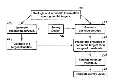
Fig. 2 is a flow chart of the basic steps of one embodiment of the invention;
CA 02603296 2013-05-27
- 4 -
Fig. 3 is a flow chart showing the basic steps in a survey simulation;
Figs. 4a-4c illustrate electromagnetic modeling for sensitivity maps; Fig. 4a
shows the modeled field with target present, Fig. 4b shows the anomalous
field, and
Fig, 4c shows the anomalous field expressed as a fraction of the peak field;
Figs. 5a-c are sensitivity maps for source frequencies of 0.0625 Hz (Fig. 5a),
0.125 Hz (Fig. 5b), and 0.25 Hz (Fig. 5c);
Fig. 6 is a flow chart showing steps for detecting economic-size targets;
Figs. 7a and 7b are location maps illustrating two simulated target steps;
Figs. 8a and 8b are anomalous response maps for simulated surveys with
target locations given by Figs. 7a and 7b, respectively;
Fig. 9 illustrates economic and uneconomic responses from a calibration data
set;
Figs. 10a and 10b are maps showing economic target probabilities estimated
from the anomalous responses of Figs. 8a and 8b, respectively; and
Fig. 11 shows receiver output characteristic ("ROC") curves for two survey
designs,
100091 The invention will
be described in connection with its preferred
embodiments. However, to the extent that the following detailed description is
specific to a particular embodiment or a particular use of the invention, this
is
intended to be illustrative only. On the contrary, it is intended to cover all
alternatives,
modifications and equivalents. The scope of the claims should not be limited
by the
embodiments set out herein but should he given the broadest interpretation
consistent with
the description as a whole.
CA 02603296 2007-10-02
WO 2006/115622 PCT/US2006/009931
- 5 -
DETAILED DESCRIPTION OF THE PREFERRED EMBODIMENTS
[0010] The invention applies a technique called Value of Information
("VOI")
analysis (see chapter 10 in Newendorp, Decision Analysis for Petroleum
Exploration,
PennWell Publishing (1975)) to CSEM survey design. The inputs are a set of
candidate survey designs, and general geologic information about the
electromagnetic
targets that might be present in the survey area. Some of these targets might
represent
economic accumulations of hydrocarbons, while others are too small to be
economic,
even if they contain hydrocarbons. The basic output is an economic value for
each
survey design that depends on its ability to distinguish between economic and
uneconomic targets. The survey design that delivers the highest value, after
accounting for the survey cost, is the one that should be used.
[0011] The objective of a reconnaissance CSEM survey is to decide
whether
further, higher cost exploration activities, such as acquiring 3D seismic
data, should
be pursued in the survey area. If the outcome of the reconnaissance survey is
sufficiently favorable for the presence of an economically viable hydrocarbon
accumulation, additional data gathering and analysis is justified. According
to VOI
principles, a survey design should be selected based on its ability to reduce
the
uncertainty in this decision.
[0012] Figure 1 shows a VOI decision tree for the survey design
problem.
The rectangles in Figure 1 represent decisions. The process begins at the left
side of
the tree, trying to decide between competing survey designs D1 and D2. (The
branch
for design D2 looks the same as the D1 branch, so it is not shown in the
figure.) For
simplicity, only two designs are shown in the tree, but the analysis applies
to any
number of candidate designs. Typically, there are only a limited number of
operationally practical designs that need to be considered.
[0013] Based on the general geologic information that is currently
available,
the survey area is assigned a probability PEcoAT of containing an economic-
size target.
The fact that a reconnaissance survey is under consideration implies that
PECON is low,
so the decision about whether to pursue exploration in the survey area is
risky. The
CA 02603296 2007-10-02
WO 2006/115622 PCT/US2006/009931
- 6 -
results of the survey can reduce the risk either by increasing P EcoN, making
it more
likely that subsequent information will find an economic hydrocarbon
accumulation,
or by decreasing P ECON, making it less likely that a viable prospect is being
abandoned.
[0014] The results of a reconnaissance CSEM survey depend on the
survey
design and on the unknown distribution of targets in the survey area. For
simplicity,
the range of possible results is represented as two branches in Figure 1 ¨ a
"Favorable" outcome that results in higher probability of an economic target P
BETTER,
and an "Unfavorable" outcome that results in a lower probability P WORSE.
Because the
actual outcome is unknown, both possibilities have to be considered. If the
result is
the favorable outcome, the user of the method will decide whether to pursue
exploration based on the new, higher probability P BETTER. If P BETTER is high
enough,
the user will decide to pursue exploration, and the expected economic value of
the
survey area will be PBETTER*SEV - $C, where $EV is the expected NPV of a
successful
exploration effort, and $C is the cost of the next step in the exploration
process. If the
user gets an unfavorable outcome, P WORSE might be low enough to cause him to
decide to abandon the area, so its value will be zero. In either case, the
user has spent
the cost of carrying out survey design D1, $D1. The value of design D1 is the
sum of
the values shown on Fig. 1 at the ends of the two "Survey Result" branches
(the "yes"
fork at the end of each branch), weighted by the probability of getting that
result. The
present invention provides a method for predicting those two probabilities,
called
PFavorable and 1 ¨ PFavorabie hereinafter. A similar process gives the value
for design D2.
[0015] Implementing the VOI analysis depicted in Figure 1 is not
straightforward because the user of the invention will rarely know the
probabilities
required to evaluate the tree. It will usually be possible to make a geologic
estimate
of P ECON, but it is not clear how to estimate the post-survey probabilities P
BETT'ER and
P WORSE. Common practice in other petroleum upstream areas is to estimate the
required probabilities based on expert opinion. See Coopersmith et al., "A
practical
approach to evaluating the value of information and real option decisions in
the
upstream petroleum industry," Society of Petroleum Engineers (SPE) Paper 77582
(2002). However, since reconnaissance CSEM surveying is a new technology,
there
CA 02603296 2007-10-02
WO 2006/115622 PCT/US2006/009931
- 7 -
is not enough of an experience base for this approach to be feasible. The
present
invention circumvents this difficulty by replacing the decision tree branches
for each
survey design with a probabilistic modeling procedure that computes post-
survey
value directly, based on available geologic and economic information. Then,
the best
survey design can be selected using the standard VOI criterion ¨ the design
that
produces the highest expected value (Val) for the survey area.
[0016] Figure 2 shows the basic steps used in estimating the economic
value
of a survey design. Details of these steps are provided below, with the
understanding
that the details may pertain only to particular embodiments of the invention
where
specific examples are useful for illustrative purposes. The inputs 20 are
general
information about the survey area, and the survey design parameters 29. The
output is
the result of step 26, the value associated with the survey design.
[0017] At step 21, a set of simulated surveys is generated where the
target
properties match those expected (from the input information 20) for the survey
area,
but are otherwise random. The surveys generated in step 21 are used in step 22
as a
training data set for a pattern recognition algorithm that converts the
observations
made in the survey into indicators of the presence of economic-size targets.
Step 24
applies the classifier trained in step 22 to a second set of simulated surveys
generated
in step 23, resulting in a set of maps that indicate the likelihood of having
an
economic target within each simulated survey area. Step 25 determines the
threshold
value for the target indicator that optimizes the performance of the survey,
over the
set of simulations. The result of step 25 is a pair of probabilities,
"detection
probability and "false positive" probability, that are used in step 26 to
calculate survey
value.
[0018] Figure 3 shows the steps used in generating a simulated CSEM
survey.
The procedure in Figure 3 is used to generate the two sets of surveys in steps
21 and
22 of Figure 2. At step 31 in Figure 3, a random realization of target
parameters is
drawn from a set of probability distributions 30 that have been constructed
from the
prior, non-target-specific, geologic information 21. Target parameters include
target
dimensions, orientation, depth, and resistivity. Step 32 places each target at
a random
CA 02603296 2007-10-02
WO 2006/115622 PCT/US2006/009931
- 8 -
location in the survey area. In the case of a target's (x,y) coordinates, the
probability
distribution that is randomly sampled is typically a uniform distribution.
Steps 31 and
32 are repeated until the survey area is fully populated with targets (based
on the
random sampling of the probability distribution for number of targets).
Depending on
the input distributions, simulated survey areas may or may not contain
economic
targets, and may or may not contain the same number of targets.
[00191 Step 33 determines the anomalous EM responses that would be
observed at each receiver in the survey, for the set of simulated targets. For
realistic
survey designs, multiple observations would be made at each receiver. Separate
observations would result from different transmitter frequencies, from
different line
orientations and offset distances. Because a large number of surveys must be
simulated to get statistically significant probability estimates, full
electromagnetic
modeling of the responses is impractical. Instead, a database 36 of
precomputed
"sensitivity maps" is used to derive the anomalous responses for each survey
design
35 proposed. Because the database contains maps for a finite number of
discrete
models, no map will exactly match the parameters of the randomly generated
target.
Consequently, step 33 either selects the "closest" map (based on an
appropriate
distance measure in parameter space), or interpolates a map for the required
target
parameters from a set of nearby maps. Further at step 33, the anomalous
response at
each receiver for the given target location is picked off the sensitivity map
just
selected for that receiver, and that value is stored on a map 37 of receiver
locations
called an anomalous response map.
[0020] The sensitivity maps 36 are generated using the following
procedure.
First, a simplified numerical model of the resistivity distribution within the
medium
without targets is built. Targets are modeled for a range of sizes (both
economic and
uneconomic), resistivities, and depths. A range of transmitter and receiver
locations
is simulated as well. Figure 4 shows the modeling that is done for each
target. The
electromagnetic field at the receiver is simulated using three-dimensional
modeling
software with and without resistive target. Figure 4a shows the modeled field
with
the target present. Figure 4b shows the "anomalous" field ¨ the difference
between
the modeled field with and without the target. Figure 4c shows the anomalous
field,
CA 02603296 2007-10-02
WO 2006/115622 PCT/US2006/009931
- 9 -
expressed as a fraction of the peak field. The modeling shown in Figure 4 is
repeated
for all possible relative locations of the target and the transmitter, out to
a distance
where the anomalous response becomes negligible. Figs. 4a-c show modeled
results
for a source frequency of 1/4 Hz, but in practice similar figures would be
generated for
all significant frequencies in the source frequency spectrum. The maximum
value of
the normalized anomalous response (from Fig. 4c) for each modeled target-
transmitter
displacement is posted on a map, resulting in a "sensitivity map' like that
shown in
Figure 5. Sensitivity maps are target- and transmitter-specific; a different
map must
be modeled for each transmitter frequency and for each possible offset between
the
transmitter array (which is represented by a line in the example on Figure 5)
and the
target. Enough sensitivity maps must be generated to populate a database that
covers
the range of target and transmitter characteristics needed to evaluate the
candidate
surveys.
[0021] Explaining in more detail, Fig. 4a shows (using the gray scale
indicated in the figure to show the power of ten) the inline component of the
electric
field (this was the selected EM field parameter in this instance) measured at
a receiver
located at coordinates (0,0,0), where z = 0 is the water bottom. The gray
scale is
logarithmic ranging from 1 x 1048 to 1 x 10⁻¹⁰, and similarly for Figs 4b and
5a-c. In
actual practice, a color scale would be preferred by most users over the gray
scale
used in this patent document, and therefore the term "color" scale will be
used herein
below. The axes in Figs. 4a-c represent the lateral (x,y) position of the
source, in tens
of kilometers. Figs. 4a-c are modeled with a target located at (0,0,1250),
i.e., 1250 m
below the water bottom, but other Figs. 4a-c would be generated for all
possible target
positions in discrete 3D space, or as many of them as the user wants to
sample. The
user selects the cell size in discrete 3D space, balancing the need for
precision with
the need for computational efficiency. The source in these model calculations
is
assumed to be an electric bipole of length 100 m, aligned with the inline (x)
direction.
Fig. 4b shows the absolute value of the location-by-location difference
between the
field value from Fig. 4a and the (not shown) background field, i.e., the value
of the
inline component of E with no target at (0,0,1250) or anywhere else in the
model. For
a target such as the one assumed for Figs. 4a-c, a plot of the background
field would
CA 02603296 2007-10-02
WO 2006/115622 PCT/US2006/009931
¨ 10 -
be virtually indistinguishable from Fig. 4a to the unaided eye. (Of course,
the present
invention will be typically practiced with the aid of a digital computer, and
displays
such as Fig. 4a, while useful for understanding the invention, are not used to
make
color judgments for subtraction to yield Fig. 4b.) Thus, the anomalous field
represented by Fig. 4b is relatively very small, as can be seen by the
different
numbers on the color scale compared to Fig. 4a. (By definition, any response
different from the expected response for no targets, i.e., the background, is
considered
"anomalous.") Figure 4c shows the normalized anomalous field, i.e., the
location-by-
location ratio of the value (on the color scale) from Fig. 4b divided by the
value of the
background field (not shown). All values on Fig. 4c are fractions < 1 as
indicated on
the color scale which, unlike that of Fig. 4a or 4b, is a linear scale. (No
fraction will
be negative; the negative values on the color scale for the darkest blues are
merely to
shift the plotted colors into a more readily contrasting part of the color
bar.) For the
particular parameters of Fig. 4c, most of the drawing shows values of zero or
slightly
less indicating very little impact by the target on the Einline value for all
source
positions except near (0,0). It should be understood that for different
targets at
different locations, e.g., larger, more resistive targets located closer to
the receiver,
Fig. 4c might look quite different.
[0022] Where Figs. 4a-c show sensitivity of a particular receiver to
source
position, Figs. 5a-c show sensitivity to target position. Once again, the
receiver is
fixed at (0,0,0) and source frequency, target size, target resistivity, and
target depth
are the same as for Figs. 4a-c. Position on Figs. 5a-c means lateral position
of the
target, not the source. To obtain a value to plot (actually, to store in a
computer
database) at a certain location on Fig. 5c (which corresponds to the same 0.25
Hz
frequency as Fig. 4c), one looks (in this particular embodiment of the
invention) to the
particular Fig. 4c that corresponds to the target in the aforesaid certain
location, and
picks the maximum value (on the color scale) anywhere in that Fig, 4c, i.e.,
regardless
of source position. The reason for this is to emphasize as much as possible
what is
likely a small effect. The impact of the target on what is detected by a
receiver will
typically be small, and the maximum impact will not occur at the same relative
source
position for different relative positions of receiver and target. Selecting
the maximum
=
CA 02603296 2007-10-02
WO 2006/115622 PCT/US2006/009931
- 1 1 -
value of the normalized anomalous field regardless of source position is thus
considered a preferred embodiment of the invention, but it is obviously not
the only
possible way of performing this step of the invention. All values in Figs. 5a-
c are
within the range of 0 to 1, but to provide more contrast at the low end of
that range,
the numbers on the color scale are exponent values, i.e., the scale runs from
0.01 to 1.
The target size (lateral dimensions) is indicated by the rectangle in the
upper right
portion of each drawing (an arbitrary position since the target assumes every
position
in Figs. 5a-c).
[0023] Figure 6 shows the process used in one embodiment of the
invention to
predict the presence of economic-size targets from the simulated anomalous
response
maps. Figure 6 shows steps 23 and 24 of Fig. 2 in more detail. At step 61, a
set of
counters is initialized for use to tally successful detections of economic
targets and
false identifications of non-economic targets as economic, for a range of
assumed
detection thresholds. At the end of the process (step 66), the contents of
these two
arrays of counters are used to compute the set of probabilities that
characterize the
performance of this survey design.
[0024] At step 62 of Figure 6, a loop is started to generate each map
in the
"decision" set of step 23 in Figure 2. The procedure shown in Fig. 3 is used
in step 62
to generate an anomalous response map for each simulated survey. At step 63, a
pattern recognition algorithm 60 trained on a previously generated set of
"calibration"
surveys (steps 21 and 22 in Figure 2) is used to convert the multiple
observations
made at each receiver on the simulated map from step 62 into a number whose
value
is an indicator of the presence or absence of an economic-size target near the
receiver.
In a preferred embodiment of the invention, a probabilistic neural net
(Specht,
"Probabilistic neural networks," Neural Networks 3, 109-118 (1990)) is used as
the
detection algorithm, but any other suitable pattern recognition algorithm
(e.g., Tou et
al., Pattern Recognition Principles, Addison-Welsey (1974)) may be used. The
output of step 63 is a map of the probability of having an economic-size
target within
a user-defined region, called the "detection region", around each receiver. In
the
subsequent discussion, the term "probability" will be used with the
understanding
CA 02603296 2007-10-02
WO 2006/115622 PCT/US2006/009931
- 12 -
that, if a different pattern recognition algorithm is used, it might refer to
some other
indicator of the presence of a target.
[0025] Because the mapped probabilities will normally not be zero or
one, the
presence of an economic-size target is still uncertain. To decide whether an
economic
target has been detected, it is necessary to set a threshold probability,
above which the
user will declare that a target is present. Because of the uncertainty
involved, any
threshold chosen will result in some errors. Either one will fail to detect
all the
economic-size targets that are present, or one will falsely classify some non-
economic
targets as economic. The loop shown on Fig. 6 that repeats steps 64 and 65
quantifies
these two types of errors for a range of assumed detection thresholds.
[0026] At step 64, a value is set for the detection threshold. If the
classifier 60
outputs probabilities, the thresholds range from zero to one, typically
incremented in
equal steps. At step 65, the known locations of economic-size targets are used
to
determine if the assumed threshold has produced a valid detection or a false
positive.
In one embodiment of the invention, the detection criterion is based on the
entire
survey area. If any receiver has an above-threshold probability and an
economic-size
target is present anywhere in the survey area, a valid detection is counted by
incrementing the element of the detection counter array that corresponds to
the current
threshold. If any receiver has an above-threshold probability and no economic-
size
targets are present anywhere in the survey area, a false positive is counted
by
incrementing the appropriate element of the "false positive" counter array.
Depending on the application, it may be preferable to use a more localized
detection
criterion that considers the relative locations of the targets and the above-
threshold
receivers.
[0027] After all thresholds have been evaluated, steps 62 through 65
are
repeated until detections and false positives have been counted for all maps
in the
"decision" set. At step 66, the two sets of counts are converted into
detection
probabilities and false positive probabilities by dividing the detection count
by the
total number of simulated surveys that contain economic-size targets (Necon),
and by
dividing the false positive count by the total number of simulated surveys
that do not
CA 02603296 2007-10-02
WO 2006/115622 PCT/US2006/009931
- 13 -
contain economic-size targets (NotEcon). The curve that results when detection
probability is plotted as a function of false positive probability for the
various
threshold values may be called a ROC (Receiver Output Characteristic) curve.
It fully
characterizes the ability of the survey design to distinguish between economic-
size
and sub-economic targets under the modeled geological circumstances (VanTrees,
Detection, Estimation, and Modulation Theory, Wiley (1968)). For each
probability
pair, Bayes's Rule (see VanTrees) may be used to compute the probabilities
needed to
evaluate the decision tree in Fig. 1, and to compute an economic value for the
survey
area:
'Favorable PECON * 'detect thresh)+(i¨ PECON)* P false(thresh) (1)
BETTER = PECON * Pdet cct(thresh)IPFavorable (2)
VcdueBETTER = $EV * PBETIER $C (3)
PWORSE PECON * Pdet ect(thresh))1(1¨ PFavorable) (4)
Value WORSE = $EV * PWORSE $C (5)
Value= 'Favorable * MAX-(0,ValueBETTER)+(1¨ PFavorable)* 2kt1X(0,ValuemRsE)
(6)
where PECON, WV and $C are as defined for Fig. 1. The threshold Tmax that
produces
the maximum value (Eq. 6) is the detection threshold that should be used if
one wants
to maximize the value of the survey area (but, as the example that follows
shows, the
user may not necessarily want to use this particular threshold). The economic
value
computed for Tmax is the value associated with the survey design, and is
equivalent to
the probability-weighted sum of the values of the decision tree branches in
Figure 1.
Note that step 63 in Figure 6 could also be used to get a target probability
map from
observations recorded on a real survey. Combined with the detection threshold
value
determined from the simulated "decision" surveys, this is a quick way to get a
preliminary interpretation of real data.
CA 02603296 2007-10-02
WO 2006/115622 PCT/US2006/009931
- 14 -
Example
[0028] This section presents an example of applying the survey design
procedure. Table 1 lists the target parameters used in the example. These
contain
information about the properties of the targets that are expected in the
survey area, but
do not contain information about any specific target. In a real case, these
parameters
would be derived from general geologic information about the survey area. For
this
example, the probability that the survey area has at least one economic target
is 1/4. If
the target set is one of the 25% that has at least one economic target, then
the number
of economic targets it will have is either 1 or 2, with each possibility
equally
probable. The total number of targets in the survey area must be either 3, 4
or 5
(whether or not any are economic), with each possibility assigned equal
probability.
The target parameter distributions listed in Table 1 in terms of a minimum
value, a
maximum value, and a most probable value, are for purposes of this example
assumed
to have triangular shapes. Table 2 lists the properties of the targets
contained in the
sensitivity map database 36 (Fig. 3) that has been used for this example.
Table 1
Target Property Probabilities for Simulation Example
P(Economic) = 0.25 Min Max
No. of Targets 3 5
No. of Economic Targets 1 2
Min MostLikely Max
CA 02603296 2007-10-02
WO 2006/115622 PCT/US2006/009931
- 15 -
Table 2
Sensitivity Map Database
Length (m) Width (m) Thickness Depth (m) Orientation
Resistivity
(m) (deg) (ohm-m)
7000 1400 100 1000 0 100
7000 1400 100 1250 0 100
7000 1400 100 1500 0 100
7000 1400 100 1750 0 100
7000 1400 100 1000 45 100
7000 1400 100 1250 45 100
7000 1400 100 1500 45 100
7000 1400 100 1750 45 100
7000 1400 50 1000 0 40
7000 1400 50 1250 0 40
7000 1400 50 1500 0 40
7000 1400 50 1750 0 40
7000 1400 50 1000 45 40
7000 1400 50 1250 45 40
7000 1400 50 1500 45 40
7000 1400 50 1750 45 40
6000 3400 100 2000 0 100
6000 3400 100 2000 45 100
6000 3400 50 2000 0 40
6000 3400 50 2000 45 40
[0029] Following the steps of Fig. 3, a set of target properties is
randomly
drawn from the probability distributions in Table 1. This random drawing may
be
envisioned as a game of chance with a spinner at the center of a circular pie
chart :
where the size of each section of the pie is proportional to its corresponding
probability from Table 1. Next, the target with the closest properties is
retrieved from
the Table 2 database (step 33 of Fig. 3).
[0030] Figures 7a and 7b show examples of two survey areas that have
been
simulated based on Tables 1 and 2, following the procedure shown in Figure 3.
The
simulated survey of Fig. 7b contains one economic-size target (the bigger
rectangle);
all others are non-economic. The aspect ratio is the length-to-width ratio of
each
target, assumed to be rectangular in their lateral cross section. The strike
is the
azimuth angle relative to North. The "+" symbols on the two maps indicate the
locations of the 32 receivers in the first candidate survey design that will
be
considered. Transmitter lines (not shown on the maps) will run in the E-W
direction,
CA 02603296 2007-10-02
WO 2006/115622 PCT/US2006/009931
-16-
passing directly over the lines of receivers; there are 9 transmitter lines in
this design.
In this design, the receiver lines are too far apart for a transmitter passing
over an
adjacent receiver line to produce a response, so each receiver will record
only the
transmitter line that passes over it. The transmitter will radiate two
frequencies: 0.065
and 0.25 Hz. Consequently, the survey design will result in two observations
being
recorded at each receiver.
[0031] Figures 8a and 8b show the anomalous responses that would be
recorded at each receiver location for the two simulated surveys. These maps
are
outputs from step 62 of Fig. 6, using the procedure illustrated in Figure 3.
The two
values posted near each receiver are the anomalous responses observed at the
two
transmitter frequencies, and are obtained (step 33) from the sensitivity map
database
(36) for which Table 2 is the index for this particular example. For example,
suppose
a receiver location in Fig. 8a or 8b has a target whose center is 500 m west
and 200 m
north of the receiver. One looks at the corresponding map of the type
illustrated by
Fig. Sc (frequency .25 Hz) and finds the location (-0.5, 0.2) and notes that
this falls in
the yellow halo which is a value of approximately 10-75 cz,' .18 which would
be
expressed on Fig. 8a or 8b as a percent. So, the lower number (corresponding
to .25
Hz) posted at that receiver location would be 18. If more than one target
produces a
response at a given receiver location, the largest response is recorded on the
map.
Most receivers are too far from targets to record an anomalous response. These
pairs
of observations were then (step 63 of Fig. 6) converted into single-value
indicators of
the presence of an economic-size target using a pattern classifier trained
using the
"calibration set" of simulated surveys (step 21 of Fig. 2).
[0032] Figure 9 illustrates how the training and operation of the
pattern
classifier is done in some embodiments of the invention. Figure 9 shows a
crossplot
of 0.25 Hz vs. 0.0625 Hz responses from the calibration set (the output of
step 21 of
Fig. 2) for economic (+ symbols) and uneconomic (circle symbols) targets. For
any
observed pair of responses from Fig. 8a or 8b, the calibrated classifier (from
step 22
of Fig. 2, and step 60 of Fig. 6) computes a target probability (the single-
value
economic indicator) based on where the pair of responses falls relative to the
two
classes of calibration targets. Figure 9 shows that, although economic targets
tend to
CA 02603296 2007-10-02
WO 2006/115622 PCT/US2006/009931
- 17 -
produce higher anomalous responses than uneconomic targets, there is much
overlap
between the two classes. For the survey design and targets that were simulated
in this
example, it will usually not be possible to unambiguously identify economic
targets.
[0033] Figures 10a and 10b show the target probability maps derived
from the
responses in Figs. 8a and 8b, respectively, using the classifier trained with
the
calibration data set in Figure 9. The maps in Figures 10a and 10b are the
output of
step 63 in Figure 6. The numbers in the target probability maps represent the
probability, in percent, of having an economic size target within a 26 km x 8
km
rectangle centered on each receiver (+). The receivers that had no anomalous
response (in Figs. 8a or 8b) have been assigned a small, (2%) probability of
being
near an economic target. This was done because it was noted from the
calibration
data set that a small number of economic-size targets in the calibration set
of
simulated surveys were positioned such that they produced no anomalous
response. It
was estimated that 2% of the receivers that had an economic target within
their
detection range produced a zero response. The 2% value will vary depending on
survey design and target characteristics. So, in this way recognition may be
taken that
not only is the method unable to unambiguously identify all economic targets,
it is
also unable to eliminate the possibility of having an economic response, even
if a zero
value is recorded in the anomalous response map.
[0034] Because one cannot completely eliminate uncertainty in
classifying
targets based on the observed responses, the inventive method finds an optimum
tradeoff between detecting economic-size targets and incorrectly classifying
uneconomic targets as economic. This is the purpose of step 25 in Fig. 2,
which
(along with step 24) is done using the results of steps 64-66 in Fig. 6. This
sequence
of steps sets a series of assumed detection thresholds and, for each assumed
threshold,
counts the number of correct and incorrect classifications for all the
simulated surveys
in the "decision" set of step 23. The result is the "ROC" curve shown in Fig.
11.
Each point on this curve comes from an assumed threshold value; low thresholds
are
in the upper right of the plot, and high thresholds are in the lower left. The
points
show the probability that an economic target will be detected with a given
threshold
value, versus the probability that an uneconomic target will incorrectly be
classified
CA 02603296 2007-10-02
WO 2006/115622 PCT/US2006/009931
-18-
as economic (a "false positive"). The survey design indicated by the diamonds
in
Figure 11 is the "32 receivers" design of Figs. 7a-b.
[0035] The ROC curve quantifies how different assumed thresholds
affect the
tradeoff between detections and false positives. This tradeoff, along with
economic
information about the decision that will be affected by the data, determines
the
information value associated with the survey design. The threshold that
produces the
highest information value is the one that is farthest from the line 110 which
may be
called the "NoInfo" line in Figure 11. This is indicated by the large diamond
111 on
the "32 Receivers" curve. (The "NoInfo" line represents a data set that has no
ability
to distinguish between economic and uneconomic targets.) The optimum threshold
point 111 for the "32 Receivers" design gives a detection probability of about
50%,
and a false positive probability of about 5%. If it is assume that the
expected value of
an economic-size target is $40M and the cost of pursuing exploration is $15M,
equations (1-6) yield an information value of $5.3M for the "32 receivers"
design.
[0036] The second ROC curve shown in Figure 11 corresponds to a
variation
of this design where every other receiver and transmitter line is dropped,
leaving 20
receivers and 5 transmitter lines. The cost of this survey design will be less
than the
higher-effort "32 receivers" design. However, its performance will also be
inferior, as
indicated by the "20 receivers" ROC curve in Figure 11, where each plotted
value is
denoted by a square symbol. This design will always result in lower
information
value than the "32 Receivers" design because its ROC curve is always closer to
the
"NoInfo" line. The optimum threshold point 112 (the large square) gives a
detection
probability of about 40%, and a false positive probability of about 20%. Using
the
same economic parameters as above, this yields an information value of $2.1M.
So,
unless the "20 Receivers" design is more than $3.2M cheaper than the "32
Receivers"
design, the "32 Receivers" design is preferred.
[0037] In the preceding example, a survey design is chosen using the
detection
threshold that produces the optimum value, but it is not necessary to do so.
Often,
there is a wide range of detection thresholds that all produce about the same
information value. That this is the case for the "32 Receivers" design can be
seen by
CA 02603296 2007-10-02
WO 2006/115622 PCT/US2006/009931
- 19 -
rotating Figure 11 until the "NoInfo" line is horizontal. This shows that
there are
many points to the right of the optimum point, corresponding to lower
detection
thresholds, that are all about the same distance from the "NoInfo" line. These
points
have different detection and false positive probabilities, but will all result
in similar
information value. For example, the point 113 with a detection probability of
about
80%, and a false positive probability of about 40% yields a slightly lower
information
value ($4.6M), but depending on business objectives, one might be willing to
give up
some value to reduce the number of missed opportunities.
[0038] The foregoing description is directed to particular embodiments
of the
present invention for the purpose of illustrating it. It will be apparent,
however, to
one skilled in the art, that many modifications and variations to the
embodiments
described herein are possible. All such modifications and variations are
intended to
be within the scope of the present invention, as defined by the appended
claims.