Note: Descriptions are shown in the official language in which they were submitted.
CA 02603829 2007-08-15
WO 2007/084149 PCT/US2006/005578
GEOLOGICAL TOMOGRAPHY USING COSMIC RAYS
BACKGROUND OF THE INVENTION
Field of the Invention
[0001] The invention relates to the identification, measurement and imaging
of geological structures through the detection and analysis of high energy
cosmic ray
muons ("CRM") and, more specifically, the positioning of detectors for
effective
imaging of structures well below the surface of the earth.
Background Art
[0002] High energy CRM produced in the atmosphere impinge on the earth's
surface and penetrate deep below the surface. The flux and angular
distribution of
these particles at the surface is well known and their flux and angular
distributions at
various depths below the surface has been studied for standard geological
situations.
The penetration depth into the earth of any single particle of given energy at
the
surface will depend on the amount and composition of the material it
encounters
along its trajectory.
[0003] In this invention, a general system is described in which the
measurement of the flux and the angular distribution of CRM below the surface
may
be used to locate non-uniform density regions beneath the earth's surface as
an aid to
exploration for minerals or other deposits or structures.
TRI JMF Ref. TRI-DISC-2004-10
CA 02603829 2012-02-23
[0004] Measurements of the flux of CRM along well defined directions near
the earth's surface have been employed to uncover evidence of undiscovered
cavities
in pyramids, L. W. Alvarez et al., Science 167 (1970) 832 ("Alvarez"), and low
density regions in volcanoes, K. Nagamine et al, NIM A356 (1995) 358
("Nagamine")
and H. Tanaka, et al, NIM A507 (2003) 657 ("Tanaka"). Because the intensity of
CRMs along a particular direction between a massive object and a detector is
directly
related to the total amount and composition of the material (X) through which
the
CRM has passed before reaching the detector, by observing the CRMs passing
through the same object at one or more angles, a density image of the object
such as a
volcano may be formed.
[0005] The techniques described by Alvarez, Nagamine and Tanaka are
similar in some respects to those employed in medical and industrial imaging
such as
computed tomography (CT), as described in, for example, in K. Klingenbeck-Regn
et
al., "Subsecond multi-slice computed tomography: basics and applications,"
Eur. J.
Radiol. 31 (1999), 110-124 ("Klingenbeck-Regn"). These techniques use the
differential absorption of particles (x-rays in the case of CT) along various
lines of
sight are used to construct image "slices" reflecting variations within the
internal
structure of the patient or object under study.
[0006] The measurement techniques utilized by Alvarez, Nagamine and
Tanaka employed position and angle measuring CRM detector systems positioned
near the surface of the earth to obtain crude images of objects above the
detectors for
2
CA 02603829 2007-08-15
WO 2007/084149 PCT/US2006/005578
the detection of low density regions within the objects, e.g., pyramids and
volcanoes,
under study. The distributions of CRM which penetrated the object as
determined by
the intensities n(e) at various and angles (0), were analyzed to produce crude
density image projections since there is a unique relationship between n(8)
and the
amount of material X(8) along the direction measured.
[0007] Thus, regions of lower density could be revealed by measuring n(8)
for a given angle 0 to determine X(9). In the cases described by Nagamine and
Tanaka, nearly horizontal CRM passing through the volcano were compared to
those
passing through the atmosphere to locate regions of low density in a known
direction.
In the case described by Alvarez, nearly vertical CRM were used to survey the
structure of the pyramid above the detectors.
BRIEF SUMMARY OF THE INVENTION
[0008] Disclosed are a system for and a method of using CRM for
constructing and imaging a three-dimensional density distribution of material
within
the earth. These systems and methods may be used for identifying
concentrations of
high (or low) density mineral deposits or other geological structures or
formations
well below the earth's (or ocean floor) surface. These systems and methods may
be
utilized for imaging geological materials having a depth of several
kilometers. The
systems and methods may be utilized for identifying deposits or structures
exhibiting
higher and/or lower density compared to surrounding bulk material.
3
TRIUMF Ref. TRI-DISC-2004-10
CA 02603829 2012-02-23
[00091 An example embodiment of a method for mapping subterranean
densities in a survey region according to the invention comprises:
positioning a plurality of muon detectors at a plurality of subterranean
locations adjacent to a test region, at least one of the muon detectors
surrounded and
triggered by a scintillator and configured such that ionization electrons
drift to an end
region of at least one of the muon detectors;
collecting muon detection data from the detectors for a plurality of
intersecting trajectories; and
processing the collected muon detection data to form a density map of
the test region.
[00101 An example embodiment of a system for mapping subterranean
densities according to the invention comprises:
a plurality of muon detectors configured for deployment in
subterranean test locations for detecting muon flux data associated with a
subterranean test region, at least one of the muon detectors surrounded and
triggered
by a scintillator and configured such that ionization electrons drift to an
end region of
at least one of the muon detectors;
a positioning device for determining the location of the test locations;
a communication device connected to the muon detectors for receiving
and transmitting the detected muon flux data; and
a processor configured for receiving the detected muon flux data and
manipulating the detected muon flux data to produce a density map
corresponding to
the subterranean test region.
4
CA 02603829 2012-02-23
[0011] Other example embodiments of a method for mapping subterranean
densities in a survey region according to the invention may include additional
steps
and/or features including, for example, detectors and placement means
configured for
deployment in areas not readily accessible by personnel, e.g., in wells and
boreholes
having relatively small standard diameters corresponding to the bits used in
drilling
the holes, for example, 5-20 cm, and may, for example, have depths of several
kilometers or more. Conversely, a much wider range of detectors and deployment
4a
CA 02603829 2007-08-15
WO 2007/084149 PCT/US2006/005578
apparatus maybe used in areas that are generally more accessible to personnel,
e.g.,
mines and caverns.
[0012] In order to improve the range of data collected, the detectors may be
repositioned one or more times with the data collected from the various
positions
combined to approximate the results that could be obtained with a
corresponding
system having a detector for each of the locations at which CRM flux
measurements
were taken. As will be appreciated, not all of the detectors need be
repositioned and,
indeed, it may be appropriate to guide any repositioning of the detectors
through
analysis of the previously collected CRM flux data to improve the resolution
selectively in areas of higher interest within the test region.
[0013] As suggested in the attached figures, the muon detectors may be
arranged in a variety of configurations as need or determined by the access
and sizing
of the intended measurement locations and the dimensions of the detector
assemblies
and associated hardware and support equipment. Common deployment
configurations are expected to include by substantially vertically oriented
groupings
of detectors and/or substantially horizontally oriented groupings. As will be
appreciated, however, inertial measurement units or other locating devices
provided
on or with the detectors, or associated with groups of detectors, may be used
for
accommodating and reconciling CRM flux data from detectors deployed in a wide
range of configurations and/or orientations.
[0014] Where inertial measurement units or other forms of positioning units
are used, data from the positioning units may be analyzed in conjunction with
the
CRM flux data for improving the detection accuracy with respect to the
detected
TRIUMF Ref. TRI-DISC-2004-10
CA 02603829 2007-08-15
WO 2007/084149 PCT/US2006/005578
trajectories. Depending on the configuration of the positioning device and/or
the
processing system, the positioning data may, for example, be delivered
continuously
during deployment of the detectors, in timed or triggered bursts or after
positioning in
conjunction with the CRM flux data. Similarly, some aspects of the
configuration and
features of the CRM detectors will be determined by the deployment location
and
conditions. The CRM detectors may include assemblies that allow the sensor to
be
reoriented within the detector, may include shielding to exclude "soft"
particles from
the sensor assembly, may include instruments for measuring and/or inducing a
local
magnetic field that can be utilized in evaluating the energy and momentum of
the
detected particles. When a plurality of the detectors include sensor units
that may be
reoriented, the detector array may be selectively "focused" on smaller regions
of
particular interest within the larger test region. Additional data regarding
the
topography of the test region and the underlying strata may also be utilized
to the
extent available to correct or compensate for the effects of such structures
and
features through which the trajectories of the detected CRM flux traversed
before
reaching the detector.
[0015] In order to execute the methods noted above and described and
claimed in more detail below, an example embodiment of a system for practicing
these methods will include a plurality of muon detectors having one or more
configurations suitable for deployment in subterranean test locations for
detecting
muon flux data associated with a subterranean test region; one or more
positioning
devices for determining the location of the test locations reached by the
detectors, one
or more communication devices connected to the muon detectors for receiving,
storing and/or transmitting the detected muon flux data, one or more
processors
6
TRNMF Ref. TRI-DISC-2004-10
CA 02603829 2007-08-15
WO 2007/084149 PCT/US2006/005578
configured for receiving the detected muon flux data and manipulating the
detected
muon flux data to produce a density map corresponding to the subterranean test
region. Other embodiments of the system may include positioning devices that
include one or more inertial measurement units associated with each muon
detector or
with a defined group of muon detectors, one or more memory devices configured
to
receive and store detected muon flux data, one or more shielding assemblies or
shutters for suppressing the entry "soft" particles into the detector from at
least some
directions, a magnetometer arranged and configured for analyzing a local
magnetic
field in which the muon detector is positioned and/or a device configured to
generate
a local magnetic field for evaluating a momentum value for muons entering the
inuon
detector.
BRIEF DESCRIPTION OF THE DRAWINGS
[00161 The invention will become more apparent by describing in detail
example embodiments thereof with reference to the attached drawings in which:
FIG. 1 illustrates cosmic ray muons (CRM) impinging on the surface of the
earth penetrating to various depths depending on their energy and the amount
of
material encountered along their paths resulting in a reduction in the flux of
CRM
reaching a group of vertically arrayed detectors A, B and C along trajectories
102'
that extend through a higher density region, POD, and trajectories 102 which
do not
intersect the POD;
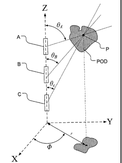
FIG. 2 illustrates the location of a higher density pod in a spherical
coordinate
system centered on detector B as detected by a substantially vertical three
detector
7
TRILJMF Ref. TRI-DISC-2004-10
CA 02603829 2007-08-15
WO 2007/084149 PCT/US2006/005578
arrangement in which CRM flux arriving at detector B and passing through a
region P
in the POD will be detected at a small range of angles centered at 0B and 4)
while the
CRM flux passing through region P and arriving at detectors A and C will be
detected
at different small ranges of angles eA and Bc respectively and at essentially
the same
angle 4);
FIG. 3 illustrates the location of a higher density pod in a spherical
coordinate
using multiple vertical detector arrangements in which CRM flux arriving at a
first
group of detectors A, B and C and passing through a region P in the POD will
be
detected at a small range of angles centered at OA, OB and Oc and 4) while the
CRM
flux passing through region P and arriving at a second group of detectors A',
B' and
C' will be detected at a small range of angles centered at BA', 6B' and 0 c'
and 4 ';
FIG. 4A illustrates the location of a higher density pod using multiple
horizontal detector arrangements in which CRM flux arriving at a first group
of
detectors A, B and C and passing through a region P in the POD will be
detected at a
first small range of angles while the CRM flux passing through region P and
arriving
at a second group of detectors A', B' and C' will be detected at another small
range of
angles; and
FIG. 4B illustrates some of the non-ideal conditions that should be taken into
account to improve the precision with which the higher density pod can be
located
using multiple detector arrangements including variations in the placement of
the
detectors relative to the POD, variations in the surface of the region under
analysis
and/or known or suspected strata or other geological formations that would
tend to
affect the CRM flux arriving at the detectors.
8
TRIUMF Ref. TRI-DISC-2004-10
CA 02603829 2007-08-15
WO 2007/084149 PCT/US2006/005578
[0017] These drawings have been provided to assist in the understanding of
the example embodiments of the invention as described in more detail below and
should not be construed as unduly limiting the invention. In particular, the
relative
spacing, positioning, sizing and dimensions of the various elements
illustrated in the
drawings are not drawn to scale and may have been exaggerated, reduced or
otherwise modified for the purpose of improved clarity.
[0018] Those of ordinary skill in the art will also appreciate that a range of
alternative configurations have been omitted simply to improve the clarity and
reduce the number of drawings. Those of ordinary skill will appreciate that
certain
of the various process steps illustrated or described with respect to the
example
embodiments may be selectively and independently combined to create other
methods useful for manufacturing semiconductor devices without departing from
the scope and spirit of this disclosure.
DETAILED DESCRIPTION OF EXAMPLE EMBODIMENTS
[0019] Example embodiments of the invention include a system for and a
method of using CRM for constructing and imaging a three-dimensional density
distribution of material within the earth. This technique may be used for
exploration
and location of higher (or lower) density mineral deposits or structures below
the
earth's (or ocean floor) surface. This technique may be utilized at depths of
up to
several kilometers for detecting and locating deposits or structures having
either
higher or lower density when compared to surrounding material.
9
TRIUMF Ref. TRI-DISC-2004-10
CA 02603829 2007-08-15
WO 2007/084149 PCT/US2006/005578
[0020] FIGS. 1 and 2 generally illustrate the concept in which one or more
substantially vertical holes 100 are drilled into the earth and at least one
CRM
detector, and preferably a series of CRM detectors, are inserted in the
hole(s) for
detecting CRM flux along a range of trajectories 102, 102'. Once the location
and/or
orientation of the detectors is determined or established, the direction of
travel (angles
9 and 0 in spherical coordinates), and optionally the approximate energy, of
each
detected muon can be collected and analyzed in order to construct an image of
the
material through which the muons have passed before reaching the detector(s).
[0021] In an example embodiment, the CRM detectors may be surrounded,
encompassed or otherwise shielded with some relatively high density material
to
reduce the detectors' sensitivity to "soft" or low energy particles, such as
electrons
resulting from muon breinsstrahlung. The data acquired by the tracking
detectors
consists of the 3-dimensional position of entry of the track in the detector
and the two
angles of incidence, 9 and 0, necessary to determine the detected particles'
trajectories. The rate of energy loss in the detector material may also be
measured for
particle identification. In addition, the presence of an induced magnetic
field near the
detectors could be used to obtain a measure of the CRM momentum.
[0022] After a suitable observation period, the data set for each detector
position, characterized by n(z, 0, gyp) , the intensity (or number of events)
observed at a
depth z and angles 9 and 0 may be analyzed to indicate the relative (or
locally
differentiated) and absolute flux distribution of CRM along the trajectories
through
the earth which intersected the detector or detectors.
TRIUMF Ref. TRI-DISC-2004-10
CA 02603829 2007-08-15
WO 2007/084149 PCT/US2006/005578
[00231 After correction for known topological and geographical features of
the study region are made, those regions having a significantly higher (or
lower)
density compared to nearby regions, e.g., the "POD" illustrated in FIGS. 1 and
2, will
result in a deficit (or surplus, respectively) of counts being detected at the
same
angle 0 for each detector position and will exhibit variations across the
different
angles 8 corresponding to the various detectors. The detected variations will
depend
on the relative positioning of the detectors and the POD depending on the
depth
compared to those trajectories which to not intersect the POD and reflect a
baseline
CRM flux from which the CRM flux though the POD deviates.
[00241 FIG. 1 illustrates an example embodiment of a detector system
according to the invention in which cosmic ray muons (CRM) impinging on the
surface of the earth penetrate to various depths depending on their energy and
the
amount of material encountered along their paths. The surviving CRM are may
then
be detected by one of a substantially vertically arranged group of detectors
A, B and C
provided in a borehole 100. The variations in both the distance traveled and
the
material through which the CRMs have traveled to reach the detector result in
corresponding variations in the CRM flux observed by detectors A, B and C
corresponding to different trajectories 102, 102'.
[00251 FIG. 2 illustrates the location of a high density pod in a spherical
coordinate system centered on detector B using a substantially vertical
detector
arrangement in which CRM flux arriving at detector B and passing through a
region P
in the POD will be detected at a small range of angles centered at 9B and 4)
while the
CRM flux passing through region P and arriving at detectors A and C will be
detected
11
TRIUMF Ref. TRI-DISC-2004-10
CA 02603829 2007-08-15
WO 2007/084149 PCT/US2006/005578
at a small range of angles 0A and 0c respectively. By comparing the CRM flux
detected along various trajectories, an image or plot of the relative
densities in the
regions traversed by the detected CRMs can be produced.
[0026] For example, as illustrated in FIG. 2, by comparing the data collected
by the various detectors and correlating the relative increases and decreases
in the
CRM flux an angular width, 00, and relative degree of the variation in the CRM
flux
can be used to determine the density and size of the POD and its distance (r)
from a
vertical (z) axis defined by the array of detectors. This data can also be
used to
generate a 2-D projection of the position of POD onto an X-Y plane as shown.
Although, as illustrated in FIG. 2, a plurality of detectors is utilized, as
will be
appreciated, corresponding data could also be collected by repositioning one
or a
small number of detectors and combining the CRM flux data collected from the
sequence of positions.
[0027] Similarly, as illustrated in FIG. 3, a plurality of detectors may be
arrayed in a plurality of boreholes, either simultaneously or sequentially,
for
collecting CRM data from a greater number of trajectories. As suggested by
FIG. 3, a
secondary group of detectors A', B' and C' would detect CRMs passing through
point
P of the POD at angles 0A', OB' and 0c', respectively and would reflect a
different
angle V and could locate the point P in a secondary X'-Y' coordinate space
oriented
about axis Z'. The data from the secondary detectors could then be combined
and/or
correlated with the data from the primary detectors to improve the accuracy
with
which the location, dimensions and/or content of the POD are determined.
12
TRIUMF Ref. TRI-DISC-2004-10
CA 02603829 2007-08-15
WO 2007/084149 PCT/US2006/005578
[0028] An example of the use of this technique may be explained by
considering a localized high density deposit, POD, at some depth L beneath the
earth's surface (assuming, for convenience, a flat surface topography and
relatively
uniform bulk geological strata), as illustrated in FIG. 1. CRM having
trajectories that
will cause them to pass through the POD before reaching one of the detectors
will, on
average, have traversed more material to reach the detectors, thereby
increasing the
likelihood that such CRM will not reach the detector. Accordingly, the CRM
flux for
such trajectories will be reduced or suppressed relative to those trajectories
that permit
the associated CRM to avoid traversing the higher density POD before reaching
a
detector.
[0029] As will be appreciated, conversely a POD having a reduced relative
density or comprising a void, such as a cavern, will tend to produce a
corresponding
increase in the CRM flux along those trajectories that transverse the lower
density
POD when compared with trajectories that allow the associated CRM to avoid
passing
through the POD. By measuring the CRM distribution including the incidence
angle
and, optionally, the energy, at two or more depths, variations in the CRM flux
may be
correlated to construct an image of the variable density region.
[0030] With sufficient exposure, a complete density distribution of the region
of the earth near the detectors would be obtained using techniques analogous
to those
employed in CT tomography as described in, for example, Klingenbeck-Regn.
Multiple holes with multiple detectors and/or reconfigurable or repositionable
detectors will increase detector coverage and/or data collection and can,
therefore, be
13
TRIUMF Ref. TRI-DISC-2004-10
CA 02603829 2012-02-23
used to enhance the statistical precision with which density images may be
obtained
or the precision with which localized variations in density may be defined.
[0031] An example embodiment of a system useful for geologic tomography
utilizing the example method described above may include a 10 cm diameter hole
drilled approximately 1 km into the earth. A series of 7-8 cm diameter time
projection chambers (TPC), as described by, for example, C. Hargrove et al.,
NIM
219 (1984) 461, having a length of about 1 in surrounded by 1 cm thick plastic
scintillation counters are positioned within in the drill hole at various
known depths.
[0032] As will be appreciated, a wide range of detectors may be successfully
employed in a system arranged for practicing the methods according to the
invention.
However, practical limitations imposed by the access to the desired detector
position(s) will tend to reduce the number or type of detectors that may be
considered
more suitable for a particular application. For example, although larger
"sheet"
detectors have been used for surface measurements, such detectors are
completely
unsuitable for positioning within a standard borehole. With respect to
detectors
intended for positioning within boreholes, however, shielding, additional
instrumentation, for example, accelerometers and/or magnetometers, and/or
positioning or aiming mechanisms may be incorporated for improving the quality
of
the collected data. To the extent that the orientation and/or configuration of
the
detectors within one or more detector arrays may be modified with the
detectors in
position, the modifications may be synchronized to allow "focusing" of the
array to
improve the data collection with respect to regions of particular interest.
14
CA 02603829 2007-08-15
WO 2007/084149 PCT/US2006/005578
[00331 Once positioned and activated, each TPC, triggered by the scintillation
counters (for example, in time coincidence on opposite sides of the TPC)
samples the
trajectory of traversing CRM using the ionization trail produced in the gas of
the
detector. As noted above, each detector or group of detectors may be provided
or
associated with one or more precision accelerometers, or other suitable
inertial
measurement unit ("IMU") or device, capable of determining the position and
orientation of the detector or detector array within a known margin of error.
[00341 As will be appreciated, the precision with which the depth and
orientation of the detectors may be determined will improve the accuracy of
the
density images or maps generated from the detector data. For example, drill
holes or
bore holes are rarely, if ever, completely vertical. The data from the
accelerometers
and/or other IMUs may be used in combination with GPS devices and/or
conventional
cartographic tools for improving the accuracy of the positioning information
for each
of the detectors and thereby compensate for drill hole deviations or
"wandering"
and/or deliberately non-vertical holes formed by "slant" drilling. Through the
use of
such techniques the positioning of the detector may determined with a
precision on
the order of 10 mrad or better. Conventional accelerometers and other IMUs are
readily available from a number of commercial vendors and are easily
accessible by
those skilled in the art. The company MEMSIC, for example, is a provider of
accelerometers and sensors, particularly CMOS-based MEMS
accelerometers/sensors,
and provides those skilled in the art with various tools for identifying one
or more
devices that would be suitable for a particular application.
TRIUMF Ref. TRI-DISC-2004-10
CA 02603829 2012-02-23
[0035] An alternate example embodiment shown in FIG. 4A of a system
useful for geologic tomography utilizing the example method described above
may
include one or more large area (e.g., 2 in x 2 m) TPC detector systems with
plastic
scintillator trigger detectors placed horizontally in a mine or other
underground
cavity. Time projection chambers (TPC), as described by, for example, C.
Hargrove
et al., NIM 219 (1984) 461, having a length of about 1 in surrounded by 1 cm
thick
plastic scintillation counters are placed at various depths or at various
horizontal
locations. Each TPC, triggered by the scintillation counters (perhaps, in time
coincidence on opposite sides of the TPC) samples the trajectory of the
detected muon
using the ionization trail produced in the gas of the detector by the muon as
described
above to determine the direction of the detected muon. As will be appreciated,
data
from horizontal detector arrays and vertical detector arrays may be combined
to
improve the accuracy of the scan as permitted by the site limitations and
thereby
improve the system flexibility and adaptability.
[0036] Illustrated in FIG. 4B is an example embodiment in which additional
variables are indicated including an irregular surface topography, non-uniform
strata
and offset detector arrays. Based on the data available, each of these
variables can be
taken into account during the analysis of the CRM flux data from the various
detectors and detector arrays. For example, topographic profiles, accurate
detector
positioning and orientation data and strata data provided by core sampling
and/or
active seismic tomography in which generated shock waves are applied to a
survey
site region, reflected off the underlying rock strata at variable velocities
and detected
by an array of geophones arrayed across the surface of the survey site. As
16
CA 02603829 2012-02-23
will be appreciated, some initial substrate composition data can be obtained
during the
drilling of the boreholes utilized for the vertical detector installations
and/or may have
been collected during the excavations by which openings or chambers in which
larger,
e.g., > 1 m2, detectors can be deployed, for example, a horizontal
configuration, as
suggested in FIGS. 4 A and 4B, in a mine.
[0037] In the TPCs, ten or more 3-dimensional track coordinates may be
recorded with precision of 300 pm (or better) for each coordinate. The angular
resolution thus obtained for each muon track will typically be better than 10
mrad.
Thus, for a structure located 100 in from the detector, the position
sensitivity for
density variations would be of order 1 m. As will be appreciated by those
skilled in
the art, the actual precision with which the system can define or demarcate
the
boundaries of localized density variations will depend on various factors
including,
for example, the exposure time and uniformity of the bulk material in the
region being
examined, the accuracy with which the location and orientation of the
detectors can be
determined and the presence or effectiveness of detector shielding to suppress
detection of "soft" particles.
[0038] The CRM energy and angle distributions of CRM at the surface of the
earth and at depths up to many kilometers are relatively well known and have
previously been measured, as described by Nagamine and Tanaka, as well as in
R.K.
Adair and H. Kasha, Muon Physics, eds. V.W. Hughes and C.S. Wu, vol. 1
(Academic Press, 1976) p. 323, and by the Particle Data Group, Phys. Lett. B
592
(2004) 1. Drilling holes of the required diameter and depth is well within the
17
CA 02603829 2007-08-15
WO 2007/084149 PCT/US2006/005578
conventional drilling practices and techniques currently employed in
geological
exploration.
[0039] TPCs triggered by scintillators are tracking devices and are known to
have the properties described above. The TPCs triggered by scintillation
counters,
however, represent just one example of a suitable compact position sensitive
tracking
detector system commonly employed in particle and nuclear physics experiments.
Those of ordinary skill in the art will appreciate, therefore, that the TPCs
described
above may be replaced by or used in conjunction with other types of radiation
detectors of suitable size and sensitivity that could be used in the present
application.
[0040] The present invention, therefore, encompassed both the configuration
of equipment and the method of utilizing such equipment to examine or evaluate
the
tomographic configuration of the earth for geological exploration using cosmic
ray
muons impinging at all possible angles on deeply positioned detectors. In this
technique, CRM of all angles impinging on the detectors would be used to
survey the
nearby region of the earth using differential intensity variations n(z, , cp)
and,
depending on the number and location of the detectors, maybe used to develop a
subterranean density map. This apparatus and technique may be useful, for
example,
in identifying and imaging mineral and/or petroleum rich regions within a
larger
region. Similarly, this apparatus and technique may be useful for identifying
and
imaging subterranean voids such as natural caverns or abandoned mines.
18
TRIUMF Ref. TRI-DISC-2004-10