Note: Descriptions are shown in the official language in which they were submitted.
CA 02612259 2007-12-13
WO 2007/008559 PCT/US2006/026286
SYSTEM AND METHOD FOR CSEM EXPLORATION IN POLAR REGIONS
Technical Field
This invention relates to the general subject of geophysical exploration for
hydrocarbons and, in particular, to methods for collecting and analyzing
controlled
source electromagnetic ("CSEM", hereinafter) earth survey data, with
particular
reference to polar regions of the earth.
Background of the Invention
Measurements of subsurface electrical resistivity have long been used to
differentiate roclc layers that contain hydrocarbons froiri other rock units
that do not
contain hydrocarbons. For example, resistivity well logs have been routinely
used for
many years to identify producing intervals within existing well bores.
However, more
recently, it has been found feasible to use surface surveys, which do not
require that a
well be drilled, in order to detect subsurface hydrocarbon deposits. That is,
information collected on the surface is -used to determine the subsurface
resistivity
distribution in the subsurface - in a non-invasive fashion - beneath a line of
receivers,
the resistivity being indicative of the presence or absence of such deposits.
The ability
to detect hydrocarbon deposits from the earth's surface, through
electromagnetic
methods, is of most interest for purposes of the instant disclosure.
Generally speaking, the subsurface has relatively few large contrast
resistivity
boundaries. However, rocks units that contain hydrocarbons tend to show a
large
resistivity contrast in comparison with the rocks that enclose them and, as a
consequence, resistivity-based methods have long been viewed as potential
direct
hydrocarbon indicators. For example, the resistivity of a hydrocarbon bearing
formation could be on the order of a few tens of Ohm-m or higher, as compared
with
the resistivity of the over- and under-lying water-saturated sediments, which
have
resistivity on the order of 2 Ohm-m or less. Thus, when hydrocarbons are
present in
the subsurface, resistivity-based methods can potentially be used to detect
them when
other geophysical methods would not. As a consequence, there is currently a
great
deal of interest in using electromagnetic ("EM") methods to locate new sources
of
trapped hydrocarbons, monitor the hydrocarbon distribution within an existing
reservoir (e.g., reservoir monitoring over time), etc.
CA 02612259 2007-12-13
WO 2007/008559 PCT/US2006/026286
Although there are a number of EM survey variants, of particular interest for
purposes of the instant disclosure are surveys that utilize a "controlled
source" (i.e.,
controlled source electro-magnetic measurements, or "CSEM", hereinafter), as
opposed to those that utilize a natural source ("magnetotelluric" surveys).
CSEM
surveys are conducted in both marine and onshore environments. In a marine
environment, the survey is typically conducted with a boat pulling a
horizontally
disposed electric dipole source, near the sea bottom, above a set of sea
bottom
receivers. The source is powered by an electrical generator that is situated
on the boat.
The source will usually be programmed to create a low frequency (or other
programmed variation) electromagnetic signal by varying the voltage that is
supplied
to the electric dipole.
In the case of land surveys, a series of source and receiver electrodes are
laid
out on the surface of the earth. In some instances, the electrodes are mounted
on
metal spikes so that they can be pushed into the earth, thereby improving
their
coupling to the ground. Those of ordinary skill in the art will recognize that
local
conditions of soil conductivity are crucially important to the quality of this
coupling.
The CSEM techniques described below are understood to yield low-resolution,
but direct indications, of the presence of hydrocarbons. By contrast, seismic
exploration techniques yield higher-resolution images of the subsurface
layering, but
only indirect indications of the presence of hydrocarbons. A combination of
these two
types of surveys can be a powerful method of exploration.
Although CSEM surveys come in many forms, such surveys may utilize, as a
signal source, a time-varying electrical current that is introduced into the
subsurface
through electrodes or lines of contact at the surface, making a grounded-
dipole source.
The electrodes might either, be placed in direct contact with the surface of
the earth
(e.g., in a land survey) or towed behind a boat through the water (e.g., in a
marine
survey). Such grounded dipoles produce propagating electromagnetic fields
which are
sensitive to resistive anomalies in the subsurface, and hence may be
associated with
hydrocarbons. Alternatively, the sources might be current loops, which
inductively
produce propagating electromagnetic fields; however these are sensitive to
conductive
anomalies, rather than to resistive anomalies, and hence are more useful in
the context
of mineral exploration and less so in the petroleum context.
2
CA 02612259 2007-12-13
WO 2007/008559 PCT/US2006/026286
In a conventional CSEM survey, receivers are positioned on the earth's surface
- to include receivers positioned on the ocean bottom - which are designed to
measure the electric and/or magnetic fields that are induced by the source.
These
measurements are used to estimate the effective or apparent resistivity of the
subsurface beneath the receivers, according to methods well lcnown to those of
ordinary skill in the art. Note that, depending on the signal source and
survey design,
the receivers might be situated at distances from zero to 20 kilometers away
from the
source. In general, longer offsets are required in order to investigate deeper
into the
earth.
As the source is activated in the vicinity of the receivers, electromagnetic
energy propagates from source to receiver, via a variety of paths, and the
variations in
the amplitude and phase of these fields are detected and recorded by each of
the
receivers. Various processing algorithms are then used to estimate the
resistivity
structure of the subsurface beneath the survey.
In some variations, alternating currents are employed as the signal source,
with
the polarity of such current being reversed at a selected frequency. Any such
surveying, with continuous source operating at one or a few selected
frequencies
(including harmonics) may be called frequency-domain controlled source
electromagnetic surveying (f-CSEM). f-CSEM techniques are described, for
example,
in Sinha, M.C. Patel, P.D., Unsworth, M.J., Owen, T.R.E., and MacCormack,
M.G.R.,
1990, An active source electromagnetic sounding systena for marine use, Marine
Geophysical Research, 12, 29-68, the disclosure of which is incorporated by
reference
herein as if fully set out at this point.
In the marine context, the most common CSEM acquisition methods all use
frequency-domain techniques and, more particularly, they use a continuous
source
signature that operates at one or a few discrete frequencies; Srnka (US Pat.
6,603,313,
the disclosure of which is incorporated herein by reference) is a good
example, citing
several other recent patents and publications sharing this same class of
techniques.
Another controlled source technique for electromagnetic surveying may be
called transient (or time-domain) controlled source electromagnetic surveying,
referred to as "t-CSEM" hereinafter. In t-CSEM, an electrode is used to create
an
electric current in the same general manner as was discussed previously in
connection
with f-CSEM, except that the source is impulsive (or of short duration),
rather than
3
CA 02612259 2007-12-13
WO 2007/008559 PCT/US2006/026286
continuous. For example, the electrode may be charged using a DC (i.e.,
"direct
current") source, which, after some time, is then shut off, causing an abrupt
terinination of current. Data is then collected from the receivers during the
extended
time interval that the current is inactive. Of course, such data display a
general decay
in the measured voltages as time progresses subsequent to the source shut-off.
Note
that this is in contrast to f-CSEM methods which collect data from the
receivers while
the source is active. The time variation of the t-CSEM voltages that are
observed after
the termination of the source current is used to infer the resistivity
structure of the
subsurface. T-CSEM techniques are described, for example, in Strack, K.-M.,
1992,
Exploration with deep transient electr ornagnetics, Elsevier, 373 pp.
(reprinted 1999),
the disclosure of which is incorporated herein by reference as if fully set
out at this
point. For the most part, t-CSEM techniques have traditionally been used in
connection with land surveys (see Everett, M.E., Benavides, A., and Pierce,
C.J.,
2005, An experimental study of the time-domain electromagnetic response of a
buried
conductive plate, Geophysics 70(1), G1, for an application in the context of
exploration for unexploded ordinance).
On land, CSEM acquisition techniques are generally well established (cf, e.g.,
the textbook by Strack, K. M., Exploration with Deep Transient
Electronaagnetics,
Elsevier, 1999). However, land application of CSEM in the hydrocarbon context
has
been hampered heretofore by difficulties in survey execution, caused by
variable
coupling of the sources and receivers to the ground. In the most common
application,
both sources and receivers are attached to the ground via electrodes, which
penetrate
the ground as far as is practicable. However, the properties of the ground in
the
vicinity of the electrodes (e.g., variable soil conditions, water saturation,
etc.),
especially the source electrodes, affects the coupling to the deeper
subsurface, so that,
if the coupling is not good, the resulting data is weak and variable, and the
subsurface
signal is compromised. In particular, the strong and variable mismatch in
electrical
impedance (between the instruments, the near-by ground, and the deep
subsurface)
contributes strongly to these acquisition difficulties. (By contrast, in
marine CSEM,
there is no coupling problem, since sources and receivers are intimately and
uniformly
coupled to the ocean bottom via seawater.)
Because of this ground-coupling problem, the success of land CSEM
techniques has been variable, and they have not historically been proven to be
broadly
4
CA 02612259 2007-12-13
WO 2007/008559 PCT/US2006/026286
useful for hydrocarbon exploration. However, recently attempts to provide
commercial services have been launched; these services have been restricted to
the
conventional oil basins of temperate and tropical latitudes.
Exploration for hydrocarbons in the Polar regions of the earth is hindered by
a
myriad of practical difficulties associated with the cold temperatures: men
and
equipment simply do not function well in such environments. In particular,
offshore
the floating paclc ice malces conventional seismic exploration infeasible, and
onshore
the surface conditions severely discourage the application of proven methods
of
exploration. Under these conditions, practitioners have not even attempted to
apply
CSEM exploration methods, which have proven to be unreliable in less harsh
conditions, to these more difficult polar environments.
Heretofore, as is well known in the geophysical prospecting and interpretation
arts, there has been a need for a method of using CSEM techniques to obtain a
resistivity irnage of the subsurface that does not suffer from the limitations
of the prior
art. Accordingly, it should now be recognized, as was recognized by the
present
inventors, that there exists, and has existed for some time, a very real need
for a
method of geophysical prospecting that would address and solve the above-
described
problems.
Before proceeding to a description of the present invention, however, it
should
be noted and remembered that the description of the invention which follows,
together
with the accompanying drawings, should not be construed as limiting the
invention to
the examples (or preferred embodiments) shown and described. This is so
because
those skilled in the art to which the invention pertains will be able to
devise other
forms of this invention within the ambit of the appended claims.
Summary of the Invention
According to a preferred aspect of the instant invention, there is provided a
system and method of collecting CSEM data (and especially t-CSEM data), which
pennits effective exploration, appraisal, development, and surveillance of
liydrocarbon reservoirs in polar regions by providing improved ground coupling
between the electrodes, the surficial ice, the sub-ice water, and hence, to
the earth
itself. As a consequence, a higher quality transmitted and received signal is
obtained,
5
CA 02612259 2007-12-13
WO 2007/008559 PCT/US2006/026286
and through the use of the methods taught herein, CSEM becomes feasible for
use in
hydrocarbon detection in such regions.
According to a first preferred einbodiment, the instant invention utilizes
time-
domain Controlled-Source Electromagnetic surveys ("t-CSEM") that are taken on
ice
or on land in regions covered by ice or snow. Through the use of this
technology,
such EM surveying may be carried out, for example, on the frozen surface of
the
Arctic Ocean, or the frozen forests of Siberia or the polar archipelago of
Canada,
opening these areas (which are notoriously difficult in which to acquire good
survey
data of any type) to effective exploration and exploitation of their
hydrocarbon
resources.
By way of summary, the present inventors have discovered that, where the
surface of the ground is saturated and frozen (such as in the case of a survey
conducted on sea ice, or frozen tundra), the instruments (sources and
receivers) may
be coupled more faithfully to the subsurface by drilling or melting holes in
the ice (or
frozen tundra) by any of a number of methods, and inserting electrodes into
the
resulting holes. If on floating ice, the holes should preferably be drilled
through the
ice into the water below. If on land, the holes may (or~may not) be lined with
material
to retard the loss of water therefrom. Upon filling the holes with water
(frozen or not,
freshwater or salt water, etc.), and connecting the immersed electrodes to the
recording instruments, the resulting coupling is virtually as good as it would
be in the
case of marine t-CSEM survey, and the land data collected via this approach
will
likely be of equivalent quality. Ice is generally a poor conductor, but it is
of uniform
quality (from point to point in the survey), and so its lack of conductivity
may be
somewhat compensated for, in survey design (e.g., in source strength, source
electrode-array design, source electrode-material, etc.).
After the source electrodes are in position within their holes, electrical
energy
is injected into the ice or other surface via those electrodes. The signal
will then be
received (via surface and subsurface propagation paths) at receiver electrodes
similarly implanted at a range of distances from the source. Alternatively,
the
receivers could be of different design, e.g., current loops, measuring
magnetic fields
directly, and electric fields by inductance.
[0001] Note that this approach makes it possible for the first time to collect
high
quality EM data in a marine setting by using modified land techniques. That
is, one
6
CA 02612259 2007-12-13
WO 2007/008559 PCT/US2006/026286
aspect of the instant invention involves conducting a CSEM survey on the paclc
ice
floating on water (fresh- or salt-water). Obviously, if the weather were
wariner, and
the ice were melted, a conventional or unconventional marine survey could be
conducted (e.g., as is generally indicated in Figure 5). However, in polar
regions the
season of open water is short or absent, so that these marine techniques have
limited
applicability. However, when the body of water (or at least a portion of it)
freezes
over, a land-style survey may be conducted instead on the resulting ice layer.
In the
case of marine surface ice, the electrode holes may easily penetrate the
floating ice,
reaching the unfrozen seawater below (which has excellent conductivity), and
avoiding altogether those problems caused by the poor conductivity of ice. In
this
marine case, the data are analyzed by means described elsewhere, perhaps
taking
special steps to account for reflection from the seafloor.
In another variation, there is provided a method of EM exploration in polar
regions that may be covered by tundra, or by swamps, or by wide shallow rivers
which
are ecologically fragile, particularly during warmer seasons. Those of
ordinary skill in
the art will recognize that the only practical time to enter such areas with
men and
equipment is during the colder seasons, vvhen the surface is stabilized by ice
and
snow-cover. During that season seismic exploration is feasible, but
logistically
difficult, because the cold weather causes mechanical devices (e.g. vibrators)
to fail
more often than in yvarmer weather. Further, obtaining high quality coupling
of
seismic geophones to the ground during this time is problematic. Also, seismic
sampling requirements are more stringent than are EM sampling requirements
(since
the seismic wavelengths are shorter than the EM wavelengths, in typical
practice), so
that many more source-locations and receiver-locations are required for
seismic
surveying than for CSEM surveying. According to the instant invention there is
provided a CSEM surveying method substantially as described above, but wherein
the
ground coupling is improved by digging or drilling holes into the tundra or
ice into
which the electrodes are thereafter placed. Note that through the use of the
present
invention, CSEM in such environments can serve to identify areas that are
likely to
contain hydrocarbons in the subsurface, making it possible to high-grade those
particular areas for subsequent seismic surveys that are more suitable for
obtaining
high-resolution seismic images of those reservoirs.
7
CA 02612259 2007-12-13
WO 2007/008559 PCT/US2006/026286
In another variation, in a survey conducted on ice or snow, magnetic energy is
injected into the ice, via current loops deployed over the ice, and received
(via surface
and subsurface propagation paths) at current loops similarly deployed, at a
range of
distances from the sources. This sort of survey is particularly useful at
finding
conductive anomalies, rather than resistive anomalies (hydrocarbons).
Nevertheless,
the present invention can be utilized to conduct such a conventional land-
based
magnetic survey on top of floating ice during cold weather. Compared to
conventional
marine CSEM surveying (with sources and receivers near the sea-floor), a
marine
survey conducted as described above requires that the EM energy signal from
the
subsurface propagates additionally through the water layer, twice (down and
up). This
means that the current invention will be more useful in shallow waters than in
deep
waters, although with sufficiently powerful sources and sufficiently sensitive
receivers, the depths can be extended. Modeling shows that sea-water of 100m
depth
causes no serious problems.
In summary, the present inventors have discovered that a critical feature of
the
marine environment, which makes conventional CSEM practical in that setting,
is the
intimate and uniform coupling of sources and receivers to the medium
(seawater).
Those skilled in the art of marine CSEM will realize that deep water (relative
to target
depth) is also important to the practicality of f-CSEM, but that this
restriction does not
apply to t-CSEM. As is disclosed herein, the present inventors have realized
that this
coupling-principle can also be realized in polar environments, because of the
ubiquity
in such environments of ice and snow. This is a key aspect of the present
invention,
i.e., the realization that according to the techniques taught herein ice
provides for good
coupling in polar environments in the same fashion as water provides same in
marine
environments, thereby making it possible to collect high quality CSEM data. In
particular, the techniques taught herein enable the collection of high-
quality, CSEM
data, suitable for exploration for the deep resistivity anomalies
characteristic of
hydrocarbon reservoirs.
Although others have conducted land EM surveys in regions with permafrost
(e.g., in Prudhoe Bay to examine the depth of the permafrost at depths up to
300 m,
and in Siberia, using offsets up to 2 km, to look for Induced Polarization
effects, at
depths to 2 km, associated with hydrocarbon reservoirs situated deeper), it is
a
8
CA 02612259 2007-12-13
WO 2007/008559 PCT/US2006/026286
testimony to the novelty of the present invention that these practitioners,
operating in
such a closely related arena, failed to conceive of this invention.
Finally, it should be noted and remembered that when the terins "artic",
"polar
regions", etc., are used herein those terms should be understood in their
broadest sense
to indicate that the preferred operating environment for the instant invention
includes
land or marine regions covered with ice and snow permanently or temporarily,
as well
as regions with frozen surface soil (e.g., permafrost), and thus would also
include
mountainous regions, as well as regions of high latitude. With that said, it
is also
clear that, since ice is resistive, the techniques disclosed herein would be
best applied
where the sections of ice or fresh water are relatively thin, i.e., the ideal
environment
for application of the instant invention is one of floating ice above salt
water (although
as noted above, other "polar" environments are also feasible).
The foregoing has outlined in broad tenns the more important features of the
invention disclosed herein so that the detailed description that follows may
be more
clearly understood, and so that the contribution of the instant inventor to
the art may
be better appreciated. The instant invention is not to be limited in its
application to
the details of the construction and to the arrangements of the components set
forth in
the following description or illustrated in the drawings. Rather, the
invention is
capable of other embodiments and of being practiced and carried out in various
other
ways not specifically enumerated herein. Finally, it should be understood that
the
phraseology and terminology employed herein are for the purpose of description
and
should not be regarded as limiting, unless the specification specifically so
limits the
invention.
Brief Description of the Drawings
Other objects and advantages of the invention will, become apparent upon
reading the following detailed description and upon reference to the drawings
in
which:
Figure 1 illustrates the general environment of the instant invention
Figure 2 illustrates a conventional EM survey as it would be conducted on ice
or frozen ground.
Figure 3 contains an illustration of an EM survey conducted on ice or frozen
ground according to the instant invention.
9
CA 02612259 2007-12-13
WO 2007/008559 PCT/US2006/026286
Figure 4 illustrates a preferred t-CSEM operating logic.
Figure 5 contains a schematic illustration of a prior art approach to
conducting
a marine EM survey.
DETAILED DESCRIPTION
While this invention is susceptible of being embodied in many different forms,
there is shown in the drawings, and will herein be described, some specific
embodiments of the instant invention. It should be understood, however, that
the
present disclosure is to be considered an exemplification of the principles of
the
invention and is not intended to limit the invention to the specific
embodiments or
algorithms so described. In particular, although the exemplification is
generally given
in terms of t-CSEM, those skilled in the art will recognize that, with good
coupling of
electrodes to the ground, f-CSEM techniques might also be used.
GENERAL ENVIRONMENT OF THE INVENTION
Figure 1 illustrates the general environment in which the instant invention
would typically be used. As a first step, an EM survey will be designed (step
110),
wherein such design would typically include specification of various survey
parameters that are designed to define the target and improve the quality of
the
resulting survey. Among the many paralneters that might be considered in
formulating the survey design are:
= the surface area to be covered by the survey;
= the time of year that the survey is to be taken, including temperature and
ice-
cover considerations, as well as natural electromagnetic noise conditions;
= whether the survey will be taken on land (to include ice), offshore, or a
combination of the two;
= the depth of the target;
= the 3-D structure of the target (including its 2-D or 3-D dip, if any);
= whether the design will utilize an "end on" configuration (e.g., as is
generally
indicated in Figure 2 wherein all of the active receivers are on the same side
of
the source) or a "split spread" configuration (i.e., as is generally
illustrated in
CA 02612259 2007-12-13
WO 2007/008559 PCT/US2006/026286
Figure 5 wherein active receivers are placed both ahead of and behind of the
source);
= the maximum offset (i.e., the distance from the source 210 to the most
distant
active receiver 220) and minimum offset (i.e., the distance from the source
210
to the closest active receiver 220);
= the receiver-to-receiver spacing;
= the source-point spacing (i.e., the shot-to-shot spacing, where "shot" is
used in
the sense of "source activation point");
= the relation between source-points and receiver-points (e.g., sources near
to
receivers, sources midway between receivers, etc.);
= the frequencies expected in the received data;
= the strength of the sources, and the sensitivity of the receivers, etc.
Of course, the selection of parameters such as the foregoing are design
choices
that are well within capability of one of ordinary skill in the art. Further,
those of
ordinary skill in the art will recognize that many of the previous parameters
are
interrelated (e.g., specification of the target depth determines in a general
way a
preferred maximum offset).
Next, equipment (including source and receiver electrodes, generators,
recording instruments, etc.) will be moved to and set up in the field and an
EM survey
conducted 120 that is preferably at least approximately in accordance with the
original
design. Of course, it is certainly possible that some on-site changes will
need to be
made to the survey as-designed. However, generally speaking the goal of the
field
crew is to replicate the paraineters of the original survey parameter
specifications as
closely as is possible.
As will be discussed in greater detail hereinafter, one aspect of the survey
process that reflects the contribution of the instant inventors involves the
way that the
source and/or receiver electrodes are coupled to the ice or ground. In brief,
in the
preferred arrangement each electrode - whether a receiver or a source - will
be placed
within a hole that has been prepared for that purpose. Preferably, after the
electrode is
placed therein the hole will be filled with a conductive liquid such as water
in advance
of data collection, thereby improving the coupling between the electrical
component
and the earth's surface. Electrodes made of special materials, e.g. lead, may
be used
to prevent corrosion (as is well known to those skilled in the art).
11
CA 02612259 2007-12-13
WO 2007/008559 PCT/US2006/026286
After preparing the source and receiver electrodes as described above, the
data
will preferably be collected conventionally depending on the sort of survey
that is
being taken. Preferably, the survey will be of the t-CSEM variety. However, it
is
certainly possible that other sorts of EM surveys might be conducted.
As is typical in EM surveys, the source will be activated and the voltage (or
an
equivalent quantity) will thereafter be measured at each of the receiver
electrodes.
The response of each receiver to the source will preferably be captured
digitally as a
function of time and stored on magnetic or other media for transportation to a
centralized computing facility wllere the data will be processed, interpreted,
and
integrated into other data taken over the same prospect. That being said, in
some
instances some amount of initial processing 130 will be applied to the data
while it is
in the field. For example, such in-field processing might be done in order to
verify the
quality of the data that are being collected. In other instances, the data
might be
processed to see whether or not the target subsurface rock units are being
imaged
adequately. In any case, the data will after field processing will usually at
least be
relatable to specific locations on the surface of the earth.
Although the data that are collected according to the instant invention may be
processed to some extent in the field (step 130), eventually it will typically
be
transferred to a processing center where more computing resources 150 and
algorithms 140 are available. In the processing center a variety of processes
140
might be applied to the data to make them ready for use by the explorationist.
At
some point the processed data traces will likely be stored, by way of example
only, on
hard disk, magnetic tape, magneto-optical disk, DVD disk, or other mass
storage
means.
Note that a general purpose computer 150 would typically include, in addition
to mainframes and workstations, computers that provide for parallel and
massively
parallel computations, wherein the computational load is distributed between
two or
more processors. As is also indicated in Figure 1, in some preferred
embodiments a
digitized zone of interest model 160 would be specified by the user and
provided as
input to the processing computer program. In the case of a 3-D geophysical
data, the
zone of interest 160 would typically include specifics as to the lateral
extent and
thickness (which might be variable and could be measured in time, depth,
frequency,
etc.) of a subsurface interval. The exact means by which such zones are
created,
12
CA 02612259 2007-12-13
WO 2007/008559 PCT/US2006/026286
picked, digitized, stored, and later read during program execution is
unimportant to
the instant invention and those skilled in the art will recognize that this
might be done
any number of ways.
The algorithms that are used to process the EM data might be conveyed into
the computer 150 by means of, for example, a floppy disk, a magnetic disk, a
magnetic tape, a magneto-optical disk, an optical disk, a CD-ROM, a DVD disk,
a
RAM card, flash RAM, a RAM card, a PROM chip, or loaded over a network.
After preprocessing, the data may be "imaged" (preferably by utilizing steps
such
as those described in U.S. Provisional Patent S.N. 60/654,378, cited
previously).
Alternatively or additionally, the data may "inverted" to produce optimal
values for a
subsurface model defined a priori, following any of a large number of
inversion
algorithms.
After the EM data has been subjected to the processes discussed herein, the
resulting
information would typically displayed either at a high-resolution color
computer
monitor 170 or in hard-copy form as a printed section or a map 180. The
geophysical
interpreter would then use the displayed images to assist him or her in
identifying
subsurface features conducive to the generation, migration, or accumulation of
hydrocarbons.
PREFERRED EMBODIlVIENTS
According to a first preferred embodiment, the instant invention is directed
toward the application of a novel variant of the standard technique of time-
domain
Controlled-Source Electromagnetic surveying ("t-CSEM") to the exploration,
appraisal, development and surveillance of hydrocarbon reservoirs. In more
particular, the instant invention is designed to provide improved source /
receiver
ground coupling in areas that have heretofore proven to be difficult data
acquisition
areas. According to one aspect of the instant invention, there is provided a
method of
improving ground coupling in an EM survey which involves placing each source
and/or receiver electrode in a hole that has been drilled (or melted in the
case of ice)
into the surface. Additionally and preferably, the hole will be at least
partially filed
with a conductive fluid such as water, thereby improving the coupling between
the
electrode and the surface in which it is embedded. According to another
preferred
embodiment there is provided a method for collecting EM data over a body of
water
13
CA 02612259 2007-12-13
WO 2007/008559 PCT/US2006/026286
that involves waiting until cold weather freezes the water and then taking the
survey
over ice, with the electrode holes drilled through the ice, into the
conductive water
below.
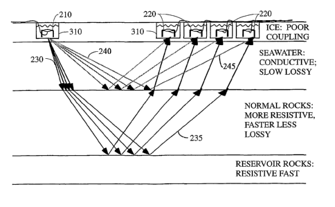
Turning first to Figure 2, wherein the prior art method of collecting EM data
over ice and in other difficult data acquisition areas is illustrated, in a
conventional
arrangement the source 210 and receiver 220 electrodes are placed into contact
with
the surface by driving metal stakes into ground or ice. As is generally
indicated in this
figure and as is well known to those of ordinary skill in the art, depending
on a
number of factors the electrical contact between the stakes and the surface
might be of
lower quality than would be desired. Factors such as the degree of
consolidation,
hardness, etc., of the surface of the earth (e.g., the ice in Figure 2), the
depth of
penetration of the surface by the stakes, the water content and its state
(e.g., liquid or
frozen), etc. all can have some bearing on the source 210 / 220 receiver
ground
coupling. Of course, poor coupling means that the energy that is transmitted
downward from the surface (down going energy 230 and 240) will likely be
attenuated
and/or corrupted as will be the signal that is subsequently sensed (up-going
energy
235 and 245) by the receivers 220.
Turning next to Figure 3, wherein a schematic illustration of a preferred
aspect
of the instant invention is presented, the present inventors have discovered
that, where
the surface of the ground is saturated and frozen (such as in the case of a
survey
conducted on sea ice, or frozen tundra), the instruments (sources and
receivers) may
be coupled more faithfully to the ground by drilling or melting holes in the
ice (or
frozen tundra) by any of a number of methods, and inserting electrodes into
the
resulting holes. As is generally indicated in Figure 3, rather than placing
the
electrodes 210 and 220 on the surface of the, for example, ice, instead a hole
310 will
be dug or melted therein. In the preferred arrangement, the hole will have a
depth of
about at least 2-3 feet, although a deeper hole would likely produce better
results (e.g.,
about ten feet deep). However, those of ordinary skill in the art will
recognize that
these measurements are only suggestions and the actual depth used in a
particular
circumstance might be substantially different depending on the ground type,
equipment available (e.g., if a drilling rig is available a much deeper hole
could be
quickly created), etc. Of course, if the survey is conducted over pack ice,
its thickness
might be only a few tens of feet thick (e.g., 10 to 20 feet thick) and in such
a
14
CA 02612259 2007-12-13
WO 2007/008559 PCT/US2006/026286
circumstance a drilling rig could punch a hole completely through the ice in
short
order. In such a circumstance, the source 210 and receiver 220 electrodes
could
actually be suspended underneath the surface ice if that were desired. In such
a
circumstance, it would be possible to create a vertically dispoed dipole
source
underneath the ice, in contrast to the horizontal dipoles of the sort utilized
in Figure 5.
Next, and as is generally indicated in Figure 3, the source 210 and receiver
220
electrodes will be placed in the holes 310 prepared for that purpose. After
the
electrodes are so positioned, a fluid such as water will be added to the hole.
Preferably sufficient fluid will be added as to cover at least the conductive
portion of
the electrode.
In some preferred embodiment, the water / fluid will be allowed to freeze
within the hole 310 if that is possible at the current temperature. That is
not required
but might be useful in some circumstances.
In the event that water is used, there are two obvious choices: fresh water
and
salt water. Generally speaking, salt water will generally be preferred for its
superior
electrical conduction properties (as compared with fresh water). However,
since salt
water is more corrosive than fresh water, the superior conductivity of salt
water must
be weighed against the possibility that the electrode (or other components)
would have
its useful life shortened.
Of course, one immediate consequence of filling the hole with fluid / water is
that the coupling between the electrode and the surrounding rock will be
greatly
enhanced. Further, if the hole 310 that contains the electrode is melted into
ice, by
allowing the water placed therein to freeze the electrode will be thoroughly
integrated
into the surrounding ice.
Note that the holes may (or may not) be lined with material to retard the loss
of
water therefrom. Such lining might be especially desirable when the survey is
conducted on land and, for example, where the near surface is relatively
unconsolidated (e.g., sandy loam, glacial till, sand, etc.). In such an
embodiment,
preferably the lining will be at least somewhat impermeable to the passage of
water
therethrough and somewhat conductive to foster emission of the signal from -
or
reception by - the electrode.
Upon filling the holes with water (frozen or not, freshwater or salt water,
etc.)
or other fluid, and connecting the immersed electrodes to the recording
instruments,
CA 02612259 2007-12-13
WO 2007/008559 PCT/US2006/026286
the resulting coupling should be virtually as good as it would be in the case
of a
marine t-CSEM survey.
After the electrodes are in position within their holes, electrical energy
will be
injected into them and, subsequently, into the subsurface. As is generally
indicated in
Figure 3, the returning signal will then be received (via subsurface
propagation paths)
at electrodes placed at a range of distances from the source. Of course, it is
anticipated that the data so acquired will be subsequently processed, talcing
into
account the reflection of the signal from the bottom of the body of water.
Preferably, the instant method will utilize EM data that have been taken
according to CSEM acquisition techniques (and especially t-CSEM and f-CSEM
data). That being said, those of ordinary skill in the art will recognize that
the other
methods of taking EM data could similarly benefit from the increased coupling
provided by the instant invention.
According to another aspect of the instant invention, there is provided a
method of performing a magnetic survey over a marine survey area which
utilizes
conventional land-based technology. In the preferred arrangement, the body of
water
will be allowed to freeze and a surface survey will be thereafter conducted.
In more
particular, current loops will be deployed over the ice, and received (via
subsurface
propagation paths) at other current loops similarly deployed, at a range of
distances
from the sources. Note, as has been described previously, that the basic idea
will be to
conduct a survey over water without having to employ a towing boat, bottom-
placement and recovery of receivers, etc. Instead, a conventional land-based
magnetic
survey is conducted on top of the ice during cold weather after the surface of
the body
of water has frozen.
Conclusions
By way of summary, it should be noted that the instant inventive approach
makes it possible for the first time to collect high quality EM data in a
marine setting
by using modified land techniques after the surface of the water has frozen.
Further,
the methods taught herein allow higher quality data to be collected in on-
shore
settings over surfaces that traditionally permit such poor coupling with the
electrodes
that signal quality is serious degraded.
It should be noted that although the instant invention is well suited for use
in
connection with CSEM surveys in arctic environments, the same methods could be
16
CA 02612259 2007-12-13
WO 2007/008559 PCT/US2006/026286
applied to advantage in more teinperate regions as well. That being said, the
instant
invention is best suited to the exploration, appraisal, development and
surveillance of
hydrocarbon reservoirs, in the context of a measureinent surface covered with
ice or
snow, including perinfrost that extends to the surface or near surface, and
further
including, for example, the frozen ice-pack of the Arctic, which environments
which
tend to be under explored for hydrocarbon resources. As such, it should be
noted for
purposes of the instaiit disclosure that when the term "surface of the earth"
is used in
the instant specification or claims, that that term should be broadly
construed and
clearly understood to include both land and marine ice environments.
Additionally,
lo the term "marine ice" will be used herein to refer to the ice that has
formed over a
body of water, whether that body of water is inland or oceanic, salt or fresh.
While the inventive device has been described and illustrated herein by
reference
to certain preferred embodiinents in relation to the drawings attached hereto,
various
changes and fiirther modifications, apart from those shown or suggested
herein, may
be made therein by those skilled in the art, without departing from the spirit
of the
inventive concept, the scope of which is to be determined by the following
claims.
17