Note: Descriptions are shown in the official language in which they were submitted.
CA 02615185 2007-12-19
WO 2007/010317 PCT/IB2005/002129
Method, Device and System for Modeling a Road Network Graph
FIELD OF THE INVENTION
The present invention relates to the field of modeling (or generating or
shaping or adapting)
a road network graph showing the single topographic structure (shape, profile
or contour
respectively) of roads, streets and other traffic relevant connections.
Further a server device
and a system are provided which are adapted to effectively perform a method of
modeling
said graph.
BACKGROLJND OF THE INVENTION
With an increasing number of vehicles more or less steadily in the last couple
of decades,
today especially in the developing and fast growing countries such as China,
Russia and
Brazil, there is also a demand to provide the drivers with accurate route and
traffic navigation
and to provide road system planners with data that help them cope with ever
increasing
traffic.
There are some advanced systems put in place in the world today to tackle both
tasks.
Developed nations have produced digitized models of their road systems in the
last couple of
years, enabling drivers to find their way. This system is known today as
vehicle navigation.
These systems are sometimes supplemented by systems providing real-time
traffic data which
is usually acquired by road system operator and dispatched to the vehicles
equipped with
navigation devices using broadcasting or similar technology (RDS, etc.).
CA 02615185 2007-12-19
WO 2007/010317 PCT/IB2005/002129
2
All of these systems require tedious collection and verification of data with
geodetical means
(using modem techniques such as GPS). Furthermore acquiring data on the
traffic conditions
requires installation of vehicle by-pass recognition devices (so called loops,
microwave
curtains, cameras and similar), reporting of unusual events by drivers
themselves and
monitoring by special vehicles, planes or helicopters. While the latter
measures are almost
unavoidable when real-time data are concerned it provides less useful data to
road system
planners.
SUMMARY OF THE INVENTION
The object of the present invention is to provide a methodology, a device and
a system for
modeling a road network graph, which overcomes the deficiencies of the state
of the art.
The objects of the present invention are solved by the subject matter defined
in the
accompanying independent claims.
According to a first aspect of the present invention, a method for modeling a
road network
graph, preferably performed on at least one modeling server is provided. Said
method of
modeling may encompass a method of calculating said graph, a method of
(preferably
automatic) profiling of said graph, a method of (preferably automatic)
updating and a method
of verifying said graph. Said method comprises at least the steps of:
receiving information
from a plurality of vehicles, said information data comprising positional
data, preferably
geopositional data of said plurality of vehicles; and modeling said road
network graph in
accordance with said received data. Thereby an effective updating of road
network graph is
achieved in a reliable and economic way.
Further, the method of calculating said graph may comprise an automatic
calculation of the
road network geometry (position data), topology (connection data) and
statistics (traffic
amount, average speeds etc). Thereby, detailed traffic data and statistics may
be obtained, for
use in navigation systems and in traffic control / planning apparatus.
CA 02615185 2007-12-19
WO 2007/010317 PCT/IB2005/002129
3
Further, the method of calculating said graph may use measurements from the
vehicles,
included in the system (said information), or graph network information from
other sources
(government agencies, mapping or road construction companies, recognition of
aerial
photographs or other imagery, etc.). In this case it is basically graph
merging. Thereby
information from several sources can be merged.
Further, the method of profiling may be comprised of (preferably automatic)
steps of abstract
representation of roads and junctions and setting their parameters, according
to said
information. Thereby, the graph can be completed and transformed into other
(more abstract)
graph representations .
Further, said information data may also be obtained from a third party, for
instance. This
holds especially for the kind of information, that said plurality of vehicles
(verification
vehicles not included) is not equipped to measure, for instance street names
or speed limits.
Thereby another source is acquired.
The method for updating said graph substantially corresponds to the method for
profiling it.
One basic difference is reporting significant changes in the graph and a step
of graph
computation on the new subsections.
The verification method may be comprised of inspection of the graph, which is
also done by
specially equipped verification vehicles, which traverse road network and look
for
inconsistencies with the said road network graph and provide additional
information about it.
By using previously provided said road network graph an optimization step
within a certain
process for verification may be implemented. Said optimization may be
optimizing the routes
for verification vehicles. Thereby, a further means of cross-checking and
verifying the road
network graph is provided.
According to another embodiment of the present invention, said modeling is
based on
mathematical techniques for processing curves, arcs, polynomials or the like
performed on
said data. Thereby, said modeling may be implemented within a computer system
by using
CA 02615185 2007-12-19
WO 2007/010317 PCT/IB2005/002129
4
said mathematical techniques. That is, different data may be processed with
the same method
for instance thereby achieving reproducible results, for instance.
According to another embodiment of the present invention, said modeling is
based on Bezier
curves techniques performed on said data. Preferably Bezier curves may be used
because of
good approaches reached in practical embodiments by using said curves.
According to another embodiment of the present invention, said information
data may
comprise of vehicle type, vehicle speed, acceleration and the like.
Advantageously, said data
may comprise additional information (mentioned above) which allows improved
modeling of
said road graph. By means of said additional parameters it is easy to study
the certain
behavior (driving) of a special car, for instance.
According to another embodiment of the present invention, said received
information data
represent a trajectory of at least one vehicle from said plurality of
vehicles. Each trajectory is
preferably described by Bezier curves. Said Bezier curves allow proper and
exact
representing of said trajectories, corresponding to the certain route of a
special vehicle.
According to an advantageous embodiment averaging trajectories associated with
said at
least one vehicle may be provided. Due to averaging, an exact representation
of the trajectory
may be achieved. The main trajectory is calculated on the basis of a plurality
of trajectories
resulting in an improved model. Said plurality may origin from one certain
vehicle or even
from different vehicles.
According to another embodiment of the present invention, calculating a first
approximation
of said road network graph on the basis of said received information data,
profiling of roads
and junctions within said first approximation resulting in a profiled road
network graph and
performing a verification of said profiled network are provided. The above
mentioned steps
improve the resulting representation of said road network graph. Said first
approximation is
used as a first approach and the following steps may be iteratively performed
corresponding
to a closed loop, i.e. said loop corresponds to an advantageous implementation
according to
the present invention.
CA 02615185 2007-12-19
WO 2007/010317 PCT/IB2005/002129
According to another embodiment of the present invention, said calculating is
based on
Bezier curves techniques. Preferably, said calculation may be based on Bezier
curves which
deliver accurate and detailed results.
5
According to another embodiment of the present invention, detecting changes of
an existing
road network graph on the basis of said received information data; storing
said changes; and
implementing said changes in said existing road network graph are provided.
Thereby,
changes in an existing road network are detected and according to the present
invention the
methodology will implement the changes on the basis of an already modeled or
calculated
graph for instance.
According to another embodiment of the present invention, said implementing is
based on
statistical information. Said statistical information generally corresponds to
traffic
information like average speed of a travelling vehicle according to e.g. times
of the week,
time needed to get from a location A to B using said vehicle or using another
type of vehicle
etc. Other traffic condition may be used as said statistical information. It
is contemplated to
even use the behavior of a certain driver as statistical information data. For
instance a
professional driver like a cab driver will have another behavior during the
daily trips than a
normal driver who wants to get from point A to B.
Further it is contemplated that said statistical information is provided by
means of a
collecting/gathering process by means of measuring vehicles or the like.
According to another embodiment of the present invention, transmitting of
information
relating said network graph to at least one vehicle of said plurality of
vehicles is provided.
Thereby, remote navigation of a vehicle may be provided. That is, a driver of
said vehicle
will receive navigation data from the server so that the journey may be
remotely controlled.
Advantageously actual information relating to said modeled road network graph
is conveyed
to the driver to enable an economical driving behavior, for instance. Because
the road
network graph is automatically and/or periodically adapted the driver of a
vehicle will always
CA 02615185 2007-12-19
WO 2007/010317 PCT/IB2005/002129
6
receive actual information about the road characteristics, for instance.
According to another embodiment of the present invention, the profiled road
network graph
includes information about times of traversal regarding when the road is
taken.
Advantageously, said times may further be used for navigation issues, for
instance. Also road
planning on the basis of said timing data may be implemented.
According to another embodiment of the present invention, said information
from said
plurality of vehicles can be compressed using mathematical techniques for
processing curves,
arcs, polynomials, etc. By means of said compression techniques the amount of
data to be
stored and/or processed may be reduced. According to an advantageous
embodiment
trajectories can be described by Bezier curves.
According to another embodiment of the present invention, performing a
compression step of
said information data selectively within said modeling entity and/or within
said plurality of
vehicles is provided. Thereby, compression may be realized on the vehicle side
which means
that the server entity may be released, that is the saved computational power
may be used for
other issues.
According to another embodiment of the present invention, storing said
information data is
provided. Thereby future usage of certain data of interests is ensured.
According to another embodiment of the present invention, said calculation is
based on
digital computing techniques for accurate computing of fixed-point values.
Thereby, said
calculation may be provided on entities based on fixed-point architectures.
According to another embodiment of the present invention, said information
data comprises
measurement data, and further a normalizing step of said measurement data
according to
predetermined threshold values is provided. By performing said normalization
step the data
will be represented according to predefined thresholds, which improves
handling and/or
illustrating for instance. It can also be applied in entities based on fixed-
point architectures
CA 02615185 2007-12-19
WO 2007/010317 PCT/IB2005/002129
7
and therefore decreasing the computational error.
According to another embodiment of the present invention, said storing is
provided after
execution of a compression algorithm, a hashing algorithm, an encrypting
algorithm or the
like. Thereby, secure and compressed data storing is achieved.
. Accordingly each log is sent after the on-board device determines all
necessary information.
According to another embodiment of the present invention, detecting existence
of a multipath
phenomenon/effect is provided and in this case less weight to said received
information
during said calculation step may be assigned. Thereby it is ensured that data
falsified due to
the multipath effect will get less weight during calculation steps, for
instance.
According to another embodiment of the present invention, measuring of road
dimensions by
means of a position information providing entity within said plurality of
vehicles is provided.
Thereby, characterization of the road axis, corresponding to the shape of the
trajectory, is
provided. Further, detailed dimensioning of said road axis is provided
corresponding to width
of the street (road) etc.
According to another embodiment of the present invention, said entity is a GPS
transceiver
within said vehicle. However, said transceiver is adapted to receive and/or
send positional
data of a suitable equipped vehicle.
According to another embodiment of the present invention calculating a road
network
geometry, topology and statistics in an automatic manner is provided. Said
calculating is
automatically performed by means of a periodical algorithm for instance.
According to another embodiment of the present invention, an automatic
profiling of road
network graph by using said information data is enabled.
According to another embodiment of the present invention, an automatic
updating of road
CA 02615185 2007-12-19
WO 2007/010317 PCT/IB2005/002129
8
network graph by using also said information data is enabled.
Said automatic profiling and/or updating may be also based on periodical
algorithms, for
instance which are repeated on a time basis.
According to another aspect of the present invention, a computer program
product is
provided, which comprises program code sections stored on a machine-readable
medium for
carrying out the operations of the method according to any aforementioned
embodiment of
the invention, when the computer program product is run on a processor-based
device, a
computer, a terminal, a network device, a mobile terminal, or a mobile
communication
enabled terminal.
According to another aspect of the present invention, a computer program
product is
provided, comprising program code sections stored on a machine-readable medium
for
carrying out the operations of the aforementioned method according to an
embodiment of the
present invention, when the computer program product is run on a processor-
based device, a
computer, a terminal, a network device, a mobile terminal, or a mobile
communication
enabled terminal.
According to another aspect of the present invention, a software tool is
provided. The
software tool comprises program portions for carrying out the operations of
the
aforementioned methods when the software tool is implemented in a computer
program
and/or executed.
According to another aspect of the present invention, a computer data signal
embodied in a
carrier wave and representing instructions is provided which when executed by
a processor
causes the operations of the method according to an aforementioned embodiment
of the
invention to be carried out.
According to yet another aspect of the present invention, a server device for
modeling a road
network graph is provided. Said server device comprises at least a component
for receiving
CA 02615185 2007-12-19
WO 2007/010317 PCT/IB2005/002129
9
information data from a plurality of vehicles, said information data
comprising positional
data and a component for modeling said road network graph in accordance with
said received
data.
According to yet another embodiment of the present invention, said server
further comprises
a component for calculating a first approximation of said road network graph;
a component
for profiling of roads and junctions within said first approximation resulting
in a profiled
road network graph; and a component for performing a verification of said
profiled network.
All elements within said profiled network graph are thereby updated on the
basis of the data
which originated from said plurality of vehicles. This means that all elements
will receive
additional attributes on the basis of the vehicle data. Said profiling
operation may also be
periodically provided to ensure steadily update of said network elements.
Additionally, some
attributes which may be used for the profiling operation may be collected from
other existing
databases like for instance government databases, road construction companies
etc. The data
corresponding to said attributes may be manually and/or automatically inserted
for further
usage within said profiling (and also modeling) step. It should be noted that
all collected
information may be stored and further used at any time.
According to yet another embodiment of the present invention, said server
further comprises
a component for detecting changes of said road network graph on the basis of
said received
information; a component for evaluating said changes; and a component for
including said
changes in said road network graph.
According to yet another embodiment of the present invention, said server
further comprises
a component for analyzing said road network graph on the basis of said
received information;
and a component for reporting analysis results to a third party.
According to yet another embodiment of the present invention, said server
further comprises
a component for performing a compression step of said information selectively
within said
modeling entity and/or within said plurality of vehicles.
CA 02615185 2007-12-19
WO 2007/010317 PCT/IB2005/002129
According to yet another embodiment of the present invention, said server
further comprises
a component for storing said information.
According to yet another embodiment of the present invention, said server
further comprises
5 a component for detecting existence of a multipath phenomenon/effect; and
further a
component for assigning less weight to said received information.
According to yet another embodiment of the present invention, said server
further comprises
a component for measuring of road dimensions by means of a position
information providing
10 entity within said plurality of vehicles.
According to yet another embodiment of the present invention, said received
information
represents a trajectory of at least one vehicle from said plurality of
vehicles, wherein each
trajectory is described by Bezier curves, for instance, and said server
further comprises a
component for averaging trajectories associated with said at least one
vehicle.
According to yet another aspect of the invention a system for modeling a road
network graph
is provided, said system comprising a plurality of server devices and a
plurality of
information data providing vehicles.
Further, according to a preferred embodiment of the present invention Bezier
curves may be
used for modeling said road network graph. 1.
Throughout the detailed description and the accompanying drawings same or
similar
components, units or devices will be referenced by same reference numerals for
clarity
purposes.
SHORT DESCRIPTION OF THE DR.AWINGS
The accompanying drawings are included to provide a further understanding of
the invention,
and are incorporated in and constitute a part of this specification. The
drawings illustrate
CA 02615185 2007-12-19
WO 2007/010317 PCT/IB2005/002129
11
embodiments of the present invention and together with the description serve
to explain the
principles of the invention. In the drawings,
Fig. 1 shows a flow chart illustrating the principle of the method in
accordance with
the present invention;
Fig. 2A shows operational sequence in accordance with the present invention;
Fig. 2B is a flow chart showing the principle of detecting changes in
accordance with
the present invention;
Fig 2C shows real-time analysis and reporting of traffic data in accordance
with the
present invention;
Fig. 3 shows the principle of a system in accordance with the present
invention;
Fig. 4 is a on-board-unit device according to one embodiment of the present
invention; and
Fig. 5 is the principle of a logging automat in accordance with another
embodiment of
the invention;
Fig. 6 shows the principle of averaging several trajectories, represented by
Bezier
curves.
Even though the invention is described above with reference to embodiments
according to
the accompanying drawings, it is clear that the invention is not restricted
thereto but it can be
modified in several ways within the scope of the appended claims.
CA 02615185 2007-12-19
WO 2007/010317 PCT/IB2005/002129
12
DETAILED DESCRIPTION OF. THE INVENTION
The following description introduces a system in accordance with the present
invention,
which provides a generation and verification of a digital, preferably
vectorized (or described
with curves) model of road network, efficient update of the digital model of
road network,
profiling (setting the attributes) of the digital road network. To achieve the
aforementioned
task the system uses stored route data received from a large number of
vehicles equipped
with position (GPS, GALILEO or similar) receivers transmitting their position
and other data
to a server.
These receivers are preferably equipped also with wireless data transmitters,
which transmit
the stored data on traveled route at certain times, more or less frequently,
wherein according
to another option the data from the receiver will be manually read and
transferred later to a
central storage.
The amount of data, which accurately describes the routes, is enormous. This
is why a special
compression is needed - either before transmitting data to central local (for
lower cost of
communication) or before storing it. All data may be stored on a remote server
or a multitude
of them and special software tools can be used to combine all available data
for a desired set
of data corresponding to a geographical area to be analyzed.
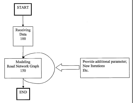
Fig. 1 schematically shows the principle of the present invention on the basis
of a dataflow
diagram. The operational sequence in accordance with the invention may be
started by any
means. Said starting operation may be provided automatically, by means of user
input or the
like. It is contemplated that the operational sequence will be activated or
started, respectively
if new data are received or determined.
In a next operational step 100 receiving of data is provided, wherein said
receiving of data
may be a process which is continuously or periodically repeated. This
operation corresponds
to data acquisition, which is hereinafter described. In a next operational
step said road
network graph is modeled, at 150. All modeling calculations and operations may
be based on
CA 02615185 2007-12-19
WO 2007/010317 PCT/IB2005/002129
13
Bezier curves as described in the following. After all modeling and
calculation steps have
been finished the methodology may come to an END and may be restarted which
corresponds to a new operation according to fig. 1.
It is contemplated as well, that the modeling step 150 may receive additional
information
from other entities within the system. This means that new iterations or the
like may be
controlled by means of external processes or operations or even by means of
user input, for
instance. While receiving additional parameters corresponding to information
from said
plurality of vehicles the modeling step 150 may be restarted until a desired
result is achieved.
With reference to fig. 2A to 2C, the system may work as follows. Generally,
there are three
basic processes. The first process, fig 2A, is an initial calculation, which
gives the first result
of a road network graph.
The second process, fig 2B, can be repeated periodically, e.g. once a month.
This provides
the system with a regular update of the changes in the road network system.
Said changes
may either correspond to changes on the road network size (geometry and/or
topology) or on
its statistics (attributes). Other changes which are to be used for update
issues may be
implemented within the scope of the present invention.
The third process, fig 2C, is constantly analyzing current traffic situation.
If a special
situation is detected (with high statistical probability), the system reports
it to the appropriate
recipient (traffic control center, police, etc.).
With reference to fig. 2A the process representing an initial calculation of
the road network
graph is depicted. In a first operational step data collection 200 is
provided. This means, that
a plurality of suitable equipped vehicles deliver/send position information to
a central server,
for instance. It is contemplated that said sending is provided periodically or
even manually.
This means that the achieved data, currently located in a storage of said
vehicle, must be
somehow transmitted to said central server or provider, for instance. In a
next operational
step, 210, calculation of a first approximation of said road network may be
provided, wherein
CA 02615185 2007-12-19
WO 2007/010317 PCT/IB2005/002129
14
said approximation corresponds to an initial road network graph. According to
the first set of
position information a first calculation of an approximation of the graph may
be performed.
This first approximation will correspond to a provisional representation of
the road networlc
and must be of course amended or revised. Next, profiling of roads and/or
junctions, 310, is
provided. During this step some parameters like road direction and/or kind of
junction, and
also other attributes like average speed, for instance, time (needed for
traveling a certain
connection or distance, respectively)or the like may be added which may be
according to step
215 verified. The verification step 215 may provide a first verification of
the first
approximation and subsequently said graph may be steadily enhanced and/or
expanded. The
main difference between step 215 and 225 is the fact that step 215 is
preferably performed on
the whole graph while step 225 is only performed on certain
detected/determined changes.
With reference to fig. 2B the updating and actualization of said first
approximation is
depicted in principle. The data collection step is similar with the
aforementioned step
according to fig. 2A. The suitably equipped vehicles steadily deliver among
other data
position information. Said data may also comprise information about vehicle
type, driver etc.
In a next step 220 a comparison between existing data, included in the
existing graph, and the
newly received data may be provided. As a result a list of changes or even new
roads etc may
be signalized, so that the methodology may be able to actualize said first
approximation. Said
actualization step is depicted with reference to the operational step 225 in
fig. 2B and said
changes may comprise the changes of the graph structures like for instance
omission of
existing roads or adding new ones or even its attributes (for instance
velocity, time, traffic
rules etc. ).
It should be noted that the input for step 220 (fig. 2B) may either be the
result of the
operational sequence in accordance with fig. 2A (or some other graph) or in
the future the
output of the sequence according to fig. 2B and additionally fig. 2C.
Fig. 2C shows an operational sequence according to the present invention
wherein a real-time
analysis of traffic conditions is provided and further reported. As already
aforementioned
data collection, 200, is steadily provided and the system in accordance with
the present
CA 02615185 2007-12-19
WO 2007/010317 PCT/IB2005/002129
invention is able to analyze the existing traffic data. This analysis, 230,
can be based on
probability theories so that a probabilistic and/or predictive traffic
monitoring operation may
be encountered. According to the present invention the results of said
analyzing, 230, may be
further reported to a third party. Said third party may correspond to a
central traffic
5 monitoring institute or even a vehicle or driver, respectively. There are a
lot of contemplated
configurations within the scope of the present invention.
Next the object of data acquisition or collection will be discussed in detail.
The device
located in a vehicle (on-board device) from said plurality of vehicles may
provide its
10 position, using a GPS signal for instance (it could also be any other
similar system, such as
Galileo) and possibly some dead-reckoning devices (e.g. gyroscope) every
second, because it
is usually the smallest time interval that GPS receivers can handle. If the
measurements were
connected by straight lines, they would describe the shape of the road very
well. The problem
achieved is the quantity of these data. That is why compression is needed. If
the amount of
15 the data will be reduced there are few advantages achieved: reducing of
data transfer to the
central server, decreasing of database size, (post)processing time may be
decreased.
It is also contemplated that the shape of the road is described very
precisely, so that the error
does not exceed the width of the road or generally the road geometry.
Therefore, a proper and
substantially lossless compression of the shape is needed.
For this issue Bezier curves of third order may be used to describe the shape
of the road.
Bezier curves are very flexible and geometrically simple to represent. Those
curves can
describe U and S shapes, cusps and loops. Other curves could be used, too like
Bezier curves
of higher order, arcs, polynomials, etc. Another contemplated feature is to
describe other
information data also, not just the shape of the trajectory. Along with it
velocity, engine
rotations, etc. can be described and made available
Generally, the term trajectory relates to describing the journey/trip or
traveling of a vehicle in
a certain environment. This means, according to a trivial description, that
the trip of a certain
car may be represented by a line (curve), wherein each point of said line
describes the actual,
CA 02615185 2007-12-19
WO 2007/010317 PCT/IB2005/002129
16
geographical position (altitude may be included as well) of the vehicle. It is
further
contemplated, that each point on the trajectory will be associated with the
actual velocity,
acceleration of the vehicle or similar which is advantageous for further
calculating or
modeling issues.
Setting the time interval between two logs
The time interval between two logs depends heavily on the shape of the road.
The wording
log relates to storing certain information from said plurality of vehicles.
The on-board device
may log several positional data before sending them to the server. Said
positional data
corresponds to a traveling route (trajectory) of said vehicle. The data may be
sent
spontaneously without storing, or as already mentioned above the positional
data may be
accumulated (main purpose of component 415) and may further be sent.
Generally, a long portion of a highway can be well approximated by a single
curve; while on
the other hand, a winding mountain road has just a short portion of it, which
can be described
by one curve. The time interval is usually longer on main roads. The goal is
to obtain a
description of the road (the path or trajectory of the vehicle) with a minimal
number of
elements and minimal error as well.
Therefore a heuristic approximation may be needed. The on-board device has a
buffer, which
contains a series of consecutive measurements. The length of the buffer is
equal to the length
of the largest time interval between consecutive logs (if measurements have
valid positions -
if the on-board device is not in a tunnel or a garage without a gyroscope).
Advantageously,
the smallest time interval allowed may be set. This way a lower and upper
bound of the
quality of the compression can be achieved, according to the invention.
Further, because not all measurement data are available (said buffer is to
small) a heuristic
approach may be employed to determine the suitable representation of a
trajectory of a
certain vehicle.
CA 02615185 2007-12-19
WO 2007/010317 PCT/IB2005/002129
17
The basic idea is that the measurements in the buffer are approximated by a
curve (for
instance a Bezier curve) in predetermined time intervals such as every second,
for instance. If
the already performed approximation is good enough, we can omit some of the
measurements
to save on the resources for computing the approximation in the future. If the
approximation
exceeds a predefined error threshold, the process must stop and log (store)
the existing curve
with the measurement at the end of it and empty the buffer. This is how we can
ensure a
small (below a predefined threshold) error (not regarding GPS error!) in the
description of
the road. There are also other conditions which trigger logging of current
measurements.
According to the present invention those measurements may be logged, which
have a big,
preferably bigger than a reference second derivative of velocity. At those
points the
acceleration changes most abruptly. The shape of the road changes gradually if
the
acceleration is constant. It is easier to describe the shape of the road
between the points of
maximum second derivative of velocity.
According to the present invention a threshold for the second derivative may
be set. If this
threshold is exceeded at a certain measurement, then a curve to that
measurement (along with
it) can be logged. Thus, a minimal number of elements in the description of
the road are
thereby achieved according to the present invention.
The current (or the last satisfactory) curve and measurement are logged, if
abnormal behavior
of the GPS signal is encountered, such as multipath phenomenon or losing
signal (when
entering a tunnel). In this manner errors or false measurement may be avoided.
Multipath
phenomenon or effect respectively means that GPS signals from the satellites
are reflected or
they may interfere with other signals, such that the data or signal
communication may be
erroneous. In this case the receiver determines the current position
erroneously.
The aforementioned basic idea may be applied on other quantities (e.g.
velocity), and not just
on the shape of the road. Measurements of this quantity are approximated every
second and if
the approximation is not good enough the approximating process may be stopped
and further
the last satisfying approximation may be registered. If scalar quantities
(numbers) are
CA 02615185 2007-12-19
WO 2007/010317 PCT/IB2005/002129
18
observed, it is contemplated to use polynomials instead of curves, for
instance.
Experimental observations are showing that said aforementioned approximation
enables
logging every 30 - 40 seconds (on average) while describing the shape of the
roads accurately
up to a few meters tolerance. Said observations were approximated by means of
Bezier
curves of 3rd order according to the present invention. Otherwise the time
difference can
substantially vary. Generally, the higher is the curve order the longer is the
time difference
between logs (time between two sub successive position logs).
Multipath effect or phenomenon
One of the biggest problems when trying to accurately describe the shape of
the road is the
multipath phenomenon. If it lasts for a short period of time, it can be
detected from
coincidence of: the difference in the direction, reported by the GPS receiver,
and the
direction, calculated from the GPS coordinates, and increased estimated error
of the
coordinates.
If this phenomenon is detected, then the measurements, involved in it, are
assigned smaller
weight than others when said measurements are approximated, according to the
present
invention. Therefore more accurate measurements have more influence on the
shape of the
curve.
It is contemplated that measurements (and curves) are logged or stored before
the
phenomenon occurs. That is because the measurements (and curves) before the
phenomenon
are not corrupted. If the phenomenon does not exceed the maximal time
interval, it is
preferred not log anything until the phenomenon ends. However, correct curves
or
approximations rely heavily on correct measurements. If a multipath effect was
determined it
is contemplated that the taken measurements within this period (during
multipath effect) are
neglected. The same applies also if just the estimated error increases.
CA 02615185 2007-12-19
WO 2007/010317 PCT/IB2005/002129
19
Application of Kalman Filter within GPS devices
Another difficulty arises because a Kalman filter in GPS receiver as known in
the art does
not perfectly work if the speed of the GPS receiver is low. Therefore the
reported GPS
location is drifting whenever the vehicle is stopped. This can be a serious
problem in urban
areas with a lot of traffic jams.
The solution to this problem is not to log anything if the speed of the
vehicle is low (e.g.
under 3km/h). According to the present invention the measurement (with the
curve) may be
logged as soon as it is detected that the vehicle has stopped and right after
it starts. The
measurements with low speed may be discarded, and further any approximating
steps are
inhibited, and just consecutive logs (just before the vehicle stops and right
after it starts) with
a straight curve (line) are connected.
Both of the above described problems are solved if the on-board device has a
dead-reckoning
device (gyroscope), but it increases the price of the on-board device.
Another problem are the boundary conditions; handling the beginning and the
end of
operating, temporal malfunctions, etc.
According to a possible embodiment of the present invention a following
implementation
may be realized. Accordingly, the following quantities every second are under
observation:
- GPS coordinates - position (P(t)),
- estimate of horizontal error (Sigma), calculated by GPS receiver,
- velocity vector, calculated by GPS receiver (WGS84 Azimuth, Speed (knots)),
- velocity vector, calculated from GPS coordinates ((P(t+l) - P(t-1))/2),
- acceleration (from GPS heading),
- acceleration (from GPS coordinates),
- derivative of the acceleration (from GPS heading),
- derivative of the acceleration (from GPS coordinates),
CA 02615185 2007-12-19
WO 2007/010317 PCT/IB2005/002129
- information about the data validity (see next enumeration):
= 0 no heading, no coordinates,
= 1 no heading, coordinates OK,
5 = 2 heading OK, no coordinates,
= 3 heading OK, coordinates OK.
The numbering above is made just by the way of example, and the present
invention is not
limited thereto.
It is also needed to know whether position was calculated by GPS receiver or a
dead-
reckoning device. Additionally, other quantities may also be observed within
the scope of the
present invention.
If velocity vector, calculated by GPS receiver (Vs), and velocity vector,
calculated from GPS
coordinates (Vk), differ a lot, and the error estimate (sigma) rises, a very
probable cause may
be the multipath phenomenon.
A series of these measurements is stored in a buffer. Length of this buffer
(Max) is the
maximal time interval for an approximated curve. A minimal time interval (min)
can be set
for such a curve. However, said interval provides a lower bound for
compression quality and
enables not to log the last measurement in the buffer. Also a measurement that
was collected
up to min seconds before the current measurement may be logged. If a
measurement is
logged, which was collected r (< min) seconds before the current one, then the
buffer is not
completely emptied - last r measurements may remain within the buffer. If a
circular buffer is
used, it is not needed to shift those r measurements to the beginning of the
buffer. Thereby,
the implementation according to one embodiment of the present invention may
store the
starting and current position in the buffer.
Sometime logging a measurement before the current one is contemplated.
Sometimes several
consecutive measurements are needed for discovering a certain phenomenon. For
instance
CA 02615185 2007-12-19
WO 2007/010317 PCT/IB2005/002129
21
five consecutive measurements can be used to calculate the derivative of the
acceleration in
the middle (third) measurement. In the current second the derivative two
seconds ago is
calculated. If that derivative is big enough, the measurement (with the curve)
from two
seconds ago may be logged in accordance with the present invention. The buffer
is then
emptied, only the last 3 (= r) measurements remain in the buffer. The unit
doesn't have to do
any approximating for a few seconds, until there are min measurements in the
buffer. The
usual routine proceeds from then on. The derivative function is smoothened
using orthogonal
polynomials on 5 consecutive measurements.
An additional buffer can be employed, which stores last min approximated
curves, if for
instance the need to log a curve from few seconds ago is desired.
Generally, there are some boundary conditions. The first measurement (with
valid position)
has to be logged. The same holds for the last position, after the engine was
turned off. The
last position outside a tunnel (with valid GPS position) has to be logged. It
is also
contemplated to set a threshold u of how many consecutive seconds the GPS
position has to
be invalid to mark it as a beginning of the tunnel. The purpose is to discard
very short tunnels
or errors, noise in GPS receivers. After a measurement has been logged as the
beginning of a
tunnel, the first measurement with valid GPS position as the end of the tunnel
must to be
logged. If the on-board device doesn't have a dead-reckoning device, these two
logs are
connected by a straight curve, a line. The time interval between the two logs
can be more
than Max in this case only. If the on-board device has a dead-reckoning device
(gyroscope),
the logging procedure inside the tunnel is the same as usually.
The next section describes choosing the logging step (log) in accordance with
one
embodiment of the present invention. For instance, the following three
quantities (values) are
observed at a given time t: A(t) = size of derivative of acceleration
(scalar), V(t) = difference
of velocity vectors IVs-Vkl (scalar representation), S(t) = Sigma, estimated
error (scalar
value).
If A(t) exceeds a predefined threshold, then the measurement is a member
(subject) for
CA 02615185 2007-12-19
WO 2007/010317 PCT/IB2005/002129
22
logging. If a weighted sum of V(t) and S(t) exceeds another threshold (due to
possible
occurrence of multipath effect), then:
= If (t- 1) > min then the previous measurement should be logged (to not
corrupt the current
curve approximation), else
= If t < Max, the t-th measurement should not be logged (because the multipath
effect may
be terminated soon, and thereby correct ending measurements and curve
approximations are
possible).
It is desired to find and log a measurement with a big derivative and small
multipath and
error estimates. There may be two boundary values: minimal time to the new log
(min),
maximal time to the new log (Max).
With reference to fig. 5 an automat in accordance with the present invention
is provided. For
example: (L stands for LOG, 530, m, 510 is a measurement at every second).
This is an automat (according to fig. 5) which has a temporary state:
Lmmmmmmmmmmmmmmmmmmm,,, = L+c*m
Said automat performs a basic Loop:
L+c*m
If the number of current measurements c is more than min and less than Max
then
if the trigger is set at t, t> min, t < Max, (c-t) < min, the measurement t in
the series is logged
and the series is emptied to L+(c-t)*m
Else
L+(c+l) *m
goto Loop
CA 02615185 2007-12-19
WO 2007/010317 PCT/IB2005/002129
23
The trigger (520) may consist of several parts:
A) if the second derivative of the velocity is bigger than the prescribed
threshold, this
means the measurement at tl:= c-2 is a candidate for a log;
B) if the multipath phenomenon probably occurred at t2:= c-1 (difference
between
directions is large and estimated error has increased), then
1. if m(t2-1) had no multipath and (t2-1)> min, then m(t2-1) is a log
candidate
else (otherwise)
2. if t2 < Max, m(t2) should not be the logged;
C) if the calculated curve at c doesn't fit the measurements well enough, and
the curve
at t3:= c-1 does, then m(t3) is a candidate for a log;
D) if other scalar quantities (velocity, for instance) are observed, and the
approximation of the measurements is not good enough, then m(t4) along with
the
curve and approximating function of this quantity should be logged, t4:= c-1.
Then the
minimum tm of candidates for logging (tl, t2, t3, t4) is chosen. The new log
is m(tm)
with the corresponding curve and possibly approximating functions of other
quantities.
When trying to fit a curve to the measurements of positions, they are weighted
with the
weight, which decreases with increased multipath probability. If the fitting
is done in fixed-
point arithmetic, some special measures have to be taken.
There are also some other contemplated boundary conditions: the first valid
position after
starting is logged; the last valid position (when turning a car off) is
logged; the last
measurement before a tunnel (before GPS positions turn invalid) is logged; the
first
measurement after a tunnel is logged.
Bezier curves
A short introduction to Bezier curves of 3rd order follows, wherein
advantageous adaptations
in accordance with the present invention are provided.
CA 02615185 2007-12-19
WO 2007/010317 PCT/IB2005/002129
24
Those curves are generally defined by 4 control points P0 to P3. The curve
lies within the
convex hull of the control points. The curve starts in the first control point
and ends in the
last. Starting direction of the curve equals the direction between first two
points and ending
direction equals the direction between the last two points.
Numerically, Bezier curves are defined with Bernstein polynomials over control
points Pk.
N ~
B(t) pk N' tk (1- t)N-k ;0 _< t<_ 1 describes the curve, parameterized by t.
k=o k! (N k) -
Said curves can be split by means of the De Casteljau algorithm (not shown).
Another issue is to fit the Bezier curves in accordance with the received or
provided
measurements. If mobile units (or devices) have a fixed-point digital signal
processing unit,
only fixed-point arithmetic may be used, therefore the computational error due
to the fixed-
point computation has to be minimized or avoided. A first improvement in
accordance with
the present was to include CORDIC (Coordinate digital computing) algorithms to
compute
norms of vectors (or curves), etc.
The second improvement in accordance with the present invention is to choose a
bounding
box (not tight) of measurements and normalize them according to the bounding
box
size and range of numbers (fixed-point arithmetic).
The state of the art teaches only to adjusts just the length of the tangent
(control) vectors of
the curve (between the first and the second pair of control points), but it is
needed to modify
the direction, as well.
The following shows how more flexibility of the shape of the fitting curve may
be achieved
in accordance with the invention.
The following definitions are made:
CA 02615185 2007-12-19
WO 2007/010317 PCT/IB2005/002129
V = Vo + a1t1 + ,fl1t1P
V2 = V3 + a2t2 +/~ / 2t2P
5 wherein V; are control points of the curve, and t; are control (tangent)
vectors at the ends of
the curve, tjP is perpendicular to tj.. aj stands for the correction of length
of control vector;
and fli stands for the correction of direction. The solution for the Qj values
is similar with the
solution for aj , which is described in the prior art.
The fitting procedure may be iterated in a loop and the loop may comprise two
steps: first
10 adjusting the length, and second adjusting the direction of the control
vectors.
According to the present invention measuring of distances by means of GPS
signals or
information, respectively may be provided. It is possible to measure the
length of a route with
the help of the GPS system. If measurements are available, which are taken
every second
15 (some may be missing), it is contemplated to sum the distances between all
the consecutive
pairs and get a very accurate estimate of the actual length. If the velocity
is low (e.g. under 3
kin/h), the measurements may be discarded according to one embodiment of the
present
invention.
20 Storage of data
All data and information as used in the present invention and received from a
plurality of
vehicles may be stored at a central location (server) and may be later
analyzed in a couple of
stages for instance to achieve the desired result. These data entries are
preferably called raw
25 data. Raw data may include at least one of : position, speed, heading
(direction), time of data
acquisition, but can include also: a description of the curve (trajectory), a
description of the
function of other quantities (velocity etc.), horizontal accuracy estimation
of position
received by position receiver, number of (GPS) satellites with good signal,
data from other
vehicle sensors (temperature, weight) etc. Raw data may be stored so that the
ride (travel or
trajectory) of a vehicle is stored as a separate set of data, but however the
identifier of the
CA 02615185 2007-12-19
WO 2007/010317 PCT/IB2005/002129
26
vehicle might be encrypted (hashed) or even not present in order to maintain
privacy.
Vehicle data may comprise two attributes to further help for identifying route
data: type of
vehicle (passenger car, van, truck, bus, motorcycle, construction vehicle,
tractor, ...), type of
service (passenger, police, construction, taxi, municipality bus, military,
farm, ...).
Those above mentioned two attributes may help to differentiate the public road
network and
the roads used by special types of vehicles (such as tractor) and the roads
used by particular
service with extended or limited rights (police, military, taxi, etc.).
Road network computation
Raw data is first analyzed to provide vectors (curves) representing roads and
organized into a
directed graph (as in well known graph theory in mathematics). This process
needs a small
amount of very accurate measurements (as the traditional approach in
geodetical praxis) or a
large amount of less accurate measurements, which produce high accuracy, when
averaged.,
According to the present invention the focus is set on the second situation.
The graph edges are the streets. and the graph vertices appear when several
roads are
connected. Geometrically nearest vertices represent the junctions. All the
operations from
here on are therefore derived from standard graph theory. The resulting graph
is the basic
road network graph. Simply put, the analysis turns raw data from many vehicles
which have
traveled the same way into one vector (curve) representing the road traveled.
This process is
not at all trivial. It is contemplated to note that the data might not truly
represent the traffic
rules since some drivers might violate them.
The first goal is to produce a 2D map. It is also possible to include
information about the
height above the sea level, if the measurements are accurate enough. It is
necessary to
compute two properties of the road network properly: geometry, meaning
accurate positions
of road axes, topology, meaning correct connections between the roads.
CA 02615185 2007-12-19
WO 2007/010317 PCT/IB2005/002129
27
Geometry is basically computed by averaging the trajectories of vehicles,
which were on the
same road. Topology is basically computed by checking which trajectories
connect which
roads. There are several strategies for roadmap calculation. Two basic
approximations are
described: a local and a global version. The distance between sampled points
of roads at both
of them may be defined.
The local version is more locally (in terms of distance) focused. It
progresses locally by
prescribed distance between sampled points. It focuses on the density of
resulting graph. This
calculation of the map is based on two steps: calculation of road sections and
calculation of
road junctions.
The basic operation is calculating a single curve between two sampled points,
corresponding
to an averaging of the measurements. According to experimental tests a
distance of 100 m
between two sampling points was chosen. According to the present invention it
is preferred
to describe sections of a road between two sampling points as a straight line
if the distance
between the points is around 20 m. Thereby, the produced error is not
significant and the
road section is suitable represented.
According to the present invention, Bezier curves may be used for representing
vehicle
trajectories and their computed averages in the graph, because of their
numerical stability and
geometrical flexibility and clarity.
Averaiiing of Bezier curves
This procedure is part of the present invention and is used for calculating
the geometry of the
roads, but it could be used for other purposes, too. According to the present
initial
observation a plurality of trajectories provided by a plurality of measuring
vehicles is
provided. Each trajectory of each vehicle is described by consecutive Bezier
curves, in
accordance with the present invention. These curves usually have different
lengths. To obtain
the exact geometry of the road axis or road subsection, respectively, an
averaging step of all
present trajectories may be provided, according to the present invention. The
averaged curves
CA 02615185 2007-12-19
WO 2007/010317 PCT/IB2005/002129
28
have to be short enough to describe all the road network details accurately
enough.
Accordingly, averaged Bezier curves, which were less than 100m long, were
employed.
The next section will describe the averaging step of a set of trajectories
described by Bezier
curves in accordance with the present invention. An object is to average
several trajectories.
Firstly, a starting and an ending point for each averaging may be chosen.
Starting and ending
point from which to which the trajectories are averaged can also be set as a
line, that is
perpendicular to the trajectories, according to the present invention.
It is assumed that average trajectory between the starting and ending point
(line) can be
sufficiently well described by a Bezier curve according to the invention.
Before averaging the given curves at points, closest to chosen starting and
ending point (or
lines) may be split. Thus, a result according to subsections of trajectories
is obtained, which
are very similar.
There may be several ways for performing said averaging, according to the
invention:
1. If all the subsections between starting and ending point are described by
single
curves, it is preferred to simply average the control points of the
subsections.
Otherwise, another way of averaging may be chosen, which is described next.
2. Averaging:
= Starting and ending coordinates in these subsection
= The velocities (lengths of control vectors) in these starting and ending
coordinates
= Lengths of subsections
= Time differences of each subsection between the starting and ending
coordinates Thus, enough data to guess the trajectory is provided (see next
section).
3. Fitting a new Bezier curve to measured positions (coordinates - points on
the
CA 02615185 2007-12-19
WO 2007/010317 PCT/IB2005/002129
29
original curves) in this subsection (see section about data compression). If
there are
not enough measured positions, it is preferred to arbitrary add points on
curves.It
should be mentioned not to use positions which could have a big error. Using
positions, which are very close to starting or ending point on each
subsection, may be
unfavourable, because the error of these positions has more influence on the
shape of
the curve - thereby, sometimes small loops may appear.
Guessing or determininEF the tralectory
In case the trajectories are not described with Bezier curves, but
measurements are close
enough, the trajectory can be guessed and described with guessing a Bezier
curve as follows.
Without compression, the data from the vehicles consists of positions,
directions (headings)
and velocities in these positions and time and distance between consecutive
positions. For the
roadmap calculations, it is necessary to have information about what the
trajectory between
these positions was. If the recorded distance matches with length of said
guessed curve, it
may be considered as satisfactory.
According to the following values: a starting and ending point of the
trajectory, the vector of
velocity at the beginning and the end, the distance, time, which is needed to
travel this path, a
step of guessing the trajectory in between said points may be provided.
According to the present invention the trajectory may be guessed or calculated
by means of a
Bezier curve of 3rd order. The starting and ending point are fixed and they
are the first and
the last control point, as known in Bezier curves techniques. Next the
position of the middle
of two control points is to be determined. The second control point is
obtained from the first
with the velocity vector added, and the third control point is obtained from
the last with the
velocity vector subtracted. Then, normalized velocity vectors are multiplied
with an
appropriate factor (e.g. speed [m/s] *time [s]/3) for the first approximation
of these points.
Then the length of the curve may be computed and it may be adjusted if
necessary (see next
section).
CA 02615185 2007-12-19
WO 2007/010317 PCT/IB2005/002129
Adiusting the length of Bezier curve
5
This is useful when an approximation of the curve with correct directions is
given. Length is
a contemplated additional factor, if only two degrees of freedom are left -
length of starting
and ending vector. This procedure changes both vectors uniformly, because
velocities usually
don't change very abruptly. If the curve is shorter than the actual data, it
is preferred to
10 prolong the velocity (control) vectors; and if it is longer, it is
preferred to shorten the vectors,
and repeat the process. When the actual and the required length are close
enough then the
operational sequence may stop. Nevertheless said adjusting is provided in an
iterative manner
so the desired result may be obtained after a certain number of operations.
15 Calculation of road sections
This is the step where sections of roads between the road junctions may be
calculated. This
step focuses on the geometry of the road network. According to the invention a
starting point
is randomly chosen and the operational sequence continues with the above
described basic
20 operation along the measurements until the measurements separate. This is a
signal for a
junction. It is also envisaged to continue the section backwards in order to
acquire the full
section between the junctions.
Calculation of road iunction
Calculation of road junctions is a separate step, because the geometry and the
topology of the
road network is the most complicated in the junctions. The emphasis in this
step is on the
topology. Measurements (logs or parts of curves) are attributed to
corresponding road
sections. All the measurements that lead from one road section to another are
collected. They
are like a flow from one pipe to another. The already described basic
operation is applied on
the collected measurements. It is preferred to only connect the two existing
sections with the
CA 02615185 2007-12-19
WO 2007/010317 PCT/IB2005/002129
31
newly calculated 'flow' section. The same is done for all the combinations of
two road
sections, which are connected by the measurements.
The same procedure can be repeated on the resulting graph or performed on
several graphs
from different sources (government institutions, road constructing companies,
etc.) instead of
only on the measurements from our system.
Global calculation
The global version is more oriented towards geometric accuracy. It requires
long paths (at
least 500m) within the measurements. It also allows a partial graph
complementation.
Calculation of a road section
First the starting and ending point of the road section is chosen. Then all
the measurements
going from the starting to the ending point and having approximately the same
length are
collected. The basic operation, described above, is applied on the collected
data. A small
portion (100-500m) of the section at the endpoints may be discarded to avoid
less accurate
results.
Appending the road section to the existing graph
When a road section is already calculated, it may be appended to the existing
graph. Only the
subsections may be appended, which are not included in the existing graph.
Calculating the graph
Further, it is needed to repeat the first two steps, until all of the
measurements are used.
Firstly a start with an empty graph is provided and the final result is the
graph of the part of
the road network, which was sufficiently covered with measurements.
CA 02615185 2007-12-19
WO 2007/010317 PCT/IB2005/002129
32
Experimental results
Experimental observations show a high accuracy of the method in accordance
with the
present invention. Of course the accuracy depends on the number of
measurements taken.
There are a few percents of errors in topology of the calculated graph. The
errors appear
mostly if there are parallel roads, closer than twice the error of GPS
(typically 30 meters)
apart, and in complex junctions. They are due to inaccuracy of the GPS system
and too long,
fixed time interval between recorded logs. The expectation is that the
percentage of errors
may decrease when the methodology will use compressed measurements (the
dynamic time
interval between logs with the fitted curve) and include the gyroscope in the
on-board unit.
Also the speeds and waiting times are quite accurate.
Profiling the network
Further a main operational step in accordance with the present invention may
be
identification and profiling of the junctions. Several vertices in the basic
road network graph,
which are connected and are close together, can be merged into a more complex
structure of
a junction. Basic road network graph is used together with raw data to analyze
the junctions
in order to define the following (and possibly others, too) properties of a
junction: the traffic
rules (which roads are coming into the junction, which go out, and which are
connected; are
there any traffic lights; which roads have priority, etc), the traffic pattern
(which roads are
major in a junction, what is the expected time to cross the junction), type of
the junction (X
or star type, roundabout, exits (such as from highway), etc.), how many lanes
go to a specific
direction, etc. The data in second line can be used to differentiate major
roads from minor in
order not to distract the driver when navigating in an area with too many
minor roads.
The data is once again stored as a graph with additional auxiliary data
structures (matrices,
etc.).
This data would basically suffice to navigate a driver.
CA 02615185 2007-12-19
WO 2007/010317 PCT/IB2005/002129
33
Furthermore profiling of the roads is provided, see also fig. 2A to 2C. Having
many vehicles
traveling the same roads, there is a lot of statistic data available, such as
average speed,
average speed in a time of a day, etc. These data are used to profile the
connection (road),
which is to assign the following attributes to every connection: direction of
the streets/roads
(one-way, two-way), the distance, average speed or average time to travel the
connection
(depending on the hour of the week, or similar), validity of statistic data
(to verify there is
enough data available to tell something substantial about the traffic on a
particular connection
/ road), average* quantity of the traffic (relative, regarding other roads),
type of the road
(highway, street, local road, number of lanes, etc.), the time when it was
(most recently) used,
and possibly some others, too.
This is done using the road network graph and raw data. The process was
described above in
greater detail with reference to fig. 2A to 2C and in the description.
A contemplated advantage is that (thanks to the curves and fitted velocity) it
is possible to
provide the velocity at every point on the trajectory (travel) of the vehicle.
Therefore it is
possible to tell what the vehicle velocities were exactly when traversing a
cross-section of the
road. Other quantities (values) may be fitted analog to the aforementioned
example regarding
the velocity according to the present invention.
Generally, said profiling operation may be performed by using already stored
traffic data
anytime and on any graph (manually generated or even from other sources).
If it is observed when the roads were used, it is possible to find the roads,
which were not
used by (equipped) vehicles for a long time. It is very probable that such
roads are no longer
used and can be (usually after some checking) erased from the roadmap
database. This is a
very efficient way to detect auxiliary roads (used to build a highway or at
other construction
sites) or other roads which have ceased functioning (see section about
updating the network).
The result is a digital road network system which is geometrically and
topologically correct.
It contains statistic data which enable very accurate fastest-path navigation
due to past
CA 02615185 2007-12-19
WO 2007/010317 PCT/IB2005/002129
34
experience of all vehicles enrolled into the scheme. However, this data must
be checked
manually (with specially equipped verification vehicles) to avoid possibly
proposing
prohibited turns to the drivers.
Verification
Digital road network system from the previous section should be traversed by
verification
vehicles, equipped with special equipment, to verify that the database (road
graph)
corresponds to the actual road system. Since the road system is already
digitalized, it is
possible to advise the driver exactly which way to go in order to achieve the
least possible
route traveled. Optimization can be done using one of the well known
principles of route
optimization (such as Chinese postman algorithm known from graph theory).
Of course, some correcting can be done manually, before the specially equipped
vehicles
head for checking. This can decrease necessary costs even further. Another
saving is
achieved if these vehicles are only sent to these roads and junctions, which
were calculated
out of too few or not enough accurate data. This is especially useful when
changes to road
network graph are detected.
This represents huge advancement over other systems where there is no road
system (or at
least not topologically ))ordered in any way) before the verification.
Whenever there is an
inconsistence between the actual and the digital road network system the
driver must enter
that data into the special equipment which then proposes new route. The
changes might be
permanent or temporary (with lesser effect on the digital road network
system). This process
makes verification by far faster and cost efficient.
Verification actually adds or removes some streets (edges in the graph) and
changes the
connections, the topology of it. The roads that might have never been traveled
by the vehicles
are not necessarily added manually. If necessary, the road is traveled a
couple of times by
verification vehicles in order to get it into the system.
CA 02615185 2007-12-19
WO 2007/010317 PCT/IB2005/002129
A very contemplated aspect is that said vehicles have to check the height and
width of
tunnels or other obstacles, because such data is very difficult to acquire
otherwise. The result
is a digital road network system that can be used for navigation.
5 These vehicles can be equipped with vibration sensors to determine the
quality of the road or
other sensors, which might not be directly linked to road network, but gather
other useful
information, like mobile network coverage, or similar.
Updating of the road network graph
Since the on-board devices are sending data continuously, the described
process can be
repeated several times corresponding to an updating step. The aim is to be
able to detect new
sections or changes to the road network very quickly and verify the very same
sections
through the described process very quickly. Since newly processed raw data
most probably
turn out the same streets and since some of them have been proven wrong by
verification
process it is contemplated to pay attention to those and tag them accordingly
to help the
updating process avoid sending the verification staff unnecessarily.
Generally, said updating operation may be performed by using said traffic data
anytime and
on any graph (manually generated or even from other sources).
Raw data, sent by the on-board devices, are used for several purposes. Raw
data about the
trajectory of the vehicle is described with curves. For every section of the
trajectory,
corresponding road sections and junctions are found in the database. If they
could not be
found in the database, this section of the trajectory is marked and saved for
road network
update.
At the above-mentioned step the curve similarity is a contemplated issue. It
is provided to
find similar subsections of the curves in order to be able to identify, when a
certain vehicle
was on a certain road or road part, respectively. The sections which are out
of the graph are
saved and accordingly marked. When a calculation for update was started the
geometry,
CA 02615185 2007-12-19
WO 2007/010317 PCT/IB2005/002129
36
topology and profiling can be done according to said sections according to the
present
invention. This is an improvement of the state of the art methodologies that
only detect the
changes without any further processing steps.
Thus, said approach for curve similarity may be used for other purposes, like
electronic toll
systems, for instance because it enables the exact determination where the
vehicle is exactly
located, or shape recognition in general.
The main server compares the received data with stored traffic information
about road
sections. If that information differs substantially, this is a reason for an
alert. Typically, this
would suggest a traffic jam. If several vehicles send similar information
about the abnormal
traffic on a specific road section, the alert is even more convincing. This
operation is
performed within a couple of minutes. The data is also used for post-
processing. The first
step is to update the traffic statistics information regarding road sections
and junctions. Road
sections, corresponding to new data, are found in the database and their
information is
updated.
Road sections also have information about the times of traversal. A regular
check (e.g. once a
month) finds roads, which are not used any more, and can be omitted from the
database (after
some checking). On the other hand, the sections of trajectories, which had no
corresponding
roads in the database, are used for calculation of new road sections, which
are then added to
the database.
Bezier curve similarity
To compare two curves, for instance, they have to be aligned first. This
alignment may
include translations, rotations and scaling. Similarity between curves is
computed out of
distances (Euclidean or others) between corresponding pairs of control points,
in accordance
with the present invention. This computation can be summation, averaging,
minimum,
maximum, etc. It depends on the nature of the problem.
It is true that similar compositions of control points yield similar curves.
The opposite is not
always true - similar curves can be constructed with very different
compositions of control
CA 02615185 2007-12-19
WO 2007/010317 PCT/IB2005/002129
37
points. The problem is in parameterization. This can be illustrated by an
example of a straight
curve, a line. The middle two control points of the line can be placed
anywhere on the line
and the curve will have the same shape, only the parameterization will differ.
If only the shape of the curve is contemplated, not the parameterization, one
can
reparameterize the curves before computing the similarity. Reparameterization
can be done
by sampling points on the curves and then fitting them with another curve (see
section about
fitting Bezier curve to an ordered set of points). This curve should have
basically the same
shape as the original one.
Finding similar subsections at a pair of curves
This procedure is contemplated for roadmap computation and traffic statistics
update. A long
curve can describe the trajectory of a vehicle. Roads are also described as
curves. It is
contemplated to determine when the vehicle was on one or another road, which
part of its
trajectory corresponds to which road.
A definition of similarity of curves is needed first. For comparing the curves
one can use
= Absolute criterion. In this case the minimal length of the subsections of
the curves that
are compared should be set. Short pieces of curves can always be similar,
because
their control points are close together. One can also set some criteria about
the angle
between the curves (between vectors, connecting the starting and ending point,
for
example).
= Relative criterion.
The curves can be aligned at the beginning. First a sub curve of the second
curve is selected,
with the endpoints closest to the endpoints of the first curve. Then the
following procedure,
according to the present invention, is recursively repeated:
If the curves are similar, they are recorded as similar parts. Otherwise the
first curve is split
(on the middle) and the second curve is split closest to splitting point of
first curve. Both
pairs of sub curves are compared.
CA 02615185 2007-12-19
WO 2007/010317 PCT/IB2005/002129
38
At the end the pairs of similar sub curves are reported.
The described system according to an embodiment of the present invention is a
very effective
way to generate and profile digital model of road network. This kind of data
is very
contemplated in an era of mass transit. Instead of building a special
infrastructure to cope
with the traffic analysis the proposed system uses relatively inexpensive
equipment for the
vehicles which serves for other useful purposes (navigation, messaging, fleet
control in
general), a public wireless data network (GSM/UMTS, CDMA) and a special
computer
system to analyze huge volume of data. That kind of principle is foremost
useful for
developing countries which have quickly evolving road system and which lack
enough
organization skill to operate complex operations to make a digital model or
road network
otherwise. There are a lot of possibilities of how this system could also be
used.
The on-board devices are capable of navigating the driver if they have a user
interface,
typically a keyboard and a screen. A request for navigation can be sent to the
server, which
also has current information, the server sends the results back to OBU, which
presents the
results and guides the driver.
The most valuable data is continuously updated digital road network model
data, along with
the traffic statistics, which helps navigation companies to update their
routing products much
faster. This is true both for countries having already mapped roads (EU, US)
and especially
for countries having poor digital models of road networks (Russia, China,
India).
The profiled road network model helps road infrastructure planners to increase
throughput
where it would have most effect. The model includes traffic flow data not just
in general but
also for a particular time in day, day in week and so on.
A common question would probably be: how much time is needed to get from point
A to
point B? Every trip, trajectory can be described as an ordered set of
measurements, curve.
They can be marked with a trajectory identifier. Then all measurements
(curves) that are
close to point A and all those which are close to point B are collected. If a
measurement
(curve) in the first set has the same trajectory identifier as a measurement
(curve) in the
second set, then the trajectory between those two measurements (curves) is
extracted. All
CA 02615185 2007-12-19
WO 2007/010317 PCT/IB2005/002129
39
such extracted trajectory subsections represent the traffic flow from point A
to point B. They
can be further analyzed.
Since routing data is based on statistical data (which is updated on a daily
basis) it is perfect
platform for optimization applications such as: multi-load, multi-delivery
optimization,
just-in-time delivery, optimization of arrival variation, optimization of
public transport
network.
In the case that the road network graph comprises timing details defining the
time needed to
travel the connections (road sections) of the graph it is contemplated to
calculate the fastest
route on a time detail basis. Said time details may characterize the traffic
in dependence on
the day of the week or generally the day time, for instance. For instance if a
user will input
the starting time the methodology in accordance with the present invention
will determine the
fastest route and will provide the user with the resulting journey time or the
like. It is also
contemplated that the user may input the desired arriving time, so that the
algorithm will
determine and provide the starting time etc. This could be achieved in the
following way;
every connection of the graph should have appended information about how long
does it take
to traverse it according to timing details. When searching for the fastest
route, the visited
elements have to include timing details, too.
Such a system could easily be modified to work as an electronic tolling
system. The main
advantage is that, using all the knowledge, it would not require a complete
map of road
network. Trajectories are measured as curves and the probability of
identifying the right road
with the use of a curve is far bigger than just using a single GPS coordinate
measurement.
If the shape of the curves is compared, a determining of the actual location
of the vehicle is
much easier and more accurate.
Fig. 3 shows the principle of a system according to an embodiment of the
present invention.
The plurality of vehicles is representatively depicted by two cars, which are
equipped with
suitable on-board devices. Said devices are adapted to receive GPS signals for
instance and
CA 02615185 2007-12-19
WO 2007/010317 PCT/IB2005/002129
determine the geographical information of each vehicle respectively. According
to this
embodiment, but not limited thereto a GPS satellite 300 may be used. Said
satellite 300
provides each on-board device of said measuring vehicles with a position
signal. The on-
board device may store all positional data or alternative it may periodically.
send the data to a
5 central server 301 at a certain location 302. The server 301 is suitable
equipped with a
antenna 303 and of course with means for receiving signals from the plurality
of measuring
vehicles. All received information may be stored on the server unit or for
instance on other
suitable storage means. The methodology in accordance with the present
invention may be
run on said server 301 which serves according to this embodiment as a working
(calculating)
10 station as well. Additionally a database server may also be implemented to
support said
server 301 for storing the large amount of received positional data.
The trajectories of both vehicles, in this case, are named as Road A and Road
B, wherein said
roads show two junctions (Junction A). By means of said received information
the server
15 may store all trajectories from each vehicle respectively. Further,
according to the present
invention all trajectories from one or more vehicles traveling (driving) a
similar road may be
averaged to get accurate road models.
The area 380 shows by the way of example a part of a road assigned with some
dimensions
20 like length L and width W. According to the present invention all road
sections part of the
road network graph may be characterized by their parameters like: width,
length, direction,
altitude etc. Other parameters may be inserted additionally like: average
speed, category of
the road or similar. The average speed may be defined according to the hour of
the day or
day, for instance. Additionally said parameters may comprise statistical
information like
25 traffic statistics. Said statistics may be provided from third parties for
instance and may
comprise traffic jam information or even traffic statistics, like number of
cars or estimated
values etc.
Fig. 4 shows an embodiment of an on-board device which may be installed in a
measuring
30 vehicle. Said on board device comprises a CPU 400 that is adapted to
control all operations
of said device. The CPU 400 may interconnect all further modules or
components,
CA 02615185 2007-12-19
WO 2007/010317 PCT/IB2005/002129
41
respectively within said on-board device, according to fig. 4. Said on-board
device
comprises: a removable storage 425, a position signal receiver 405, further a
dead-reckoning
module 410, a communication interface 420 and an internal memory module 415.
Said communication module 420 may be adapted to communicate with the central
server by
means of a certain data channel. It is contemplated to use different
techniques like GSM,
CDMA, UMTS, TETRA, General Radio Interface or the like.
Fig. 6 shows the principle of averaging several trajectories, represented by
Bezier curves, to
an averaged curve. Each trajectory A, B and C is described by a Bezier curve
approach on the
basis of positional data information 60.
In the illustration according to fig. 6 only the principle of the calculation
according to the
invention is depicted. Actually the trajectories of each vehicle are nearly
identical with the
real shape of the road or street under observation but for the sake of clarity
a considerable
difference between trajectories is shown.
Generally, each trajectory of each vehicle may be described by consecutive
Bezier curves.
These curves usually have different lengths. For obtaining the geometry of the
road axis, it is
needed to provide an averaging step on said trajectories corresponding to said
plurality of
measuring vehicles.
This means that the shape of the curves depends on the received positional
data from said
plurality of vehicles. In this embodiment only three trajectories are depicted
but it is possible
to perform the methodology in accordance with the present invention on a
plurality of
vehicles.
The positional data 60 may include geographical position data (coordinates) of
said
measuring vehicles, wherein said coordinates are used to describe the Bezier
curves. The
mathematical calculations of said Bezier curves are described above in detail
in the
subsection "Bezier Curves".
CA 02615185 2007-12-19
WO 2007/010317 PCT/IB2005/002129
42
In this embodiment the positional data is provided on a time basis, this means
each At
positional data will be somehow transmitted form said plurality of vehicles.
The timing may
vary and is not fixed according to the present invention. Thus, it is
contemplated to choose a
large value for said time if the route has no curves and in areas where the
road has a lot of
curves or junctions the time may be accordingly adapted. That is the value is
decreased
resulting in fine measurements of the trajectory shape.
Thereafter the trajectories A, B and C may be used to calculate an averaged
curve 65 which
corresponds to the existing, physical road shape. According to the invention
it is
contemplated to average a large amount of trajectories (Bezier curves) to get
the desired
result. The algorithm in accordance with the present invention allows an
effective averaging
of Bezier curves and from the standpoint of the computational power it is
advantageous and
economical.
Hence, the present invention attains automatic calculation of road network
graph, wherein
input is usually formed by measurements from many vehicles (included in the
present
system), but the same methods can be performed on some other measurements or
also on
existing graphs of road network.
Further, the invention attains automatic profiling of the network, wherein the
input is a graph
and the raw data. The graph is obtained as outmined in the specification above
(calculated as
above, bought from someone, etc), and the raw data are usually measurement
from the
vehicles in the present invention system, but it could be also from somewhere
else (e.g. road
names, speed limits from government agencies). In another aspect the procedure
is basically
about pasting (and recording) the raw data (some of its parameters) onto the
graph. The shape
of the curve is a contemplated aspect for identification of corresponding road
and trajectory
sections.
Further, automatic updating is basically corresponding to the above, wherein
recognizing the
sections of trajectories that do not correspond to any road sections (and vice
versa - road
sections that were not traversed by any vehicles lately) is of particular
importance. When
CA 02615185 2007-12-19
WO 2007/010317 PCT/IB2005/002129
43
collecting a sufficient amount of them, one can calculate new parts of the
road network
graph. One aspect is that one can do that on any graph, which means one can do
the updating
(profiling also) on existing road graphs e.g. for EU, USA, Japan, etc.
Finally, a verification method is provided, wherein a final approval of data
is encompassed.
The advantage is that the present invention has an approximation (calculated
graph) and can
optimize the routes for the verification vehicles, which means a substantial
saving.
Further a method for finding a fastest route within a road network graph is
provided. Said
finding is based on timing details which are part of the elements of said road
network graph.
However, a user of a suitable equipped vehicle may use the information
provided by the
network graph according to the present invention to determine (find) the
temporally fastest
route. For instance if a user wants to reach a certain address at a given time
the methodology
in accordance with the present invention will determine and calculate the
fastest route. Said
determination is based on the information included within said road network
graph, which
was profiled also by using timing details.
Furthermore, a method for inspecting the traffic flow, recorded by said
information data, is
provided which may be applicable for road infrastructure planning for
instance. That is, the
continuously adapted road network graph delivers information about traffic
condition and
may be used for determining crowded road subsections and/or junctions and the
like.
Even though the invention is described above with reference to embodiments
according to
the accompanying drawings, it is clear that the invention is not restricted
thereto but it can be
modified in several ways within the scope of the appended claims.