Note: Descriptions are shown in the official language in which they were submitted.
CA 02617125 2008-01-08
TITLE: METHOD AND SYSTEM FOR GEOPHYSICAL DATA
ACQUISITION ON AN AIRSHIP
FIELD OF INVENTION
The present invention relates to methods for pr-.).cessing geophysical survey
data,
and more particularly, to acquiring geophysical survey ,(lata on a non-fixed
wing aircraft.
BACKGROUND
Gravity surveying is one technique in modern exploration for mineral and
petroleum commodities. For example, detection of geophysically significant
subsurface
anomalies potentially associated with ore bodies or hydrocarbon deposits can
be made
using gravity surveying techniques since the existence of gravitational
anomalies usually
depends upon the presence of an excess or deficit mass associated with the
deposit. The
presence of the deposit can be associated with a gravitational anomaly of the
body. A
body of ore can be 0.00002% of the normal Earth gravity field, for example.
This
relatively small effect is normally measured in units of milli gals (mGal),
which is the
unit for the free air and Bouguer gravity field measurements (1mGal is
equivalent to 104
na/s2).
Many gravitational measurements have been Made using instruments of the
LaCoste/Romberg type that are essentially ultrasensitive spring balances
detecting a
small difference in weight caused by the gravity anomaly. The measurements are
subject
to a wide variety of environmental influences, and measurements should be
performed
1
CA 02617125 2008-01-08
relative to a standard point that is used regularly during the survey as a
fixed reference for
removal of drifts in the instrument.
In addition, some large scale geophysical Prqspecting has progressed towards
gradiometry. In principle, measurement of a gradieq of a gravity field over a
known
baseline allows accelerations due to motion of the platform itself to be
cancelled out.
Gravity gradients are the spatial derivative of the gravity field, and have
units of mGal
over distance such as mGal/m. The standard unit of gravity gradiometry is the
Eavos
(E), which is equal to 10-9/s2 or a tenth of a mGal over a kilometer (e.g.,
gradient
signatures of shallow Texas salt domes are typically 50-100 E).
One type of gradiometry that has been used is three-dimensional Full Tensor
Gradient (3D FTG) technology. FTG technology was developed by the US Navy and
later adapted to the Oil & Gas industry to complement seismic technology and
provide an
independent method of imaging underwater salt and basalt areas, for example.
Thus,
gravity gradient measurements were originally collected using marine vessels
or large
ships to survey oceans. For example, using Bell Geospace's Marine-FTGTm
technology,
gravity gradient data collected from ocean surveys can be used to delineate
subsalt and
sub-basalt structures, predict bases of salt, and map other areas for valuable
minerals.
Later, as gravity surveying moved on land, fixed-wing aircraft were adopted
for
data acquisition through airborne surveys. For example, a fixed-wing aircraft,
such as a
Cessna Grand Caravan, could be modified for airborne testing and evaluation,
such as
used within Bell Geospace's Air-FTG technology. The success of airborne
gravity
gradient surveying to cover wide onshore areas with high precision data
acquisition has
2
CA 02617125 2008-01-08
attracted the interest of the mining industry. However, while such data is
very useful for
mineral exploration, there continues to be a desire to produce higher quality
data.
SUMMARY
Within embodiments disclosed below, a method for acquiring geophysical survey
data is provided. The method includes providing a gravity gradiometer on an
airship that
can acquire geophysical data indicating a spatial rate of change of the
Earth's gravity
field, and collecting data in an acceleration environment having no more than
about a 40
millG standard deviation. For example, the data can be collected in an
aircraft that has a
vertical acceleration about the nominal value of the earth's gravity of no
more than about
a 40 millG standard deviation.
Using the airship, geophysical data can be collected by flying at speeds in
the
range of about 10 to about 40 knots, and at altitudes above ground level in
the range of
about 150 feet to about 250 feet, which enables data to be collected with a
frequency
resulting in a number of data samples being about twice the ground speed (in
meters) of
the airship, for example.
Many types of airships exist, and the method qor acquiring geophysical survey
data can be performed using any type of airship. For 'example, the airship may
be a
blimp, a Zeppelin, or another airship with a rigid frame and gondola.
In another aspect, the method for acquiring geophysical survey data includes
providing
an airship that has a rigid frame and a gondola, and wherein control engines
for the
airship are attached to the rigid frame. The method further includes providing
a full
3
CA 02617125 2008-01-08
tensor gradient (FIG) instrument in the gondola , of the airship that can
acquire
geophysical data, which indicates a spatial rate of change of the Earth's
gravity field, and
collecting the data indicating changes in gravity field.
These as well as other features, advantages and alternatives will become
apparent
to those of ordinary skill in the art by reading the following detailed
description, with
appropriate reference to the accompanying drawings.
4
CA 02617125 2008-01-08
BRIEF DESCRIPTION OF FIGURES
Figures 1 A and 1B illustrate example embodiments of an orientation of three
GGIs, such as within an FTG instrument.
Figure 2 is a block diagram illustrating one embodiment of a geophysical
instrument system.
Figure 3 illustrates one example of a rigid-airship that is used to collect
gravity
gradient data.
Figure 4 illustrates a side and front view of another example of an airship.
Figure 5 illustrates one example of a gravity survey flight pattern.
5
CA 02617125 2008-01-08
DETAILED DESCRIPTION
A geophysical survey is conducted to measure the gravity field over an area,
for
example. A geophysical survey is conducted, using specialized instruments, by
flying
over a terrain of interest. A series of nominally parallel survey lines can be
flown until
the total region to be surveyed has been covered.
A geophysical survey may be conducted using one or more gravity gradiometer
instruments (GGIs). For example, a system including a full tensor gradient
(FTG)
instrument that has three GGIs can be used. The three GGIs may be oriented in
a manner
such that, unlike a conventional gravimeter that offers data collection only
in the vertical
(z) direction, the three GGI system may acquire data from all directions. A
GGI can
measure the spatial rate of change of the Earth's gravity field and provide a
signal from
which the instantaneous gradient of gravity can be derived. (Note that a
measurement of
gravity gradient may be preferred for detection of gravity disturbances from
an airborne
platform because a direct measurement of gravity cannot distinguish the
gravity signal
from accelerations of the instrument associated with the motion of the
aircraft in the
frequency range that is significant for subsurface anomaly detection). Using
gravity
gradient signals, detection of geophysically significant subsurface anomalies
potentially
associated with ore bodies or hydrocarbon deposits can be made since the
existence of
gravitational anomalies usually depends upon the presence of an excess or
deficit mass
associated with the deposit.
Figures 1A and 1B illustrate embodiments of an orientation of three GGIs, such
as
within an FTG instrument. Figure 1 A illustrates that each of the GGIs is
oriented at 1200
6
CA 02617125 2008-01-08
from each other relative to a plane through the center of each GGI and the
platform
azimuth axis. Further, each GGI is positioned such that it is approximately 35
from a
horizontal plane (e.g., and approximately 55 from a vertical plane) as shown
in Figure
1B. This is one unique configuration in which the three GGI axes are mutually
perpendicular in addition to each forming an equal angle with the vertical
axis. Using the
configurations illustrated in Figures 1 A and 1B, the three GGI system may
collect data
from all directions. The GUI's may be mounted on a three gimbaled stabilized
platform.
The azimuth gimbal can be set to carousel (e.g., rotate) at ,a commanded rate,
such as 300
degrees/hour, for example. Rotation of the GGI's through all the planes may
allow for
improved noise reduction, for example.
The GGIs illustrated in Figure 1 may be any type of GGI such as, for example,
the
type described in U.S. Patent No. 5,357,802 to Hofmeyer, et al., entitled
"Rotating
Accelerometer Gradiometer," which is entirely incorporated herein by
reference, as if
fully set forth in this description. Other GGIs may be used as well. Further,
gradiometers may be combined into one component, such as a Full Tensor
Gradient
(FTG) instrument like the FTG System developed and manufactured by Lockheed
Martin , for example.
The GGIs of the FTG instrument in Figure 1 measure gradients of the nine
tensor
components of the gravity gradient tensor. The gradient (e.g., first
derivative) of the
gravitational acceleration is expressed by a symmetric tensor T defined as:
Txx Txy Txz
T' = Tyx Tyy Tyz Equation (1)
111
Tzx Thy Tzz
7
CA 02617125 2008-01-08
where the components of the tensor T describe the nine components of the
gravity
gradients and the tensor Tpõ is the rate of change of the u component of the
gravity vector
with displacement in the v direction. Five of the tensor components are
independent, and
four are redundant as follows:
Txy = Tyx
Txz Tzx
a:illation (2)
Tyz = Tzy
Tzz = ¨(Txx +Tyy)
The first three conditions in Equation (2) arise from the potential field
relations, and the
forth condition is a consequence of the gravitational potential being a
solution to the
Laplace equation.
Further, inline components of the gravity gradient tensor are defined as the
Txx ,
Tyy, , and Tzz components, and cross components are defined as the Txy, , Txz
and Tyz
components. For example, cross signals are gradients measured when any two
accelerometers align horizontally. In-line gradients are measured when the
same
accelerometers are at a 45 degree angle to horizontal. A gravity gradiometer
outputs one
cross and one inline signal. Thus, an FTG that includes three GGIs will output
three
inline and three cross signals.
Other instruments may also be used to conduct, a geophysical survey. Figure 2
is
a block diagram illustrating one embodiment of a geophysical instrument system
106,
which may collect geophysical data. The system 106 includes a radar altimeter
108 that
is used by aircraft to determine its height above terrain. The radar altimeter
108
determines height above terrain by using radar technology to measure the
vertical
8
CA 02617125 2008-01-08
=
distance between the aircraft and terrain. The radar altimeter 108 transmits
an electronic
pulse in the microwave frequency to the Earth's surface. The microwave pulse
reflects
off the surface and returns to the sensor. Altitude is determined from the
pulse travel
time (from transmit to receive) and from the waveform of the returned pulse.
The system 106 also includes a gradiometer 110 (such as illustrated in Figure
1)
that measures the spatial rate of change of the Earth's gravity field. The
system 106
further includes a magnetic sensor 112 that measures distortions and additions
to the
magnetic field of the Earth due to rocks and minerals below the aircraft 102.
For
example, the magnetic sensor 112 detects the strength and direction of a
magnetic field.
In addition, the system 106 includes a light detection and ranging (LIDAR)
sensor
114 that transmits light out to a target and the light interacts with and is
changed by the
target. Some of the transmitted light is reflected and/or scattered back to
the LIDAR
sensor 114 where it is analyzed. The change in properties of the light enables
properties
of the target to be determined. For example, the time for the light to travel
out to the
target and back to the LIDAR sensor 114 can be used to determine the range to
the target.
The readings from the LIDAR sensor 114 can. be used for correction of
gradients
originating from thc tcrrain, __ for _____ example.
The LIDAR sensor 114 includes an inertial navigation system (INS) 116. The
INS 116 may be included within the geophysical instrument system 106 to
provide a
strap-down INS for the system 106. For example, he. LIDAR sensor 114 may be
strapped-down to the aircraft 102, therefore the INS 116 is a strapped-down
INS that
measures changes in a moving frame of reference, e.g., the aircraft's fixed
axes.
9
CA 02617125 2008-01-08
Furthermore, the radar altimeter 108 and the magnetic sensor 112 may be
coupled to the
INS 116 to receive navigational measurements in the aircraft's frame of
reference. In
contrast, the gradiometer 110 may be coupled to a gimbaled INS to receive INS
readings
in the gradiometer's frame of reference.
The system 106 can also include an electromagnetic sensor 118 that measures
the
effects of electrical conductivities of rocks and minerals below the aircraft
102. The
system 106 further includes a differential global positioning system (DGPS)
sensor 120.
DGPS is a method of providing differential corrections to a global positioning
system
(GPS) receiver to improve the accuracy of the navigation system. The GPS is a
satellite
based navigation system that provides real time position, velocity and timing
information.
By receiving and processing navigation data from three or more satellites, a
GPS receiver
can calculate its position on the Earth's surface. Using this position, one or
more
reference receivers at known positions can provide DGPS corrections.
The radar altimeter 108, gradiometer 110, magnetic sensor 112, LIDAR 114, and
electromagnetic sensor 118 are each connected to the DGPS 120 to receive
position
information. Thus, these sensors in the geophysical instrument that are
connected to the
DGPS 120 can tag data collected during a survey with Position coordinates so
that an
operator will have knowledge of where the data was collected.
In an alternative embodiment, each sensor in the geophysical instrument system
106 (e.g.,
the radar altimeter 108, gradiometer 110, magnetic sensor 112, LIDAR 114, and
electromagnetic sensor 118) may include its own internal or external GPS/DGPS
system.
CA 02617125 2008-01-08
Other satellite based positioning systems such as GLONASS, Galileo, WAAS or
EGNOSS can also be used.
The system 106 may include more or fewer sensors and/or components as well.
For example, the geophysical instrument system 106 may include peripheral
equipment,
such as a system control and monitoring computer, a survey planning and
tracking
computer, internal GPS systems, satellite communication systems, and data
processing
and archival systems. When required, for marine applications, a multi-beam
echo-
sounder system could also be included for a swath bathymetry measurement and
correction of free air gradients. In addition, some of the components of the
system 106
can be combined into one component, such as including the gravity gradiometer
110
within a Full Tensor Gradient (FTG) instrument, which can perform the
functions of the
geophysical instrument 106 and the inertial platform 104. It should be
understood that
this and other arrangements described herein are set forth for purposes of
example only,
and other arrangements and elements can be used instead and some elements may
be
omitted altogether. Further, many of the elements desqtibed herein are
functional entities
that may be implemented as hardware, firmware, or software, and as discrete
components
or in conjunction with other components, in any suitable combination and
location.
A geophysical survey may be conducted using the system 106 on board many
different types of airborne vessels to cover large areas of land in an
efficient manner. In
an exemplary embodiment, geophysical survey data is collected using an
airship. Any
type of airship may be used. An airship is a self-propelled lighter-than-air
craft with
directional control surfaces, and is sometimes referred to as a dirigible or
blimp. In
11
CA 02617125 2008-01-08
particular, an airship is an airborne vehicle obtaining some lift from lighter-
than-air gas,
usually helium, contained in an envelope that is an outer covering of the
airship.
An airship provides a unique environment for collecting geophysical data.
Within
a turbulent environment, the airship provides a calm surrounding for
collecting data,
similar to that which can be provided on a marine vessel, for example. The
calm and
tranquil environment that the airship provides is in stark contrast to that
provided on a
fixed-wing aircraft or a helicopter, which both provide lower signal to noise
environments. For high quality measurements, a high signal-to-noise ratio and
high data
resolution is desirable, and an airship can achieve both by providing a low
turbulent
environment at low speeds.
Many different types of airships exist. Airships that have their shape due to
the
pressure of the lifting-gas inside the envelope are of the non-rigid type. All
extensions,
like fins and a control car, on the airship are attached to the envelope.
Driving elements
are attached to the gondola or control car.
Airships with a rigid frame are usually referred to as rigid airships, which
have
certain technical advantages over blimps, especially with regard to their
steerability, for
example. A rigid airship may be referred to as a Zeppelin, a name that
originates from
Count Ferdinand von Zeppelin, who designed such airships. Zeppelins may
include a
carbon fiber internal-frame (or duralumin or other lightweight alternatives
such as high
strength to weight materials). One example of a Zeppelin is the Zeppelin New
Technology (NT) airship. Other examples of rigid or semi-rigid airships are
also
possible, such as airships that are a hybrid between a rigid airship and a
blimp.
12
CA 02617125 2008-01-08
Figure 3 illustrates one example of a rigid-airship 150 that is used to
collect
gravity gradient data. Rigid airships receive their outer shape through a
rigid structure,
which can be made of an aluminum alloy (e.g., Duraluminium). The rigid
structure may
be formed of longitudinal girder and cross-rings, also made of girders. The
structure may
be a triangular frame, inscribed within a circumference of a hull fabric.
Horizontal spars
or longerons may run the entire length of the structure connecting the
vertices of the
vertical triangular trusses, which can also be supported by other internal
cross-bracing.
The whole rigid structure is covered with fabric to enable a better
aerodynamic
style. The fabric is referred to as an envelope 152. Helium is contained
within the
envelope 152, and can be included in three separate cells. For example,
inflatable and
deflatable air chambers are provided for steering purposes in addition to
inflatable lifting
gas cells.
All of the rigid airship's control surfaces and propulsion units as well as a
control
car or gondola 154 are supported by the airship's rigid frame. For example,
forward
propellers 156 vectorable to 120 degrees and with reversible pitch control can
be attached
to the sides of the airship (only one is shown). At the rear of the airship, a
single engine
158 may drive two propellers, e.g., a large vectorable fan facing to the rear
or straight
down and a smaller propeller horizontally mounted at ninety degrees to the
centerline, for
example.
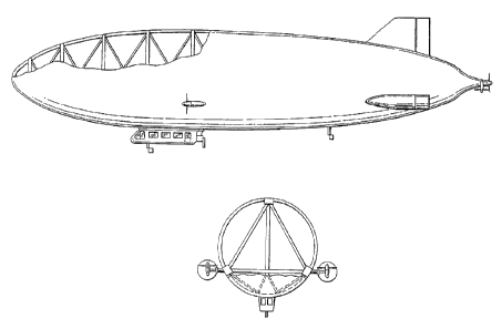
Figure 4 illustrates a side and front view of another example of an airship.
The
triangular rigid structure can be seen within the front view, for example. For
more
information regarding rigid airship designs, the reader is referred to U.S.
Patent No.
13
CA 02617125 2012-02-24
5,285,986, entitled "Rigid Airship with a Carrier Frame of Ribs and Beams
enclosed by
Skin Sections forming an Envelope," as if fully set forth in this description.
Many other designs are possible as
well. The airships illustrated in Figures 3 and 4 are only examples.
To=collect geophysical data using the airship 150, some geophysical
instruments
may be positioned within the gondola 154 and others may be positioned outside
the
gondola, e.g., such as magnetic detectors or a LIDAR unit. For example, an FTG
instrument can be installed within the gondola 154 to collect gravity gradient
data. In
addition, a gradiometer may be mounted directly to the gondola or may be
mounted on a
to stabilized platform to further reduce sensitivity to the airship
motion. Additional frames
or platforms may be added as needed, for example, to spread the weight of the
gradiometer to support a carbon fiber floor of the airship.
The airship can then be flown at low speeds, so as to enable the FTG
instrument
to collect data that has a high resolution over a geographical area. For
example,
Zeppelins are usually flown around 45 knots; however, to collect gravity
gradient data,
the Zeppelin may be flown at about 35 knots or about 17 m/sec. Currently,
geographical
data is collected using aircraft flying at speeds of 60 m/s. Airplanes cannot
fly much
slower at the desired altitudes. Thus, using an airship, data can be collected
by flying
within the range of about 15 to about 55 knots (groundspeed), or within the
range of
about 8 m/s to about 22m/s, and by flying at the lower speeds, higher
resolution data can
be collected. Note that slower speeds enable use of slow speed ducted fans and
14
CA 02617125 2008-01-08
propellers, which possibly results in lower vibration than other forms of
aircraft, and in
turn results in less noise generated enabling a better signal-to-noise ratio
to be achieved.
At the low speeds mentioned above, a value of the airship's vertical
acceleration
about the nominal value of the Earth's gravity can be less than about a 40
millG standard
deviation (depending on the speed of the airship, lower or higher deviations
from the
nominal value of the Earth's gravity can be obtained). Using the airship will
provide a
lower vertical acceleration than using a fixed wing aircraft (for the same
conditions of
turbulent air), for example. The standard deviation is the square root of the
sum of the
measured acceleration samples minus 1 G (i.e., 9.8 --27 ), squared and divided
by the
to number of samples over a specific time period as shown below in Equation
(3). The
standard deviation is expressed in millG or 10 meters/sec2/1000 (1 millG is
1/1000 of the
Earth's gravity).
1
= ¨E ( 2 ¨ 102 Equation (3)
N
Thus, since the airship provides a low turbulent, slow environment from which
signals
are collected, the aircraft's vertical acceleration may not differ
significantly from that of
the Earth's gravity. As a result, geophysical signals can be collected while
flying over
land that would be similar (or close to) the signals that would be collected
if standing on
the land.
In addition, the Zeppelin's normal flying altitude is 1000 feet; however, to
collect
gravity gradient data, the Zeppelin is flown at about 250 feet, or anywhere in
the range of
about 150 feet to about 1000 feet. Contrast with current data collection
altitudes on-
CA 02617125 2008-01-08
board a fixed wing aircraft of about 80 to 120 m (e.g., 260 ¨ 400 feet). A
Zeppelin can
fly at low altitudes using a take-off and landing engine configuration in
which an aft
engine is directed downward instead of rearward for improved height control.
Further, a
third rear engine on the airship provides additional directional control.
Lower flight altitudes result in an improved gravity gradient signal-to-noise
ratio.
For example, gravity gradients are expressed as:
1
a , Equation (4)
r'
where the Tensor component, Tm, (gravity gradient) is inversely proportional
to the cube
of r, which is the distance from the measuring system to the body being
measured. Thus,
since a signal decays as the cube of the distance from the body, flying at
lower altitudes
or closer to the Earth's surface enables higher quality signals to be
retrieved.
Performing gravity gradient surveys at low speeds and low altitudes allows for
high resolution and low noise data (e.g., high signal-to-noise ratio) to be
collected. For
example, more data points per square foot will be collected, such as
collecting one data
point about every 31 meters at a ground speed of about 30 knots as in the
current Air-
FTG system implementation. Gravity gradients are expressed in Etitvos units
(E) to
= measure the rate of change, or gradient in the acceleration of gravity
with horizontal
distance (one Eotvos equals 10-7 Gal per meter), and changes in horizontal
gradients are
typically below 100 E for the normal field. Thus, gravity-gradient anomalies
indicating
mineral or other underground deposits are indicated by small changes in the
normal field,
such as about 10-50 E, for example. Small deposits will not affect the field
as much as
large deposits, and thus will have small effects on the normal field, e.g.,
about a 1 E to
16
CA 02617125 2008-01-08
about a 5 E change. As a result, high resolution data can be very helpful in
locating small
gravity anomalies, and it may even be possible to collect data that indicates
changes in
the gravity field within about 1-5 E by using an airship.
In addition, referring back to Figures 3 and 4, note that the propellers 156
and 158
are not connected to the gondola 154, but rather to the rigid frame of the
airship 150.
Since the FTG gravity gradient instruments are located within the gondola 154,
noise
generated by the engines will not affect the data collection as much as within
typical FTG
data collection using an airplane (e.g., where the FTG instruments are located
within the
same platform as the aircraft engines). For example, the design of the
Zeppelin NT
allows for the engines being further removed from the FTG with reduced
vibration
induced noise, which further enables low noise data signals to be collected.
Furthermore, airships that do not depend upon aerodynamic lift have lower
levels
of turbulence than other aircraft platforms, which results in lower
acceleration induced
noise within a gravity gradient signal. This enables better resolution and
lower noise
levels within signals.
Zeppelins generally also have high maneuverability when compared to non-rigid
frame airships, and combined with low speed and low flight surveys, the
Zeppelin airship
is a desirable platform to use for FTG data collection. The maneuverability of
the
Zeppelin NT, for example, due to the engines positioned on sides of the
airship, causes
the Zeppelin NT to be a desirable airship for FTG data collection. Further, a
Zeppelin
uses control surfaces (e.g., the envelope and fins) like an aircraft, which
may be less
17
CA 02617125 2008-01-08
efficient at slow speeds, and thus a pilot can swivel the forward engines
upwards,
typically by 20 , to improve vertical control for additional maneuverability.
Low flight and low speed gravity surveying also provides additional safety
precautions. For example, many terrain obstacles may be present when
conducting low
flight surveys; however, while also flying at low speeds, the airship can
maneuver about
the terrain more easily. Further, areas that may not be surveyable using an
aircraft can be
surveyed using an airship. For example, planes may not be able to fly close
enough to
areas with steep hills or with varying terrain, whereas an airship may be able
to more
effectively maneuver such terrain.
to
Using an airship to collect gravity gradient data can also allow for longer
data
collection periods. For example, airships have higher fuel efficiency than a
fixed wing
aircraft platform at slow speeds, which results in longer duration and lower
cost gravity
surveys. As one example, an airship may be able to conduct a gravity survey
for a
duration of about 8 hours before refueling.
The design of the Zeppelin NT provides for the third rear mounted engine that
increases control of the airship and enables the airship to substantially stay
on a desired
path. Referring to Figure 5, geophysical data is recorded and associated with
a flight
trajectory that is generally a straight line, and Figure 5 illustrates one
example of a survey
flight pattern. A survey area 170 can be divided in a grid, resulting in seven
rows 172-
184 corresponding to flight paths, for example. The airship may then fly a
straight path
for a certain distance to collect geophysical data along that path.
Subsequently, the
airship can reverse directions to fly a substantially straight path to collect
geophysical
18
CA 02617125 2008-01-08
data from the terrain that is South of the first flight path. Thus, the
airship can fly in a
series of nominally parallel survey lines until the total survey area 170 has
been covered.
In this example, the airship flies from North to South; however, the flight
paths could be
configured in any manner. The maneuverability of the Zeppelin allows for
substantially
straight lines to be flown.
An airship can fly efficiently at lower speeds than a fixed wing aircraft,
which in
turn, results in lower levels and lower frequencies of vertical acceleration
and in a
configuration that results in lower engine noise. Each of these improvements
results in
lower noise contained within measurements and improved resolution than
currently
possible when using fixed wing or rotary wing aircraft for geophysical survey
flights.
It is intended that the foregoing detailed description be regarded as
illustrative rather than
limiting, and it is intended to be understood that thp following claims
including all
equivalents define the scope of the invention.
19