Note: Descriptions are shown in the official language in which they were submitted.
CA 02617745 2011-02-10
PORTABLE ANTENNA POSITIONER APPARATUS AND METHOD
INVENTORS:
SPENCER WEBB
DAVID MARTIN
This application is a continuation in part and claims priority to United
States Utility Patent
Application entitled "Portable Antenna Positioner Apparatus and Method", which
has since
issued on February 6, 2007 as United States Patent No. 7,173,571.
This invention was made with Government support under F19628-03-C-0039 awarded
by US
Air Force, Department of Defense. The Government has certain rights in the
invention.
BACKGROUND OF THE INVENTION
FIELD OF THE INVENTION
[0011 Embodiments of the invention described herein pertain to the field of
antenna positioning
systems. More particularly, but not by way of limitation, these embodiments
enable the
positioning of antennas byway of a compact, lightweight, portable, self-
aligning antenna
positioner that is easily moved by a single user and allows for rapid setup
and alignment.
DESCRIPTION OF THE RELATEDART
[0021 An antenna positioner is an apparatus that allows for an antenna to be
pointed in a desired
direction, such as towards a satellite. Many satellites are placed in
geosynchronous orbit at
approximately 22,300 miles above the surface of the earth. Other satellites
may be placed in low
earth orbit and traverse the sky relatively quickly. Generally, pointing may
be performed by
adjusting the azimuth and elevation or alternatively by rotating the
positioner about the X and Y
axes. Once oriented in the proper direction, the antenna is then best able to
receive a given
satellite signal.
[0031 Existing antenna positioners are heavy structures that are bulky and
require many workers
to manually setup and initially orient. These systems fail to satisfactorily
achieve the
1 of 28
CA 02617745 2008-02-01
WO 2006/116695 PCT/US2006/016282
full spectrum of compact storage, ease of transport and rapid setup. For
example, currently
fielded antenna systems capable of receiving Global Broadcast System
transmissions
comprise an antenna, support, positioner, battery, cables, receiver, decoder
and PC. These
antenna systems require over a half dozen storage containers that each require
2 or more
workers to lift. Other antenna systems are mounted on trucks and are generally
heavy and
not easily shipped.
2
CA 02617745 2008-02-01
WO 2006/116695 PCT/US2006/016282
BRIEF SUMMARY OF THE INVENTION
[004] Embodiments of the invention provide a lightweight, collapsible and
rugged antenna
positioner for use in receiving low earth orbit and geosynchronous satellite
transmissions. By
collapsing the antenna positioner, it may be readily carried by hand or
shipped in a compact
container. For example, embodiments of the invention may be stored in a common
carry-on
bag for an airplane. The antenna positioner may be used in remote locations
with manually
assisted or automated setup and orientation. Embodiments of the invention may
be produced
at low cost for disposable applications. The apparatus can be scaled to any
size by altering
the size of the various components. The gain requirements for receiving any
associated
satellite transmission may be altered by utilizing more sophisticated and
efficient antennas as
the overall size of the system is reduced.
[005] The movement of an antenna coupled with embodiments of the portable
antenna
positioner allows for low earth orbit, geostationary or geosynchronous
location and tracking
of a desired satellite. Since the slew rate requirements are small for
geosynchronous
satellites, the motors used in geosynchronous applications may be small.
[006] One embodiment of the invention may be used, for example, after
extending stabilizer
legs and an adjustable leg to provide a stable base upon which to operate. In
embodiments
with a battery coupled with the apparatus, the antenna is extended and the
system is aligned
near a desired satellite at which time the system searches for and finds a
desired satellite. The
entire setup process can occur in rapid fashion. Another embodiment of the
invention may
utilize alternate mechanical positioning devices such as an arm that extends
upward and
allows for azimuth and elevation motors to adjust the antenna positioning.
Another
embodiment of the invention utilizes a smaller azimuth motor and limited range
in order to
lower the overall weight of the apparatus.
[007] One or more embodiments utilize an adjustable leg or legs that may be
motorized with
for example a stepper motor. These embodiments are able to alter the effective
elevation
angle of a satellite relative to the apparatus so that the satellite is far
enough away from the
zenith to prevent "keyholing".
[008] In one embodiment of the invention, positioning of an associated antenna
is performed
by rotating positioner support frame in relation to a positioner base in order
to set the
3
CA 02617745 2008-02-01
WO 2006/116695 PCT/US2006/016282
azimuth. Setting the elevation is performed by altering the angle of the
antenna mounting
plate with respect to the positioner support frame. Since the elements are
rotationally
coupled to each other, rotation of the positioning arm alters the angle of the
antenna mounting
plate in relation to the positioner support frame. The motion of the antenna
alters the angle of
the antenna with relation to the positioner base. The resulting motion
positions a vector
orthogonal to the antenna mounting plate plane in a desired elevation and with
the positioner
base rotated to a desired azimuth, the desired pointing direction is achieved.
Another
embodiment of the invention makes use of an arm that comprises azimuth and
elevation
motors that are asserted in order to point an antenna to a desired pointing
direction.
[0091 The pointing process is normally accomplished via powered means using
the
mechanisms described above. Various components are utilized by the apparatus
to
accomplish automated alignment with a desired satellite. A GPS receiver is
used in order to
obtain the time and the latitude and longitude of the apparatus. In addition,
a tilt meter
(inclinometer) or three axis accelerometer and magnetometer are be used to
determine
magnetic north and obtain the pointing angle of the antenna. By placing a
group of sensors in
both the electronics housing and antenna housing, differential measurements of
tilt or
magnetic orientation may be used for calibration purposes and this
configuration also
provides a measure of redundancy. For example, if the magnetometer in the
positioner base
fails, the magnetometer coupled with the antenna or in the antenna housing may
be utilized.
Such failure may be the result of an electronics failure or a magnetic anomaly
near the
positioner base. A low noise block down converter (LNB) along with a wave
guide allows
high frequency transmissions to be shifted down in frequency for transmission
on a cable.
One or more embodiments of the invention comprise a built-in receiver that
enables the
apparatus to download ephemeris data and program guides for channels. Motors
and motor
controllers to point the antenna mounting plate in a desired direction are
coupled with at least
one positioning arm in order to provide this functionality. Military Standard
batteries such as
BB-2590/M for example maybe used to drive the motors. Any other battery of the
correct
voltage may also be utilized depending on the application. A keypad may be
used in order to
receive user commands such as Acquire, Stop, Stow and Self-Test. A
microcontroller may
be programmed to accept the keypad commands and send signals to the azimuth,
elevation
and optional adjustable leg motor in order to achieve the desired pointing
direction based on a
satellite orbit calculation based on the time, latitude, longitude,
north/south orientation and
tilt of the apparatus at a given time and the various orbital elements of a
desired satellite.
4
CA 02617745 2008-02-01
WO 2006/116695 PCT/US2006/016282
Optionally, a PC may host the satellite orbit program and user interface and
may optionally
transfer commands and receive data from the apparatus via wired or wireless
communications.
[00101 By way of example an embodiment may weigh less than 20 pounds, comprise
an
associated antenna with 39 dBic gain, LHCP polarization, frequency range of
20.2 to 21.2
GHz and fit in an airplane roll-on bag of 14 x 22 x 9 inches. Embodiments of
the invention
may be set up in a few minutes or less and are autonomous after initial setup,
including after
loss and subsequent restoration of power. Although this example embodiment has
a limited
frequency range, any type of antenna may be coupled to the apparatus to
receive any of a
number of transmissions from at least the following satellite systems.
User Frequency Polarization Tracking
1. GBS User 11GHz Rx LP GeoSynch NSK
20.2GHz Rx LHCP Self Aligning
2. GBS + Milstar (1) Plus RHCP GeoSynch NSK
20.2GHz Rx RHCP Self Aligning
44GHz Tx
3. Weather Only 1.7MHz LP LEO Tracking
2.2-2.3MHz RHCP 91 Retrograde
Up to 15 /Sec
4. GBS + Weather (1) Plus (3)
5. Weather or DSP Low 1.7MHz LP GeoSynch
Rate Downlink (LRD) 2.2-2.3MHz RHCP Point and Forget
Weather NPOESS High (5) Plus Polar LEO
Rate Downlink (HRD) 8Ghz RHCP Tracking for 8
GHz
6. Wideband Gap Filler 7.9-8.4GHz RHCP GeoSynch NSK
(WGS) SHF Low Tx LHCP Self-Aligning
7.25-7.75GHz
Rx
7. WGS EHF High 30GHz Tx RHCP GeoSynch NSK
20GHz Rx RHCP Self-Aligning
CA 02617745 2008-02-01
WO 2006/116695 PCT/US2006/016282
[0011] Any other geosynchronous or low earth orbiting satellite maybe received
by coupling
an appropriate antenna to the apparatus. For example, a dish or patch array
antenna may be
coupled to the antenna mounting plate. An example calculation of the size of
dish or patch
array to achieve desired gains follows. An ideal one-meter dish, at 20 GHz,
has a gain of
46.4 dBi. With 68% efficiency, it would have a gain of 44.7 dBi. A one-half
meter diameter
dish, therefore, would be 6 dB less, for again of 38.7 dBi. Certain patch
arrays have
efficiencies on the order of 30%, or about 3.6 dB below a dish of similar
area. A patch array
with a gain of 39dBi would have an area of 0.474 square meters. A dish with a
gain of 39
dBi would have an area of 0.209 square meters, or a diameter of 0.516 meters.
For a patch
array consisting of four panels, this implies each panel should have an area
of 0.119 square
meters, or 184 square inches. This is a square with sides of 13.6 inches. A
panel that
measures 20in. by 12in. has an area of 240 square inches (0.155 square
meters). For the 4-
panel system, the area is 960 square inches or 0.619 square meters; with a
calculated gain of
40.2 dBi. Embodiments of the invention are readily combined with these example
antennas
and any other type of antennas. Optionally a box horn antenna may be coupled
with the
apparatus that is smaller and more efficient than a patch array antenna, but
that is generally
heavier and thicker. Additionally a wave guide fed slot array may be utilized.
[0012] Position Sensors used in embodiments of the invention allow for mobile
applications.
One or more accelerometer and/or gyroscope may be used to measure
perturbations to the
pointing direction and automatically adjust for associated vehicle movements
in order to keep
the antenna pointed in a given direction.
[0013] Some example components that may be used in embodiments of the
invention include
the Garmin GPS 15H-W, 010-00240-01, the Microstrain 3DM-G, the Norsat LNB
9000C the
EADmotors L1SZA-H11XA080 and AMS motor driver controllers DCB-241. These
components are exemplary and non-limiting in that substitute components with
acceptable
parameters may be substituted in embodiments of the invention.
[0014] In addition, one or more embodiments of the invention may comprise mass
storage
devices including hard drives or flash drives in order to record programs or
channels at
particular times. The apparatus may also comprise the ability to transmit
data, and transmit at
preset times. Use of solar chargers or multiple input cables allows for
multiple batteries or
the switching of batteries to take place. The apparatus may search for
.satellites in any band
6
CA 02617745 2008-02-01
WO 2006/116695 PCT/US2006/016282
and create a map of satellites found in order to determine or improve the
calculated pointing
direction to a desired satellite. The apparatus may also comprise stackable
modules that
allow for cryptographic, routing, power supplies or additional batteries to be
added to the
system. Such modules may comprise a common interface on the top or bottom of
them so
that one or more module may be stacked one on top of another to provide
additional
functionality. For lightweight deployments all external stackable modules
including the legs
may be removed depending on the mission requirements.
[0015] Low power embodiments of the invention employ a limited range of motion
in
azimuth for the antenna positioner which allows the operator to be presented
with an "X" in a
box of the user interface. The operator sets the system to point within 60
degrees of a
satellite, not 360 degrees. The system then prompts the user with the "X"
which is on the left
of the box if the operator should rotate the positioner base to the left and
the "X" appears on
the right side of the box if the operator is to rotate the positioner base to
the right. Once the
positioner base is within 30 degrees, the operator asserts a button and the
system begins to
acquire a satellite.
[0016] The system may employ tilt compensation so that even if the positioner
base is not
level, the scan includes adjustment to the elevation motor so that the scan
lines are parallel to
the horizon not to the incline on which the positioner base is situated. The
three-axis
accelerometer is used to provide tilt measurements in one or more embodiments
of the
invention.
[0017] The search algorithm utilized by the system may be optimized to search
in azimuth
and sparsely search in elevation. This is due to the fact that magnetic
anomalies are more
prevalent than gravitational anomalies. The system looks first in azimuth
before elevation
(preferential azimuth searching) since that is where the errors are likely
found. For example
in one embodiment, the search proceeds to do two horizontal scan lines first
above the initial
point before performing two horizontal scan lines below the initial point. In
other words, after
the signal peaks, it goes to peak then leaves the raster scan algorithm then
uses a box peaking
algorithm right and up to a corner, go to a left corner, down to corner and
right bottom
corner, e.g., 5 measurements. Then the system points to the strongest and does
the four
corner measurements again. When the four corners of the box have equal
strength the
antenna is positioned correctly and the search algorithm terminates.
7
CA 02617745 2008-02-01
WO 2006/116695 PCT/US2006/016282
[0018] The system also is capable of manually-assisted linear polarization
setting. When
aligning the third axis, that is aligning the antenna about an axis orthogonal
to the antenna
plane for linear polarization, the operator may be prompted for rotating the
antenna manually.
This allows for the elimination of a third motor although this motor is
optional and may be
employed in embodiments that are not power sensitive. The linear polarization
axis is the
least critical of all of the axial settings, so a little error is acceptable.
In addition, the system
without a linear polarization axis motor is lower weight.
[0019] The system may also be configured for bump detection and reacquisition.
In this
configuration, the system detects when the base or the antenna is bumped and
reacquires the
satellite. If the satellite signal is still high, then the system returns to a
four corner boxing
algorithm for example, otherwise the system goes back into scan mode. With two
three-axis
accelerometers, one on positioner base and one on antenna, both may be used
for bump
detection.
[0020] In order to further save power and time in acquiring satellites, the
age of the two line
element (TLEs) is taken into account in one or more embodiments of the
invention. This is
known as Clarke Belt Fallback. For ephemeris data or two line elements, fresh
TLE data
allows the system to point to the satellite accurately. However, in a couple
of weeks, the TLE
information is out of date, in a couple of months is actually quite
inaccurate. For perfectly
stationary satellites on the Clarke belt, i.e.,. equator, all the system has
to know is the
longitude to find one of these satellites. The satellites that move have a
problem in that a
fresh TLE is more accurate than a Clarke Belt longitude, but after 30 days the
system falls
back to the Clarke Belt longitude since it is more accurate after about this
time span. Without
fresh TLEs, acquisition takes more time and power, but by using the Clarke
Belt Fallback, the
system can still function.
[0021] In another power saving embodiment, the tracking of the satellites may
switch
between transponder signal and the beacon tracking signal output by a
satellite. Beacons
have a different frequency and are lower power than the data signal of the
satellite. The
beacons are also omni-directional so the system can find the satellite even if
it is not pointed
at the system at the time of acquisition. For small low power antennas, the
beacon may be
8
CA 02617745 2008-02-01
WO 2006/116695 PCT/US2006/016282
too small to detect, so if the data signal via the satellite transponder is
on, it can be used to
find and lock onto the satellite even if the beacon is too weak to detect.
[0022] Embodiments of the positioner base may make use of a hole in the base
such that
water and other environmental elements do not collect in the positioner base
where the
antenna positioning elements are stored. In this embodiment, a thermal well
may be
employed wherein all of the heat-making components situated in the positioner
base, i.e., the
electronics utilized by the system, dissipate heat. With regards to saving
power and
minimizing heat dissipation, algorithms that conserve power may be utilized in
one or more
embodiments of the invention. For example, when tracking a geosynchronous
satellite, e.g.,
one that move in a figure eight pattern but remains relatively in one general
area of the sky,
the system can stop tracking the satellite at the top and bottom of the figure
eight since
motion is relatively slow there. The system can switch to more rapid tracking
when the
satellite is scheduled to move from the upper to the lower portion of the
figure eight since the'
satellite motion is fast during this period. Conserving power as determined by
two-line
element (TLE) determined re-peak schedule allows for lower power dissipation
and longer
battery life. The system may utilize distributed 12C thermal sensors. The
sensors may be
placed on the electronics boards utilized by the system for example, so the
computer can self-
monitor the components.
[0023] The system allows for updating TLEs over the data link acquired. This
allows for
fresh TLEs to be used in locating and tracking satellites. The broadcasters
may be configured
to send down TLEs that the system uses to automatically update the local TLEs.
After one
month, the TLEs are considered old and if the system is powered up, then it
may
automatically update the TLEs if the acquired satellite is configured to
broadcast them.
[0024] Some embodiments of the invention allow for a quick disconnect for the
antenna
panel. This allows for different satellites having entirely different
frequency bands to be
acquired with the system. This quick disconnect capability may be implemented
by using
double pins to hook the antenna to positioning arm. By releasing one antenna
and attaching
another antenna to the positioning arm, a different set of satellites in
general may be acquired
since satellites use various frequencies. Linearly polarized satellites,
generally commercial
satellites, may be acquired using a third rotational motor that allows for the
antenna to rotate
about the axis pointing at a satellite. For low power configurations, this
allows for the user to
9
CA 02617745 2008-02-01
WO 2006/116695 PCT/US2006/016282
be prompted to rotate the antenna until the strength of the signal is
maximized. Low power
embodiments therefore do not require a third axis motor.
[0025] One ore more embodiments of the invention provide an Integrated
Receiver Decoder
(IRD) slot. An IRD allows for set-top box functionality and may provide
channel guide type
functionality. The user interface to the IRD may include an IRD lock function
that allows for
feedback to the user for tracking qualification. If the IRD is integrated into
the positioner
base, the IRD can provide input to the positioner's computer or a visual
display to the user to
qualify the satellite as being identified as the desired satellite. In one
small area of the sky,
there maybe five 5 commercial satellites in the field of view, so the system
may prompt the
user to select Next Satellite to continue looking for the correct satellite or
the computer may
automatically look to the next satellite.
[0026] Embodiments may utilize a "one button" or "no button" setup procedure.
After
opening the system and deploying the antenna and turning the power on, the
system
determines where it is and if pointed within a general direction of a
satellite, requires no
button pushes for the system to lock. The system can also perform the no
button option so
that after power loss and restore, the system re-acquires a satellite. This
may occur with no
intervention. One button operation may be utilized when the system is not
rotated close
enough to a satellite for example, where the system may prompt the user to
rotate the base in
one direction or the other and assert the acquire button. The prompt may
include an "X" to
the left or right in the LED screen to let the user know to turn the base
clockwise or
counterclockwise for example. The user interface may also present auto
satellite options.
For example, the first choice and second choice satellites maybe presented to
the user based
on the band the system is configured for. Based on the location of the antenna
on the planet,
the user interface shows the operator the most likely satellite that is
normally picked.
[0027] The system may also employ a failure contingency tree. For example if
any portion
of the system fails, the system may prompt the user via the display and allow
the user to
utilize the keyboard to respond to system requests for positioning the system,
etc. For
example, if the GPS or tilt fails, the system allows the operator to
compensate for the error,
prompts for entry on keyboard, of the GPS position or to acknowledge that the
base is level.
In short, the system is configured to ask the user for help if components
break.
CA 02617745 2008-02-01
WO 2006/116695 PCT/US2006/016282
[0028] One or more embodiments of the invention allow for a sensor built into
changeable
antenna. For example, a 3 positioner accelerometer may be built into the
changeable antenna
panel. In addition, the antenna panel may be configured with memory in the
changeable
antenna that is used to notify the system what band the antenna is, so the
system does not
have to perform third axis rotation when not acquiring a satellite that uses
linear polarization.
For example, if acquiring a Ka band military satellite, the antenna panel is
read and based on
the fact that the Ka band antenna is being utilized, a whole set of the
correct satellites in the
correct band may be presented to the user via the user interface wherein some
of all of the
previous satellites receivable with the previous antenna are no longer
presented. An
additional tilt sensor may be utilized in the positioner base for
crosschecking with antenna.
Any redundant positioners may be placed throughout the system in order to
provide
redundancy and crosschecking capabilities.
[0029] The system has no loose parts and requires no tools. Since there are no
parts to loose,
the system is more robust. The system may include a camouflage bag that
encapsulates the
system and may be changed from desert to jungle to urban camouflage or black.
Many
different types of legs may be employed on the system depending on the terrain
that the
system is to be used in, including but not limited to legs with rubber
bottoms, spikes or any
other type of bottom, and the legs themselves may be of any type including
telescoping or
rigid or any other type.
11
CA 02617745 2008-02-01
WO 2006/116695 PCT/US2006/016282
BRIEF DESCRIPTION OF THE DRAWINGS
[0030] Figure 1 shows a flowchart depicting the manufacture of one or more
embodiments
of the invention.
[0031] Figure 2 shows an embodiment of the position base configured with a
hole to allow
for environmental elements to escape and to also manage heat dissipation of
the system.
[0032] Figure 3 shows a close-up of Figure 2.
[0033] Figure 4 shows a cross sectional view of Figure 2.
[0034] Figure 5 shows an isometric view of an embodiment of the invention with
the antenna
housing at a second azimuth and elevation setting.
[0035] Figure 6 shows an isometric view of an embodiment of the invention in
the stowed
position.
[0036] Figure 7 shows an isometric view of the bottom of an embodiment of the
invention in
the stowed position.
[0037] Figure 8 shows an isometric view of an embodiment of the invention in
the deployed
position.
[0038] Figure 9 shows an isometric view of an embodiment of the invention with
the antenna
housing at a first azimuth and elevation setting.
12
CA 02617745 2008-02-01
WO 2006/116695 PCT/US2006/016282
DETAILED DESCRIPTION OF THE INVENTION
[0039] Embodiments of the invention provide a self contained lightweight,
collapsible and
rugged antenna positioner for use in receiving and transmitting to low earth
orbit,
geosynchronous and geostationary satellites. In the following exemplary
description
numerous specific details are set forth in order to provide a more thorough
understanding of
embodiments of the invention. It will be apparent, however, to an artisan of
ordinary skill
that the present invention may be practiced without incorporating all aspects
of the specific
details described herein. Any mathematical references made herein are
approximations that
can in some instances be varied to any degree that enables the invention to
accomplish the
function for which it is designed. In other instances, specific features,
quantities, or
measurements well-known to those of ordinary skill in the art have not been
described in
detail so as not to obscure the invention. Readers should note that although
examples of the
invention are set forth herein, the claims, and the full scope of any
equivalents, are what
define the metes and bounds of the invention.
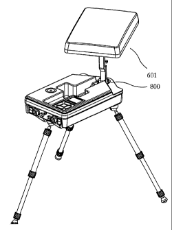
[0040] Figure 6 shows an isometric view of an embodiment of the invention in
the stowed
position. Positioner base 600 houses electronic components and mates with
antenna housing
601 for compact storage. Positioner base 600 provides access to power switch
602, remote
computer Ethernet connector 604, power plug A 606, power plug B 607, LNB RF
out 608,
data Ethernet connector 605 and day/night/test switch 603. Power plug A 606
and power
plug B 607 are utilized for coupling with power sources, batteries and solar
panels for
embodiments without built in receivers. Data Ethernet connector 605 provides
internal
receiver data for embodiments comprising at least one built in receiver which
allows for
coupling with external network devices capable of consuming a satellite data
stream. In
addition, one or more embodiments of the invention may use data Ethernet
connector 605 for
providing the apparatus with transmission data for transmission to a desired
satellite.
Day/night/test switch 603 is utilized in order to set the display (shown in
Figs. 8-10) to
provide for day and night time visual needs while the third position is
utilized in order to test
the system without deploying antenna housing 601.
[0041] Figure 7 shows an isometric view of the bottom of an embodiment of the
invention in
the stowed position. Carrying handle 703 may be used to physically move the
apparatus.
Legs 700, 701 and 702 may form a removable leg system as shown or may
independently be
mounted to the bottom of positioner base 600. In addition, a stackable module
maybe
13
CA 02617745 2008-02-01
WO 2006/116695 PCT/US2006/016282
coupled to positioner base 600 in order to provide cryptographic,
power/battery, router or any
other functionality to augment the capabilities of the apparatus.
[0042] Figure 8 shows an isometric view of an embodiment of the invention in
the deployed
position. Legs 700 and 701 are shown in the deployed position. Bubble level
806 is used to
level positioner base 600 in combination with the legs or by placing objects
underneath an
embodiment of the invention not comprising legs until positioner base 600 is
roughly level.
The system has no loose parts and requires no tools. Since there are no parts
to loose, the
system is more robust. The system may include a camouflage bag that
encapsulates the
system and may be changed ,from desert to jungle to urban camouflage or black.
Many
different types of legs may be employed on the system depending on the terrain
that the
system is to be used in, including but not limited to legs with rubber
bottoms, spikes or any
other type of bottom, and the legs themselves may be of any type including
telescoping or
rigid or any other type. Keypad 804 and display 805 are utilized in order to
control the
apparatus. Also shown is azimuth motor 800 that rotates positioning arm 801
and elevation
motor 802 which rotates antenna housing 601 in elevation. In one or more
embodiments,
antenna housing 601 may be rotated on an axis orthogonal to the plane of
antenna housing
601 and may optionally include a third motor, however low power embodiments of
the
invention allow for the operator of the system to manually rotate antenna
housing 601 for
linear polarized satellite signals. LNB 803 couples with the reverse side of
the antenna that is
located within antenna housing 601. When opening one embodiment of the
invention,
positioning arm 801 locks into a vertical position as shown and after
selecting a satellite to
acquire an internal or external microcontroller rotates azimuth motor 800 and
elevation motor
802 based on the GPS position, time and compass orientation of the apparatus.
One
embodiment of the invention may provide a limited turning range for azimuth
motor 800 for
example 60 degrees, in order to limit the overall weight of the device by
allowing for simpler
cable routing and minimizing complexity of the mechanism. Positioner base 600
comprises
an indentation shown in the middle of positioner base 600 for housing
positioning arm 801,
elevation motor 802 and LNB 803 when in the stowed position. The indentation
may make
use of a hole that allows for environmental elements such as water, dirt, mud,
snow or any
other objects to drain or fall through the indentation. In addition, the hole
may be coupled to
the electronic components in order to provide a thermal well for heat
management purposes.
(See Figure 2). In one or more embodiments, thermal bonding of the electronic
components
to the upper and lower portions of the positioner base does not comprise a
hole. Electronic
14
CA 02617745 2008-02-01
WO 2006/116695 PCT/US2006/016282
components internal to positioner base 600 may comprise a microcontroller or
computer
which hosts a control program which reads inputs from keypad 804 and commands
azimuth
motor 800 to rotate to a desired azimuth. Positioner base 600 may also
comprise a GPS
receiver that provides time and position information to the microcontroller.
Positioner base
600 and antenna housing 601 may comprise a three axis accelerometer or
inclinometer,
magnetometer, data receiver and relative signal strength indicator (RSSI)
receiver and reports
to the microcomputer the signal strength of the signal received and that
information is used
for the accurate pointing of the antenna.
[0043] Using keypad 804, embodiments of the invention may utilize a "one
button" or "no
button setup" procedure. After opening the system and deploying the antenna in
antenna
housing 601 and turning the power on, the system determines where it is and if
pointed
within a general direction of a satellite, requires no button pushes for the
system to lock. The
system can also perform the no button option so that after power loss and
restore, the system
re-acquires a satellite. This may occur with no intervention. One button
operation may be
utilized when the system is not rotated close enough to a satellite for
example, where the
system may prompt the user to rotate positioner base 600 in one direction or
the other and
assert the acquire button. The prompt may include an "X" to the left or right
in display 805
(for example an LED screen) to let the user know to turn positioner base 600
clockwise or
counterclockwise for example. Display 600 may also present auto satellite
options. For
example, the first choice and second choice satellites may be presented to the
user based on
the band the system is configured for. Based on the location of the antenna on
the planet, the
user interface shows the operator the most likely satellite that is normally
picked.
[0044] With regards to saving power and minimizing heat dissipation,
algorithms may be
employed by the computer housed in positioner base 600, that conserve power
may be
utilized in one or more embodiments of the invention.
[0045] Low power embodiments of the invention employ a limited range of motion
in
azimuth (e.g., azimuth motor 800 rotates only a portion of 360 degrees) for
the antenna
positioner which allows the operator to be presented'with an "X" in a box of
the user
interface is display 805. The operator sets the system to point within 60
degrees of a satellite,
not 360 degrees. The system then prompts the user with the "X" which is on the
left of the
box if the operator should rotate the positioner base to the left and the "X"
appears on the
CA 02617745 2008-02-01
WO 2006/116695 PCT/US2006/016282
right side of the box if the operator is to rotate the positioner base to the
right. Once the
positioner base is within 30 degrees, the operator asserts a button and the
system begins to
acquire a satellite. Wiring of the system is simplified by sub-360 degree
rotation and weight
is lowered as well.
[0046] The search algorithm utilized by the system may be optimized to search
in azimuth
and sparsely search in elevation. This is due to the fact that magnetic
anomalies are more
prevalent than gravitational anomalies. The system looks first in azimuth
before elevation
(preferential azimuth searching) since that is where the errors are likely
found. For example
in one embodiment, the search proceeds to do two horizontal scan lines first
above the initial
point before performing two horizontal scan lines below the initial point. In
other words, after
the signal peaks, it goes to peak then leaves the raster scan algorithm then
uses a box peaking
algorithm right and up to a corner, go to a left corner, down to corner and
right bottom
corner, e.g., 5 measurements. Then the system points to the strongest and does
the four
corner measurements again. When the four corners of the box have equal
strength the
antenna is positioned correctly and the search algorithm terminates.
[0047] In order to further save power, one or more embodiment may allow for
the computer
to perform tracking at uneven time intervals. For example, when tracking a
geosynchronous
satellite, e.g., one that move in a figure eight pattern but remains
relatively in one general
area of the sky, the system can stop tracking the satellite at the top and
bottom of the figure
eight since motion is relatively slow there. The system can switch to more
rapid tracking
when the satellite is scheduled to move from the upper to the lower portion of
the figure eight
since the satellite motion is fast during this period. Conserving power as
determined by two-
line element (TLE) determined re-peak schedule allows for lower power
dissipation and
longer battery life. The system may utilize distributed I2C thermal sensors.
The sensors may
be placed on the electronics boards utilized by the system for example, so the
computer can
self-monitor the components.
[0048] In another power saving embodiment, the computer housed in positioner
base 600
performs tracking of the satellites in a manner that may switch between
transponder signal
and the beacon tracking signal output by a satellite. For example, beacons
have a different
frequency and are lower power than the data signal of the satellite. The
beacons are also
omni-directional so the system can find the satellite even if it is not
pointed at the system at
16
CA 02617745 2008-02-01
WO 2006/116695 PCT/US2006/016282
the time of acquisition. For small low power antennas, the beacon may be to
small to detect,
so if the data signal via the satellite transponder is on, it can be used to
find and lock onto the
satellite even if the beacon is too weak to detect.
[0049] In order to further save power and time in acquiring satellites, the
age of the two line
(TLEs) is taken into account in one or more embodiments of the invention by
the computer
housed in positioner base 600. This is known as Clarke Belt Fallback. For
ephemeris data or
two line elements (TLEs as used by Nasa), fresh TLE data allows the system to
point to the
satellite accurately. However, in a couple of weeks, the TLE information is
out of date, in a
couple of months is actually quite inaccurate. For perfectly stationary
satellites on the Clarke
belt, i.e., equator, all the system has to know is the longitude to find one
of these satellites.
The satellites that move have a problem in that a fresh TLE is more accurate
than a Clarke
Belt longitude, but after 30 days the system falls back to the Clarke Belt
longitude since it is
more accurate after about this time span. Without fresh TLEs, acquisition
takes more time
and power, but by using the Clarke Belt Fallback, the system can still
function.
[0050] Figure 9 shows an isometric view of an embodiment of the invention with
the
antenna housing at a first azimuth and elevation setting. Antenna housing 601
in this figure
is pointed at a satellite midway between the zenith and horizon. Figure 5
shows an isometric
view of an embodiment of the invention with the antenna housing at a second
azimuth and
elevation setting wherein the satellite is directly above the apparatus at the
zenith. One or
more embodiments of the control program may search for a desired satellite by
scanning
along the azimuth as the elevation of the apparatus is generally fairly
accurate and wherein
the local magnetometer may give readings that are subject to magnetic sources
that influence
the magnetic field local to the apparatus.
[0051] Some embodiments of the invention allow for a quick disconnect for the
antenna
panel or antenna itself in antenna housing 601. This allows for different
satellites having
entirely different frequency bands to be acquired with the system. This quick
disconnect
capability may be implemented by using double pins to hook the antenna or
antenna housing
601 to positioning arm 801. By releasing one antenna and attaching another
antenna to the
positioning arm, a different set of satellites in general may be acquired
since some satellites
use various frequencies. Linearly polarized satellites, generally commercial
satellites may be
acquired using a third rotational motor that allows for the antenna to rotate
about the axis
17
CA 02617745 2008-02-01
WO 2006/116695 PCT/US2006/016282
pointing at a satellite. For low power configurations, this allows for the
user to be prompted
to rotate the antenna until the strength of the signal is maximized. Low power
embodiments
therefore do not require a third axis motor.
[0052] The system may also employ a failure contingency tree that is utilized
by the
computer housed in positioner base 600. For example if any portion of the
system fails, the
system may prompt the user via the display and allow the user to utilize the
keypad 804 an
attached keyboard to respond to system requests for positioning the system,
etc. For
example, if the GPS or tilt fails, the system allows the operator to
compensate for the error,
prompts for entry on keyboard, of the GPS position or to acknowledge that the
base is level.
In short, the system is configured to ask the user for help is components
break.
[0053] The system may employ tilt compensation via the computer housed in
positioner base
600 so that even if positioner base 600 is not level, the scan includes
adjustment to elevation
motor 802 so that the scan lines are parallel to the horizon as azimuth motor
800 turns so that
the scan lines are not parallel to the incline on which the positioner base is
situated. The
three-axis accelerometer is used to provide tilt measurements in one or more
embodiments of
the invention.
[0054] The system also is capable of manually-assisted linear polarization
setting. When
aligning the third axis, that is aligning the antenna in antenna housing 601
about an axis
orthogonal to the antenna plane for linear polarization, the operator may be
prompted for
rotating the antenna manually via display 805. This allows for the elimination
of a third
motor although this motor is optional and maybe employed in embodiments that
are not
power sensitive. The linear polarization axis is the least critical of all of
the axial settings, so
a little error is acceptable. In addition, the system without a linear
polarization axis motor is
lower weight. An embodiment using a third axis motor for linear polarization
may be
manually moved if the motor controller for the linear polarization axis is
detected as not
working.
[0055] The system may also be configured for bump detection and reacquisition
via the
computer housed in positioner base 600. In this configuration, the system
detects when the
base or the antenna is bumped and reacquires the satellite. If the satellite
signal is still high,
then the system returns to a four corner boxing algorithm for example,
otherwise the system
18
CA 02617745 2008-02-01
WO 2006/116695 PCT/US2006/016282
goes back into half-scan mode where only half the elevation scan lines are
checked while
checking range of azimuth. With two three-axis accelerometers, one on
positioner base 600
and one in antenna housing 601 or coupled with the antenna in antenna housing
601, both
may be used for bump detection.
[0056] One or more embodiments of the invention allow for a sensor built into
changeable
antenna or changeable antenna housing 601. For example, a three-axis
accelerometer may be
built into the changeable antenna or changeable antenna housing 601. In
addition, the
antenna/housing may be configured with memory in the changeable antenna that
is used to
notify the system what band the antenna is, so the system does not have to
perform third axis
rotation when not acquiring a satellite that uses linear polarization. For
example, if acquiring
a Ka band military satellite, the antenna panel is read and based on the fact
that the Ka band
antenna is being utilized, a whole set of the correct satellites in the
correct band may be
presented to the user via display 805 wherein some of all of the previous
satellites receivable
with the previous antenna are no longer presented. An additional tilt sensor
may be utilized
in the positioner base for crosschecking with antenna. Any redundant
positioners may be
placed throughout the system in order to provide redundancy and crosschecking
capabilities.
[0057] The system allows for updating TLEs over the data link acquired. This
allows for
fresh TLEs to be used in locating and tracking satellites. The broadcasters
may be configured
to send down TLEs that the system uses to automatically update the local TLEs.
After one
month, the TLEs are considered old and if the system is powered up, then it
may
automatically update the TLEs if the acquired satellite is configured to
broadcast them. The
download of ephemeris data or TLEs may occur before or after two months, or at
any time
that is convenient as determined by computer house in positioner base 600 or
by the operator
of the system for example.
[0058] One ore more embodiments of the invention provide an Integrated
Receiver Decoder
(IRD) slot in positioner base 600. An IRD allows for set-top box functionality
and may
provide channel guide type functionality. The user interface to the IRD may
include an IRD
lock function that allows for feedback to the user for tracking qualification.
If the IRD is
integrated into the positioner base, the IRD can provide input to the
positioner's computer or
a visual display to the user to qualify the satellite as being identified as
the desired satellite.
In one small area of the sky, there may be five 5 commercial satellites in the
field of view, so
19
CA 02617745 2008-02-01
WO 2006/116695 PCT/US2006/016282
the system may prompt the user to select Next Satellite to continue looking
for the correct
satellite via display 805 or the computer may automatically look to the next
satellite.
[0059] After physically deploying the apparatus, keypad 804 as shown in Figure
8 may be
utilized in order to operate the apparatus. Operations accessible from keypad
804 comprise
acquire, stop, stow and test and may also include functions for receiving meta
data regarding
a channel for example a program information such as an electronic program
guide for a
channel or multiple channels. Data received by the apparatus may comprise
weather data,
data files, real-time video feeds or any other type of data. Data may also
include TLEs so
that the position information of the satellites is updated. Data may be
received on command
or programmed for receipt at a later time based on the program information
metadata.
Keypad 804 may also comprise buttons or functions that are accessed via
buttons or other
elements for recording a particular channel, for controlling a transmission,
for updating
ephemeris or TLE data or for password entry, for searching utilizing an
azimuth scan or for
searching for any satellite within an area to better locate a desired
satellite. Any other control
function that maybe activated via keypad 804 may be executed by an onboard or
external
computer in order to control or receive or send data via the apparatus.
[0060] Asserting the acquire button and selecting a satellite initiates an
orbital calculation
that determines the location of a satellite for the time acquired via the GPS
receiver. With the
latitude and longitude acquired via GPS receiver and the direction North and
tilt of the
apparatus measured via tilt sensor and magnetometer all of the parameters
required to point
the antenna towards a desired satellite are achieved. Antenna housing 601 is
rotated to the
desired azimuth via azimuth motor 800. The antenna in antenna housing 601 is
elevated to
the desired elevation via elevation motor 802. The internal RSSI receiver may
also be used
in order to optimize the direction that the antenna is pointing to maximize
the signal strength.
[0061] Asserting the stop button on keypad 804 stops whatever task the
apparatus is
currently performing. This button can be activated prior to activating the
stow button. The
stow button realigns positioner arm 801 with positioner base 600 and performs
a system
shutdown. The test button performs internal system tests and may be activated
with or
without antenna housing 601 deployed. These operations maybe modified in
certain
embodiments or performed remotely by an attached PC or over a wireless network
in other
embodiments.
CA 02617745 2008-02-01
WO 2006/116695 PCT/US2006/016282
[0062] Figure 1 shows a flowchart depicting the manufacture of one or more
embodiments
of the invention which starts at 1100 and comprises coupling an antenna with
an elevation
motor at 1101. Optionally a cover or antenna housing may be coupled with the
antenna (not
shown in Figure 1 for ease of illustration). At least one positioning arm is
then coupled with
the elevation motor at 1102. The positioning arm is further coupled with an
azimuth motor at
1103. The azimuth motor is then coupled with a positioner base at 1104. The
computer is
coupled with the positioner base at 1104a. The computer is configured for
searching,
tracking, bump detection and other functionality when coupled to positioner
base, or before
or after coupling with positioner base. The positioner base may comprise a
hole for allowing
environmental elements to fall or leak through the potential well created by
the indentation in
the base that houses the positioner arm when the antenna housing is closed
against the
positioner base. The positioner base may optionally comprise a configuration
that limits the
amount of azimuth travel in order to allow for a smaller or more compact
azimuth motor and
to cut total weight from the system. The apparatus is delivered to an
individual in a
configuration that allows for a single person to carry the apparatus at 1105
wherein the
manufacture is complete at 1106.
[0063] Figure 2 shows an embodiment of the position base configured with a
hole to allow
for environmental elements to escape and to also manage heat dissipation of
the system. The
thermally conductive elements do not require use of a hole and the hole is
optional in one or
more embodiments of the invention. Embodiments of the positioner base may make
use of a
hole in the base such that water and other environmental elements do not
collect in the
potential well in the positioner base where the antenna positioning elements
are stored. In
this embodiment, a thermal well may be employed wherein all of the heat-making
components situated in the positioner base, i.e., the electronics utilized by
the system,
dissipate heat. Thermal well 2001 is shown in the middle of the positioner
base. (In this
embodiment thermal well 2001 also includes a hole in the middle of it to allow
environmental
elements to pass through it. Figure 3 shows a close-up of thermal well 2001
(the optional
hole can be seen in the middle of thermal well 2001). Figure 4 shows a cross
section of
thermal well 2001. When seen from the cross section it becomes clear that
thermal well 2001
is actually male thermal conductor 2001 which couples with upper positioner
base portion
2010 and prevents environmental contamination via O-rings 2003a and 2003b.
Female
thermal conductor 2002 couples to positioner base bottom 2011. Ring 2013
couples to
21
CA 02617745 2008-02-01
WO 2006/116695 PCT/US2006/016282
ground plane 2014 of electronic circuit board 2012. Ground plane 2013 is
generally highly
conductive both thermally and electrically. The hole in male thermal conductor
2001 is
optional. Heat dissipates through the composite positioner base upper and
bottom portions
and allows for the internal components to remain as cool as possible.
[0064] Thus embodiments of the invention directed to a Portable Antenna
Positioner
Apparatus and Method have been exemplified to one of ordinary skill in the
art. The claims,
however, and the full scope of any equivalents are what define the metes and
bounds of the
invention.
22