Note: Descriptions are shown in the official language in which they were submitted.
CA 02620870 2014-05-14
HIGH ACCURACY SURVEY-GRADE GIS SYSTEM
BACKGROUND
[002] A high accuracy survey-grade geographic information system (GIS)
would need to transform distinct isolated land surveys, which could be
separated by
several miles, onto a common coordinate system that does not distort or scale
the
dimensions of those surveys. Furthermore, a high accuracy survey-grade GIS
would have
to position the transformed surveys relative to each other at the same
distances that would
be measured between them on the ground using transit and tape or electronic
distance
measure (EDM). Because the purpose of a high accuracy survey-grade GIS is to
transform
separate isolated surveys onto a common coordinate system in such a manner as
to
produce in essence one unified survey, in order to be survey-grade the
relative positions of
the transformed surveys would have to meet the relative positional accuracy
standards for
ALTA/ACSM land title surveys. Those standards state: "'Relative
Positional Accuracy' means the value expressed in feet or meters that
represents the
uncertainty due to random errors in measurements in the location of any point
on a survey
1
CA 02620870 2008-02-22
WO 2007/024892
PCT/US2006/032835
relative to any other point on the same survey at the 95 percent confidence
level. . = . [The]
Allowable Relative Positional Accuracy for Measurements Controlling Land
Boundaries
on ALTA/ACSM Land Title Surveys [is] 0.07 feet (or 20 mm) +50 ppm."
[003] Global Navigation Satellite Systems (GNSS), such as the United States
Department of Defense's Global Navigation System (GPS), afford land surveyors
the
prospect of relating all their surveys to a common spatial reference system
based on
geodetic latitudes, longitudes, and ellipsoid heights. In theory, the ability
to relate all
surveys to a common coordinate system opens the door to possible realization
of a high
accuracy survey-grade GIS. In practice, the hurdles and multiple problems
associated
with actually designing and implementing a high accuracy survey-grade GIS that
can
feasibly operate within a survey firm while meeting the accuracy standards
leads one to
conclude that such a complex system of technology married to the human
management of
average surveyors and field crews is at best improbable. In the past several
years articles
have been written and conferences have taken place that address the problem of
integrating the requisite high accuracy requirements demanded of land surveys
with the far
less accurate spatial demands historically placed on the GIS community. The
discussions
have been largely talk and theorizing with no solutions proposed.
[004] Land surveyors produce many different types of surveys or plats of
survey, which are paper plots or scale drawings depicting the dimensions and
orientation
of a parcel of land in accordance with a written deed or legal description. A
survey can
include a depiction of physical man made improvements, as well as natural
features, such
as the topography of the terrain and vegetation. Surveyors obtain the
information
necessary to produce a survey by using equipment designed to measure the
location of
individual points on the surface of the earth.
2
CA 02620870 2008-02-22
WO 2007/024892
PCT/US2006/032835
[005] The types of measurement equipment used may include electronic total
stations and or dual frequency differential GNSS antennas and receivers that
generate
positional coordinates by receiving signals from U.S. Department of Defense
satellites,
Russian Glonass satellites, and in the future a European satellite system
called Galileo.
For example, if a surveyor needs to locate and dimension a roadway, he will be
required to
measure the relative location of a sufficient number of individual points on
the edge of the
road so that when those points are connected by lines or curves, the result is
a correct scale
rendering of the road.
[006] As points are being measured in the field, the coordinates
representing
those locations may be stored in a data collector mounted to, connected to or
in
communication with the measuring instrument. Often, the data collected for a
single point
location consists of five fields within an electronic or computer point
database. Those five
fields, in the order most commonly used, are: 1) Point Number, often an
arbitrary number
automatically generated at the time of measurement and usually consecutively
sequenced
from the last point number used, it is used to distinguish one point from
another, but may
also be an assigned identifier; 2) Northing, the Y component in a three
dimensional
Cartesian coordinate system; 3) Easting, the X coordinate in a three
dimensional Cartesian
coordinate system; 4) Elevation, the Z coordinate in a three dimensional
Cartesian
coordinate system; 5) Point description, a code which uniquely identifies what
is being
located, whether it be a building corner or edge of asphalt. Other information
may also be
collected simultaneously or contemporaneously with these five data elements.
[007] The electronic field measured point data may then be transferred from
the data collector to an office computer of the survey company or firm and
then may be
imported into survey software that may be used to create a computer aided
drafting (CAD)
3
CA 02620870 2008-02-22
WO 2007/024892
PCT/US2006/032835
drawing that has an associated point data base with the five or more data
fields as
described. The CAD software may then be used to connect the dots between the
points in
the associated point database, based on classifications that may be included
in the point
description field and on input from the field crew, and may also be used to
produce a plat
or record of survey which may be printed out on a plotter. CAD drawings and
associated
point databases may be kept and managed within project folders that may
include unique
project numbers used to distinguish one survey from another,
[008] The survey and description of real property in the United States
has
historically proceeded under the fiction that the world is flat. With very few
exceptions,
written legal or deed descriptions for parcels of land in the United States
are based on
distances that are measured on the ground in the sense that the distance
between two
points is measured using a tape or chain held level. Indeed this is the means
by which the
public lands of the United States have been surveyed and sold off to private
owners
beginning with the first Land Ordinance passed on May 20, 1785 by the
Continental
Congress: "An Ordinance for Ascertaining the Mode of Disposing of Lands in the
Western Territory. Be it ordained by the United States in Congress assembled,
that the
territory ceded by individual states to the United States, which had been
purchased of the
Indian habitants, shall be disposed of in the following manner: . . . The
lines shall be
measured with a chain;. . ." Legal descriptions for real property may
reference adjacent
or nearby land or legal features, which may be measurable on the face of the
Earth as well.
In the interpretation of written legal descriptions to derive a drawing or
survey plat of a
parcel, it is conventional to derive the location of parcel boundaries with
respect to a
planar or flat two dimensional Cartesian coordinate system (for the vast
majority of
surveys this is mandatory because almost all legal descriptions preserve a
chain of title
4
CA 02620870 2008-02-22
WO 2007/024892
PCT/US2006/032835
from the time they were originally conveyed by the United States). Thus,
drawings or
other interpretations of property descriptions are drafted from the reference
of
measurements upon the ground.
[009] It might be of enormous benefit to a surveyor to be able to
spatially
relate, with high accuracy, all surveys he or she produced. One of the primary
benefits is
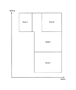
illustrated in FIG. 1. Depicted are four parcels of land, parcels A, B, C and
D, showing
the parcels' actual physical spatial relationship as measured on the ground.
If surveys are
produced for Parcels A, B, and C, and if the relative locations of those
surveys are known
with sufficient accuracy, then the amount of time and effort required to
survey Parcel D
could be dramatically reduced because four of the property lines of Parcel D
are defined
by property lines belonging to Parcels A, B, and C. The area over which a
given survey or
legal description for real property is likely to have influence over the
location of adjacent
or nearby boundaries of other parcels will generally not exceed several square
miles. Of
course not being able to predict which combination of surveys will have a
bearing on
future surveys it would be necessary to be able to spatially relate all
surveys produced.
[0010] A very important characteristic of most two dimensional Cartesian
systems used for legal descriptions is that they have no actual spatial
relationship to each
other, in many cases not even if two parcels are contiguous. In other words,
given the
legal descriptions of two parcels of land that are within a half mile of each
other, it is not
likely that their actual physical spatial relationship can be established
based upon the
descriptions alone. This is illustrated in FIG. 2, which depicts a possible
orientation of the
parcel boundaries based on deed or legal descriptions of the same parcels
illustrated in
FIG. 1. The orientations depicted in FIG. 2 are the orientations that must be
used within
the CAD drawings and associated point databases to produce plats of survey.
Without a
CA 02620870 2008-02-22
WO 2007/024892
PCT/US2006/032835
common coordinate or grid reference system which may be used to tie these
disparate
parcels together, the interpretation might result in the parcels "floating
about in space," as
depicted in FIG. 2.
[0011] One way to establish the actual physical spatial relationship
between two
surveys is to measure from one parcel to the other so as to establish their
relative positions.
Prior to GNSS, if a surveyor wanted to determine the spatial relationship on
the surface of
the earth between every survey performed, the surveyor might have to
physically traverse
on the ground between every one of those surveys using an electronic total
station,
theodolite, EDM, or other suitable measuring device. Even if it were feasible
to do this, it
would not be possible to do so with sufficient accuracy due to the large
propagation of
error that would result. With the advent of GNSS and the coming on line of
over 1000
Continuously Operating Reference Station (CORS) control points throughout the
United
States, the situation has changed with regard to coordinating and referencing
different
surveying jobs.
[0012] A CORS control point is a permanent fixed GPS antenna and receiver
that records GPS satellite signals 24 hours a day, 7 days a week, and
transmits that data as
soon as it is collected to the National Geodetic Survey (NGS) where it
immediately
becomes available at no cost to anyone with Internet access (NGS is a branch
of the
National Oceanographic and Atmospheric Administration (NOAA)). The location of
every CORS antenna and its electronic phase center is known and monitored with
extraordinary accuracy in relation to a comprehensive continental coordinate
system and
datum called "NAD 83 (CORS)." The coordinates of the CORS are given in terms
of
geodetic latitude, longitude, and ellipsoid height defined on the WGS84
ellipsoid, a
mathematical surface designed to approximate the shape of the earth. These
highly
6
CA 02620870 2008-02-22
WO 2007/024892
PCT/US2006/032835
accurate coordinates are down loadable from NGS websites. The network of
National and
Cooperative CORS constitutes the National Spatial Reference System.
[0013] An NGS Web site defines the NSRS as follows:
"The National Spatial Reference System (NSRS), defined and managed by
the National Geodetic Survey (NGS), is a consistent national coordinate
system that specifies latitude, longitude, height, scale, gravity, and
orientation throughout the Nation, as well as how these values change with
time."
"NSRS consists of the following components:
= A consistent, accurate, and up-to-date National Shoreline;
= the National CORS, a set of Global Positioning System
Continuously Operating Reference Stations meeting NOAA
geodetic standards for installation, operation, and data distribution;
= a network of permanently marked points including the Federal Base
Network (FBN), the Cooperative Base Network (CBN), and the
User Densification Network(UDN); and
= a set of accurate models describing dynamic geophysical processes
affecting spatial measurements."
"NSRS provides a highly accurate, precise, and consistent geographic
reference framework throughout the United States. It is the foundation for
the National Spatial Data Infrastructure (NSDI), a critical component of the
'information superhighway.' NSRS is a significant national resource - one
whose value far exceeds its original intended purpose."
7
CA 02620870 2008-02-22
WO 2007/024892
PCT/US2006/032835
[0014] Surveyors may use an extremely accurate type of positioning utilizing
GPS, known as dual frequency relative positioning, which requires that two or
more GPS
receivers operate simultaneously receiving and recording satellite data from
common
satellites. With the two or more GPS receivers operating simultaneously and
receiving
signals from common satellites, the satellite data recorded by the receivers
can be
downloaded to a computer and post-processed using software designed for that
purpose
(GPS that utilizes post-processed vectors is called static GPS). The result is
a highly
accurate vector within WGS84 defining the relative position of the two GPS
antennas.
Very importantly, if the absolute position of one of the antennas is known and
held fixed
within the NSRS, then the vector derived from post-processing is no long
relative and
determines the absolute position of the second antenna or point.
[0015] When surveyors use dual frequency relative positioning GPS, one of the
two GPS antennas is usually called a base station and remains positioned over
a control
point in the ground for many hours at a time, sometimes over successive days.
The other
antenna and receiver is called the rover and is moved from point to point with
short
occupation times in order to establish real time kinematic (RTK) GPS vectors
or post
processed static GPS vectors relative to the base station. If, in addition to
deriving RTK
and or static vectors between the base station and rover, vectors are also
derived between
the base station and one or more CORS through static post-processing, then
highly
accurate absolute positions for both the base station location and the points
located by the
rover relative to the base station can be computed within the NSRS. Because
many large
survey firms now employ GPS routinely in connection with most of their
surveys, it may
be possible for them to practically establish the absolute (within the NSRS or
some other
encompassing coordinate system) and therefore relative positions of those
surveys to a
8
CA 02620870 2008-02-22
WO 2007/024892
PCT/US2006/032835
very high degree of accuracy. Any measurement errors in the vectors from three
or more
CORS to the base station can be adjusted, for example by the method of least
squares,
holding the published CORS coordinates fixed. Such an adjustment computation
may
result in positions for the base station, and the associated points within a
particular survey
job, that exceed in accuracy the positions that could be achieved through the
use of
conventional traverses run by using electronic total stations and tying the
surveys to
conventional ground control stations. These higher levels of accuracy can be
achieved
virtually every time with generally two hours of observation at the base
station by post
processing base station GPS data with CORS control point data that has been
downloaded
from NGS websites. The CORS data may have been collected hundreds of miles
from the
base station and the site of the survey.
[0016] A few states in the United States have what are called virtual
reference
systems (VRS). Europe is blanketed by such systems. A VRS is a network of CORS
that
immediately relay their data to a central computer that then models the
atmospheric
corrections over the area encompassed by the network. These atmospheric
corrections are
then conveyed via cell phone to UPS rovers operating in the field. The result
is real time
or RTK positions at the rover without the need for a base station set up near
the site of the
survey. In the United States VRS systems are all operating on the NSRS and NAD
83
(CORS). Therefore a surveyor who is operating in a VRS is automatically
establishing a
link between local survey points and an encompassing coordinate system, in
this case the
NSRS.
[0017] In order for UPS located points to be usable for spatially relating
unconnected surveys in a high accuracy survey-grade GIS their WGS84 latitude
and
longitude coordinates must be transformed into grid coordinates by defining a
map
9
CA 02620870 2008-02-22
WO 2007/024892
PCT/US2006/032835
projection. The term "grid" refers to a Cartesian coordinate system that is
the result of a
map projection. A map projection projects points on a curved surface onto a
conical or
cylindrical three dimensional surface which can be cut and laid flat, thereby
transforming
coordinates for points located in three dimensions on a curved and irregular
surface into
points represented in a flat two dimensional frame. A map projection typically
includes an
ellipsoid designed to approximate some aspect of the earth's surface (such as,
but not
limited to, mean sea level) and a conical or cylindrical surface passing
through or around
the ellipsoid onto which points on the surface of the earth are projected.
From a simple
geometric standpoint that can be visualized, a projection can be accomplished
by
projecting lines from the center of the ellipse through points on the surface
of the earth
(see FIGS. 3, 5). Where the lines intersect the conic or cylinder defmes the
location of the
points in the grid system when the conic or cylinder is cut and laid flat. In
most practical
applications a map projection is a mathematical operation defined by functions
that relate
geodetic latitudes and longitudes in a spherical system to X and Y coordinates
in a two
dimensional Cartesian grid system.
[0018] The tradeoff for representing on a flat surface the relative
size, shape,
and location of figures that exist on a curved surface is that the correct
shapes and
distances as they exist on the curved surface become distorted on the flat
surface. This is
evident to anyone who has seen a flat map of the world and noticed that
Greenland
appears to be larger than the continental United States. The larger the area
of the earth
depicted using a map projection, the greater the distortion. The converse is
also true, as
the area of the earth encompassed by a map projection becomes smaller so to
can the
distortion. Because the areas over which it may be desirable to spatially
relate surveys is
on the order of several square miles, it becomes possible to design map
projections that
CA 02620870 2008-02-22
WO 2007/024892
PCT/US2006/032835
reduce the difference between grid distances and ground distances to an order
well within
the measurement tolerances associated with the best practices of land
surveying.
[0019] Because the coordinates that are produced using GPS are in terms of
latitudes and longitudes, which are defined in a three dimensional spherical
frame, these
coordinate systems cannot be used as a basis for spatially relating legal
descriptions which
are defined within two dimensional Cartesian coordinate systems, as are
required in the
development and processing of local land surveys. The local land surveys are
typically
referenced to a locally optimized coordinate system and may be arranged so
that a
computed grid distance and a measured ground distance are within an acceptable
level of
tolerance for any location where the local coordinate system may be used.
[0020] It is desirable that improvements to the processing of
coordinates for
disparate surveying jobs in a particular geographic area be made so that
surveys of
different origins and dates can be compared and harmonized with each other.
SUMMARY
[0021] Virtually real time availability via the Internet of data from
the current
network of over 1000 Continuously Operating Reference Stations (CORS), in
conjunction
with a similar availability of precise GPS satellite orbital data (necessary
for accurate post
processing over long distances), allows any surveyor with dual frequency GPS
receivers to
determine, with extraordinary accuracy, the location of a point within the
NSRS, and
therefore a survey within the NSRS, after only several hours of logging
satellite data at a
base station and post-processing that data to multiple CORS that are hundreds
of miles
away. The static vectors from three or more CORS can be adjusted by the method
of least
squares holding the published CORS coordinates fixed. This results in
positional accuracy
11
CA 02620870 2008-02-22
WO 2007/024892
PCT/US2006/032835
within the NSRS that exceed the day to day conventional traverses run by
surveyors using
electronic total stations.
[0022] Although it is now possible to very accurately determine the physical
position all surveys in relation to each other, most plats of survey must be
produced and
drafted on individual Cartesian coordinate systems that have no spatial
relationship. The
problem then becomes how to transform the drawings and databases of multiple
surveys
on multiple unrelated coordinate systems to a common system that results in
grid
coordinates as being ground coordinates.
[0023] County Coordinate Systems, such as those developed for the state of
Wisconsin by the Wisconsin Department of Transportation, can in some areas
provide one
solution to the multi-coordinate system problem. County Coordinate Systems
have unique
map projections for each county that reduce the difference between grid and
ground
distances to a negligible level. If two or more points from a survey are tied
to the NSRS,
which represents an encompassing coordinate system in latitudes and
longitudes, and
transformed to a map projection for a Wisconsin County Coordinate System, and
if these
same points exist in the drawing database used to produce the survey, then a
relationship
exists between the coordinate system in which the survey is produced and the
County
Coordinate System, where grid distances are virtually ground distances over
several miles
in many areas of the state of Wisconsin. Transformation of a survey drawing
file and
associated point database into a County Coordinate System then becomes a
simple non-
scaled translation and rotation defined by the points common to both systems.
In this way
otherwise unconnected surveys can be spatially united on a common coordinate
system
that retains ground distances as grid distances over areas as large as several
miles.
12
CA 02620870 2008-02-22
WO 2007/024892
PCT/US2006/032835
[0024] GIS software is the ideal engine for transforming multiple surveys into
a
common coordinate system. GIS software can access drawing databases and GPS
post
processing/adjustment databases and identify common points. For each survey
drawing
and point database chosen for transformation, the GIS finds specially tagged
points in a
GPS post processing/adjustment database in a County Coordinate System. The GIS
software then finds the corresponding point numbers in the survey database
used to draft
each survey. Corresponding coordinates representing the same physical points
in two
separate coordinate systems define a unique transformation applied to each
survey to
transform each survey into the appropriate County Coordinate System.
[0025] In the process of producing a survey, it is not uncommon for a drawing
and associated database to go through several translations and rotations in an
attempt to
arrive at the best boundary solution. Because the transformation to a County
Coordinate
System is defined by points that exist within a survey drawing database,
translating and
rotating that database does not alter the transformation to the county system.
[0026] It is an object of this invention to provide a method whereby any
number
of land survey electronic drawing files, or any electronic drawing
representing measured
features on the surface of the earth, along with associated or attached point
databases, can,
be spatially integrated and combined with high survey-grade accuracy within a
Geographic Information System and not introduce any meaningful distortion in
distances
as measured on the ground. It is a further object of this invention that the
spatial
integration will be based on the current condition, in terms of orientation,
of the surveys
integrated. It is a further object of this invention that the point data and
drawing features
so integrated can be exported into new drawing and point databases in such a
manner that
the source of the exported point information can be traced to its original
database. It is a
13
CA 02620870 2008-02-22
WO 2007/024892
PCT/US2006/032835
further object of this invention that such method will not hinder or disrupt
in any way the
customary office procedures employed within survey departments to produce
plats of
survey and to manage point databases.
BRIEF DESCRIPTION OF THE DRAWINGS
[0027] The drawings illustrate the best mode presently contemplated of
carrying
out the invention. In the drawings:
[0028] FIG. 1 is a depiction of the actual spatial relationship between
four
parcels of land;
[0029] FIG. 2 is a depiction of the same four parcels of land with bearings
and
distances from deed or legal descriptions;
[0030] FIG. 3 is an illustration of a State Plane Coordinate system map
projection;
[0031] FIG. 4 is a depiction of the dimensions of a parcel of land on both a
State Plane Coordinate grid system and as measured on the ground per a legal
description;
[0032] FIG. 5 is an illustration of a County Coordinate System map projection;
[0033] FIG. 6 is a depiction of the orientation of three parcels of land and a
transformation of the drawing entities from deed or legal description-based
coordinates
into a single local grid system; and
[0034] FIG. 7 illustrates the transformation of drawing entities and
associated
point databases from deed or legal description-based coordinate systems to a
single local
grid system.
[0035] FIG. 8A illustrates a parcel surveyed on the ground using a total
station
surveying instrument.
14
CA 02620870 2008-02-22
WO 2007/024892
PCT/US2006/032835
[0036] FIG. 8B illustrates the parcel of FIG. 8A with two corners of the
parcel
each occupied by a global positioning system (GPS) receiver.
[0037] FIG. 9 illustrates the downloading of data regarding the survey from
both the total station surveying instrument and the GPS receivers into an
automated
system for analysis.
[0038] FIG. 10A illustrates the surveyed parcel of FIG. 8A with local
coordinates for the GPS points shown.
[0039] FIG. 10B illustrates the GPS points of FIG. 8B with vectors to distant
known control points and one of the points shown, and a vector between the two
GPS
points shown.
, [0040] FIG. 11 illustrates a latitude and longitude computed for the GPS
points
of FIG. 10 from the vectors to the known control points, and a table populated
with
computed latitude and longitude of the first GPS point, a unique identifier
and other data
regarding the first GPS point.
[0041] FIG. 12 illustrates a process of updating a survey project database
within
a geographic information system (GIS) indicating the location of the first GPS
point
computed in FIG. 11.
[0042] FIG. 13 illustrates a process for associating points within the
survey
from the total station with the GPS points, so that coordinates of the GPS
points in two
different coordinate systems are associated with each other.
[0043] FIGS. 14A to 14W are screen shots of a preferred embodiment of the
software for processing two or more surveys into a common local grid
coordinate system
according to the present invention.
CA 02620870 2008-02-22
WO 2007/024892
PCT/US2006/032835
[0044] FIG. 15 is a schematic view of a virtual box drawn about a plurality of
surveying projects represented as dots.
DETAILED DESCRIPTION OF THE PREFERRED EMBODIMENT
[0045] The survey of real property is typically a blending of legal
interpretation
with engineering precision to determine the location of a line demarcating
legal ownership
or other legal interest on the face of the Earth. Once the legal
interpretation of the
evidence of the location of such delineations has been performed, the lines
representing
these delineations can then be measured using conventional engineering and
surveying
techniques. The measurements can then be used to generate maps or other
representations
(both hardcopy and electronic or digital) of the location of the lines on the
surface of the
Earth. The accumulation of these lines in a closed traverse is typically done
to generate a
representation of a parcel of real property rights. As shown in FIG. 1, almost
all parcels
share lines or boundaries with adjoining parcels.
[0046] Surveying a parcel of land typically includes a first task of
reviewing
information such as recorded plats or legal descriptions written in deeds or
other
instruments of ownership. From these plats or legal descriptions, a surveyor
may go into
the field and attempt to locate all of the relevant corners of the parcel on
the ground. This
can be accomplished through a combination of measuring from other corners of
the parcel,
recovering prior monuments indicating where the corner may be located, or
using other
reference marks, monuments or geographic features. Once the corners of the
parcel have
been located, the actual measurement of the locations can commence. While the
plat or
legal description may generally locate the parcel on the face of the Earth
with reference to
existing geographic or legal features, the location of the actual corners of
the parcel to be
16
CA 02620870 2008-02-22
WO 2007/024892 PCT/US2006/032835
measured is dependent on a set of legal and evidentiary guidelines and the
interpretation of
the surveyor.
[0047] When surveying a particular parcel, examination of one or more earlier
surveys of one of more adjacent or nearby surveys might be useful and many
times
mandatory for the surveyor in determining the lines of the parcel in question.
As noted
above, a survey of parcel D may be aided by the knowledge of the lines derived
during
earlier surveys of parcels A, B, and C. Such earlier surveys may be used to
verify the
location of the common lot line between adjacent parcels. However, even if the
existence
of a prior survey of an adjacent parcel is known, depending on field
measurement data
collected and the means of reduction of the data to produce the map or other
depiction of
the adjacent parcel, the line work of the earlier survey may not be useable by
the surveyor
of the current survey. This lack of usability of the earlier survey results
may be caused by
differences in the error tolerances between the earlier survey and the present
survey,
differences in the map projection used and the coordinate system in which the
surveys are
to be generated, as well as the use of disparate control points or control
reference networks
between the surveys.
[0048] It is desirable that a common reference framework be used to ensure
that
surveys at least are tied to a consistent level of control. It is also
desirable that the results
of surveys be presented in coordinate systems or projections which permit
adjacent or
nearby surveys to be relatively positioned with respect to each other with a
low level of
ground distance distortion in the projection of the location of points of a
survey into grid
coordinates.
[0049] All states within the Unites States have official State Plane
Coordinate
(SPC) systems which are grid coordinate systems generated by map projections
designed
17
CA 02620870 2008-02-22
WO 2007/024892
PCT/US2006/032835
to encompass one or more regions or zones within a state. Because of the large
size of the
areas encompassed by SPC systems, the distances between points as measured on
the
ground are shorter or longer in comparison to distances given in the grid
systems. In the
state of Wisconsin for example, the difference between ground distance and SPC
grid
distance can be as high as 1.0 feet over a distance of one mile. The
difference between
ground and grid distance increases as the separation of two points increases
(See FIGS. 3
and 4). Spatially relating legal descriptions and plats of survey using SPC
grid systems
may introduce an unacceptable amount of distortion in distances derived from
computed
grid coordinates and actual ground distances measured. This is due to the SPC
system
being optimized to fit the state as a whole, where there may be distinct land
forms and
other geographic features. As the SPC system has to average all of these
statewide
distortions, in any given location within the state, the difference between
grid and ground
distances may be unacceptable.
[0050] The Wisconsin Department of Transportation has developed the
Wisconsin County Coordinate System that defines a local map projection for
each county
in the state of Wisconsin. These grid systems are based on map projections
that are
designed to encompass and be optimized for no more than one county. As a
result, the
difference between county coordinate grid distances and ground distances in
many
counties, and over areas spanning several miles, is insignificant compared to
the errors of
measurement associated with the best practices of land surveying. The
Wisconsin County
Coordinate System may therefore be a suitable grid system in some areas for
the
transformation of GPS derived latitudes and longitudes into map projected
coordinates for
the purpose of spatially relating unconnected surveys.
18
CA 02620870 2008-02-22
WO 2007/024892
PCT/US2006/032835
[0051] Survey
crews using electronic total stations and GPS may perform field
measurements and computations for a property survey and then utilize a local
Cartesian
coordinate system appropriate for or specified for the deed or legal
description for that
property. In carrying out the survey in the field, the points to be surveyed
may be
determined and marked, as noted above. A GPS base station is allowed to run
for several
hours during the survey at a base point within the parcel or parcels to be
surveyed, while a
GPS rover occupies and makes observations at the marked points and any other
points of
interest in the survey area. As an alternative to use of a GPS rover to visit
all of the points
of interest within the survey, more traditional traversing may be carried out
to locate
points within the survey area. For example, such traversing could be carried
out through
the use of a total station, provided these traverses are tied to at least two
of the points
included in the GPS survey. For example, the traverse could extend between the
point
occupied by the base station and some other point in the survey. Data
collected by the
total station and GPS receivers may then be downloaded into computers at the
office. The
data collected during the survey is in the form of measurements related to a
local assumed
Cartesian coordinate system which is based on location information of the
recorded plat or
legal description. This data is on a local system and is used to draft the
plat of survey.
[0052] GPS data from one or more CORS stations is downloaded from the
Internet into GPS office software, along with precise satellite orbital data.
This CORS
data and orbital data are post-processed in order to derive vectors from the
CORS stations
to the base station at the site of the survey. Once vectors from the
referenced CORS
control points are derived, adjustment computations may be used to calculate
high
accuracy coordinates within the NSRS for the base station within the current
survey area.
A GPS vector for at least one other point within the current survey area must
also be
19
CA 02620870 2008-02-22
WO 2007/024892 PCT/US2006/032835
derived, using relative vectors measured from the base station to the desired
additional
point(s).
[0053] Latitudes and longitudes within the NSRS may then be transformed into
Wisconsin County Coordinates which may be stored within a point database or
some other
form of digital memory for use in later calculations. Data or field notes
relating to any
traverses that were performed using more traditional surveying methods and
which were
tied to GPS points can also be used to compute County Coordinates for any non-
GPS
points included in the traverse.
[0054] In the adjustment computation, coordinates of the CORS stations may be
held fixed in a least squares adjustment, as these coordinates are verified
and calculated to
a very high level of absolute accuracy. Holding these point coordinates as
fixed in the
adjustment computation will thereby improve the accuracy of the NSRS
coordinates
calculated for the base points within the current survey area and will permit
the generation
of probable Easting and Northing errors, or a resulting error ellipse, for the
location of the
base station.
[0055] As an alternative to using post processed GPS vectors from CORS
stations to the site of the survey, a VRS may be used. In this case there may
not be a base
station at the site of the survey. If VRS is used exclusively then the rover
must take
measurements on at least two points on the survey.
[0056] The same procedures may used for a second survey of a contiguous,
overlapping, adjacent or nearby unconnected survey. This is shown in FIG. 2.
As shown
in FIG. 1, the actual layout of the parcels on the ground has the parcels
arranged in a
particular orientation. When each parcel is surveyed using its internal
coordinate system,
(as indicated by the bearings included with each of the measured boundaries),
the parcels
CA 02620870 2008-02-22
WO 2007/024892 PCT/US2006/032835
wind up oriented as shown in FIG. 2, even though these surveys may be
performed to the
same level of internal accuracy in the measurement and adjustment of the
relative
locations of the points within each survey.
[0057] The net result of the preceding process may be two point databases or
more broadly two sets of points from two distinct surveying jobs which may be
in two
different coordinate systems.
[0058] It should be noted that for the purposes of this approach to
coordinating
surveyed points in different coordinate systems, it is assumed that each of
the surveys
involved include an acceptable level of internal integrity. In other words,
the angles
turned and distances measured (assuming a theodolite was used), or the
relative GPS
positioning between points of the survey are all of high enough accuracy and
have been
adjusted as necessary to apportion or eliminate systematic or random errors
according to
normal surveying adjustment computations. Once the internal integrity of these
surveys
has been established and coordinates in some required or chosen coordinate
system have
been computed, the approach disclosed in the present disclosure may be used to
bring
points portrayed in different coordinate systems to a common geographic base.
[0059] Because the internal integrity of each survey is presumed to be of an
acceptable level, it is desirable that the geometry of each survey be held
fixed during the
relating of the different surveys to a common coordinate base. In the example
shown in
FIGS. 1 and 2, it should be noted that each of the surveys in FIG. 2 have
acceptable
internal geometry. Note that the rightmost boundary of Parcel B and the
rightmost
boundary of Parcel C are actually parallel as they exist on the ground (as
shown in FIG. 1)
while they are depicted as differing in bearing by over seventeen degrees in
FIG. 2. In this
example, all three of the surveys depicted are internally accurate but
projected into distinct
21
CA 02620870 2008-02-22
WO 2007/024892 PCT/US2006/032835
coordinate systems, where collinear or parallel sides do not appear to line up
with each
other. While this is exaggerated for the purposes of this example, it serves
to illustrate that
although each survey might be internally geometrically acceptable, its
external geometry
might not be acceptable.
[0060] One conventional approach to bringing these two surveys together
would require that all of the points in one or both surveys be readjusted.
Such a
conventional approach might include a comprehensive least squares or other
similar
readjustment approach, which might allow all of the points to be readjusted
without any
regard for the original geometry of the surveys. However, since it is
desirable to hold the
internal geometry of each survey fixed through the computations, only
translations and
rotations of the constellation of points as a group are performed, according
to the present
invention. To accomplish this translation and rotation, at least two points
are required.
[0061] In general terms, two or more points from each survey will be used to
accomplish any required or desired rotation and translation of that survey,
while bringing
each survey to a common geographic base or projection. While the translation
and
rotation may be referred to as being applied to the survey as a whole, the
rotation and
translation of each survey are actually carried out by computing new
coordinates for each
of the points defining endpoints or intermediate vertices of line segments
within each
survey. Such a translation and rotation of a survey may also include the
computation of
points related to the survey but which are not associated with or part of a
boundary line,
such as geographic or manmade features measured in the field and/or located on
the
survey plat. Each survey can be rotated as necessary to bring the geometries
of each
survey into alignment, as shown in FIG. 7. A general approach to accomplishing
this
translation and rotation of the different surveys is described below as an
example of one
22
CA 02620870 2008-02-22
WO 2007/024892
PCT/US2006/032835
embodiment of the present invention. The description of the preferred
embodiment below
in not intended to limit the scope or nature of the present invention and is
provided as an
illustrative example only.
[0062] In FIGS. 8 to 13, illustrations of the portions of the preferred
embodiment are provided. The preferred embodiment described below illustrates
how
each survey is processed from field data collection to preparation for
transformation to a
local grid coordinate system in conjunction with another survey. While the
transformation
of coordinates into a local grid coordinate system for a single survey may be
carried out
independently of any other survey, typically, two or more surveys which are
adjacent or
nearby to each other will be processed at generally the same time or
simultaneously.
[0063] FIGS. 8A and 8B illustrate two representations of a survey of a parcel
100, with FIG. 8A showing a total station 10 being used to traverse the parcel
or measure
distances and angles between points and lines defining a boundary of the
parcel. FIG. 8B
shows a first GPS receiver 12 ("A") and a second GPS receiver 14 ("B")
positioned at two
points or corners of the parcel that have been included in the traverse
measured by total
station 10.
[0064] FIG. 9 shows the data from the various surveying instruments being
downloaded to an office computer 16. The environment of office computer 16 may
define
or be a part of a GIS. Data from total station 10 is downloaded to and
processed by a
computer aided drafting (CAD) software package 18 and a drawing of the parcel
surveyed
is compiled with an associated point database. These coordinates are computed
in a local
coordinate system appropriate for the particular survey. Data from GPS
receivers 12 and
14 are downloaded to a GPS post processing software package 20 and an
associated point
database is compiled from the data. Data from the CORS stations is downloaded
into the
23
CA 02620870 2008-02-22
WO 2007/024892
PCT/US2006/032835
GPS post processing software and vectors are derived from the CORS stations to
the base
point number 1 linking point number 1 to the NSRS. A GPS vector is also
derived from
point number 1 to point number 4 which ties point number 4 to the NSRS. The
GPS post
processing software is then used to transform the latitudes and longitudes
within the NSRS
of point number 1 and point number 4 to the applicable county coordinates.
[0065] In FIG. 10A, parcel 100 is illustrated as the CAD drawing, with all of
the measured and corrected distances and angles defining the internal geometry
of the
parcel measured on the ground by total station 100. Note that local
coordinates are
computed for both of the points occupied by GPS receivers 12 and 14. In FIG.
10B, GPS
receivers 12 and 14, as they were positioned at the points of parcel 100, are
illustrated with
measured vectors to a plurality of known CORS control points which are located
outside
of parcel 100. The descriptions of points 1 and 4 are modified to indicate
that there are
GPS derived grid coordinates for these points.
[0066] FIG. 11 shows a table being populated with the latitude and longitude
of
point 1, derived from the GPS measured vectors. The lat/long of point 1 can be
used to
locate the survey of parcel 100 with regard to other surveys so that these
surveys can be
quickly located for reference in future projects or surveys and so that they
can appear in
their correct relative locations as points on a map in the GIS system.
[0067] The point description of a point that represents the central
location of the
survey in the GPS database on the County Coordinate System is modified to
include the
text string "WGS84" (this text string is arbitrary and other text strings or
identifiers could
be used; the inclusion of this text string could also be done in the field at
the time of data
collection). The point descriptions of two points in the GPS database County
Coordinate
System are modified to include respectively the text strings "GPS1" and "GPS2"
(this text
24
CA 02620870 2008-02-22
WO 2007/024892 PCT/US2006/032835
string is arbitrary and the modification could also be done in the field at
the time of data
collection).
[0068] A project point extraction software routine is launched which is used
to
extract information from the GPS database on the Wisconsin County Coordinate
System.
This information is used to populate a project point database that contains a
field related to
the survey project number, a field for the latitude of the point with WGS84 in
its
description, a field for,the longitude of the point with WGS84 in its
description, and a field
for the county in which the survey resides.
[0069] When a survey project number is entered into a field in the project
point
extraction software, the software goes out to the GPS database associated with
the survey
project number, it searches that database for the point with WGS84 in its
description field,
it then extracts from that database the latitude and longitude for the WGS84
point and the
county in which the survey resides and populates the corresponding fields of
the project
point database with this information.
[0070] GIS software 30 may now be launched, as shown in FIG. 12. This
software contains the routines and tools for completing the process of
spatially relating the
CAD drawings and associated point databases of different surveys. These tools
are
illustrated in FIGS. 12 and 13, and the screen shots attached collectively as
FIGS. 14A to
14W.
[0071] The "Update County project points" tool updates a shape file with the
information contained in the project point database. This shape file is used
to display the
location of surveys as project points on a map of the state of Wisconsin.
These locations
are based on the latitude and longitude of the WGS84 modified point
description
associated with each survey.
CA 02620870 2008-02-22
WO 2007/024892
PCT/US2006/032835
[00721 The "Default Layers" tool brings up the "View or Update Default
Layers" dialog box that allows the user to set the default layers that will be
imported into
the GIS from the CAD drawing that is selected for each survey.
[00731 The "Default LDD Codes" tool brings up the "View or Update Default
LDD Codes" dialog box. This box allows the user to set a default code list for
selecting
points from the point databases associated with the CAD drawings.
[00741 The "Select Project Points" tool allows the user to select the
project
points for which CAD drawings and associated point databases for different
surveys will
be transformed into shape files on county coordinates, thereby spatially
relating them.
[0075] Additional dialog boxes may appear as shown in the screen shots.
[0076] When a survey is selected in order to transform its CAD drawing and
associated database, which are on a deed or legal description based Cartesian
coordinate
system, to a County Coordinate System, the GIS may go out to the GPS database
containing the points in the county coordinate system. It searches this
database for the
points with "GPS1" and "GPS2" in the description field. The GIS extracts the
point
numbers for these two points. The GIS then goes out to the point database with
the
Cartesian coordinate system based on the deed or legal description that
produced the
survey and drawings. The GIS searches this database for the point numbers that
were
extracted for "GPS1" and "GPS2." The GIS then extracts CAD drawing layer
entities and
points from the associated point database and translates and rotates them
based upon the
coordinates for "GPS1" and "GPS2" in each coordinate system (See FIGS. 6 and
7).
[0077] It is also anticipated that a completely arbitrary grid
coordinate system
may be defined on the fly and selected to use as a basis for associating
and/or registering
two or more nearby survey projects. Such an arbitrary grid coordinate system
might be
26
CA 02620870 2008-02-22
WO 2007/024892 PCT/US2006/032835
used when the survey projects of interest are located across jurisdictional
boundaries from
each other, such as county or state lines. Often, surveys in different
jurisdictions must be
expressed in different coordinate systems as mandated by the local or state
government.
As an example, in Wisconsin, under a prior state defined and mandated county
reference
framework, a plurality of county level coordinate systems were defined (some
covering a
single county, others covering a plurality of counties), each using a slightly
different
defined ellipsoid. There are mathematical relationships defined between each
local
coordinate system and each defined ellipsoid, permitting coordinates to be
transformed
between the different county coordinate systems. However, for relating survey
projects
lying in different jurisdictions, coordinates of points within one or more of
the projects in
a first jurisdiction will need to be transformed into coordinates of a
different jurisdiction,
which may introduce coordinate distortions. Another reason to be able to
define a grid
coordinate system on the fly is that few states have county coordinate
systems. Another
reason is that even if county coordinate systems exist they may not, do to
elevation
differences and or the size of the county, result in grid distances being
sufficiently close to
ground distances over several miles in some areas. Another reason to be able
to create
local grid systems on the fly is so that the GIS will operate in any country
regardless of the
existence of suitable preexisting grid coordinate systems.
[0078] According to the present disclosure, an arbitrary coordinate system can
be defined as needed to encompass only those survey projects of interest. With
reference
to FIG. 15, using a point 502 within each project, for example but not limited
to, a point
where a GPS base station was positioned, a virtual box 500 can be defined to
encompass
the northing and easting of each point 502 of the selected projects. A central
location 504,
such as a centerline, central meridian or center point of virtual box 500 can
be derived.
27
CA 02620870 2008-02-22
WO 2007/024892
PCT/US2006/032835
From this derived central line or point 504, an elevation for virtual box 500
with respect to
a standard ellipsoid can be calculated. This elevation can be, for example,
derived from a
standardized national model or some other large scale consistent model. As an
alternative,
the virtual box elevation could be calculated as a mean of a derived elevation
for a
plurality of points within virtual box 500.
[00791 This derived elevation can be used to define the local map projection
which may be used to provide a common basis for the projects within the
virtual box. The
local map projection can be based on whatever projection may be appropriate
for the size
and shape of the virtual box, which is in turn based on the relative positions
of the survey
projects to be transformed. Common examples of suitable projections include,
but are not
limited to Transverse Mercator and Lambert Conformal conic projections. Any of
these
local projections may be based on the same ellipsoid with the derived
elevation providing
a mean height above the ellipsoid for the projection to be located. By
defining the box to
encompass all of the survey projects of interest, the local ad hoc grid
coordinate system
can be chosen to optimize a fit with a minimum grid-to-ground discrepancy, and
to have
the area(s) of least discrepancy between grid and ground distances within the
local
coordinate system projection to be centered over the area of interest. Larger,
predefined
coordinate systems and projections, such as a county-wide coordinate system
may not be
optimally sized or positioned for the particular area of interest Or, the
survey projects of
0 interest may lay on different sides of a jurisdictional boundary to which
the predefined
local coordinate system and projection were made to fit, so that a non-optimal
extension of
the predefmed coordinate system is necessary to encompass all of the projects.
[00801 Once this ad hoc local projection has been defined and calculated for
the
specific projects of interest, the process of defining translations and
rotations can be
28
CA 02620870 2008-02-22
WO 2007/024892 PCT/US2006/032835
performed, as described above. This would generally involve using the various
GPS or
other National Spatial Reference System (NSRS) positioned points within each
project to
define translations and rotations to be applied to calculate local grid
coordinates for each
point of each project. The translations and rotations can then be applied to
the various
i projects to provide coordinates for each point in the local grid
coordinate system. Again,
as noted above, the selection of the local projection is intended to permit
calculation of
coordinates for the points within each project so that calculated grid
distances derived
from the coordinates will match the actual distances measured on the ground.
It is
desirable that, while the difference between grid-derived and ground-measured
distances
may not be absolutely identical, these distances should match within a
specified level of
significance.
[0081] If a virtual box is defined by projects that are separated
too far
geographically and/or elevation-wise to conform with a maximum allowable error
between grid-derived and ground measured distances, the system and method of
the
present disclosure may still permit the projects to be moved with respect to
each other but
may highlight that the potential error is beyond the statutory or
professionally mandated
limits. While it may be desirable to have maximum potential error between
surveys
transformed to a common local coordinate system meet professional or statutory
standards, there may also be other reasons for coordinating surveys that do
not require that
these standards be met.
[0082] Using the system and methods of the present disclosure, it is
possible to
adjust or transform any group of two or more survey projects to a common local
coordinate system. Each of the survey projects to be transformed needs to have
control
points within the survey database that are tied to a national spatial
reference system or
29
CA 02620870 2008-02-22
WO 2007/024892 PCT/US2006/032835
some earth-centric or encompassing coordinate system. The control points
within each
survey project do not need to be directly referenced to the same coordinate
system for the
disclosed system and methods to operate. So long as the control points are
referenced to
coordinate systems or projections which can be mathematically related. If the
control
points are referenced in different coordinate systems or projections, it may
be necessary to
perform an intermediate coordinate transformation to one or more of the survey
project
point databases prior tp the definition of the local coordinate system to
which all of the
survey projects will be related.
[0083] Various alternatives and embodiments are contemplated as being within
the scope of the following claims particularly pointing out and distinctly
claiming the
subject matter regarded as the invention.