Note: Descriptions are shown in the official language in which they were submitted.
CA 02627989 2011-11-07
System. Apparatus and Method for Mapmina
Field Of The Invention
[0002] The present invention relates generally to cartography and more
particularly relates to mapping of urban regions.
Background of the Invention
[0003] The twentieth century, particularly, saw the exponential growth of
urban
regions throughout the world, and in its latter half, the quantum development
of suburban
districts around the peripheries of cities, fuelled by expressways and the
dominance of the
automobile-based society. This condition, in which the majority of North
Americans, for
example, now live in suburbs with low rates of built density and human
activity, is
generally unable economically to sustain mass transportation. Residence, work,
shopping
and leisure are not only low in density, and highly land consuming, but
activities are
generally segregated and separate. In consequence, there is now widespread
concern for
the effects of such dependence on the automobile -- in air pollution, greatly
increasing
delays, in the increasing aggregate traveling that decreases the quality of
peoples lives in
costs, time and difficulties in getting to jobs, and in many other respects.
[0004] A range of policies and practices have been promoted to deal with this
situation, developing forms of land use and transportation in combination, so
as to
conserve energy, minimize emissions of pollutants, encourage accessibility
while
minimizing mobility -- for example, by developing intensive activity centres
around
public transport nodes. Regions around the globe are involved in efforts to
translate thew
ambitions into regional strategic development frameworks.
-1-
CA 02627989 2008-04-25
[0005] In general, as the world population becomes more concentrated in urban
regions, the quality of life in any given urban region is greatly affected by
how well the
urban region is equipped with infrastructure to support the needs of the local
population.
Urban planning is a well-known discipline that is used to plan how such
infrastructure is
added, replaced and maintained. Urban planning also encompasses a number of
other
issues as will occur to those of skill in the art.
[0006] At least in developed countries, most urban regions implement varying
degrees of urban planning. The process is often heavily influenced by
political factors, as
issues around taxation and property rights are necessarily intertwined with
the urban
planning process. Recently in North America, there has been a trend towards
"lean
government" policies, wherein government-based centralized urban planning is
largely
abandoned in favour of allowing the urban region to grow in a laissez-faire
manner, on the
belief that the free market is the best determiner as to how the area should
grow. Still
other administrations may implement a more activist policies, involving a
great deal of
centralized planning, with the view that government controlled central
planning is the
most efficient way to serve the needs of the local population. Of course, the
approach for
any given region usually lies between these extremes. Regardless of the chosen
approach, one problem with prior art urban mapping and data collection
techniques is that
there is little in the way of hard-data that can be analyzed to provide an
objective view as
to how urban planning can be implemented most effectively.
[0007] The hard-data that exists today, which has beer, collected
inconsistently
across a region, suggests that more data, and the right kind of data, could be
extremely
effective in urban planning. For example, as of 2003, it is known that the
city of Toronto
has a subway system that supports itself largely out of the fare-box, with
little reliance on
government subsidies. It is hypothesized that a major factor contributing to
this
phenomenon is that there is a large population density that lives
("residential district")
adjacent to subway stations, and there is at least one concentrated area in
the downtown
core where that population works ("employment district") that is also adjacent
to subway
stations. A similar phenomenon can be observed in New York. The effort
required to
generate a report to support this hypothesis, however, is enormous, complex,
time-
consuming and costly. As one approach, the effort could involve collecting
street maps
-2-
CA 02627989 2008-04-25
and subway maps of Toronto, and then conducting door-to-door surveys in both
the
residential and employment districts to verify that people are actually using
the subways
to commute to work. Finally, the data collected from the door-to-door surveys
may then
be correlated with the maps to ultimately arrive at a report with a conclusion
that supports
the hypothesis. However, it can be noted that the report includes only a few
sets of data
points, and does not include other data that may influence whether or not
simple densities
of residential districts and employment districts is sufficient to support
subway lines.
Such a report also does not describe the structure of the built environment
which dictates
the densities. Further, such a report is not readily comparable with how other
urban
regions handle transport from residential districts to employment districts,
to provide an
objective assessment as to which urban region is best handling its
transportation needs.
More complex questions as to how a particular urban region functions in
relation to
another will occur to those of skill in the art, and the generation of reports
to answer such
questions will face similar hurdles and complexities.
[0008] As previously mentioned, prior art urban maps are a very useful element
in
the generation of the above-described type of report for urban planning
exercises. Prior art
urban maps principally identify physical characteristics of transportation
routes, and
include identifiers like street names and station names on those maps. The
maps may
include indications as to whether a particular area is more dominated by
residential,
commercial or industrial activity, but little more. In general, such maps are
very useful
for navigating the urban region, but provide limited information when
attempting to
generate complex reports for urban planning.
[0009] More recent urban maps of the prior art offer information that can be
used
for more than simply navigating the urban region. These maps are generated at
least in
part, using remotely sensed data obtained from satellites, air-planes and the
like.
Baltsavias, Emmanuel P. and A. Gruen. "Resolution Convergence: A comparison of
aerial
photos, LIDAR and IKONOS for monitoring cities" in Remotely Sensed Cities,
edited by
Victor Mesev, Taylor & Francis, London, 2003 ("Baltsavias") is one prior art
reference
that discloses an example of such an urban map. Baltsavias includes a review
and
evaluation of the use of current high-resolution remote sensing technologies
including
aerial/digital orthoimagery, Laser-Induced Detection and Ranging ("LIDAR"),
IKONOS
-3-
CA 02627989 2011-11-07
(4-meters per pixel colour and 1 meter per pixel black-and-white optical
satellite
imagery) to extract goo-spatial information such as:
1) digital terrain models ("DTM", an elevation model that is a
representation of the bare surface of the earth with natural and
manmade features removed.);
2) digital surface models ("DSM", also referred to as a "first surface"
model in which man-made and natural features are captured in the
elevation model.); and,
3) an identification of urban objects such as buildings, roads,
14 vegetation, etc, and reconstruction of three-dimensional urban
objects such as buildings.
Baitsavias describes requirements for developing three-dimensional city models
and
briefly describes two commercial applications that have been developed,
lnJECTT'", a
product of INPHO GmbH, Stuggart, Germany and CyberCity Modeler (CC-Modeleim)
marketed by CyberCity AG, Bellikon, Switzerland. Baltsavias describes a
prototype
system, CyberCity Spatial Information System ("CC-SIS") which Is an attempt to
integrate three dimensional city models with a relational database that can be
potentially
linked to external Geographic Information Systems ("GlS") data. In order to
identify
objects, the user manually identifies points onscreen, and only then will the
application
automatically build topology that includes the geometry needed to relate those
points and
identify an object. The application requires the use of digital orthophotos
which are costly
to acquire at the resolution that is necessary to build the city model.
Further, Baltsavias
does not explain how to derive building use or type and its relation to other
buildings in
its immediate proximity or at the city-wide scale. The application does not
allow a user to
assess how a region functions or compares to other urban regions. In general,
Baitsavias
is limited in how it offers to describe and visualize an urban region's
composition and
functions.
10010) Another example of increased urban map sophistication is found in
Barnsley, Michael )., A.M. Steel, and S. Barr. "Determining urban land use
through an
-4-
CA 02627989 2008-04-25
analysis of the spatial composition of buildings identified in LIDAR and
multispectral
image data," in Remotely Sensed Cities, edited by Victor Mesev. Taylor &
Francis,
London, 2003. ('Barnsley"). Barnsley uses a combination of IKONOS at 4 meters
per
pixel colour satellite imagery and LIDAR (2 m) image data at 0.4 point
sampling density
per square-meter, to extract the existence of building objects from other
surrounding
objects, such as trees or paved roads. The results of the extraction were
compared to base
data to gage accuracy of results. Four test areas are used where the
predominant land use
is either residential or industrial. Given the limitations of the data sets
several thresholds
were applied to the data to improve the results. Barnsley develops a graph-
based pattern
recognition system to infer land use by height and structural configuration.
The
technology and techniques used in Barnsley to extract building objects semi-
automatically
and to identify differences in morphological properties of buildings and the
structural
composition of built form patterns were successful in differentiating general
land use
types, (e.g. residential versus industrial), but there were problems in
identifying and
characterizing unique patterns within these general land use types, different
residential
and industrial patterns were not able to be characterized given the
measurement
techniques used. In general, Barnsley does not teach how to classify and
describe the
unique built form for different residential and industrial uses.
[0011] An example of an as-yet unfulfilled attempt to provide a more
sophisticated urban map is found in Eguchi, Ronald, C. Huyck, B. Houshmand, D.
Tralli,
and M. Shinozuka. "A New Application of Building Inventories using Synthetic
Aperture
Radar T; chnology.", presented at the 2nd Multi-Lateral Workshop on
Development of
Earthquake and Tsunami Disasters Mitigation Technologies and their Integration
for the
Asia-Pacific region. March 1-2, 2000. Kobe, Japan. ("Eguchi"). Using
Interferometric
Synthetic Aperture Radar (IFSAR) airborne technology, aerial photography and
county
tax assessment data, Eguchi attempts to identify building types based on
building
footprint and height which they extract from the remotely sensed data and
validate results
using county tax assessment data. The preliminary results of the techniques
used and
future research plans are presented in Eguchi, laying the groundwork to work
towards a
building inventory at a city-wide scale from which they can measure building
density and
development. Despite the groundwork that has been laid, there is no indication
of success
or how such success will be achieved.
-5-
CA 02627989 2008-04-25
[0012] Another example is Mesev, Victor. "Urban Land Use Reconstruction:
Image Pattern Recognition from Address Point Information.", presented at the
International Archives of Photogrammetry, Remote Sensing and Spatial
Information
Sciences Conference, Regensburg, Germany, 27-29 June, 2003. ("Mesev"). Mesev
examines the use of address point data collected by the Ordnance Survey in the
UK to
examine spatial patterns of development in Bristol UK. The address point data
contains
information on general land use types, residential versus commercial, and
Mesev attempts
to identify differences between different areas of the same land use type,
e.g. residential
#1 and residential #2, based on a various spatial indices/techniques, i.e.
density of points
and nearest neighborhood analysis. This information from this spatial
recognition system
is used to inform muhispectral image classifications of urban regions. Mesev
introduces
some preliminary results used on fine resolution aerial photography provided
by a
company called Cities Revealed (The Geolnformation Group, Telford House,
Fulbourn,
Cambridge, CBI 5HB. United Kingdom -- http://www.crworld.co.uk). The remote
sensed imagery for Cities Revealed is quite costly to acquire for a large
urban region. The
data used for the pattern recognition is unique to the UK but not available
for all regions,
since the UK can rely so heavily on the UK Ordnance Survey. Likewise the
spatial indices
are not fully successful on other urban land use classes such as commercial
and industrial
where information on building characteristics would be more useful than just
the
arrangement of buildings.
Summary of the Invention
[0013] It is an object of the present invention to provide a novel method and
system for mapping that obviates or mitigates at least one of the above-
identified
disadvantages of the prior art.
[0014] An aspect of the invention provides a map of an urban region comprising
a
first set of indicia representing physiographic characteristics of said region
and a second
set of indicia representing a plurality of different types of built forms, and
their locations,
that are located within said region. The map also includes a third set of
indicia
representing patterns of human activity associated with both said
physiographic
characteristics and said built forms.
-6-
CA 02627989 2008-04-25
[0015] Another aspect of the invention provides an apparatus that includes
remote
sensing equipment that is connected to a computer processor. The remote
sensing
equipment gathers imaging data about an urban region. The computer processor
interprets the imaging data to generate a map of the urban region comprising
representations that identify a first set of indicia representing
physiographic
characteristics, a second set of indicia representing different types of built
forms, and a
third set of indicia representing patterns of human activity associated with
both the
physiographic characteristics and the built forms. The map can also include a
fourth set
of indicia representing an intensity level that at least one of the other
types of indicia
occurs.
Brief Description of the Drawings
[0016] The present invention will now be explained, by way of example only,
with reference to certain embodiments and the attached Figures in which:
Figure l is a representation of a section of a geographic territory containing
a number of urban regions;
Figure 2 is a representation of an area within an urban region in the
territory of Figure l being remotely sensed;
Figure 3 is a representation of the remote sensing being performed in
Figure 2 in greater detail;
Figure 4 is a representation of the remote sensing being performed in
Figure 3 in greater detail;
Figure 5 is a representation of the data sensed in Figures 2-4 being inputted
into an apparatus for generating a map in accordance with an embodiment
of the invention;
Figure 6 is a representation of a database stored in the storage device in
Figure 5 that can be used to interpret raw data sensed in Figures 2-4;
Figure 7 shows the objects in the database in Figure 6 in greater detail;
-7-
CA 02627989 2008-04-25
Figure 8 is a flowchart depicting a method of generating a map in
accordance with an embodiment of the invention;
Figure 9 shows sensed data representing an area within a region that is
being parsed in accordance with a performance of the method in Figure 8;
Figure 10 shows a small block within the area shown in Figure 9;
Figure 1 l shows a map of the block in Figure 10 that was generated using
the method of Figure 8;
Figure 12 shows the map of Figure 11, generated using a variation on the
method of Figure 8 to produce a different map format;
Figure 13 shows a map in the same format as the map of Figure 12,
wherein the map shows the area in Figure 9;
Figure 14 shows a map of the same format as the map of Figure 13
expanded to the regional level;
Figure 15 shows an apparatus for generating a map in accordance with
another embodiment of the invention;
Figure 16 shows a map of the area in Figure 9 generated by the apparatus
of Figure 15 and depicting the density of residence in the area;
Figure 17 shows flowchart depicting a method of generating a map in
accordance with another embodiment of the invention; and,
Figure 18 shows an exemplary graph that can be generated when
performing the method in Figure 17.
Description of the Invention
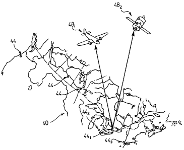
[0017] Figure 1 shows a territory 40 containing a plurality of urban regions
44. In
the example in Figure 1, territory 40 is a section of North America roughly
bisected by the
US-Canada border, but it is to be understood that this is merely an example of
a territory
-8-
CA 02627989 2011-11-07
to which the teachings herein can apply. Thus, the urban regions 44 in
territory 40
include various well-known urban regions, including Toronto, indicated at 44,s
Detroit
indicated at 442, and New York at 443 - other areas are simply indicated by
the reference
44. It should be understood that, in a present embodiment, area 44 is not
intended in its
political sense, but rather to indicate urban regions in a geographic sense.
Thus, an area
like Toronto 44, refers to the Greater Toronto Area, or the entire "Golden
Horseshoe",
spanning the municipalities from Hamilton to Bowmanville along the north shore
of Lake
Ontario. In like fashion, Detroit 442, and New York 443 refer to their
respective greater
metropolitan areas.
[0018] Figure I also shows two remote sensing devices 48, namely an airplane
48,
and a satellite 482 passing over territory 40. Devices 48 include imaging
equipment to
enable device 48 to be operable to remotely sense data associated with urban
regions 44,
according to a desired and appropriate remote sensing modality such as aerial
photography, aerial/digital orthoimagery, LIDAR, IKONOS, RADAR. Other types of
devices 48, and modalities respective thereto, will occur to those of skill in
the art.
[0019] Figure 2 shows device 48 (i.e. airplane 481) remotely sensing data
respective to a particular area 52 within a region 44 (i.e. Toronto 44)). In
general, device
48 is operable to sense data associated with a plurality of areas within a
particular region
44, thereby remotely sensing data that comprises the entire region 44. Thus,
it is to be
understood that area 52 is shown as an example for purposes of explaining
various
embodiments of the invention.
[0020] Figure 3 shows area 52 in greater detail, and in a present embodiment,
area
52 is sensed by device 48 as a photograph. Area 52 (and/or portions thereof
and/or other
portions of region 44) can be characterized in terms of a number of (nd/cia,
Including
physiographic forms, built forms, activity patterns, and use intensity, and
various degrees
thereof. Physiographic forms includes the natural physical features of area
52, including
landscape and physical objects such as terrain, trees, rivers, and streams.
More specific
terms ways of describing physiographic fonns can be found in Anderson, James
R., E.E.
Hardy, J.T. Roach, and R.E. Witmer, 1976. "A Land Use And Land Cover
Classification
System For Use With Remote Sensor Data." Geological Survey Professional Paper
964.
-9-
CA 02627989 2011-11-07
In contrast, built forms
include anything artificially constructed upon the physiographic forms, such
as roads,
houses, buildings, parks, parking lots, monuments, etc. (Table I, hereinbelow,
provides a
detailed list of potential built form types.) Activity patterns include the
nature of the
human activity/activities occurring within area 52, and can include
information about
employment, residency, recreation, industry, commerce and/or combinations
thereof.
Finally, use intensity is a metric identifying the extent or amount of a
particular activity is
occurring. Intensity can also include the degree of a particular activity, or
mix of
activities, in order to describe the possibility of a varying range to the
activity indieium of
the classification scheme. Further details about these indicia will be
discussed in greater
detail below.
[0021] Figure 4 shows a small portion of area 52 in further detail, with
device 48
passing over, and sensing physiographic forms 56, in the form of trees 56, and
a stream
562, and built forms 60, in the form of houses 601, an office tower 602, and
an apartment
building 603.
[0022] Figure 5 shows the transfer of data 64 sensed by device 48 that
includes a
photograph of area 52 being transferred from device 48 to an apparatus 68 for
mapping in
accordance with an embodiment of the invention. Apparatus 68 is generally
operable to
interpret data 64 to generate a map of area 52 that is based on, at least in
part, some or all
of the above-identified indicia. In the present embodiment, apparatus 68 is a
server, but
can be a desktop computer, client, terminal, personal digital assistant or any
other
computing device. Apparatus 68 comprises a tower 72, connected to an output
device 76
for presenting output to a user and one or more input devices 80 for receiving
input from a
user. In the present embodiment, output device 76 is a monitor, and input
devices 80
include a keyboard 801 and a mouse 802. Other output devices and input devices
will
occur to those of skill in the an. Tower 72 is also connected to a storage
device 84, such
as a hard-disc drive or redundant array of inexpensive discs ("RAID"), which
contains
reference data for use in interpreting data 64, further details of which will
be provided
below. Tower 72 typically houses at least one central processing unit ("CPU"}
coupled to
random access memory via a bus. In the present embodiment, tower 72 also
includes a
network interface card and connects to a network 88, which can be the
intranet, internet or
-10-
CA 02627989 2008-04-25
any other type of network for interconnecting a plurality of computers, as
desired.
Apparatus 68 can output maps generated by apparatus 68 to network 88 and/or
apparatus
68 can receive data, in addition to data 64, to be used to generate a map of
area 52 that is
based on, at least in part, some or all of the above-identified indicia.
[0023] Figure 6 shows a simplified representation of the kind of databases and
tables that can be stored on storage device 84 to assist the CPU in tower 72
with the
interpretation of data 64. In Figure 6, storage device 84 stores a two-
dimensional table
92. Table 92 includes built form data, comprised of a left column 96, labelled
"Raw
Data", and a right column 100, labelled "Interpretation". Thus, each record in
table 92
includes, in left column 96, an object 104 corresponding to raw data that
maybe found in
remotely sensed data 64, and in right column 100, an object 108 identifying a
corresponding interpretation of object 104. More specifically, object 104,
corresponds to
a house, object 1042 corresponds to an office tower, and object 104õ
corresponds to an
apartment building.
[0024] It is expected that the raw data found in data 64 will include a number
artefacts and other unique identifiers, and table 92 will include information
about such
identifiers to provide CPU in tower 72 with additional information to use when
distinguishing between various types of built forms found in data 64. Figure 7
shows
objects 104 in greater detail, to provide examples of the kinds of identifiers
that can be
associated with each object in table 92. For example; is to be noted that each
object 104
includes a shadow 112. Note that shadow 1122 is the longest, shadow 112õ is
shorter than
shadow 1 122 and shadow 112, is shorter than shadow 112 ,,. Such shadow length
as
found in data 64 can be used to infer the height of a given object 104, and
therefore can
assist CPU in tower 72 with inferring the type of built form that is
associated with a given
object found in data 64. By determining relative heights of objects in data
64, the CPU in
tower 72 can make relative decisions about the appropriate interpretation to
be given to a
particular object 104. In this example, a shadow 112 is used to determine the
height of a
given object, but it should be understood that more sophisticated means can be
used to
infer height - such as through the use of LIDAR. Thus, when data 64 is
collected, it can
be desired to use a combination of sensing modalities, i.e. photography and
LIDAR, and
-11-
CA 02627989 2008-04-25
to combine that sensed data to derive even further information and
identification about
objects in area 52.
[0025] It should now be understood that a variety of different identifiers can
be
used in computing operations performed by the CPU in tower 72 to further
assist in the
distinguishing of various built forms found in area 52. For example, the
presence of two
squares 116 on each end of object 104õ are indicative of the presence of
elevator shafts,
and the rectangular shape of object 104,, in combination with the presence of
the elevator
shafts and its shorter height than object 1042 can be used to determine that
object 104,, is
an apartment building. As an additional example, object 104, includes a peak
line 120 of
its roof, as further indication that object 104, is a house.
[0026] As another example of an identifier, close groupings of elements in
data 64
that resemble objects 104, can be used as a further indicator that such an
element is in fact
a house 601. As still a further example of an identifier, large open spaces
detected around
a given element found in data 64 can be indicative of parking lots, thereby
eliminating the
likelihood that a given element in data 64 is actually a house 601.
[0027] As an additional identifier, in certain geographic regions,
particularly in
North America, there is a limited number of built form types that recur. Due
to this
limited number, probability formulations can be used, in addition to the
identifiers such as
the identifiers listed above (or such other identifiers as may be determined
to be useful
from time to time), to improve the likelihood of an accurate determination of
a particular
built form type. Table I shows a list of such built form types and identifiers
that can
accompany each type that can be used in databases on storage device 84 (such
as table 92)
and in conjunction with software executing on tower 72 to actually distinguish
certain
built form types from others.
-12-
CA 02627989 2008-04-25
Table I
Built form !Xpes
Built Form Type Description And Identifiers Activity
Type
(Inferred From Built
Form Identification
Detached House Single family dwelling, Residential
commonly found in sub-urban
districts (residential
neighbourhoods).
Semi-Detached House One to four storeys, each a Residential
discreet building on a fenced
parcel. Usually ridge-roofed
Row House Or As above, but with one wall, Residential
Town House shared with another house.
Mid-rise Apartment A building consisting of joined Residential
Building single family dwellings, as above.
One to four storeys with shared
walls.
High-Rise Apartment Multiple family apartment Residential
Building building of five to eight floors,
often located (in north america)
along main streets, normally with
an elevator core and predictable
dimensions.
Low To Mid-Rise Free-standing buildings of 2 to 8 Office/
Office Building storeys, most commonly in Administration
suburban locations and main
streets. Distinguished usually by
entrance and surface parking
atterns around them.
High-Rise Office Free-standing building of 8 or Office/
Tower more storeys, identified Administration
particularly by plate dimensions
and shape.
Main Street Shop 2 to 4 storey buildings with party Retail
Building walls, characterized by relatively
narrow street frontages,
composing shopping streets.
Strip Mall Single-storey buildings arranged Retail
along or around surface parking
lots.
13-
CA 02627989 2011-11-07
Built Form Type Description And Identifiers Activity
Type
(Inferred From Built
Form Identification)
Shopping Mail A building composed of larger Retail
and smaller elements (department
stores and shops, surrounded by
surface parking and with specific
truck loading patterns.
Big Box Store Free-standing retail store of Retail
characteristic dimensions, with
surface parking adjacent.
Factory Large-plate, deep-space building Manufacturing
of one or two storeys, with
characteristic truck access and
loading patterns.
Road/Highway Long, continuous pathway that Transportation
separates other discrete built form
types.
Railway Long, continuous pathway that Transportation
separates other discrete built form
types.
[0028) Thus, once tower 72 receives data 64, it can perform a progressive ran
(or
other suitable analytical technique) thereof, parsing elements found ;n the
data 64
representing area 52, and compare those parsed elements with the information
in table 92,
particularly, the raw data left column 96 to ultimately identify the type of
built form at
that particular location in area 52. More particularly, once data 64 is parsed
and objects
therein are isolated, CPU in tower 72 can detect the presence and location of
houses 60r,
office towers 602 and apartment building 603. In general, those of skill in
the an will
recognize that the tasks being performed by CPU in tower 72 can be based on
known
techniques found in commercially available software that are currently applied
to
determining types of terrain and modelling of buildings. See for example
htip://www.tec.army.rniYTD/tvd/survey/indcx.html of the US Army Corps of
Engineers.
Those of skill in the art will now understand that such known techniques
provide
-14-
CA 02627989 2008-04-25
operations and software procedures for recognizing the presence, and showing
the
configuration of, various physiographic forms and built forms, but are not
generally
suitable, in their current form, to perform the task of identifying different
types of built
forms. (i.e. In the military context, the purpose of gathering such
information is for
gaining battlefield advantage to invade or defend an urban region, and not for
the purpose
of planning improvements to the region.)
[0029] Referring now to Figure 8, a method for generating a map is indicated
generally at 300. In order to assist in the explanation of the method, it will
be assumed
that method 300 is operated using apparatus 68 and the above-described aspects
relating
thereto. Furthermore, the following discussion of method 300 lead to further
understanding of apparatus 68. (However, it is to be understood that apparatus
68 and/or
method 300 can be varied, and need not work exactly as discussed herein in
conjunction
with each other, and that such variations are within the scope of the present
invention.)
[0030] Beginning first at step 310, remotely sensed data of an urban region is
received. This step is essentially performed as previously described, with
remote sensing
device 48 passing over a given urban region 44 and, with its imaging
technology
activated, the device 48 gathers data, such as data 64, of a particular region
44. The data
64 is then transferred to tower 72 of apparatus 68 using appropriate network
interfaces -
such as via wireless directly from the device 48, or by means of a physical
media that is
removed from device 48 and inserted into a reading device on tower 72, or by
any other
means as desired.
[0031] Next, at step 320, the remotely sensed data is parsed into objects with
location coordinates. This step can be done according to any known or desired
technique
of analyzing data 64 to extract individual objects, and assign coordinates
thereto, as will
occur to those of skill in the art. For example, Figure 9 shows area 52 in
data 64 being
divided into a logical grid 124, with an (X,Y) coordinate system, and with an
origin 128 at
the coordinates (0,0). Figure 9 also shows four squares in grid 124
highlighted as block
132. Block 132 begins at coordinate (6, 2) on grid 124. To help further
explain method
300, block 132 will be discussed in greater detail as an example of how method
300 can
process data 64.
-15-
CA 02627989 2008-04-25
[00321 Figure 10 shows block 132 of data 64 in greater detail. Thus, when step
320 is performed on block 132, image processing performed on that block 132
leads to
the identification of objects 1361i 1362, 1363 ... 1366 as labelled on Figure
10. Note that,
the manner in which objects 1361, 1362, 1363 ... 1366 are shown in block 132
is to be
representative of the appearance of objects 1361, 1362, 1363 ... 1366 of such
objects as
raw collected data by device 48, as packaged within data 64. Thus objects
1361, 1362,
1363 ... 1366 include a number of artefacts and other identifiers, but objects
1361, 1362,
1363 ... 1366 are otherwise currently unidentified. Thus, also when step 320
is performed
on block 132, a database is created that lists those objects and their
locations. Table H
shows a list of location coordinates that would be created during the
performance of step
320 on block 132.
Table II
Objects and locations in Block 132
Obiect Number Location Coordinates
MY)
Object 1361 (6.3, 3.3
Object 1362 (7.1, 3.6
Object 1363 (6.4,2.8)
Object 1364 7.7, 3.2
Object 1365 (7.3, 2.9
Object 1366 7.5, 2.3
[0033] Referring again Figure 8, method 300 advances from step 320 to step
325,
at which point the objects parsed at step 320 are compared with a set of
expected built
forms. Thus, having identified objects 1361, 1362, 1363 ... 1366, each one is
then
compared with an expected set of built forms stored in device 84, and in
particular, in
table 92. Using table 92 and the aforementioned interpretation techniques (or
such other
interpretation techniques as may be desired), an interpretation of the raw
data associated
with each object 136 can be obtained. During such a comparison, it will be
determined
that object 1361 resembles object 1042; objects 1362 resembles object 104,,;
and objects
objects 1363, 1364, 1365 and 1366 resemble object 1041.
- 16-
CA 02627989 2008-04-25
[0034] At step 330, the type of built forms of each object is determined.
Thus,
using the results of the comparison at step 325, tower 72 makes a
determination as to the
identity of each of the objects 136 identified at step 320, and adds to the
information in
Table 11 to produce a new table, of the form of Table III, that includes the
built form type
of that particular object.
Table III
Built form a of each object in block 132
Object Number Location Built form
Coordinates Type
MY)
Object 136, (6.3, 3.3 Office Tower
Object 1362 (7.1, 3.6) Apartment
Building
Object 1363 (6.4, 2.8 House
Object 1364 (7.7, 3.2 House
Object 1365 (7.3, 2.9 House
Object 1366 (7.5, 2.3 House
[0035] At step 335, a built form map is generated based on the results of the
performance of steps 320-330. Thus, tower 72 uses the information in Table III
to redraw
block 132. As shown in Figure 11, tower 72 thereby generates block 132a from
block 132
and Table M, and outputs block 132a onto output device 76. (It should be
understood hat
U'ock 132a can also be saved on storage device 84, or sent to another
computing dev;,re
on network 88, or output in other ways.) Block 132a thus represents the built
forms in
area 52 in iconographic form, and provides a legend as to the built form type
of each icon
present in block 132a. In a similar manner, tower 72 can thus present all of
area 52,
and/or all of region 44 on display 76. In a present embodiment, it is
contemplated that a
full range of navigational tools are provided, to allow a user to use input
devices 80 to
move around area 52 (or region 44), and to zoom in or zoom out as desired.
[0036] As additional step to step 335, or as a variation to step 335, block
132 can
be generated in the form shown in Figure 12, indicated as block 132b, wherein
a
-17-
CA 02627989 2008-04-25
particular square bounded by a set of coordinates on grid 124 is marked in
accordance
with the most prevalent type of building form found within that particular
square.
[0037] The methodology used to generate the map in Figure 12 can also be
applied to generation of maps of area 52 (in the form shown in Figure 13 as
area 52a)
and/or the entirety of region 44 (in the form shown in Figure 14 as region
441a. In Figure
13, area 52 has been rendered on output device 76 into area 52a, and is
divided into four
precincts 1361, 1362, ... 1364. Each precinct 136 is shaded according to the
type of built
form that is predominant in that precinct 136. Thus, precinct 1361, is shown
to consist
predominantly of office towers 602; precinct 1362 is shown to consist
predominantly of
apartment buildings 603; while precincts 1363, and 1364 are shown to consist
predominantly of houses 601. It is to be understood that other built forth
precinct types
can be included, such as hybrids of office towers 602 and houses 601, where a
given
precinct consists of more than one predominant type of built form. It is also
to be
understood that the criteria used to determine where one precinct 136 begins,
and another
ends, is not particularly limited, and can be based on any number of factors
such as user
selection, political boundaries, physiography, transportation routes,
combinations thereof,
and/or can be based on more "fuzzy" types of logic where tower 72 is
configured to create
precincts according to groupings of squares in area 52 that are characterized
by a
predominance of a particular built fonn types. It should be understood that
the particular
shapes of precincts are thus not limited, and such shapes will depend on the
criteria used
to define a precinct. As an example, in a city such as Toror_tn. Ln,iiorth
Avenue exhibits
common indicia along the stretch known as "Greektown" - this oblong stretch
could be
selected as a criteria for a particular precinct. So too, any area where a
street exhibits
common indicia such that it is desirable or logical to define that street as a
precinct. It is
also contemplated that new maps can be quickly generated based on user
inputted changes
to such criteria.
[0038] It will now be understood that where a map of the type shown in Figure
13
is generated for an entire region 44, comparisons of precincts characterized
by
predominant built form types, and distributions thereof, between different
regions 44 can
be readily compared. For example, where a map of the type in Figure 14 is
created for
Toronto 441, and another for New York 443, (not shown) a comparison can be
made of the
-18-
CA 02627989 2011-11-07
predominant built form types and their distribution throughout each respective
region 44.
It should now also be understood that the example map in Figure 14 includes a
broad
range of built form types based on the list of built form types shown in Table
1. It should
be noted, however, that the list in Table I is non-exhaustive, and that other
built forms
will now occur to those of skill in the art. For example, a semi-permanent,
single
detached, trailer is an additional type of built form not listed in Table I.
[00391 The maps shown in Figures 11-14 are primarily directed to built form.
In other
embodiments of the invention, however, maps can be generated that include
information
in addition to built form. Such maps include other lndicia that can used to be
characterize
a particular region, including physiographic forms, activity patterns, and use
Intensity.
The addition of physiographio forms is relatively straightforward using
existing remote
sensing and mapping techniques. Examples of existing commercial packages that
can
be- used as part of performing this addition of physiographic forms Include
ERDAS
imagine (from Leica Geosystems GIS & Mapping, LLC, Worldwide Headquarters,
2801
Buford Highway, N.E., Atlanta, GA 30329-2137 USA) and packages from PCI
Geomatles
(from 50 West Wilmot Street, Richmond Hilt, Ontario Canada, L48 IM5) for image
processing. The commercial packages ArcGIS (from ESRI, 380 New York Street,
.Redlands, CA 92373-8100, USA), and Mapinfon" (from Maplnfo, 26 Wellington
Street
East, Suite 500, Toronto, ON M5E 1S2) can be used for mapping.
[0040} In the previous embodiment, a cctiain degree of activity pattern was
inferable due to the process of recognizing thc; built form types - i.e. that
houses and
apartments indicate an activity of "residence", while office towers indicate
an activity
pattern of "employment". However, in other embodiments, activity patterns
and/or use
intensity is added using geospatial and/or demographic data corresponding to
the region
being mapped. Geospatial data can include information that identifies the
geographic
location and characteristics of natural or constructed features and boundaries
on the earth.
Geospatial data information may be derived from, among other things, remote
sensing,
mapping, and surveying technologies. Demographic data which can be considered
a
subset of geospatial data, and can include statistics relating births, deaths,
ages, incomes
etc. that illustrate the conditions of life in a given region 44-
-19.
CA 02627989 2008-04-25
[0041] As an example of the foregoing, in Figure 15 demographic data 140 is
input into tower 72 in conjunction with data 64 to be used in the generation
of an
enhanced map. As used herein, the sources of demographic data 140 can be multi-
fold,
to include data that is collected and maintained by government organizations,
such as
census data, taxation data, land registry data, employment surveys, and to
include data
that is collected and maintained by non-government organizations. Thus, the
means by
which demographic data 140 is actually inputted into tower 72 will depend on
the form in
which it currently exists, and with appropriate consideration to privacy laws.
Thus, as
tower 72 receives both demographic data 140 and remote sensed data 64, tower
72 will
include further functionality to correlate the physical areas in region 44
and/or area 52 that
correlate with the demographic data 140 being collected. (It should be noted
that for the
sake of privacy, readily-available census data is often aggregated to a
spatial unit, e.g.
census tract or enumeration area, rather than by address. In order to
correlate it with the
built form types, the data can be disaggregated and related to the individual
buildings. )
[0042] Thus, one significant source of demographic data 140 that can be used
to
determine activity patterns and/or intensity of use within region 44, area 52,
block 132, or
any given built form therein is census data. Census data that includes
addresses can be
correlated to the built forms detected using method 300. Census data can be
used to
determine, for example, how many individuals reside in the house identified as
object
1363 in Figure 10. In this manner, the density of the population residing
within any
precinct 136 can be d":er;nined. The precinct 136 can then be iconographically
represented as a resideniia; precinct, and in a manner that indicates the
actual density of
people living in that precinct. An example of a map outputted using this data
is shown in
Figure 16. Precinct 136a1 is indicated to have zero to ten persons per square
meter
residing in that precinct 136a1. Precinct 136a2 is indicated to have greater
than 100
persons per square meter residing in that precinct 136a2. Precincts 136a3 and
136a4 is
indicated to have ten to one-hundred persons per square meter residing in
those precincts.
It should now be understood that the type of map in Figure 16 can be expanded
to the
regional scale, and again readily permit comparisons between different regions
44 for
which maps of that type are generated. (Note that while the units of persons
per square
meter is chosen, and suitable unit can be used, such as persons per hectare,
etc.)
-20-
CA 02627989 2008-04-25
[0043] As an additional comment however, while the map in Figure 16 is
described as having been generated using demographic data 140, it can also be
possible to
infer average levels of occupancy based on the determined built form type from
Table I,
and use that inferred level to develop the map in Figure 16.
[0044] By the same token, other types of demographic data 140 can be used to
determine the number of employees working at the office tower identified as
object 136,
in Figure 10. Other types of activity patterns, intensity of uses and other
indicia to create
specific precincts will now occur to those of skill in the art. Table IV
below, however,
provides an exemplary list of activity patterns, and metrics for intensity of
use to
accompany those patterns that can be used to generate maps using the teachings
herein.
Table IV
Activity Patterns and Use Intensity
Activity Use Intensit ' Metric
Residence Average number of persons
per square meter residing
in precinct
Average number of persons
residing per cubic meter in
precinct
Employment Average number of persons
per square meter employed
in precinct
Retail Number of stores per
square meter in precinct
Transport Number of persons using
transport through corridor
per day
[0045] In general, it should now be understood that maps of regions 44 can be
generated using the teachings herein in an automated and relatively efficient
manner.
Further, it should be understood that such maps, at the regional level, can be
generated to
include a plurality of precincts, where each of those precincts is uniquely
identifiable
according to a set of trends or commonalities between a set of indicia that
can be used to
-21 -
CA 02627989 2008-04-25
characterize an urban region. Such precinct maps of regions 44 can be used for
urban
planning purposes, to compare with other urban regions, and/or in their own
right, to
determine how best to add, replace and/or maintain infrastructure in an urban
region.
Precinct maps can be generated according to a specific urban planning project
or question.
For example, if it is to be determined whether a particular region can support
a new
subway line, then a precinct map can be generated that identifies residential
precincts and
employment precincts, with the view to choosing a path for the subway line
between such
precincts provided that such precincts appear to have populations that are
able to support
the new subway line. Such precinct maps can also be used for a variety of
other planning
purposes, including airports, cell phone deployments, new highway
construction, sewage
and water treatment facilities, power line and supply requirements and the
like. Other
types of precinct maps for other types of planning purposes will now occur to
those of
skill in the art.
[0046] Referring now to Figure 17, a method for generating a map is indicated
generally at 500. Method 500 can be operated using apparatus 68 and the above-
described aspects relating thereto. It is to be understood that apparatus 68
and/or method
500 can be varied, and need not work exactly as discussed herein in
conjunction with each
other. At step 510, geographic data is received. The data can be received as
previously
described, based on satellite images, or it can be received as existing GIS
data. At step
515, the received data is parsed. The data is parsed using any technique that
corresponds
with the desired types of indicia to be presented in the final map to be
generated. One
way to parse the data is as previously described with method 300, however, "nv
tyres of
processing techniques, including known image processing and GIS processing
techniques
can be used. Next, at step 520, indicia are generated and associated with
their respective
geospatial location in the region of geographic data that was received at step
510. Any
type of indicium, or indicia or combinations thereof, can be generated,
including built
form, activity pattern, intensity of use etc,. At step 525, precinct
boundaries in the region
of geographic data received at step 510 are defined using any desired
criteria, such as the
criteria previously described. At step 530, the indicia generated at step 520
are
aggregated and overlayed onto the defined precincts boundaries to generate a
map of the
region comprised of precincts that are identified according to the particular
chosen set of
indicia.
-22-
CA 02627989 2008-04-25
[0047] It is to be reiterated that the criteria or other means used to define
a
precinct are not particularly limited. For example, Tables V - VII show an
example of
measurements that can be could be generated by apparatus 68, and/or by method
500 for
an exemplary precinct on area 52, called "Precinct 1". Precinct "1", may, for
example,
appear in a map such as the type shown in Figure 14. Table V relates to
intensity
measurements of physiography; Table VI relates to intensity measurements of
built form;
while Table VII relates to intensity measurements of activity. The values
associated with
each field in the respective table reflect an intensity level, expressed in
terms of
percentage.
Table V
Physiography and Intensity
For Precint "1"
Soil Tree Water Rock
70% 10% 10% 10%
Table VI
Built Form and Intensity
For Precint "1"
House Office Tower Apartment Road/Highway
60% 0% 15% [25%
Table VII
Activity and Intensity
For Precint "I"
Residential Commercial Residential Road Major Road
80% 0% 10% 10%
[0048] The data gathered in Tables V-VII, when tabulated by apparatus 68, can
result in a graph of the type shown in Figure 18, which is characterized as a
precinct of
-23-
CA 02627989 2008-04-25
type "A". Such characterizing of Precinct "I" as of being type "A" can be
based on
certain threshold percentages for each type/category of indicia and associated
intensity.
An example of such threshold values is shown in Table VIII.
Table VIII
Threshold values for Precincts of type "A"
Physiography Soil Tree NNIater Rock
Minimum 60%, Minimum 0% Minimum 0% Minimum 0%
Maximum 80% Maximum Maximum 10% Maximum 10%
10%
House Office Tower Apartment Road/Highway
Built Form
Minimum 50%, Minimum 0% Minimum 0% Minimum 15%
Maximum 90% Maximum Maximum 20% Maximum 40%
10%
Residential Commercial Residential Major Road
Activity Road
Minimum 70% Minimum 0% Minimum 10% Minimum 0%
Maximum 100% Maximum Maximum 20% Maximum 10%
10%
[0049] Thus, using the threshold values for a precinct of type "A", (and/or a
plurality of different precinct types) maps of different urban regions can be
generated to
locate where ti r are common precincts of type "A". Other uses for obtaining
maps that
identify precincts now occur to those of skill in the art. By the same token,
it will
now occur to those of skill in the art that any number and combinations of
different types
of indicia can be used. Furthermore, while Tables V-VIII all refer to
percentages of
intensity, it should also be understood that Tables can merely look for the
presence or
absence of a particular type of indicia.
[0050) While only specific combinations of the various features and components
of the present invention have been discussed herein, it will be apparent to
those of skill in
the art that desired subsets of the disclosed features and components and/or
alternative
combinations of these features and components can be utilized, as desired. For
example,
other means of remotely sensing data can be used - e.g. electronic survey
conducted by
-24-
CA 02627989 2008-04-25
internet, involving the distribution of a survey to individual subscribers who
own a
particular building within the region being surveyed.
[0051) It should now be apparent to those of skill in the art that the present
invention provides a novel Geographic Information System ("GIS"). It is also
to be
understood that method 300 is but one particular way of interpreting remotely
sensed data
to generate the types of maps in Figures 11, 12, 13, 14 and 16 and variations
and/or
combinations thereof, and that additional methodologies can be employed, as
desired. For
example, another approach is to first use geospatial data to segment or parse
areas in the
remotely sensed data into "manageable" units that exhibit similar
characteristics. Next,
census tracts are located in the region that have a high population density by
analyzing
that variable for the entire region using an off-the-shelf GIS. Next, if it is
assumed that
that high population densities are the result of a high built form density,
e.g. high-rise
tower or slab apartments, the RS data for those same census tracts can be
isolated and
examined. The derived built form can then be verified using other imagery data
(e.g.
aerial photography) and presented using metrics that characterize a particular
built form,
i.e. high-rise tower or slab apartments. In this instance geospatial data
informs the
remotely sensed data and is usable in the assumptions about characteristics of
built form.
In general, any geospatial feature and tabular data that can be obtained and
used to infer
built form can be employed in other embodiments of the invention.
[0052] Further, while the built form maps of Figures 13 and 14 are one type of
output that can be generated using the present invention, it should now also
bd uui,derstood
that determined built forms can also be used to infer certain activities,
and/or intensities
thereof, and/or other indicia used to generate other types precinct maps for
region 44.
[0053] In a further embodiment of the invention, maps of type shown in Figures
11, 12, 13, 14 and 16, and other maps showing other indicia, can be generated
for a given
period of time, and then "played back" to the viewer to show an animation of
change over
time of a particular region, or portion thereof.
[0054] Another particular embodiment of the present invention is the
standardization of measurements used to create precincts for multiple regions
44, so that
ready comparisons can be made between different regions 44. The measurements
used to
-25-
CA 02627989 2008-04-25
identify any particular precinct can be based on any one or more of the
indicia of
physiographics, built form, activity patterns, etc. and/or intensities and/or
combinations
thereof, in conjunction with area, volume or other geographic metrics of a
particular
region. For example, a measurement can include a ratio of one type of an
activity pattern
to another type of activity pattern for a give area.
[0055] The teachings herein can have a broad range of applications, in
particular
for use in urban planning and commercial applications. For example:
1. Standardized maps can be provided of the indicia associated with
different regions. These can be useful to urban specialists and to the
general public, in providing an understanding.
2. Comparisons between these regions can be readily performed due to
the standardized approach to create such maps.
3. Growth patterns of a particular region can be recognized through the
identification at regular intervals of the extent and classification of new
precincts and of changes in established areas (with regard to built form,
activities and intensities).
4. Strategic investment decisions can be made for an urban regions - in
office, retail or residential development, or in land, or for house or
other built form purchases
5. Measuring the densities of development, both gross and net, and in
particular for measuring new development.
6. Identification of opportunities across a region for urban intensification
can be performed. For example, by identifying vacant or underused
lands around subway or light-rail stations.
7. As a means of assessing effects of new investments in infrastructure
(e.g. a rail line) or a sectoral investment (such as a "big box" retail
centre).
-26-
CA 02627989 2008-04-25
8. At the urban regional level, the embodiments herein can be used as a
basis and tool for constructing consistent, comprehensive and
sufficiently informative regional growth plans for infrastructural
investments (public transport, roads, sewerage, water, etc.) and the
necessary accompanying strategies for the deployment of buildings and
activities. An example of the importance of this understanding is that
the United States government has recently begun to require of all urban
regions that they have regional strategies that promote increased
reliance on public transportation if they are to receive allocations from
the Highway Fund for capital transportation purposes. This requires a
region to obtain regional understandings of its component precincts,
activities and movement patterns, and the present and anticipated
intensities. Thus, the teachings herein can be incorporated into broader
methodologies used to perform actual urban planning and as part of
formulas used to calculate government grant allocations.
[0056] The present invention provides a novel system and method for mapping.
The maps generated according to the teachings herein provide frameworks to
understand,
at the regional scale, the existing patterns and trends of built form and
activities, and their
intensity; and the patterns of communications. Since, in these respects, urban
regions
vary greatly, prior art technique do not allow for ready comparisons of
different urban
regions. For example, the Ranstadt region (composed of Amsterdam, Rotterdam,
the
Hague and other cities) is poly-nuclear. The London region is highly
concentric. The
Pearl River Delta (probably the world's largest urban region) tends to be a
carpet of
highly mixed activity, with several highly compact and intensive nodes (Hong
Kong,
Shenzhen, Guangzhou, Zhuhai). Again, Toronto has an unusually compact centre
and
low-density suburban periphery, a pattern that appears to be in the process of
reinforcement with very low density exurban extensions and a great wave of
central urban
intensification. Toronto, like virtually all North American urban regions has,
in the past
four decades, experienced an explosion of suburban office space, most of it
located in a
large number of small and moderately-sized low density clusters along major
highways
and freeways. In North American urban regions this kind of office sprawl now
constitutes, more or less, half of the regional office space. The present
invention
-27-
CA 02627989 2008-04-25
provides a novel system and method for generating maps to understand the
aforementioned conditions and patterns. Maps generated using the teachings
herein can
be provided that allow ready comparisons between different regions, on a
consistent,
comprehensive, efficient and/or low cost basis. This is generally not possible
using prior
art mapping techniques of in urban regions, nor is it possible to provide a
level of
information that provides a ready and proper basis for land use/transport
policy and
program formulation.
[0057] The above-described embodiments of the invention are intended to be
examples of the present invention and alterations and modifications may be
effected
thereto, by those of skill in the art, without departing from the scope of the
invention
which is defined solely by the claims appended hereto.
-28-