Note: Descriptions are shown in the official language in which they were submitted.
CA 02628657 2008-04-08
LANDMARK NAVIGATION FOR VEHICLES USING BLINKING OPTICAL
BEACONS
BACKGROUND OF THE INVENTION
The present invention is directed to positioning and navigation systems.
Positioning and navigation systems are used in a wide range of applications.
One
particular application that presents unique challenges is in connection with
robots or unmanned
vehicles. Currently, a global positioning system (GPS) is virtually the only
technique used for
robot positioning in outdoor applications. Developments in this field have
been made to
accommodate the accuracy and limitations of GPS. When GPS capability is denied
due to signal
reception difficulties, then these devices turn to inertial navigation system
(INS) techniques. A
GPS/INS positioning system is expensive and achieves precise navigation only
when a
significant view of the GPS satellites exists from time to time. Moreover, it
is still necessary to
employ a source of differential GPS correction data from a radio transmitter
station in
communication with the vehicle. Furthermore, INS systems accrue error as a
function of time
because they use acceleration sensors to calculate position displacement
through integration.
Therefore, every minute that a GPS/INS-based system does not see enough sky to
cancel out the
INS error, the position accuracy of the vehicle continues to worsen.
Dead reckoning is a technique used to update position during periods of
"blackout" of the
absolute positioning system (e.g., GPS). This may be achieved by sensing the
relative movement
of the vehicle as it moves about. INS techniques may be used to determine
relative movement,
but odometry is often used instead of INS for dead reckoning. The sources of
error with
odometry are the uncertainty in the direction of motion at any instant and
slippage of the
vehicle's wheels on the terrain. Dead reckoning error is commonly specified as
percent error
versus distance traveled and two percent dead reckoning error is considered
very good. Thus, for
applications that require very precise positioning determinations, it is not
tolerable to have
blackouts in the absolute positioning system.
Numerous positioning system approaches are known that attempt to provide
accurate
mobile robot positioning without the use of GPS. These approaches include GPS-
pseudolite
transmitters, RF beacons, ultrasonic positioning, active beam scanning and
landmark navigation.
In particular, a landmark navigation system uses a sensor, usually a camera,
to determine a
CA 02628657 2008-04-08
vehicle's position and orientation with respect to artificial or natural
landmarks. Artificial
landmarks may be deployed at known locations and in current systems heretofore
known take the
form of a high contrast bar code or dot pattern. A sensor device can observe
both the orientation
and distance to the landmark so that only two landmarks need to be viewed in
order to compute
the vehicle's position. The challenge in a landmark navigation system is in
reliably identifying
the landmarks in cluttered scenes. The accuracy of the position computation is
dependent on
accurately determining the camera orientation to the landmark. Also,
sufficient illumination is
necessary with existing landmark navigation solutions.
Nevertheless, landmark navigation is attractive because of its potential for
accuracy, high
reliability, low cost and relative ease of deployment. There is, therefore, a
need for an improved
landmark navigation positioning system that can achieve the reliability and
accuracy that current
positioning system solutions for robotic or unmanned vehicles cannot.
SUMMARY OF THE INVENTION
Briefly, the present invention is directed to a system and method for landmark
navigation
that is much less expensive and complex to deploy than systems heretofore
known. According
to the present invention, optical beacons are deployed at locations throughout
a field of operation
of a vehicle. The optical beacons emit or reflect an optical signal at a
predetermined blink
frequency. The locations of the optical beacons may or may not be known to the
vehicle.
There is at least one imaging device on the vehicle, such as a digital camera,
to capture
images in the field of operation, and in particular a pair of image frames
such that the time
interval between the image frames of the pair is equal to one-half of the
blink period of the
optical signal. Data is generated that represents a difference frame between
two image frames
captured by the imaging device. Pixel locations of optical beacons in the
difference frame are
identified. The position and orientation of the vehicle is determined from
data representing pixel
locations of optical beacons in the difference frame.
When positions for one or more optical beacons are known, data representing
those
positions are stored in the vehicle and used to match or associate pixel
locations of beacons to
actual optical beacons for purposes of the position and orientation
computations. However, the
position of an optical beacon may be self-surveyed and thus determined by the
vehicle using data
2
I
CA 02628657 2012-08-15
accumulated over time for views of the optical beacon captured by the vehicle
at different
locations in the field of operation. The vehicle may have other positioning
systems that it can
use to determine its position or orientation in the field of operation, and
thus the optical beacon
positioning techniques of the present invention may augment those other
positioning systems.
In accordance with one aspect of the present invention, there is provided a
method for
landmark navigation of a vehicle, comprising a. storing data in the vehicle
representing locations
of each of a plurality of optical beacons in a field of operation, wherein
each optical beacon
emits or reflects an optical signal at a predetermined blink frequency and
with a 50% duty cycle
and such that the plurality of optical beacons are not synchronized and are
substantially out of
phase, b. during a position update cycle: i. capturing a pair of image frames
in the field of
operation with at least one imaging device on the vehicle, wherein capturing
comprises capturing
the pair of image frames such that a time interval separating the capture of
the image frames in
the pair is equal to one-half of a blink period corresponding to the
predetermined blink frequency
of the optical beacons, ii. generating data representing a difference frame
between the two image
frames in the pair of image frames, iii. identifying pixel locations of
optical beacons in the
difference frame, and iv. deriving a position and orientation of the vehicle
from data representing
pixel locations of optical beacons in the difference frame and from the stored
data representing
the location of each of the optical beacons in the field of operation.
In accordance with another aspect of the present invention, there is provided
a landmark
navigation system for a vehicle, comprising a. a data storage device that
stores data representing
a location of each of a plurality of optical beacons in a field of operation,
wherein each optical
beacon emits or reflects an optical signal at a predetermined blink frequency
and with a 50%
duty cycle and such that the plurality of optical beacons are not synchronized
and are
substantially out of phase, b. at least one imaging device that captures
images in a field of view
from the vehicle in the field of operation, and c. a controller connected to
the storage device and
the at least one imaging device, wherein for each of a plurality of position
update cycles, the
controller controls the at least one imaging device to capture a pair of image
frames such that a
time interval separating the capture of the image frames in the pair is equal
to one-half of a blink
period corresponding to the predetermined blink frequency of the optical
beacons, processes
image data for the pair of images frames to generate a difference frame
between the two image
3
I
CA 02628657 2012-08-15
frames in the pair of image frames, and analyzes the difference frame in order
to derive a
position and orientation of the vehicle based on the stored data representing
the location of each
of the optical beacons in the field of operation.
In accordance with a further aspect of the present invention, there is
provided a method
for determining a position of the vehicle based on an optical signal having a
predetermined blink
frequency and with a 50% duty cycle that is emitted or reflected by each of a
plurality of optical
beacons positioned in a field of operation of the vehicle and such that the
plurality of optical
beacons are not synchronized and are substantially out of phase, comprising
storing data in the
vehicle that represents the actual location of one or more of the optical
beacons in the field of
operation, generating data representing a difference frame between two image
frames captured
from the vehicle such that a time interval separating the capture of the two
image frames is equal
to one-half of a blink period of the optical signal, identifying pixel
locations of optical beacons in
the difference frame, and computing a position and orientation of the vehicle
and from the stored
data and from data representing pixel locations of optical beacons in the
difference frame.
In accordance with yet a further aspect of the present invention, there is
provided a
tangible computer readable medium storing instructions that, when executed by
a computer,
cause the computer to determine a position of the vehicle based on an optical
signal having a
predetermined blink frequency and with a 50% duty cycle that is emitted or
reflected by each of
a plurality of optical beacons positioned in a field of operation of the
vehicle and such that the
plurality of optical beacons are not synchronized and are substantially out of
phase, the
instructions cause the computer to perform operations comprising storing data
in the vehicle that
represents the actual location of one or more of the optical beacons in the
field of operation,
generating data representing a difference frame between two image frames
captured from the
vehicle such that a time interval separating the capture of the two image
frames is equal to one-
half of a blink period of the optical signal, identifying pixel locations of
optical beacons in the
difference frame, and computing a position and orientation of the vehicle and
from the stored
data and from data representing pixel locations of optical beacons in the
difference frame.
3a
1
CA 02628657 2012-08-15
,
BRIEF DESCRIPTION OF THE DRAWINGS
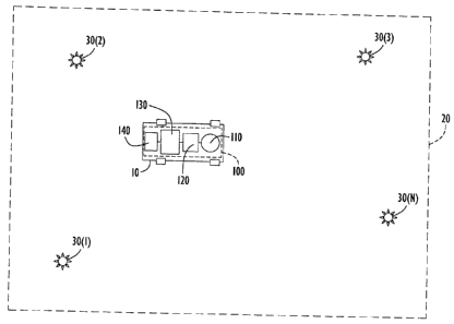
FIG. 1 is diagram showing a vehicle within a field of operation in which
optical beacons
are placed for the landmark navigation according to the embodiments of the
present invention.
FIG. 2 is a block diagram of the components on a vehicle that performs the
landmark
navigation techniques according to one embodiment of the present invention.
FIG. 3 illustrates timing of optical signals emitted or reflected by optical
beacons in
accordance with embodiments of the present invention.
FIG. 4 is a bock diagram of the vehicle components according to an embodiment
of the
present invention involving the use of passive optical beacons.
FIG. 5 is a flow chart of the positioning methodology according to an
embodiment of the
present invention.
FIGs. 6A and 6B are image frames that are captured by an imaging device on the
vehicle
and are provided for purposes of explanation operation of the navigation
methodology of the
present invention.
FIG. 7 is an image frame derived from a difference frame generated from the
image
frames shown in FIGs. 6A and 6B, and showing pixels corresponding to the
optical beacons
captured by an imaging device on the vehicle.
FIG. 8 is a schematic diagram illustrating the meaning of the pixels shown in
FIG. 7
according to the present invention.
FIG. 9 illustrates the associations or matches assigned to the beacon pixels
shown in FIG.
7 according to the techniques of the present invention.
FIG. 10 is a schematic diagram illustrating how beacon positions can be
tracked over
successive position update cycles.
3b
CA 02628657 2008-04-08
FIG. 11 is a schematic diagram illustrating a self-surveying feature for
beacons that are
new or not otherwise represented by data stored in the vehicle, according to
still another
embodiment of the present invention.
DETAILED DESCRIPTION
Referring first to FIG. 1, a vehicle is shown at reference numeral 10 that
moves about
within a field of operation shown at reference numeral 20. The vehicle may be
a robotic self-
controlled vehicle, or a remotely controlled vehicle, or any other vehicle on
which it is desired to
have navigation capabilities. The field of operation 20 may be a room inside a
building, an
entire building, an outdoor region such as a town or city, etc. Positioned
throughout the field of
operation 20 are optical beacons 30(1) to 30(N). In one embodiment, the
positions or locations
of the optical beacons 30(1) to 30(N) are known a priori or otherwise
determined prior to
deployment of a vehicle 20 in the field of operation. In another embodiment,
the vehicle 20
determines the positions of the optical beacons by way of a self-surveying
technique described
hereinafter. The optical beacons may be positioned on the ceiling of a room or
building or on a
vertical structure (e.g., wall) for indoor applications. For outdoor
applications, the optical
beacons may be positioned on vertical structures such as exterior building
walls, or other vertical
structures. The optical beacons 30(1) to 30(N) either emit or reflect light at
a predetermined
blink frequency, as described in further detail hereinafter in conjunction
with FIG. 3.
Turning to FIG. 2 with continued reference to FIG. 1, the vehicle-mounted
system
comprises at least one imaging sub-system (e.g., camera) 110, an image
acquisition sub-system
120, a positioning sub-system 130 and a navigation sub-system 140. In
addition, the system 100
may comprise other positioning equipment or components shown at 150, such as a
global
positioning system (GPS) receiver, an inertial navigation system (INS)
positioning device, light
direction and ranging (LIDAR) sensor, etc. Data storage memory units 122 and
132 are
provided for use by the image acquisition sub-system and the positioning sub-
system,
respectively. The image acquisition sub-system 120 and the positioning sub-
system 130 may be
separate units, each comprising a data processing component such as a
computer,
microprocessor, application specific integrated circuit, etc., that executes
signal processing
algorithms embodied by computer program instructions stored in a computer
readable medium,
4
CA 02628657 2008-04-08
or embodied by firmware as the case may be. The memory 122 is for storing
image data
obtained by the imaging sub-system 110 and as working memory for the
processing functions of
the image acquisition sub-system 120. Similarly, the memory 132 is for storing
position data for
the plurality of optical beacons 30(1) to 30(N), as well as data for the blink
frequency (or period)
of the optical beacons. The memory 132 is also used as a working memory for
storing data used
in the position computations described hereinafter.
It should be understood that functions of the image sub-system 120 and
positioning sub-
system 130 may be performed by a single data computing, processing or
controller unit.
Likewise, the memories 122 and 132 may be a single memory unit for storing
image data,
beacon light source position data, and other working data in connection with
the position
computations that are described hereinafter.
The imaging sub-system 110 comprises one or more imaging devices, e.g.,
digital
cameras, 112(1) to 112(M). The cameras 112(1) to 112(M) may be mounted in a
fixed
orientation on the vehicle or can be mounted on an actively stewing structure.
The positioning
sub-system 130 is programmed with the orientation, relative to the vehicle, of
the cameras 112(1)
to 112(M). For actively slewing cameras, the positioning sub-system is
programmed with the
range of motion of the camera and is supplied with a signal from the slewing
mechanism to
allow the positioning sub-system 130 to track the orientation of each camera
relative to the
vehicle at the instants image frames are obtained. When using a slewing
camera, it is desirable
to have the slew mechanism pause during the frame acquisition intervals.
The field of view of the cameras 112(1) to 112(M) are aligned to see as many
optical
beacons as possible at any one moment because a better position calculation
can be made when
data for more optical beacons are captured in the image frames. When, for
example, the field of
operation is indoors and it is known that the optical beacons are positioned
on the ceilings of an
indoor structure, one or two conventional digital cameras with a relatively
wide field-of-view
lens (e.g., 60 degrees) oriented upwards is sufficient. When the optical
beacons are positioned
on vertical structures (in an indoor or outdoor application), then six
cameras, each with a 60
degree field-of-view, provides a full 360 degree view so as to capture all
optical beacons.
Alternatively, three cameras each having a 180 degree field of view may be
sufficient as well.
Still another alternative is to use a single camera with a 360 degree
panoramic lens, wherein
5
CA 02628657 2008-04-08
software in the image acquisition sub-system 120 is provided to map out the
distortion of a
panoramic lens. For example, Sony Corporation has developed a camera module
that uses a
3600 full-circle lens and has a built-in panorama expansion processing
function.
The image acquisition sub-system 120 controls the timing of the image
acquisition by the
imaging sub-system 110 so that each camera captures a pair of image frames
separated in time
from each other by a time interval that is precisely one-half of the blinking
period of light
emitted or reflected by the optical beacons. The image acquisition sub-system
120 stores the
digital data for pairs of image frames, and as described hereinafter, computes
a difference image
between the frames in each pair, in order to identify from the digital pixel
data pixels
corresponding to optical beacons. The pixel data for identified optical
beacons in the difference
frame is supplied to the positioning sub-system 130 for use in the position
computations
described hereinafter.
The positioning sub-system 130 computes the position and orientation of the
vehicle at
each position update cycle based on the pixel data for identified optical
beacons in difference
frames. The positioning sub-system 130 supplies the position data to a
navigation sub-system
140 that uses the position information to generate velocity and direction
controls to the vehicle's
motor and steering mechanisms.
Turning to FIG. 3, the optical beacons are described in more detail. FIG. 3
shows two
optical beacons 30(1) and 30(2) and the timing of light emitted by them.
Beacons 30(1) and
30(2) are active beacons because they contain the light source that emits
light to be detected by a
camera on the vehicle. In one embodiment, each optical beacon comprises a
light source that
blinks at the same frequency (f= 1/T, where T is the blink period) with a 50%
duty cycle. The
light sources across optical beacons need not be synchronized as shown in FIG.
3, nor is it
necessary to calibrate the power of the light sources of the optical beacons.
In one example, the
frequency f of the light sources of the optical beacons is 10 Hz. The light
source may be any
light source that can be operated to blink at a controlled frequency. The
light produced by the
beacon sources needs to be detectable by the cameras used in the imaging sub-
system. For
example, and not by way of limitation, the light sources may be infra-red
light emitting diodes
(LEDs) that produce infra-red light that is invisible to the naked eye of a
human. Power for the
6
CA 02628657 2008-04-08
, .
light sources of the optical beacons may be from a battery, a solar panel and
storage cell or
conventional wall power supply obtained from a building or structure.
Beacon 30(1) is at a known position defined by coordinates (xa, Ya, za) and
beacon 30(2)
is at a known positioned defined by coordinates (xb, Yb, Zb). As mentioned
above, data
describing the position of each of the optical beacons in the field of
operation are stored in the
vehicle in what may be referred to herein as a beacon database.
In another embodiment, the optical beacons are passive beacons and one or more
light
sources are mounted on the vehicle itself to illuminate the optical beacons.
This embodiment is
now described in connection with FIG. 4. Passive optical beacons shown at
40(1) to 40(N) are
deployed as the optical beacons instead of the active blinking optical beacons
30(1) to 30(N)
shown in FIG 1. In this case, the vehicle has a blinking light source (visible
or invisible to
humans) that illuminates the reflector beacons. For example, each camera
112(1) to 112(M) may
have a dedicated light source 114(1) to 114(M). Each light source may have an
illumination
pattern that matches the field-of-view of the corresponding camera. However,
this is not
required and multiple cameras may operate with respect to the same light
source. All other
components and functions of the system and method described above are the
same.
Each vehicle-based light source 114(M) to 114(M) blinks at a fixed frequency
and with a
50% duty cycle as shown in FIG. 3. The light sources 114(1) to 114(M) may be
on continuously
to emit the blinking light into the field of operation, or they be activated
only when needed
shortly and through a position update cycle. The passive optical beacons may
employ standard
passive "corner" reflector technology. As is known in the art, a corner
reflector (also known as a
"corner cube") is a retroreflector (returns light to the source regardless of
angle of incidence)
consisting of three mutually perpendicular, intersecting flat surfaces that
reflects electromagnetic
waves back towards the source. An advantage of this alternative is that the
beacons are merely
mechanical structures that do not require power or electronics. Moreover,
since some structures
in the field of operation may serve as inherent reflector devices, it may be
possible to use those
existing structures (whose locations are known or can easily be determined) as
reflector beacons.
Turning to FIG. 5, a process 300 for deriving the vehicle position (performed
by the
components shown in FIG 2 that are on or in the vehicle) is now described. The
process 300 is
the same whether active optical beacons or passive optical beacons, or a
combination, are used.
7
CA 02628657 2008-04-08
, .
The process 300 is performed at each position update cycle, and begins at 302.
At 310, each
camera is controlled to obtained a pair of image frames, where the image
frames are captured
with a time interval separated them that is exactly one-half the blink period
T. This ensures that
one frame will be acquired while a given light source (of an active optical
beacon or on the
vehicle incident on a passive optical beacon) is on and the other frame will
be acquired while a
given light source is off. Moreover, if multiple cameras are used, then all of
the cameras are
synchronized as to when they are triggered to capture an image. At 312, the
instants in time that
each image frame (in the pair of image frames) is acquired by each camera are
recorded by the
image acquisition sub-system according to its own clock. FIGs. 6A and 68
illustrate two
exemplary images acquired by a camera, separated in time by exactly one-half
the blink period T,
where some beacon light sources are captured in each image frame of the pair.
For example, the
image frame in FIG 6A captured beacon light sources 30(1), 30(3) and 30(N),
and the image
frame in FIG 6B captured beacon light sources 30(2) and 30(4).
Next, at 320, the image acquisition sub-system generates a "difference" frame
by
subtracting one image frame from the other image frame to thereby produce an
image frame that
contains pixels corresponding to only the optical beacons (above some
threshold to account for
background noise). In addition, in order to account for possible motion
occurring between the
two image frames of a pair, image decimation may be employed to set groups of
pixels to
maximum values. Such a technique can help overcome the slight misalignment of
the two
images by insuring that the brighter, non-beacon features in the images
overlap and thus are
eliminated during the two-frame subtraction. Alternatively, imaging may be
performed when the
vehicle is stationary. Still another alternative is to use a very fast blink
frequency or to perform
imaging along the axis of motion of the vehicle. An optical frequency filter
on the camera lens
tuned to the optical frequency of the light source may have the additional
benefit of reducing
motion edge effects.
At 322, the difference frame is analyzed to identify pixel locations of
optical beacons
(active or passive) using image thresholding, such as binary thresholding well
known in the art.
FIG 7 illustrates a binary threshold image derived from the result of
subtracting one of the image
frames shown in FIGs. 6A and 6B from the other image frame. The dots 324 shown
in FIG 7
are the beacon image pixels that correspond to light sources 30(1) to 30(N) in
the field of view
8
CA 02628657 2008-04-08
= .
shown in FIGs. 6A and 6B. If multiple cameras are used on the vehicle, then
the pixel locations
of beacons in each of the resulting difference frames are identified.
FIG 8 illustrates the meaning of the pixel data derived from the images
captured by two
cameras, camera A and camera B, mounted on a vehicle. Camera A has an angular
field-of-view
(FOV)-A and camera B has an angular FOV-B. Optical beacon 30(2) is within the
FOV of
camera A and as a result when camera A is triggered to capture images, optical
beacon 30(2) will
produce an image pixel in the image plane (IP)-A for camera A. Similarly,
optical beacon 30(1)
is within the FOV of camera B and when camera B is triggered to capture
images, optical beacon
30(1) will produce an image pixel in the image plane IP-B for camera B.
Turning back to FIG 5, next at 330, the beacon pixel locations derived from
the
difference frame are associated or matched to actual beacons in the beacon
database according to
the closest (tracked) beacons for previous "difference" frames. That is,
beacon pixel positions
from prior difference frames have already been associated with an actual
beacon in the beacon
database. At 330 first beacon match data is generated that represents the
associations that can be
made based on closest beacons from difference frames at previous position
update cycles. FIG. 9
illustrates numeric identifiers being associated or assigned to each beacon
pixel in the difference
frame shown in FIG 7. As long as the beacon pixels for a current position
update cycle are at
only slightly different positions than the positions of beacon pixels for a
previous update cycle,
then they may easily be associated to actual beacons by virtue of the beacon
associations made at
the prior update cycle. However, when the first difference frame is analyzed,
it will not be
possible to associate beacon pixels to actual beacons based on prior update
cycles.
When a beacon pixel location cannot be associated with an actual beacon pixel
from
associations made at prior update cycles (because the beacon pixel locations
are too far from
beacon pixel locations at prior update cycles or because it is the first
position update cycle), then
at 340, three-dimensional ray intersection techniques are used to associate
the beacon pixel
location with a beacon in the beacon database. Reference is now made to FIG.
10 for an
illustration of the computation at 340. In this case, an unassociated beacon
pixel is produced on
the IP of a camera. Based on the pixel location of the unassociated beacon
pixel, the
unassociated beacon image pixel is associated to beacon light source 30(i)
because the beacon
image pixel is determined to be close to a computed theoretical position in
the image plane given
9
CA 02628657 2008-04-08
=
. = .
the approximate vehicle position (from prior update cycles or from the
navigation sub-system),
camera orientation and position of beacon 30(1) in the beacon database. At
340, second beacon
match data is generated that represents the associations made for those pixel
locations that are
matched using the three-dimensional pixel to beacon ray intersection
technique.
Referring back to FIG 5, next at 350, the position and orientation of the
vehicle are
computed for the current position update cycle. Since the position and
orientation of each
camera relative to the position and orientation of the vehicle are known, a
single solution for the
position and orientation of the vehicle will have associated with it a sum of
errors between (a)
the observed image pixel rays (derived from the beacon pixel positions) and
(b) the theoretical
rays derived from the calculated camera positions and orientation to the
locations of the beacons
stored in the beacon database. Thus, by minimizing this error, it is possible
to compute an
estimated position and orientation of the vehicle. For example, a least
squares fit solution
minimizes this error according to the minimum summation of squared deviations
between rays
(or alternatively, deviations between pixel locations on the image plane).
Association of the
observed beacon orientations with their actual surveyed locations stored in
the beacon database
allows the position of the vehicle to be calculated through standard
triangulation and the dead
reckoning error to be reset to zero. Thus, in essence, the vehicle position
and orientation is
derived from the first beacon match data (produced at 330) and the second
beacon match data
(produced at 340). Only two beacons need to be identified in order to
triangulate the vehicle's
position, but additional beacon observations increase the accuracy of the
computation.
At 360, the current velocity is calculated based on the position computation
made in 350,
the position at a prior position update cycle and the duration between
position update cycles.
Velocity is computed in terms of ground speed and direction. The velocity may
be "smoothed"
similar to GPS computations by average over recent position changes of the
vehicle.
At 370, the updated vehicle position and velocity, together with the frame-
pair time for
the position update cycle, are sent to the navigation sub-system in the
vehicle.
At 380, an optional self-survey function may be performed. Reference is now
also made
to FIG. 11. It is possible that beacons may be placed in the field of
operation after the device is
already deployed such that the information on one or more beacons is not
contained in the
beacon database stored in the vehicle. In this case, when a beacon pixel is
identified but cannot
CA 02628657 2008-04-08
be matched or associated with beacon pixel data for difference frames for
prior position update
cycles (at 330) and cannot be matched to data in the beacon database (340),
then data for such an
completely unassociated beacon pixel is stored. After the position and
orientation for the update
cycle in which a completely unassociated beacon pixel is found, an
intersection ray is calculated
and stored. Over time, that is, accumulated over multiple position update
cycles, data for
multiple unassociated beacon rays derived from images captured at multiple
different positions
and orientations of the vehicle are compared with each other to determine if
several beacon rays
are pointing to the same position in space according to the triangulation of
multiple beacon rays
that were recorded from significantly different view angles, even though that
point in space does
not match with a beacon in the beacon database. If so, then data is added to
the beacon database
for any new self-surveyed beacons from a position derived from the
unassociated beacon rays
and the position and orientation of the vehicle when those unassociated beach
rays were
computed and stored. In this way, new beacons can be self-surveyed by the
vehicle.
Thus, if the self-survey function shown at 380 is employed, it is not
necessary to survey-
in the position of the beacons. That is, a vehicle may be initialized in a
field of operation with an
arbitrary starting position or a position that is determined by other means
(e.g., GPS), and the
beacons in the field of operation can be self-surveyed thereafter. As the
vehicle moves about,
new beacons will come into the vehicle's field-of-view and those beacons can
then be self-
surveyed as well. Thus, a few beacons can be rapidly deployed and then the
vehicle can self-
survey other beacons that are "dropped" into the field of operation after the
vehicle is in the field
of operation. For example, a vehicle (robot) may be air-dropped into a hostile
or inaccessible
territory, use GPS for initial position determination and then use the
recently dropped beacons for
precise navigation outside of reception coverage of GPS satellites.
The functions shown at 302 through 370 (and optionally 380) are repeated at
each
position update cycle.
The system and method of the present invention provides for an inexpensive
navigation
system for indoor and outdoor applications. The positioning system need not be
integrated with
the vehicle's navigation sub-system so that the vehicle can be totally
autonomous.
As indicated above, the system and method can work with other navigational
systems,
such as GPS, by fusing its positioning data with GPS positioning data. Dead
reckoning can be
11
CA 02628657 2008-04-08
achieved between landmark observations using odometry, inertial navigation
systems, or any
other technique that can calculate relative motion. Location position sensing
and obstacle
avoidance may be implemented concurrently using conventional machine vision
and LIDAR
sensor, for example.
The applications for the system and method according to the present invention
are any
application for which vehicles, such as robots, are used, including but not
limited to line of office
or hospital delivery robots, home assistance to elderly or handicapped,
landscape maintenance,
farming, mining, construction as well as military applications. Vehicles that
use the techniques
described herein can perform missions that require sub 6-inch positioning
accuracy indoors,
outdoors in cities, in forests, near structures, inside partially enclosed
stadiums, caves, and other
situations where a GPS-based solution is ineffective.
Still another example involves cave navigation. In cave navigation, a robotic
vehicle may
deploy landmark beacons of the type described herein as it moves into the cave
and then surveys
the beacons as it moves away from them. Alternatively, two robotic vehicles
working in tandem
can reuse the beacons as they proceed through long tunnel systems. One robotic
vehicle may
carry the light beacons and the other may carry a video-based survey system,
and where the two
robots do not move at the same time. In a dark cave, visible, non-blinking
light beacons may be
used such that the image frame subtraction method may not be necessary.
Still another variation is to determine the range (and position) of the
landmark beacons
with a sensor, such as a LIDAR sensor, in order to more accurate triangulation
position
computations. Once the orientation to each beacon is determined, a ranging
sensor could be
directed at the landmark beacon. The beacon landmarks may be integrated with a
reflective
target to facilitate a ranging technique such as LIDAR.
The system and methods described herein may be embodied in other specific
forms
without departing from the spirit or essential characteristics thereof. The
foregoing embodiments
are therefore to be considered in all respects illustrative and not meant to
be limiting.
12