Language selection

Search

Patent 2632687 Summary

Third-party information liability

Some of the information on this Web page has been provided by external sources. The Government of Canada is not responsible for the accuracy, reliability or currency of the information supplied by external sources. Users wishing to rely upon this information should consult directly with the source of the information. Content provided by external sources is not subject to official languages, privacy and accessibility requirements.

Claims and Abstract availability

Any discrepancies in the text and image of the Claims and Abstract are due to differing posting times. Text of the Claims and Abstract are posted:

  • At the time the application is open to public inspection;
  • At the time of issue of the patent (grant).
(12) Patent: (11) CA 2632687
(54) English Title: METHOD AND APPARATUS FOR INVESTIGATING A BOREHOLE WITH A CALIPER
(54) French Title: PROCEDE ET APPAREIL DESTINES A INSPECTER UN TROU DE FORAGE A L'AIDE D'UN CALIBRE
Status: Granted
Bibliographic Data
(51) International Patent Classification (IPC):
  • E21B 47/08 (2012.01)
(72) Inventors :
  • HAYES, JOHN A. (United States of America)
(73) Owners :
  • LOADTEST, INC. (United States of America)
(71) Applicants :
  • LOADTEST, INC. (United States of America)
(74) Agent: MBM INTELLECTUAL PROPERTY AGENCY
(74) Associate agent:
(45) Issued: 2014-07-08
(86) PCT Filing Date: 2006-12-18
(87) Open to Public Inspection: 2007-07-05
Examination requested: 2011-07-11
Availability of licence: N/A
(25) Language of filing: English

Patent Cooperation Treaty (PCT): Yes
(86) PCT Filing Number: PCT/US2006/048549
(87) International Publication Number: WO2007/075756
(85) National Entry: 2008-06-06

(30) Application Priority Data:
Application No. Country/Territory Date
60/751,361 United States of America 2005-12-16

Abstracts

English Abstract


An apparatus for investigating a formation, comprises a caliper provided with
a transmitter for transmitting a transmitted pulse signal; a detector for
detecting a reflected pulse signal, wherein the reflected pulse signal is the
transmitted pulse signal reflected from a target location on a surface of the
formation onto which the transmitted pulse signal is incident; a means for
determining the time interval between the transmission of the transmitted
pulse signal and the detection of the reflected pulse signal; a means for
rotating the transmitter and the detector with respect to the axis of the
caliper, wherein rotation of the transmitter and the detector causes the
target location on the surface of the formation onto which the transmitted
pulse signal is incident to rotate with respect to the axis of the caliper. A
corresponding method is also disclosed.


French Abstract

Les modes de réalisation de la présente invention concernent un calibre ainsi qu~un procédé permettant de cartographier les dimensions et la topographie d~une formation telle la paroi latérale d~un trou de forage. Parmi les exemple de formations dans lesquels on peut utiliser les modes de réalisation de l~invention, on trouve, entre autres, des barrettes ou des trous de forage destinés à l~extraction du pétrole, du gaz ou à un pieu de fondation qui ont été forés ou creusés dans le sol.

Claims

Note: Claims are shown in the official language in which they were submitted.


7

THE EMBODIMENTS OF THE INVENTION IN WHICH AN EXCLUSIVE PROPERTY
OR PRIVILEGE IS CLAIMED ARE DEFINED AS FOLLOWS:
1. An apparatus for investigating a formation, comprising:
a caliper adapted to be suspended into a formation such that an axis of the
caliper is
substantially vertical when the caliper is suspended into the formation,
wherein the caliper
comprises:
a transmitter for transmitting a transmitted pulse signal;
a detector for detecting a reflected pulse signal, wherein the reflected pulse
signal is the
transmitted pulse signal reflected from a target location on a surface of the
formation onto which
the transmitted pulse signal is incident;
a means for determining the time interval between the transmission of the
transmitted
pulse signal and the detection of the reflected pulse signal, wherein the
distance from the
transmitter to the target location on the surface of the formation and back to
the detector is the
time interval between the transmission of the transmitted pulse signal and the
detection of the
reflected pulse signal times the speed of the first pulse signal;
a means for rotating the transmitter and the detector with respect to the axis
of the caliper,
wherein rotation of the transmitter and the detector causes the target
location on the surface of
the formation onto which the transmitted pulse signal is incident to rotate
with respect to the axis
of the caliper; and
a means for mapping the dimensions and topography of the formation.
2. The apparatus according to claim 1, wherein the formation is a borehole.
3. The apparatus according to claim 1, further comprising:
a means for raising and lowering the caliper in the formation, wherein raising
and
lowering the caliper in the formation causes the target location on the
surface of the formation to
raise and lower, respectively.
4. The apparatus according to claim 3, further comprising:

8

a means for controlling the rotation of the transmitter and detector and the
raising and
lowering of the caliper such that the first pulse signal is incident on a
plurality of target locations
on the surface of the formation, and a means for producing a representation of
a portion of the
formation corresponding to the plurality of target locations on the surface of
the formation onto
which the transmitter signal is incident.
5. The apparatus according to claim 3, further comprising:
one or more guide cables for guiding the caliper as the caliper is raised
and/or lowered in
the formation, wherein the one or more guide cables allow the position of the
caliper to be
controlled as the caliper is raised and/or lowered in the formation.
6. The apparatus according to claim 1, wherein the transmitter comprises a
laser light
source.
7. The apparatus according to claim 1, wherein the transmitter comprises a
sonar head.
8. The apparatus according to claim 5, wherein the one or more guide cables
are
weighted to fall plumb into the formation.
9. The apparatus according to claim 8, wherein at least one of the one or more
guide
cables is weighted with an inclinometer for providing an output signal
indicative of the
orientation of the at least one guide cable.
10. The apparatus according to claim 5, further comprising a means for raising
and/or
lowering the caliper up and down the at least one of the one or more guide
cables by gripping on
the at least one guide cable.
11. The apparatus according to claim 5, wherein the caliper is attached to at
least one of
the one or more guide cables, wherein the means for raising and lowering the
caliper comprises a
means for raising and lowering the at least one guide cable attached to the
caliper such that


9

raising and lowering the at least one guide cable attached to the caliper
raises and lowers the
caliper.
12. The apparatus according to claim 5, wherein the means for raising and
lowering the
caliper comprises a cable attached to the caliper.
13. The apparatus according to claim 10, wherein one or more of the one or
more guide
cables and the cable comprise a conductor for transmitting commands and/or
power to the caliper
and for receiving data back from caliper.
14. The apparatus according to claim 1, wherein the caliper further comprises
a compass.
15. The apparatus according to claim 1, wherein the caliper further comprises
a
gyroscopic stabilizer.
16. The apparatus according to claim 1, further comprising a means for
determining the
speed of the transmitted pulse signal.
17. The apparatus according to claim 16, wherein the means for determining the
speed of
the transmitted pulse signal comprises an object a known distance from the
transmitter wherein
the speed of the transmitted pulse signal is the distance from the transmitter
to the object and
back to the detector divided by the time interval between the transmission of
the transmitted
pulse signal and the detection of the reflected pulse signal from the object.
18. The apparatus according to claim 7, wherein the sonar head transmits in
the range 50
kHz-300 kHz.
19. The apparatus according to claim 7, wherein the sonar head transmits in
the range
500 kHz-800kHz.


10

20. The apparatus according to claim 7, wherein the sonar head transmits in
the range 1.0
MHz-1.5 MHz.
21. The apparatus according claim 1, further comprising a means for
determining the
density of a fluid the transmitted pulse signal travels into the target
location.
22. The apparatus according to claim 21, wherein the means for determining the
density
of the fluid the transmitted pulse signal travels in comprises a pressure
measuring device.
23. The apparatus according to claim 1, wherein the caliper further comprises
an
inclinometer.
24. An method for investigating a formation, comprising:
suspending a caliper into a formation such that an axis of the caliper is
substantially
vertical when the caliper is suspended into the formation,
transmitting a transmitted pulse signal from a transmitter on the caliper;
detecting a reflected pulse signal with a detector on the caliper, wherein the
reflected
pulse signal is the transmitted pulse signal reflected from a target location
on a surface of the
formation onto which the transmitted pulse signal is incident;
determining the time interval between the transmission of the transmitted
pulse signal and
the detection of the reflected pulse signal, wherein the distance from the
transmitter to the target
location on the surface of the formation and back to the detector is the time
interval between the
transmission of the transmitted pulse signal and the detection of the
reflected pulse signal times
the speed of the first pulse signal;
rotating the transmitter and the detector with respect to the axis of the
caliper, wherein
rotation of the transmitter and the detector causes the target location on the
surface of the
formation onto which the transmitted pulse signal is incident to rotate with
respect to the axis of
the caliper; and
mapping the dimensions and topography of the formation.
25. The method according to claim 24, wherein the formation is a borehole.

11

26. The method according to claim 24, further comprising:
raising and lowering the caliper in the formation, wherein raising and
lowering the caliper
in the formation causes the target location on the surface of the formation to
raise and lower,
respectively.
27. The method according to claim 26, further comprising:
controlling the rotation of the transmitter and detector and the raising and
lowering of the
caliper such that the first pulse signal is incident on a plurality of target
locations on the surface
of the formation, and producing a representation of a portion of the formation
corresponding to
the plurality of target locations on the surface of the formation onto which
the transmitter signal
is incident.
28. The method according to claim 26, further comprising:
guiding the caliper on one or more guide cables as the caliper is raised
and/or lowered in
the formation, wherein the one or more guide cables allow the position of the
caliper to be
controlled as the caliper is raised and/or lowered in the formation.
29. The method according to claim 24, wherein the transmitter comprises a
laser light
source.
30. The method according to claim 24, wherein the transmitter comprises a
sonar head.
31. The method according to claim 28, wherein the one or more guide cables are

weighted to fall plumb into the formation.
32. The method according to claim 31, wherein at least one of the one or more
guide
cables is weighted with an inclinometer for providing an output signal
indicative of the
orientation of the at least one guide cable.

12

33. The method according to claim 28, further comprising raising and/or
lowering the
caliper up and down the at least one of the one or more guide cables by
gripping on the at least
one guide cable.
34. The method according to claim 28, wherein the caliper is attached to at
least one of
the one or more guide cables, wherein raising and lowering the caliper
comprises raising and
lowering the at least one guide cable attached to the caliper such that
raising and lowering the at
least one guide cable attached to the caliper raises and lowers the caliper.
35. The method according to claim 28, wherein raising and lowering the caliper

comprises raising and lowering the caliper via a cable attached to the
caliper.
36. The method according to claim 33, further comprising transmitting commands
and/or
power to the caliper and for receiving data back from caliper via a conductor
in one or more of
the one or more guide cables and/or the cable.
37. The method according to claim 24, wherein the caliper further comprises a
compass.
38. The method according to claim 24, wherein the caliper further comprises a
gyroscopic stabilizer.
39. The method according to claim 24, further comprising determining the speed
of the
transmitted pulse signal.
40. The method according to claim 39, wherein determining the speed of the
transmitted
pulse signal comprises positioning an object a known distance from the
transmitter wherein the
speed of the transmitted pulse signal is the distance from the transmitter to
the object and back to
the detector divided by the time interval between the transmission of the
transmitted pulse signal
and the detection of the reflected pulse signal from the object.

13

41. The method according to claim 30, wherein the sonar head transmits in the
range 50
kHz-300 kHz.
42. The method according to claim 30, wherein the sonar head transmits in the
range 500
kHz-800kHz.
43. The method according to claim 30, wherein the sonar head transmits in the
range 1.0
MHz-1.5 MHz.
44. The method according to claim 24, further comprising determining the
density of a
fluid the transmitted pulse signal travels into the target location.
45. The method according to claim 44, wherein determining the density of the
fluid the
transmitted pulse signal travels in comprises measuring the pressure in the
fluid the transmitted
pulse signal travels in.
46. The method according to claim 24, wherein the caliper further comprises an

inclinometer.
47. The method according to claim 24, wherein the formation has a diameter in
the range
1.5 feet to 20 feet.
48. The method according to claim 24, wherein the formation has a diameter in
the range
3 feet to 12 feet.

Description

Note: Descriptions are shown in the official language in which they were submitted.


CA 02632687 2013-10-10
1
DESCRIPTION
METHOD AND APPARATUS FOR INVESTIGATING A BOREHOLE WITH A
CALIPER
10
Background of Invention
When formations such as boreholes are drilled or otherwise created into earth,
the
actual 'shape of the formation, including dimensions and/or topology, can be
useful
information to have prior to filling the formation. The formation can be
filled with, for
example, concrete and/or other materials to form a pile or other structure. As
such piles are
often used to form the foundations, of buildings or other large structures. As
such the piles
are often tested to determine the load-bearing capacity of the pile and the
tests typically
involve the incorporation of a device for performing testing. The shape of the
cross-section
of the pile in the region of the pile where the test device is positioned can
enhance the
'aCcuiceeS, of the interpretation of the data frona. the test device. In
addition, the shape of
formation can be useful to determine if there are any major irregularities
and/or determine the
potential interaction between the pier and the sides of the formation when a
load is applied.
In addition, the accumulation of cross-sectional shapes can be used to
calculate the volume of
,
the formation.
Techniques for providing information regarding the shape of formations have
included lowering a sonar device in the formation and obtaining two or more
vertical lines of
sonar readings along the walls of the formation. However, such limited
information can miss
important irregularities in the sides of the formation. In addition., data
from regions of the
formation having dirty fluids can be difficult to accurately interpret. In
fact, the radial
diameters of the formations in regions with dirty fluids can appear narrower
than they
actually are due to the effects of the particulates in the fluid on the sonar
signals.
Accordingly, there is a need in the art for a method and apparatus that can
provide
accurate information regarding the dimensions and/or topology of a formation
such as a

CA 02632687 2008-06-06
WO 2007/075756
PCT/US2006/048549
2
=
=
borehole, especially when the formation is filled with opaque stabilizing
fluids whose density
often varies with depth.
Brief Summary
.
Embodiments of the present invention relate to a caliper and method for
mapping the
dimensions and topography of a formation such as the sidewall of a borehole.
Examples of
formations in which embodiments of the invention can be used include, but are
not limited to,
an oil, gas, pile borehole or barrette that has been drilled or excavated into
the earth. Such
dimensional and topographic information can allow more accurate interpretation
of test
devices positioned in the pile created within the borehole and can allow an
accurate
determination of the volume of concrete needed to fill the pile. Such
information can also
allow more accurate projections of the interaction of the side of the pile
with the side of the
borehole, especially when the formation is filled with opaque stabilizing
fluids whose density
often varies with depth.
Brief Description of the Drawings
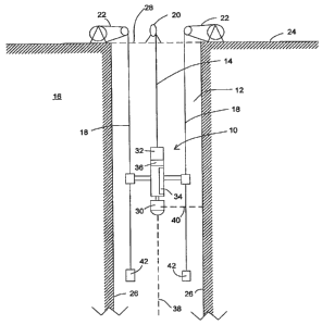
FIG. 1 is a longitudinal cross-sectional view of a borehole with an embodiment
of a
caliper in accordance with the present invention in the borehole.
Detailed Disclosure of the Invention
.
Embodiments of the present invention relate to a caliper and method for
mapping the
dimensions and topography of a formation such as the sidewall of a borehole.
Examples of
formations in which embodiments of the invention can be used include, but are
not limited to,
an oil, gas, pile borehole or barrette that has been drilled or excavated into
the earth. Such
dimensional and topographic information can allow more accurate interpretation
of test
devices positioned in the pile created within the borehole and can allow an
accurate
determination of the volume of concrete needed to fill the pile. Such
information can also
allow more accurate projections of the interaction of the side of the pile
with the side of the
borehole.
Figure 1 shows one embodiment of caliper 10 suspended in borehole 12 by cable
14.
Borehole 12 penetrates earth formation 16. One or more guide cables 18 can
also be
suspended down into borehole 12. In one embodiment, two guide cables 18 are
parallel to

CA 02632687 2008-06-06
WO 2007/075756
PCT/US2006/048549
3
each other and are weighted 42 to fall plumb into borehole 12. In one
embodiment, one or
more cables 14, 18 include a conductor for transmitting commands and/or power
to caliper 10
and for receiving data back from caliper 10. Caliper 10 can be raised and
lowered on cable
14 by draw works 20, moving slidably along guide cables 18. Guide cables 18
are raised and
lowered independently of cable 14, by draw works 22. In one embodiment, all
guide cables
18 are coordinated by being raised and lowered by a single draw work assembly
22. Draw
works 20, 22 can be of any type known in the art, including pulley systems.
Draw works 20,
22 are typically installed at ground level 24. In an embodiment, draw works 20
and 22 are
connected to a common frame structure. In further embodiments, draw works 20
and 22 can
be such that the raising and lowering of a plurality of cables 18 is in
unison.
In one embodiment, guide cables 18 are suspended independently of cable 14,
which
carries caliper 10. This arrangement allows for greater positional control of
guide cables 18.
Positional control of guide cables 18 is desirable for preventing contact
between caliper 10
and interior wall 26 of borehole 12 as caliper 10 descends and ascends, guided
by guide
cables 18. Positioning guide cables 18 in borehole 12 and then lowering
caliper 10 as caliper
10 is guided by guide cable 18 can allow a more accurate determination of the
position of
caliper 10. In an alternative embodiment, cable 14 can be removed and caliper
10 can
incorporate means for moving caliper 10 to propel itself up and down by
gripping on cables
18. Means for propelling up and down a cable are known in the.art and can be
incorporated
in caliper 10 for this purpose. In additional embodiments, caliper 10 can be
fixably attached
to one or more cables 18 and the caliper 10 lowered by lowering cable 18 to
which the caliper
is fixably attached and/or enabling caliper 10 to travel with respect to one
or more cable 18 to
which the caliper 10 is not fixably attached. In another embodiment, caliper
10 can
incorporate a gyroscopic stabilizer and an. internal compass to allow the
.caliper 10 to be
raised and lowered without the use of guide cables 18.
Caliper 10 is insertable into opening 28 of borehole 12 and can include sonar
head 30
for transmitting acoustical energy toward interior wall 26 of borehole 12.
When the acoustic
energy reaches interior wall 26 the acoustic waves are reflected by interior
wall 26 back to
sonar head 30. Sonar head 30 detects the acoustic waves and measures the
elapsed time
between transmission of the acoustical energy and detection of the acoustic
waves. From
elapsed time measurements, the distance from the sonar head to the interior
wall and back in
a certain direction can be determined, allowing determination of the location
of interior wall

CA 02632687 2008-06-06
WO 2007/075756
PCT/US2006/048549
4
26 relative to sonar head 30. Additional embodiments can incorporate a light
source, such as
a laser source. This laser source can be used instead of the sonar head 30 or
in conjunction
with sonar head 30. The laser source can transmit a light beam toward interior
wall 26 that
can be reflected by interior wall 26 and detected by caliper 10. Again, by
measuring the
elapsed time between transmission and detection of the light, the distance
from the laser
source to the interior wall 26 in a certain direction can be determined,
allowing determination
of the location of the interior wall 26.
In one embodiment, caliper 10 includes a motor (not shown). In one embodiment,

caliper 10 includes gears and shafts for enabling the motor to rotate sonar
head 30. In various
embodiments, caliper 10 can include one or more of the following; gyroscope
stabilizer 32,
internal inclinometer 34, internal compass 36, and pressure measuring device.
A pressure
' measuring device can measure the pressure of the caliper's environment in
the fluid in the
formation, where the pressure is a function of the depth and density of the
fluid and can, for
example, be used to provide the density of the fluid when the depth is known.
In one
embodiment, as caliper 10 is raised or lowered in borehole 12, current is
supplied to the
motor via cable 14 which connects caliper 10 to a generator (not shown) on
ground level 24.
. Other electrical signals can travel down cable 14 and/or cable 18. In one
embodiment, sonar
head 30 is rotated by the motor as caliper 10 advances along borehole axis 38.
Acoustic
pulses emitted from sonar head 30 along borehole radius 40 can scan borehole
wall surfaces
26 with such pulses emitted either as the caliper 10 with sonar head 30 is
continuously raised
or lowered, or at multiple fixed depths of the borehole that the sonar head 30
is sequentially
raised or lowered to. By rotating sonar head 30 as the caliper 10 is raising
or lowering, a
spiral or helical pattern of measurements can be accomplished, while allowing
continuous
movement of the caliper 10 and the sonar head.
The speed of the caliper 10 raising or lowering can be varied with time when,
for
example, it is desired to have more or fewer measurements of a certain portion
of the
borehole. Likewise, the rotation speed of the caliper head 10 can vary with
time if, for
example, it is desired to have more or fewer measurements of a certain portion
of the
borehole. A portion of the energy from each acoustic pulse, or laser pulse, is
reflected by
wall surface 26 of borehole 12 along radius 40. back toward sonar head 30,
which detects the
reflected energy. The reflections contain information relating to the
topographic features and
contours of walls 26 of borehole 12. The number of measurements per unit area
of bore hole

CA 02632687 2008-06-06
WO 2007/075756
PCT/US2006/048549
=
, wall 26 can be controlled by controlling the speed of raising and/or
lowering sonar head 30
.. and/or controlling the rotation speed of sonar head 30. In an embodiment,
sonar head 30
rotates one full rotation between advancement intervals of caliper 10 along
borehole axis 38.
3 In this ease, information is gathered in planar fields at discrete
locations along axis 38.
5 = In one embodiment, electronic modules (not shown) on ground level 24
transmit
operating commands down borehole 12 and in return, receives data back that may
be
recorded on a storage medium of any desired type for concurrent or later
manual or
44
f automated processing. Data processor means, such as a suitable computer,
may be provided
1
for performing data analysis in the field in real time. In addition or in the
alternative, the
101 recorded data may be sent to a processing center for post processing of
the data.
Because borehole 12 may contain a fluid that changes in density with changes
in
depth or other position, caliper 10 can be calibrated to take these changes
into effect. In one
embodiment, because the distance between sonar head 30 and each guide cable 18
is known
and constant during a particular operation, a pulse can be directed at a guide
cable 18 and the
15: time lapse between transmission and detection measured. Changes in return
speed at
different positions along axis 38 can be used to calibrate caliper 10 to take
fluid properties
into account to improve the accuracy of the measurement of the distance from
the sonar head
30 to the walls 26. In an embodiment, a pulse can be reflected from cable 18
for each
rotation of the sonar head 30 to provide calibration of the speed of sound
and/or light in the
201 surrounding material for that depth. In another embodiment, a sonar
pulse and a laser pulse
- can be reflected from a known location on or near the walls 26 and the
difference in the speed
= of sound and the speed of light in the surrounding material can be used
to calibrate the
measurement results for the surrounding material.
= In one embodiment, multiple excitation frequencies are available from
which the
25i operator can choose, depending on factors such as the type and
properties of fluid in borehole
12. The choice of excitation frequency is a compromise between the need for
signal
penetration through the borehole fluid using a longer-wavelength, lower
frequency pulse,
more acoustic energy (the borehole fluid can have undesirably attenuating
effects at higher
- pulse frequencies) and the need for spatial resolution that is achievable
using shorter
36õ wavelengths albeit at the expense of higher signal transmission losses.
Embodiments can
utilize multiple frequencies during the same measurement. A specific
embodiment of the
invention pertains to measuring the physical characteristics of a.borehole
having a diameter

CA 02632687 2013-10-10
6
between 1.5 feet and 20 feet, and in another embodiment between 3 feet and 12
feet. In one
specific embodiment, an excitation frequency in the range 50 kHz-300 kHz is
used; in
another specific embodiment, an excitation frequency in the range 500.k.Hz-800
kHz is used;
and in a further specific embodiment, an excitation frequency in the range 1.0
MHz-1.5 MHz
In one embodiment, an inclinometer 42, can be attached to the end, or other
location,
of cable 18, rather than merely weights. Thus, if guide cables 18 are not able
to hang freely,
inclinometers 42 can provide an output signal indicative of the orientation of
the end of each
. -
guide cable 18 in the borehole 12. This situation may be encountered where
borehole 12 is

Representative Drawing
A single figure which represents the drawing illustrating the invention.
Administrative Status

For a clearer understanding of the status of the application/patent presented on this page, the site Disclaimer , as well as the definitions for Patent , Administrative Status , Maintenance Fee  and Payment History  should be consulted.

Administrative Status

Title Date
Forecasted Issue Date 2014-07-08
(86) PCT Filing Date 2006-12-18
(87) PCT Publication Date 2007-07-05
(85) National Entry 2008-06-06
Examination Requested 2011-07-11
(45) Issued 2014-07-08

Abandonment History

There is no abandonment history.

Maintenance Fee

Last Payment of $473.65 was received on 2023-12-04


 Upcoming maintenance fee amounts

Description Date Amount
Next Payment if standard fee 2024-12-18 $624.00
Next Payment if small entity fee 2024-12-18 $253.00

Note : If the full payment has not been received on or before the date indicated, a further fee may be required which may be one of the following

  • the reinstatement fee;
  • the late payment fee; or
  • additional fee to reverse deemed expiry.

Patent fees are adjusted on the 1st of January every year. The amounts above are the current amounts if received by December 31 of the current year.
Please refer to the CIPO Patent Fees web page to see all current fee amounts.

Payment History

Fee Type Anniversary Year Due Date Amount Paid Paid Date
Application Fee $400.00 2008-06-06
Registration of a document - section 124 $100.00 2008-08-28
Maintenance Fee - Application - New Act 2 2008-12-18 $100.00 2008-11-21
Maintenance Fee - Application - New Act 3 2009-12-18 $100.00 2009-12-15
Maintenance Fee - Application - New Act 4 2010-12-20 $100.00 2010-12-15
Request for Examination $800.00 2011-07-11
Maintenance Fee - Application - New Act 5 2011-12-19 $200.00 2011-12-13
Maintenance Fee - Application - New Act 6 2012-12-18 $200.00 2012-12-13
Maintenance Fee - Application - New Act 7 2013-12-18 $200.00 2013-12-05
Final Fee $300.00 2014-04-23
Maintenance Fee - Patent - New Act 8 2014-12-18 $200.00 2014-12-15
Maintenance Fee - Patent - New Act 9 2015-12-18 $200.00 2015-11-25
Maintenance Fee - Patent - New Act 10 2016-12-19 $250.00 2016-12-07
Maintenance Fee - Patent - New Act 11 2017-12-18 $250.00 2017-12-13
Maintenance Fee - Patent - New Act 12 2018-12-18 $250.00 2018-12-12
Maintenance Fee - Patent - New Act 13 2019-12-18 $250.00 2019-12-09
Maintenance Fee - Patent - New Act 14 2020-12-18 $250.00 2020-12-07
Maintenance Fee - Patent - New Act 15 2021-12-20 $459.00 2021-12-06
Maintenance Fee - Patent - New Act 16 2022-12-19 $458.08 2022-12-02
Maintenance Fee - Patent - New Act 17 2023-12-18 $473.65 2023-12-04
Owners on Record

Note: Records showing the ownership history in alphabetical order.

Current Owners on Record
LOADTEST, INC.
Past Owners on Record
HAYES, JOHN A.
Past Owners that do not appear in the "Owners on Record" listing will appear in other documentation within the application.
Documents

To view selected files, please enter reCAPTCHA code :


To view images, click a link in the Document Description column. To download the documents, select one or more checkboxes in the first column and then click the "Download Selected in PDF format (Zip Archive)" or the "Download Selected as Single PDF" button.

List of published and non-published patent-specific documents on the CPD .

If you have any difficulty accessing content, you can call the Client Service Centre at 1-866-997-1936 or send them an e-mail at CIPO Client Service Centre.


Document
Description 
Date
(yyyy-mm-dd) 
Number of pages   Size of Image (KB) 
Abstract 2008-06-06 2 77
Claims 2008-06-06 7 283
Drawings 2008-06-06 1 23
Description 2008-06-06 6 366
Representative Drawing 2008-09-23 1 11
Cover Page 2008-09-25 2 51
Claims 2013-10-10 7 239
Description 2013-10-10 6 348
Cover Page 2014-06-09 2 51
Prosecution-Amendment 2011-07-11 2 58
PCT 2008-06-06 3 93
Assignment 2008-06-06 3 102
Correspondence 2008-09-22 1 25
Assignment 2008-08-28 4 140
Correspondence 2008-08-28 3 85
Correspondence 2008-11-21 1 15
Prosecution-Amendment 2013-10-10 19 774
Prosecution-Amendment 2013-04-10 3 97
Correspondence 2014-04-23 2 59