Note: Descriptions are shown in the official language in which they were submitted.
CA 02635967 2008-07-02
WO 2007/080080
PCT/EP2007/000093
1
A DEVICE AND METHOD OF MEASURING DEPTH AND AZIMUTH
FIELD OF THE INVENTION
The invention relates to a method of measuring depth and/or azimuth of logging
data
related to a physical property of a geological formation surrounding a
wellbore
measured by at least a sensor array, and a device for measuring depth and
azimuth
according to the same method.
Other aspects of the invention relate to a logging tool and a drilling
assembly.
A particular application of the method and the logging tool according to the
invention
relates to the oilfield services industry.
BACKGROUND OF THE INVENTION
Many techniques are known to measure the depth as well as the azimuth of
downhole assemblies deployed within a wellbore. The downhole assemblies may be
a logging tool (used in wireline application) or a drilling assembly (used in
drilling and
logging while drilling applications) which comprise a plurality of sensors for
measuring properties of the geological formation surrounding the wellbore.
Typically, in wireline application, the logging tool is connected to a surface
equipment
via a logging cable. The depth of the logging tool is determined by means of a
calibrated measure wheel at the surface. The wheel has a known circumference
and
is rotated by the logging cable when the logging tool is run into the
wellbore. The
depth may be corrected by taking into account the stretch of the cable due to
the
weight of the cable in the wellbore, the weight of the logging tool and the
history of
the cable stretch characteristics change with usage.
Typically, in logging while drilling application, the drilling assembly is
connected to a
surface equipment via a drill string. The depth of the drilling assembly is
determined
by measuring the length of pipe that enters the well at surface. The depth may
be
corrected for the effects of drill string tension or compression.
During the deployment and operation of the logging tool and drilling assembly,
these
downhole assemblies may move erratically within the well bore (e.g. bouncing
effects, sticking and releasing effects, friction, compression or tension of
the pipe or
cable). Thus, it is often difficult to estimate at a particular instant the
precise depth of
the downhole assembly. In addition, in logging while drilling application, an
additional
error is introduced by the lack of synchronization between the uphole and
downhole
clocks. As a consequence, log produced by the sensors of the downhole assembly
CONFIRMATION COPY
CA 02635967 2014-01-02
2
will be incorrect as a result of the errors made when correlating measurements
performed by the sensors of the downhole assembly with depth measurements made
at the surface. Further, the aforementioned estimated depths will be
insufficiently
precise for high resolution measurements such as images.
SUMMARY OF THE INVENTION
In some cases, it is desirable to propose a depth and/or azimuth measuring
device
and method that overcomes at least one of the drawbacks of the prior art.
According to an aspect, an embodiment of the invention relates to a method of
operating a sensor array for measuring depth and/or azimuth of logging data
related to
a physical property of a geological formation surrounding a wellbore measured
by at
least a sensor array, the method comprising the steps of:
- acquiring and storing a first logging data frame corresponding to a first
position of the
sensor array, and acquiring and storing a second logging data frame
corresponding to
a second position of the sensor array, the first and second position are such
that the
second logging data frame overlaps at least partially the first logging data
frame,
- comparing the first and second logging data frame, and
- calculating a relative change in the depth and/or azimuth of logging data
measured
by the sensor array between the first and second logging data frame.
Optionally, the method may further comprise a step of calculating an actual
depth
value and/or an actual azimuth value of logging data based on the relative
change in
the depth and/or azimuth of logging data and a prior estimation of the depth
and/or
azimuth of logging data.
The step of comparing the first and second logging data frame may include
determining an overlapping area between both logging data frames. Hence, the
displacement of one frame relative to the other can be determined.
The step of determining the overlapping area may include either evaluating the
coherence of the logging data frames by applying a correlation method on both
logging
CA 02635967 2014-01-02
3
data frames, or alternatively evaluating the similarity of the logging data
frames by
applying a semblance method on both logging data frames.
Optionally, the method may further comprise the step of correcting the prior
estimation
of the depth and/or the prior estimation of the azimuth of logging data based
on a
measurement made by a surface depth measuring system or a weight on tool
measuring system.
The logging data may be mechanical, electromagnetic, nuclear or acoustic
measurements.
The first and second logging data frames may be 1 D images or 2D images.
According to another aspect, an embodiment of the invention relates to a
computer
program product for a depth and/or azimuth measuring device arranged to be
deployed into a wellbore, the computer program product comprising a computer
readable medium storing thereon a set of instructions that, when loaded into a
program memory of the depth and/or azimuth measuring device, causes the depth
and/or azimuth measuring device to carry out the steps of a method described
herein.
According to a further aspect, an embodiment of the invention relates to a
device for
measuring depth and/or azimuth of logging data, the device being coupled to at
least a
sensor array for measuring logging data related to at least one property of a
zone
surrounding a wellbore, and comprising a memory buffer and at least one a
processing
module, wherein the processing module of the depth and/or azimuth measuring
device
is arranged to:
- acquire and store into the memory buffer a first logging data frame
corresponding to
a first position of the sensor array and a second logging data frame
corresponding to a
second position of the sensor array, the second logging data frame overlapping
at
least partially the first logging data frame,
- compare the first and second logging data frame, and
- calculate a relative change in the depth and/or azimuth of logging data
between the
first and second logging data frame.
CA 02635967 2014-01-02
4
Optionally, the processing module of the depth and/or azimuth measuring device
may
be further arranged to calculate an actual depth value and/or an actual
azimuth value
of logging data taking into account the relative changes in the depth and/or
azimuth of
logging data and any prior estimation of the depth and/or azimuth of logging
data.
The sensor array may be a 1D sensor array or a 2D sensor array.
According to still a further aspect, an embodiment of the invention relates to
a logging
tool arranged to be deployed into a wellbore and comprising at least a sensor
array for
measuring logging data related to at least one property of a zone surrounding
a
wellbore, wherein the logging tool comprises the depth and/or azimuth
measuring
device disclosed herein.
According to still a further aspect, an embodiment of the invention relates to
a drilling
assembly arranged to drill a wellbore and comprising at least a sensor array
for
measuring logging data related to at least one property of a zone surrounding
a
wellbore, wherein the drilling assembly comprises the depth and/or azimuth
measuring
device disclosed herein.
Thus, an embodiment of the invention may enable an accurate estimation of the
relative depth and/or the relative azimuth of a downhole assembly moving in an
open
or cased wellbore at each moment in time.
The measurements used to determine the relative depth and/or azimuth may be
the
primary measurements of a downhole assembly (e.g. the measurements related to
the
imaging of geological formation resistivity) or may be auxiliary measurements
measured by a specific sensor array. In particular, a method disclosed herein
may be
particularly simple to implement when the measurements of a physical property
of the
surrounding zone method are themselves used to determine the relative depth
and/or
the relative azimuth. As a consequence, accurate logs can be produced with a
method
and device disclosed herein.
CA 02635967 2014-01-02
Further, the relative depth and/or azimuth estimated according to an
embodiment
disclosed herein can be used to improve the analysis and interpretation of
data
acquired on the downhole assembly, in particular images and other measurements
that require knowledge of the relative positions of the data acquired.
Finally, an embodiment of the invention may also enable determining the
absolute
depth and/or the absolute azimuth of a downhole assembly.
These and other aspects of the invention will be apparent from and elucidated
with
reference to the embodiments described hereinafter.
BRIEF DESCRIPTION OF THE DRAWINGS
The present invention is illustrated by way, of example and not limited to the
accompanying figures, in which like references indicate similar elements:
Figure 1.A schematically illustrates a typical onshore hydrocarbon well
location and a
logging application of the invention;
Figure 1.6 schematically illustrates a typical onshore hydrocarbon well
location and a
logging while drilling application of the invention;
Figure 2.A is a cross-section into a portion of a cased wellbore schematically
illustrating a first embodiment of a device for measuring depth and/or azimuth
of
logging data according to the invention;
Figure 2.B is a cross-section into a portion of a cased wellbore schematically
illustrating the implementation of the method of measuring depth and/or
azimuth of
logging data with the first embodiment of the invention shown in Figure 2.A;
Figures 3.A, 3.6 and 3.0 schematically illustrate a method of measuring depth
and/or
azimuth of logging data implemented by the first embodiment of the invention
shown in
Figure 2.A;
Figure 4.A is a cross-section into a portion of a cased wellbore schematically
illustrating a second embodiment of a device for measuring depth and/or
azimuth of
logging data according to the invention;
Figure 4.B is a cross-section into a portion of a cased wellbore schematically
illustrating the implementation of the method of measuring depth and/or
azimuth of
CA 02635967 2014-01-02
5a
logging data with the second embodiment of the invention shown in Figure 4.A;
Figures 5.A and 5.B schematically illustrate the method of measuring depth
and/or
azimuth of logging data implemented by the second embodiment of the invention
shown in Figure 4.A;
Figures 6.A and 6.6 schematically illustrate logging data measured with a
logging tool
or a drilling apparatus where depth was measured according to the invention
and
according to the prior art, respectively;
CA 02635967 2008-07-02
WO 2007/080080
PCT/EP2007/000093
6
Figure 7 is a block diagram illustrating the method of measuring depth and/or
azimuth of logging data according to the invention.
DETAILED DESCRIPTION OF THE INVENTION
In the following description the wording "depth", "azimuth", "property of a
zone
surrounding a wellbore" will have the following meaning.
The "depth" describes a measure of displacement of a device along a
trajectory.
The "azimuth" describes the rotation of the device about the axis of the
trajectory,
relative to a reference which may be a projection of the gravity or magnetic
field
vector on a plane perpendicular to said axis.
The "property of a zone surrounding a wellbore" means either:
- in the case of open hole, the physical or geometrical properties of the
geological
formation,
- in the case of cased hole, the physical or geometrical properties of the
pipe, the
casing, the cemented annulus or the geological formation behind the casing,
The physical or geometrical properties may be measured by, for example,
mechanical, electromagnetic, nuclear or acoustic sensors.
Figure 1.A schematically shows a typical onshore hydrocarbon well location and
surface equipments SE above a hydrocarbon geological formation GF after
drilling
operation has been carried out. At this stage, i.e. before a casing string is
run and
before cementing operations are carried out, the wellbore WB is a bore hole
filled
with a fluid (e.g. a drilling fluid or mud).
Well logging operation may be carried out. The well logging operation serves
to
measure various parameters of the hydrocarbon well geological formation (e.g.
resistivity, porosity, etc... at different depths) and in the well-bore (e.g.
temperature,
pressure, fluid type, fluid flowrate, etc.... at different depths). Such
measurements
are performed by a logging tool TL. Generally, a logging tool comprises at
least one
sensor (e.g. resistivity sonde, mechanical sonde, gamma ray neutron sonde,
accelerometer, pressure sensor, temperature sensor, etc....) and measures at
least
one parameter. It may include a plurality of same or different sensors
sensitive to one
or more parameters. The logging tool is moved up and down in the borehole by
means of a cable LN and gathers data about the various parameters.
CA 02635967 2008-07-02
WO 2007/080080
PCT/EP2007/000093
7
The logging tool may be deployed inside the well-bore by an adapted surface
equipment SE that may include a vehicle SU and an adapted deploying system,
e.g.
a drilling rig DR or the like. Data related to the hydrocarbon geological
formation GF
or to the well-bore WB gathered by the logging tool TL may be transmitted in
real-
time to the surface, for example to the vehicle fitted with an appropriate
data
collection and analysis computer and software.
The logging tool TL may comprise a centralizer CT. The centralizer comprises a
plurality of mechanical arm that can be deployed radially for contacting the
well-bore
wall WBW. The mechanical arms insure a correct positioning of the logging tool
along the central axis of the well-bore hole. The logging tool TL comprises
various
sensors and provides various measurement data related to the hydrocarbon
geological formation GF, or to the casing that may be present in the borehole,
or to
the cemented casing. These measurement data are collected by the logging tool
TL
and transmitted to the surface unit SU. The surface unit SU comprises
appropriate
electronic and software arrangements for processing, analyzing and storing the
measurement data provided by the logging tool TL.
The logging tool TL may also comprise a probe PB for measuring a physical
property
(e.g. the density) of the subsurface formation surrounding the wellbore. Once
the
logging tool is positioned at a desired depth, the probe PB can be deployed
from the
logging tool TL against the bore hole wall WBW by an appropriate deploying
arrangement (e.g. an arm).
The device for measuring depth and/or azimuth MD of logging data of the
invention
may be fitted anywhere on the logging tool TL, including the probe PB and the
centralizer CT.
Figure 1.6 schematically shows a typical onshore hydrocarbon well location and
surface equipments SE above a hydrocarbon geological formation GF after a well-
bore WB drilling operation has been carried out, after a casing string CS has
been
partially run and after cementing operations have been partially carried out
for
sealing the annulus CA (i.e. the space between the well-bore WB and the casing
string CS) in order to stabilize the well-bore.
Typically, the surface equipments SE comprise a plurality of mud tanks and mud
pumps, a derrick, a drawworks, a rotary table, a power generation device and
various
auxiliary devices, etc....
CA 02635967 2008-07-02
WO 2007/080080
PCT/EP2007/000093
8
At this stage, various operations may be carried out, either logging or
further drilling
operations that are shown in Figure 1.B.
For example, a logging tool TL may be deployed into a first portion P1 of the
well-
bore which is a cased portion in order to perform logging operation. The
logging tool
TL was described in relation with Figure 1 and will not be further described.
The
device for measuring depth and/or azimuth MD of logging data of the invention
may
be fitted within the logging tool TL.
Further, a drilling assembly DA may be deployed into a second portion P2 and a
third
portion P3 in order to perform further drilling operation. The second portion
P2 of the
well-bore is an open bore hole. The third portion P3 of the well-bore is a
sensibly
horizontal lateral bore hole.
The drilling assembly DA is coupled to the surface equipments with a drill
string DS.
The device for measuring depth and/or azimuth MD of logging data of the
invention
may be fitted anywhere within the drilling assembly DA in order to perform
logging
while drilling.
It is emphasized that the surface equipments SE, the logging tool TL and the
drilling
assembly DA shown in Figures 1.A and 1.B may comprise other components that
are
not shown for clarity reasons.
The measuring device according to a first and second embodiment of the
invention
that will be described in relation with Figure 2.A and 4.A, respectively, may
be fitted
in any type of downhole assembly (logging tool, drilling assembly, or any
other tool
conveyed in any other fashion). The downhole assembly may be rotated clockwise
or
counterclockwise, move up or down into the wellbore resulting in a positive or
negative variation of the depth and/or azimuth of the downhole assembly into
the
wellbore.
Figure 2.A schematically shows a cross-section into a portion of a cased
wellbore
and illustrates the depth and/or azimuth measuring device MD1 according to a
first
embodiment of the invention.
The depth and/or azimuth measuring device MD1 is coupled to a 1D sensor array
SAID. In the example of Figure 2.A, the 1D sensor array comprises 8 sensors
and is
positioned substantially vertically, thus enabling measuring depth.
Alternatively, it will
CA 02635967 2008-07-02
WO 2007/080080
PCT/EP2007/000093
9
be apparent that the 1D sensor array may also be positioned substantially
horizontally (not shown), thus enabling measuring azimuth. The 1D sensor array
may
be a specific sensor which function is only to be used in the determination of
the
depth and/or azimuth. Alternatively, the 1D sensor array may be part of the
logging
tool TL or the drilling assembly DA (see Figures 1.A and 1.6) which function
is to
determine the physical property of the zone surrounding the wellbore, e.g. the
geological formation GF, the casing CS or the cemented casing. In this
example, the
sensor array SAID comprises resistivity sensors and provides imaging of
geological
formation resistivity.
The depth and/or azimuth measuring device MD1 comprises an electronic
arrangement EA comprising a memory buffer MEM coupled to a processing module
PRO. The processing module PRO is coupled to the 1D sensor array (SAID).
The method of measuring depth and/or azimuth of logging data DAM according to
the invention will now be described in relation with Figures 2.6, 3.A, 3.6,
3.0 and 7.
Figure 2.6 schematically shows a cross-section into a portion of a cased
wellbore
and illustrates two consecutive logging data frames measured by the measuring
device MD1 shown in Figure 2.A.
At a first instant t1 a first logging data frame Fl 1 corresponding to a first
position of
the sensor array SA1 D is acquired (step 51 - ACQ Fl) and stored in the memory
MEM.
A movement of the downhole assembly shown by arrows in Figure 2.A may occur
(step S2 - MVT). Such a movement may be a rotation, a displacement or a
combination thereof.
At a second instant t2 a second logging data frame F12 corresponding to a
second
position of the sensor array SAID is acquired (step S3 - ACQ F2) and stored in
the
memory MEM.
When the first Fl 1 and second F12 logging data frames are separated by an
integer
number of full rotation of the measuring device MD1, the first F11 and second
F12
logging data frames overlap at least partially each other, forming an
overlapping area
0A1 (also shown in Figure 3.C).
CA 02635967 2008-07-02
WO 2007/080080
PCT/EP2007/000093
Figure 3.A schematically illustrates a first measurement curve Cti relating to
the first
logging data frame F11, each measurement being performed by each of the 8
sensors of the 1D sensor array SA1 D example of Figure 2.A corresponding to
the
first position SA1D1 at the first instant t1.
5 Figure 3.6 schematically illustrates a second measurement curve Ct2
relating to the
second logging data frame F12, each measurement being performed by each of the
8 sensors of the 1D sensor array SAID example of Figure 2.A corresponding to
the
second position SA1D2 at the second instant t2.
Figure 3.0 schematically illustrates the best overlap between the first Cti
and the
10 second Ct2 measurement curves from which the relative change in the
depth ADP
can be derived (step S5 - CALC ADP/AAZ). The best overlap can be determined by
comparing the first Cti and the second Ct2 measurement curves (step S4 - COMP
F1/F2). This may be done by calculating, for various relative changes in the
depth
ADP, the area between the curves 0Z1, and determining the relative change in
the
depth ADP at which the area between the curves OZ1 is the most favorable.
Advantageously, the best overlap is determined by applying a correlation or
semblance method (e.g. a known auto-correlation, cross-correlation, or
statistical
correlation method, etc...). Optionally, the actual depth value DP can also be
calculated based on the determined relative change in the depth ADP and a
prior
estimation of the depth (step S5 - CALC DP/AZ).
The azimuth may be determined in an analogous way with a substantially
horizontal
sensor array and will not be further described.
As an alternative not represented in the drawings, it may be impossible to
have a
vertical line of sensors. Such a configuration may arise when the sensor size
is
relatively large, or when there are mechanical constraints to the position of
the
sensors within the downhole assembly. In this case, by monitoring the azimuth
(e.g.
with a magnetometer) while the downhole assembly is rotating, it is possible
to
synthesize a vertical line of data using a sensor array having a non-straight
line
configuration. After all the sensors have passed through one single azimuth,
the
measurement of each sensor may approximate the measurement that would have
been taken by a vertical line of sensors. Subsequently, the depth measuring
method
of the invention may be applied in an analogous way as for a substantially
vertical
sensor array.
CA 02635967 2008-07-02
WO 2007/080080
PCT/EP2007/000093
11
Figure 4.A schematically shows a cross-section into a portion of a cased
wellbore
and illustrates the depth and/or azimuth measuring device MD2 according to a
second embodiment of the invention.
The depth and/or azimuth measuring device MD2 is coupled to a 2D sensor array
SA2D. In the example of Figure 4.A, the 2D sensor array comprises a matrix of
sensors enabling measuring depth and/or azimuth. The 2D sensor array may be a
specific sensor which function is only to be used in the determination of the
depth
and/or azimuth. Alternatively, the 2D sensor array may be part of the logging
tool TL
or the drilling assembly DA (see Figures 1.A and 1.6) which function is to
determine
the physical property of the geological formation GF, casing or cementing CS.
In this
example, the sensor array SA2D comprises resistivity sensors and provides
imaging
of geological formation resistivity.
The depth and/or azimuth measuring device MD2 comprises an electronic
arrangement EA comprising a memory buffer MEM coupled to a processing module
PRO. The processing module PRO is coupled to the 2D sensor array SA2D.
The method of measuring depth and/or azimuth of logging data DAM according to
the invention will now be described in relation with Figures 4.6, 5.A, 5.6 and
7.
Figure 4.6 schematically shows a cross-section into a portion of a cased
wellbore
and illustrates two consecutive logging data frames measured by the measuring
device MD2 shown in Figure 4.A.
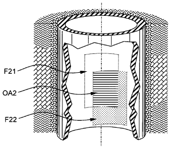
At a first instant t1 a first logging data frame F21 corresponding to a first
position of
the sensor array SA2D is acquired (step 51 - ACQ Fl) and stored in the memory
MEM.
A movement of the downhole assembly shows by arrows in Figure 4.A may occur
(step S2 - MVT). Such a movement may be a rotation, a displacement or a
combination thereof.
At a second instant t2 a second logging data frame F22 corresponding to a
second
position of the sensor array SA2D is acquired (step S3 - ACQ F2) and stored in
the
memory MEM.
The first F21 and second F22 logging data frames overlap at least partially
each
other, forming an overlapping area 0A2. Preferably, between the first t1 and
second
t2 instant, the sensor array SA2D does not move such that the sensor array
falls
CA 02635967 2008-07-02
WO 2007/080080
PCT/EP2007/000093
12
outside the boundaries of the first logging data frame F21 in order to enable
overlapping. However, the second frame can be taken after one, or multiple
rotations,
provided that an overlapping area can be determined.
Figure 5.A schematically illustrates a first logging data frame F21 measured
by the
sensors of the 2D sensor array SA2D corresponding to the first position at the
first
instant ti.
Figure 5.B schematically illustrates a second logging data frame F22 measured
by
the sensors of the 2D sensor array SA2D corresponding to the second position
at the
second instant t2.
The bottom right area of the first logging data frames F21 is similar to the
top left
area of the second logging data frame F22. The overlapping area 0A2 is
delimited by
a broken rectangle in Figures 5.A and 5.B. A correlation or semblance method
is
applied (step S4 - COMP F1/F2) in order to precisely determine the locations
of
identical features in the two successive logging data frames. Then, the
displacements of the features from frame-to-frame can be determined. When the
best overlapping area is determined, the relative change in the depth ADP and
in the
azimuth AAZ can be calculated (step S5 - CALC ADP/AAZ). Then the depth DP and
azimuth AZ may be determined in a similar way as described in relation with
the first
embodiment (step S5 - CALC DP/AZ).
The correlation or semblance method can be applied on the complete logging
data
frames, or alternatively on selected portion logging data frame extracted from
said
complete frames.
Optionally, other measurements may further correct (step S6 - DP=DP0 / AZ=AZ0)
the estimation of the depth and/or the estimation of the azimuth as determined
above.
As an example, with a sensor array of 8 electrodes having a dimension of about
3 inches, the relative position of the electrodes is known with a precision of
0.005 inch. This leads to a small error that keeps adding always in the same
direction. A more important limitation causing the accumulation of errors is
the
resolution of the sensor around +/- 0.2 inch.
The nature of the accumulated error results in a depth accuracy good at a
short-
scale, but deteriorated on a longer scale. In contrast, other measurements are
good
CA 02635967 2008-07-02
WO 2007/080080
PCT/EP2007/000093
13
on long scales but have insufficient resolution on short scales. Therefore,
the
estimation of the absolute depth from the present invention can be improved by
using
an independent depth value DP0 measured for example by a surface depth
measuring system and/or a weight on tool measuring system. The absolute
azimuth
value may be improved by an independent azimuth value AZ0 measured for example
by a magnetometer. Long and short scale estimates can be combined using
optimal
known filtering/statistical methods Thus, the absolute depth and azimuth
measurements can be enhanced on an absolute level.
Other measurements of displacement such as the use of accelerometers with
double
integration methods may also be used to achieve enhancement of the
measurement.
This adjustment can be made in real time if there is a communication between
the
surface equipment and the downhole assembly. This readjustment can also be
made
when the downhole assembly is returned to the surface and when both the
surface
and the downhole logging data are stored in a memory using the same time
reference.
In logging while drilling applications, the standoff i.e. the distance from
the sensor
array to the wellbore wall may vary. This change in the standoff will result
in a
defocusing of the logging data frame that is measured. In such case, the
correlation
or semblance method needs to be able to correlate subsequent logging data
frames
even if the standoff has changed. Another measurement (e.g. an ultrasonic
measurement) may assist to predict the amount of standoff and thereby give a
prediction of amount of change in the logging data frames.
It is to be noted that in both embodiments hereinbefore described, the
location of the
sensor array in the downhole assembly is arbitrary. For example, the sensor
array
may be positioned into the downhole assembly, into a probe pad of a logging
tool, on
a stabilizer of a drilling tool. The position of sensor array mainly depends
on the type
of measurement (electromagnetic, nuclear...), the necessity to perform
measurements close to the geological formation, minimizing the influence of
the
standoff, etc....
Further, in both embodiments, the calculation of the relative depth and/or
azimuth
values may be performed in the downhole assembly itself, e.g. by the
processing
CA 02635967 2008-07-02
WO 2007/080080
PCT/EP2007/000093
14
module PRO, or by the surface equipment SE, e.g. by a computer, the
measurements being stored in a memory of the tool and downloaded when the tool
returns uphole.
Figures 6.A and 6.B show typical logging data image measured with a downhole
assembly.
Figure 6.6 illustrates a logging data image measured with a downhole assembly
where depth was measured according to the prior art. This image shows a range
of
depth between 9732 and 9734 feet where the downhole assembly did not move or
move slower than estimated by the surface measuring device. However, this
situation
was not detected, resulting in a stretched region SR (represented by a broken
line
rectangle).
Figure 6.A illustrates a logging data image measured with a downhole assembly
where depth was measured according to the invention.
The logging data image of Figure 6.A representing the resistivity of the
geological
formation for a depth DP interval and an azimuth AZ interval is obtained after
the
depth over a determined range of time has been calculated according to the
invention, logging data frames and other data have been acquired during this
determined range of time. With the invention, the case of downhole assembly
not
moving or slowly moving can be detected, thus preventing the stretched region
that
can be seen in prior art logging image.
FINAL REMARKS
Though two embodiments with a particular 1D and 2D sensor arrays were
described,
it will be apparent for a person skilled in the art that the invention is also
applicable
with sensor array comprising any number of sensors and that may be positioned
in
any spatial distribution (regular distribution, staggered distribution...).
For example,
the sensor of the array may be distributed according to a spiral like pattern.
The invention was described in relation with resistivity measurements.
Nevertheless,
it will be apparent for a person skilled in the art that the invention is also
applicable to
other kind of measurements from which it is possible to derive overlapping
logging
data frames, e.g. nuclear, ultrasonic or optical measurements, etc...
Further, the invention is not limited to specific correlation or semblance
methods,
since there are many ways of comparing two curves or two images.
CA 02635967 2008-07-02
WO 2007/080080
PCT/EP2007/000093
Though the invention was described in relation with onshore hydrocarbon well
location, it will be apparent for a person skilled in the art that the
invention is also
applicable to offshore hydrocarbon well location. Finally, it will be apparent
for a
person skilled in the art that application of the invention to the oilfield
industry is not
5 limitative as the invention can also be used in others types of surveys.
The drawings and their description hereinbefore illustrate rather than limit
the
invention.
Any reference sign in a claim should not be construed as limiting the claim.
The word
"comprising" does not exclude the presence of other elements than those listed
in a
10 claim. The word "a" or "an" preceding an element does not exclude the
presence of a
plurality of such element.