Note: Descriptions are shown in the official language in which they were submitted.
CA 02637135 2008-07-14
WO 2007/092127 PCT/US2007/000989
APPARENT DIP ANGLE CALCULATION AND IMAGE
COMPRESSION BASED ON REGION OF INTEREST
Inventor: Gamal Hassan; Phil Kurkoski
CROSS REFERENCE TO RELATED APPLICATION
This application is a continuation-in-part of U.S. Patent Application
Serial No. 10/892,011 filed July 15, 2004.
Field of the Invention:
This invention relates generally to borehole logging apparatus for use
during drilling operations and methods for acquiring subsurface measurements
and communicating the data to the surface. More particularly, this invention
relates to subsurface feature identification and efficient transmission of
imaging
data and subsurface structure data in real time in a measurement-while-
drilling
(MWD) tool.
Background of the Art:
Oil well logging has been known for many years and provides an oil
and gas well driller with information about the particular earth formation
being
drilled. In conventional oil well logging, after a well has been drilled, a
probe
known as a sonde is lowered into the borehole and used to determine some
characteristic of the formations which the well has traversed. The probe is
typically a hermetically sealed steel cylinder which hangs at the end of a
long
cable which gives mechanical support to the sonde and provides power to the
instrumentation inside the sonde. The cable also provides communication
channels for sending information up to the surface. It thus becomes possible
to
measure some parameter of the earth's formations as a function of depth, that
is,
while the sonde is being pulled uphole. Such "wireline" measurements are
CA 02637135 2008-07-14
WO 2007/092127 PCT/US2007/000989
normally done in real time (however, these measurements are taken long after
the
actual drilling has taken place).
A wireline sonde usually transmits energy into the formation as well as
a suitable receiver for detecting the same energy returning from the formation
to
provide acquisition of a parameter of interest. As is well known in this art,
these
parameters of interest include electrical resistivity, acoustic energy, or
nuclear
measurements which directly or indirectly give information on subsurface
densities, reflectances, boundaries, fluids and lithologies among many others.
Examples of prior art wireline density devices are disclosed in U. S.
Pat. Nos. 3,202,822, 3,321,625, 3,846,631, 3,858,037, 3,864,569 and 4,
628,202.
Wireline formation evaluation tools (such as gamma ray density tools) have
many
drawbacks and disadvantages including loss of drilling time, the expense and
delay involved in tripping the drillstring so as to enable the wireline to be
lowered
into the borehole and both the build up of a substantial mud cake and invasion
of
the formation by the drilling fluids during the time period between drilling
and
taking measurements. An improvement over these prior art techniques is the art
of
measurement-while-drilling (MWD) in which many of the characteristics of the
formation are determined substantially contemporaneously with the drilling of
the
borehole.
Measurement-while-drilling (MWD) logging either partly or totally
eliminates the necessity of interrupting the drilling operation to remove the
drillstring from the hole in order to make the necessary measurements
obtainable
by wireline techniques. In addition to the ability to log the characteristics
of the
formation through which the drill bit is passing, this information on a real
time
basis provides substantial safety and logistical advantages for the drilling
operation.
2
CA 02637135 2008-07-14
WO 2007/092127 PCT/US2007/000989
One potential problem with MWD logging tools is that the
measurements are typically made while the tool is rotating. Since the
measurements are made shortly after the drillbit has drilled the borehole,
washouts are less of a problem than in wireline logging. Nevertheless, there
can
be some variations in the spacing between the logging tool and the borehole
wall
("standoff') with azimuth. Nuclear measurements are particularly degraded by
large standoffs due to the scattering produced by borehole fluids between the
tool
and the formation.
U.S. Pat. No. 5,397,893 to Minette, the contents of which are fully
incorporated herein by reference, teaches a method for analyzing data from a
MWD formation evaluation logging tool which compensates for rotation of the
logging tool (along with the rest of the drillstring) during measurement
periods.
The density measurement is combined with the measurement from a borehole
caliper, preferably an acoustic caliper. The acoustic caliper continuously
measures
the standoff as the tool is rotating around the borehole. If the caliper is
aligned
with the density source and detectors, this gives a determination of the
standoff in
front of the detectors at any given time. This information is used to separate
the
density data into a number of bins based on the amount of standoff. After a
pre-set
time interval, the density measurement can then be made. The first step in
this
process is for short space (SS) and long space (LS) densities to be calculated
from
the data in each bin. Then, these density measurements are combined in a
manner
that minimizes the total error in the density calculation. This correction is
applied
using the "spine and ribs" algorithm and graphs such as that shown in Figure
1. In
the figure, the abscissa 1 is the difference between the LS and SS densities
while
the ordinate 3 is the correction that is applied to the LS density to give a
corrected
density using the curve 5.
3
CA 02637135 2008-07-14
WO 2007/092127 PCT/US2007/000989
U.S. Pat. No. 5,513,528 to Holenka et al teaches a method and
apparatus for measuring formation characteristics as a function of azimuth
about
the borehole. The measurement apparatus includes a logging while drilling tool
which turns in the borehole while drilling. The down vector of the tool is
derived
first by determining an angle 0 between a vector to the earth's north magnetic
pole, as referenced to the cross sectional plane of a measuring while drilling
(M)VD) tool and a gravity down vector as referenced in the plane. The logging
while drilling (LWD) tool includes magnetometers and accelerometers placed
orthogonally in a cross-sectional plane. Using the magnetometers and/or
accelerometer measurements, the toolface angle can usually be determined. The
angle 0 is transmitted to the LWD tool thereby allowing a continuous
determination of the gravity down position in the LWD tool. Quadrants, that
is,
angular distance segments, are measured from the down vector. Referring to
Figure 2 (which is Holenka et al's FIG. lOS illustrating a LWD tool 100
rotating
in an inclined borehole 12), an assumption is made that the down vector
defines a
situation in which the standoff is at a minimum, allowing for a good spine and
rib
correction. A drawback of the Holenka et al method is that the assumption of
minimum standoff is not necessarily satisfied, so that the down position may
in
fact correspond to a significant standoff; without a standoff correction the
results
may be erroneous.
In a centralized or stabilized tool, the standoff will generally be
uniform with azimuth. Holenka (U.S. Pat. No. 5,513,528) and Edwards (U.S. Pat.
No. 6,307,199) also show how azimuthal measurements of density may be
diagnostic of bed boundaries intersected by an inclined borehole. In the
absence
of standoff corrections, this can only be a qualitative measurement.
U.S. Paterit No. 6,584,837 to Kurkoski, fully incorporated by reference
herein, discloses a LWD density sensor that includes a gamma ray source and at
4
CA 02637135 2008-07-14
WO 2007/092127 PCT/US2007/000989
least tviro Nal detectors spaced apart from the source for determining
measurements indicative of the formation density. A magnetometer on the drill
collar measures the relative azimuth of the Nal detectors. An acoustic caliper
is
used for making standoff measurements of the NaI detectors. Measurements made
by the detectors are partitioned into spatial bins defined by standoff and
azimuth.
Within each azimuthal sector, the density measurements are compensated for
standoff to provide a single density measurement for the sector. The azimuthal
sectors are combined in such a way as to provide a compensated azimuthal
geosteering density. The method of the invention may also be used with neutron
porosity logging devices.
MWD instruments, in some cases, include a provision for sending at
least some of the subsurface images and measurements acquired to recording
equipment at the earth's surface at the time the measurements are made using a
telemetry system (i.e. MWD telemetry). One such telemetry system modulates the
pressure of a drilling fluid pumped through the drilling assembly to drill the
welibore. The fluid pressure modulation. telemetry systems known in the art,
however, are limited to transmitting data at a rate of at most only a few bits
per
second. Because the volume of data measured by the typical image-generating
well logging instrument is relatively large, at present, borehole images are
-generally available only using electrical cable-conveyed instruments, or
after an
MWD instrument is removed from the wellbore and the contents of an internal
storage device, or memory, are retrieved.
Many types of well logging instruments have been adapted to make
measurements which can be converted into a visual representation or "image" of
the wall of a wellbore drilled through earth formations. Typical instruments
for
developing images of parameters of interest measurements include density
measuring devices, electrical resistivity measuring devices and acoustic
reflectance/travel time measuring devices. These instruments measure a
property
CA 02637135 2008-07-14
WO 2007/092127 PCT/US2007/000989
of the earth formations proximate to the wall of the wellbore, or a related
property, with respect to azimuthal direction, about a substantial portion of
the
circumference of the wellbore. The values of the property measured are
correlated
to both their depth position in the weilbore and to their azimuthal position
with
respect to some selected reference, such as geographic north or the
gravitationally
uppermost side of the wellbore. A visual representation is then developed by
presenting the values, with respect to their depths and azimuthal
orientations, for
instance, using a color or gray tone which corresponds to the value of the
measured property.
One method known in the art for transmitting image-generating
measurements in pressure modulation telemetry is described, for example, in
U.S.
Pat. No. 5,519,668 issued to Montaron. This method includes making resistivity
measurements at preselected azimuthal orientations, and transmitting the
acquired
resistivity values to the surface through the pressure modulation telemetry.
The
method described in the Montaron '668 patent requires synchronization of the
resistivity measurements to known rotary orientations of the MWD instrument to
be able to decode the image data at the surface without transmitting the
corresponding rotary orientations at which the measurements were made.
U.S. Patent No. 6,405,136 to Li, et al fully incorporated by reference
herein, discloses a method for compressing a frame of data representing
parameter
values, a time at which each parameter value was recorded, and an orientation
of a
sensor at the time each parameter value was recorded. Generally the method
includes performing a two-dimensional transform on the data in the orientation
domain and in a domain related to the recording time. In one embodiment, the
method includes calculating a logarithm of each parameter value. In one
embodiment, the 2-D transform includes generating a Fourier transform of the
logarithm of the parameter values in the azimuthal domain, generating a
discrete
cosine transform of the transform coefficients in the time domain. This
6
CA 02637135 2008-07-14
WO 2007/092127 PCT/US2007/000989
embodiment includes quantizing the coefficients of the Fourier transform and
the
discrete cosine transform. One embodiment of the method is adapted to transmit
resistivity measurements made by an LWD instrument in pressure modulation
telemetry so that while-drilling images of a wellbore can be generated. The
one
embodiment includes encoding the quantized coefficients, error encoding the
encoded coefficients, and applying the error encoded coefficients to the
pressure
modulation telemetry.
Other data compression techniques, for various applications, are
described in several other U.S. patents, for example, U.S. Pat. No. 5,757,852
to
Jericevic et al; U.S. Pat. No. 5,684,693 to Li; U.S. Pat. No. 5,191,548 to
Balkanski et al; U.S. Pat. No. 5,301,205 to Tsutsui et al; U.S. Pat. No.
5,388,209
to Akagiri; U.S. Pat. No. 5,453,844 to George et al; U.S. Pat. No. 5,610,657
to
Zhang; and U.S. Pat. No. 6,049,632 to Cockshott et al. Many prior art data
compression techniques are not easily or efficiently applicable to the
extremely
low bandwidth and very high noise level of the communication methods of the
typical MWD pressure modulation telemetry system, and, have not been suitable
for image transmission by such telemetry.
U.S. Application 10/167,332 (Publication 20020195276 Al) to
Dubinsky et al, entitled "Use of Axial Accelerometer for Estimation of
Instantaneous ROP Downhole for Lwd and Wireline Applications" the contents of
which are incorporated herein by reference, disclose that determination of the
rate
of penetration (ROP) of drilling has usually been based upon surface
measurements and may not be an accurate representation of the actual ROP. This
can cause problems in Logging While Drilling (LWD). . Because of the lack of a
high-speed surface-to-downhole communication while drilling, a conventional
method of measuring ROP at the surface does not provide a solution to this
problem. However, the instantaneous ROP can be derived downhole with a
certain degree of accuracy by utilizing an accelerometer placed in (or near)
the
7
CA 02637135 2008-07-14
WO 2007/092127 PCT/US2007/000989
tool to measure acceleration in the axial direction. When three-component
accelerometers are used, the method may be used to determine the true vertical
depth of the borehole.
There is a need for a method of determining subsurface features in
downhole logging data, for example with azimuthal density variations from
measurements made by a MWD logging tool. Such a method preferably provides
for real-time determination of down hole parameter for communication to the
surface, or provides for real time imaging of the subsurface environment
during
drilling operations. The present invention satisfies this need. It is
desirable to have
a system which enables transmission of data for imaging a wellbore through
pressure modulation or other telemetry so that images of a wellbore can be
developed during the drilling of a wellbore, wherein the rotary orientation of
each
image-developing measurement is included in the transmitted data. It is also
desirable to efficiently and timely determine estimates of positions and
orientations of boundaries between layers of earth formations.
8
CA 02637135 2008-07-14
WO 2007/092127 PCT/US2007/000989
SUMMARY OF THE INVENTION
The present invention provides a method and apparatus for logging an
earth formation and acquiring subsurface information wherein a logging tool is
conveyed in a borehole to obtain parameters of interest. The parameters of
interest obtained may be density, acoustic, magnetic or electrical values as
known
in the art. As necessary, an azimuth associated with the parameters of
interest
measurements are obtained and corrections applied. The corrected data may be
filtered and/or smoothed. The parameters of interest associated with azimuthal
sectors are formed into a plurality of Cost Functions from which Regions of
Interest are determined to resolve characteristics of the Features of interest
within
the Regions of Interest. Also, for initial delineation of Regions of Interest
and
associated Features, Cost Functions from a plurality of sectors may be
combined
to efficiently obtain prospective areas of the Cost Functions. Characteristics
of
these Features may be determined to obtain time or depth positions of bed
boundaries and the Dip Angle of the borehole relative to subsurface
structures, as
well as the orientation of the logging equipment (borehole) and subsurface
structure. Characteristics of the Features include time, depth, lithologies,
structural depths, dip and thicknesses. The Regions of Interest may be
generally
characterized according to the behavior of the Regions in the neighborhood of
various subsurface features. For example, a thin-bed type response may be
characterized where the Region of Interest spans two local maxima with a local
minimum between the maxima. There are at least four types of features (i.e.
features of interest) that may be identified and/or extracted from Regions of
Interest.
9
CA 02637135 2008-07-14
WO 2007/092127 PCT/US2007/000989
BRIEF DESCRIPTION OF THE FIGURES
The present invention and its advantages will be better understood by
referring to the following detailed description and the attached drawings in
which:
Figure 1(PRIOR ART) shows an example of how density measurements made
from a long spaced and a short spaced tool are combined to give a corrected
density;
Figure 2 (PRIOR ART) shows an idealized situation in which a rotating tool in
a
wellbore has a minimum standoff when the tool is at the bottom of the
wellbore;
Figure 3 shows a schematic diagram of a drilling system having a drill string
that
includes an apparatus according to the present invention;
Figure 4 illustrates a flow chart of the present invention;
Figure 5A illustrates raw density data with a Region of Interest;
Figure 5B illustrates a cost function display of obtained data with a Region
of
Interest and a Feature in the Region of Interest;
Figure 5C illustrates types of Features that may be associated with a Region
of
Interest;
Figure 6A illustrates a function that represents the Dip Angle relative to the
well
bore;
Figure 6B illustrates the relationship of Regions of Interest with Features
and Dip
Angle among the several azimuthal sectors, and shows both raw and smoothed
(filtered) data;
Figure 7 illustrates an estimate of data size sample versus DC value for the
Discrete Cosine Transform;
Figure 8 illustrates a data scanning method according to the Embedded Zerotree
Wavelet Encoder;
Figure 9 illustrates raw density data across 8 sectors;
Figure 10 illustrates an uncompressed image reconstructed using the present
invention with a compression of 300:1;
CA 02637135 2008-07-14
WO 2007/092127 PCT/US2007/000989
Figure 11 illustrates an uncompressed image reconstructed using the present
invention with a compression of 150:1;
Figure 12 illustrates an uncompressed image reconstructed using the present
invention with a compression of 100:1;
Figure 13 illustrates the acc error versus the compression ratio;
Figure 14 illustrates the Root-mean-square (RMS) error versus the compression
ratio;
Figure 15 is a flow chart of an embodiment of the present invention;
Figure 16 is a flow chart of an embodiment of the present invention; and
Figure 17 is a flow chart of an embodiment of the present invention.
While the invention will be described in connection with its preferred
embodiments, it will be understood that the invention is not limited thereto.
It is
intended to cover all alternatives, modifications, and equivalents which may
be
included within the spirit and scope of the invention, as defined by the
appended
claims.
DETAILED DESCRIPTION OF THE INVENTION
Figure 3 shows a schematic diagram of a drilling system 110 having a
downhole assembly containing an acoustic sensor system and the surface devices
according to one embodiment of present invention. As shown, the system 110
includes a conventional derrick 111 erected on a derrick floor 112 which
supports
a rotary table 114 that is rotated by a prime mover (not shown) at a desired
rotational speed. A drill string 120 that includes a drill pipe section 122
extends
downward from the rotary table 114 into a borehole 126. A drill bit 150
attached
to the drill string downhole end disintegrates the geological formations when
it is
rotated. The drill string 120 is coupled to a drawworks 130 via a kelly joint
121,
swivel 118 and line 129 through a system of pulleys 127. During the drilling
operations, the drawworks 130 is operated to control the weight on bit and the
rate
11
CA 02637135 2008-07-14
WO 2007/092127 PCT/US2007/000989
of penetration of the drill string 120 into the borehole 126. The operation of
the
drawworks is well known in the art and is thus not described in detail herein.
During drilling operations a suitable drilling fluid (commonly referred
to in the art as "mud") 131 from a mud pit 132 is circulated under pressure
through the drill string 120 by a mud pump 134. The drilling fluid 131 passes
from the mud pump 134 into the drill string 120 via a desurger 136, fluid line
138
and the kelly joint 121. The drilling fluid is discharged at the borehole
bottom
151 through an opening in the drill bit 150. The drilling fluid circulates
uphole
through the annular space 127 between the drill string 120 and the borehole
126
and is discharged into the mud pit 132 via a return line 135. Preferably, a
variety
of sensors (not shown) are appropriately deployed on the surface according to
known methods in the art to provide information about various drilling-related
parameters, such as fluid flow rate, weight on bit, hook load, etc.
A surface control unit 140 receives signals from the downhole sensors
and devices via a sensor 143 placed in the fluid line 138 and processes such
signals according to programmed instructions provided to the surface control
unit.
The surface control unit displays desired drilling parameters and other
information on a display/monitor 142 which information is utilized by an
operator
to control the drilling operations. The surface control unit 140 contains a
computer, memory for storing data, data recorder and other peripherals. The
surface control unit 140 also includes models and processes data according to
programmed instructions and responds to user commands entered through a
suitable means, such as a keyboard. The control unit 140 is preferably adapted
to
activate alarms 144 when certain unsafe or undesirable operating conditions
occur.
A drill motor or mud motor 155 coupled to the drill bit 150 via a drive
shaft (not shown) disposed in a bearing assembly 157 rotates the drill bit 150
when the drilling fluid 131 is passed through the mud motor 155 under
pressure.
12
CA 02637135 2008-07-14
WO 2007/092127 PCT/US2007/000989
The bearing assembly 157 supports the radial and axial forces of the drill
bit, the
downthrust of the drill motor and the reactive upward loading from the applied
weight on bit. A stabilizer 158 coupled to the bearing assembly 157 acts as a
centralizer for the lowermost portion of the mud motor assembly.
In the preferred embodiment of the system of present invention, the
downhole subassembly 159 (also referred to as the bottomhole assembly or
"BHA") which contains the various sensors and MWD devices to provide
information about the formation and downhole drilling parameters and the mud
motor, is coupled between the drill bit 150 and the drill pipe 122. The
downhole
assembly 159 preferably is modular in construction, in that the various
devices are
interconnected sections so that the individual sections may be replaced when
desired.
Still referring back to Figure 3, the BHA also preferably contains
sensors and devices in addition to the above-described sensors. Such devices
include a device for measuring the formation resistivity near and/or in front
of the
drill bit, a gamma ray device for measuring the formation gamma ray intensity
and devices for determining the inclination and azimuth of the drill string.
The
formation resistivity measuring device 164 is preferably coupled above the
lower
kick-off subassembly 162 that provides signals, from which resistivity of the
formation near or in front of the drill bit 150 is determined. A dual
propagation
resistivity device ("DPR") having one or more pairs of transmitting antennae
166a
and 166b spaced from one or more pairs of receiving antennae 168a and 168b is
used. Magnetic dipoles are employed which operate in the medium frequency and
lower high frequency spectrum. In operation, the transmitted electromagnetic
waves are perturbed as they propagate through the formation surrounding the
resistivity device 164. The receiving antennae 168a and 168b detect the
perturbed
waves. Formation resistivity is derived from the phase and amplitude of the
detected signals. The detected signals are processed by a downhole circuit
that is
13
CA 02637135 2008-07-14
WO 2007/092127 PCT/US2007/000989
preferably placed in a housing 170 above the mud motor 155 and transmitted to
the surface control unit 140 using a suitable telemetry system 172. In
addition to
or instead of the propagation resistivity device, a suitable induction logging
device may be used to measure formation resistivity.
The inclinometer 174 and gamma ray device 176 are suitably placed
along the resistivity measuring device 164 for respectively determining the
inclination of the portion of the drill string near the drill bit 150 and the
formation
gamma ray intensity. Any suitable inclinometer and gamma ray device, however,
may be utilized for the purposes of this invention. In addition, an azimuth
device
(not shown), such as a magnetometer or a gyroscopic device, may be utilized to
determine the drill string azimuth. Such devices are known in the art and are,
thus, not described in detail herein.. In the above-described configuration,
the
mud motor 155 transfers power to the drill bit 150 via one or more hollow
shafts
that run through the resistivity measuring device 164. The hollow shaft
enables
the drilling fluid to pass from the mud motor 155 to the drill bit 150. In an
alternate embodiment of the drill string 120, the mud motor 155 may be coupled
below resistivity measuring device 164 or at any other suitable place.
The drill string contains a modular sensor assembly, a motor assembly
and kick-off subs. In a preferred embodiment, the sensor assembly includes a
resistivity device, gamma ray device and inclinometer, all of which are in a
common housing between the drill bit and the mud motor. The downhole
assembly of the present invention preferably includes a MWD section 168 which
contains a nuclear formation porosity measuring device, a nuclear density
device,
an acoustic sensor system placed, and a formation testing system above the mud
motor 164 in the housing 178 for providing information useful for evaluating
and
testing subsurface formations along borehole 126. A downhole processor may be
used for processing the data.
14
CA 02637135 2008-07-14
WO 2007/092127 PCT/US2007/000989
Wireline logging tools have been used successfully to produce
subsurface images. For MWD applications, density tool measurements and other
measurements have been stored in the MWD tool's memory. Therefore
subsurface images and parameter determinations haven't been generally
available
for real time applications such as geosteering.
The present invention which provides for acquiring parameters of
interest is discussed with reference to a density measurement tool that emits
nuclear energy, and more particularly gamma rays, but the method of the
present
invention is applicable to other types of logging instruments as well (e.g.,
acoustic
methods, magnetic resonance and electrical methods). Wireline gamma ray
density probes are well known and comprise devices incorporating a gamma ray
source and a gamma ray detector, shielded from each other to prevent counting
of
radiation emitted directly from the source. During operation of the probe,
gamma
rays (or photons) emitted from the source enter the formation to be studied,
and
interact with the atomic electrons of the material of the formation by
photoelectric
absorption, by Compton scattering, or by pair production. In photoelectric
absorption and pair production phenomena, the particular photons involved in
the
interacting are removed from the gamma ray beam. Instruments for making
measurements of acoustic properties and gamma-gamma density have several
advantages known in the art, and it should be understood that the instruments
disclosed are not the only instruments that can be used to make such
measurements. Accordingly, the invention is not to be limited to measurements
of
parameters of interest made by the particular instruments described herein.
The present invention provides for subsurface feature extraction, data
compression, dip 'angle calculation, and semi-real-time data transmission to
the
surface. Transmission of raw or reduced subsurface data in near real-time to
the
surface provides for calculation of subsurface structure dip angles in semi or
near
real time for geosteering. The invention may be implemented in firmware and/or
CA 02637135 2008-07-14
WO 2007/092127 PCT/US2007/000989
software downhole. For example, the invention provides for receiving the
acquired subsurface data divided into sectors (eight, for example), the data
are
compressed, the apparent dip may be calculated, the data and/or the
calculations
may be transmitted to the surface and uncompressed for display. For example a
formation bed boundary may display as a sine wave. An example product is a
downhole apparatus with a processor with software that receives density data
which may be divided into sectors (for example in eight sectors), compresses
the
data, calculates the apparent dip angle, formats the data for transmission,
uncompresses the data at the surface and formats the data for further uses.
The compression algorithm and apparent dip angle calculation are based
on feature extraction concepts. The present invention provides an
implementation
in three modules: i) compression, ii) reconstruction and iii) display.
The compression module receives data (which may be formatted in
blocks) of the density for the standoff sectors, for example eight sectors,
along
with an optional set of parameters which may be selected from predefined
parameters to customize the compression according to user need and a priori
knowledge of the downhole enviroment. This module runs downhole to compress
the image, code the image, calculate the parameters of the dip angle, code the
parameters of the dip angle, format the data and transmit the data to the
telemetry.
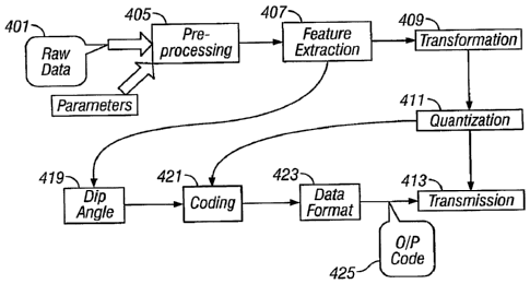
Figure 4 illustrates a block diagram. Raw data 401 along with selected
parameters 403 goes into the Preprocessing Module 405. The Preprocessing
Module 405 ensures that data values are in expected ranges, for example
density
is in the range from 1.5 gm/cc to 3gm/cc. In the case where the density data
has a
value outside this range, the preprocessing module either interpolates the
data or
generates a segmentation based on the number of invalid or null data points.
The
preprocessing module receives both the data and the compression parameters
from the memory module, which may be flash memory. The parameters may be
preset or supplied by downlink.
16
CA 02637135 2008-07-14
WO 2007/092127 PCT/US2007/000989
The preprocessing module 405 performs three separate tasks. The first
task is to get the parameters of the algorithm. Based on the downlink or
preset
parameters, the parameters are set in memory. The algorithm then passes the
parameters to the data collection procedure. A flash memory module is one way
that parameters and instructions may be stored and provided for the present
invention.
The second task is data collection. Based on the parameters for the
compression, pointers are going to be generated to point to the start*of each
data
block that needs to be processed and the block lengths.
Third task is to check the density data values. In some cases density
data values appear in the memory as a null value for many reasons. The
preprocessing module 405 applies the following strategy on the null value: If
the
number of reading that contains a null value is less than or equal to a
selected
value, an interpolation is made. If the number of the null data that contains
a null
'value is more than the selected value, the image is divided into two parts,
which is
called segmentation.
The Feature Extraction Module 407 runs if it has been chosen or
enabled (for example in the flash memory parameters). The feature extraction
module generates a cost function based on both the direction of the change and
the change in the value of the parameter of interest (e.g., density data). Any
maximum or minimum of that cost function, or variations of maxima and minima,
indicates the possible locations of bed boundaries, i.e. the possibility of a
feature.
The region between the location of the two zeros around the maximum or the
minimum that results from the first derivative of that cost function
represents a
region of interest i.e. the region that likely contains one or more features
of
interest. The block of data or number of samples within a cost function may be
set arbitrarily. If the absolute value of the last value of the cost function
is close
to zero, it means that there are no features that share the current block of
data and
17
CA 02637135 2008-07-14
WO 2007/092127 PCT/US2007/000989
the next block of data. If the absolute value of the cost function value is
close to
or greater than one, it means that there are feature/features shared
between/among
the current block of data and the next block of data. The distance between the
location of the last zero of the first derivative of the cost function and the
end of
the current data block determine an overlap region. The overlap region will be
added to the next adjacent block of data. This guarantees that the next block
of
data will contain a complete feature.
Figure 5A illustrates raw data containing features of interest. Figure
5B illustrates the Cost Function, including the Feature location and a Region
of
Interest. This feature could be a "thin bed" or other subsurface structure or
bedding boundary.
Extracting the Feature characteristics from within the Cost Function
is accomplished by examination and comparison of the behavior of the
excursions
of the waveform (or data trace) in relation to a chosen reference or in
relation to
localized changes in the Cost Function. As illustrated in Figure 5B, the Cost
Function is analyzed to discover parameters that satisfy all chosen
constraints,
and produce an optimum value for determining features of interest in the Cost
Function. The Cost Function examination optimally works out how to adjust
the design variables for subsequent runs. This produces an optimized design
for
efficient Feature identification and extraction. In the example. shown here,
the
Region of Interest spans a waveform section of parameter values that is the
area
between and including two local maxima. These local maxima bracket a local
minimum, which minimum coincides with the position of a Feature. Suitable
wavelet functions may be chosen to deconvolve the Feature efficiently to
delineate these maxima and minima in order obtain feature positions in terms
of
time, depth, dip angle or other characterisitics.
While Figure 5B illustrates a Region of Interest spanning local
minima, there are three other features of interest that may be found in and
around
18
CA 02637135 2008-07-14
WO 2007/092127 PCT/US2007/000989
a Region of Interest, which Features are illustrated in Figure 5C relative to
an
arbitrary reference 509 demarking relative positive from relative negative
values
for purposes of illustration. Parameters of interest such as density may all
be
obtained as positive values, so it is the local variations that vary around an
arbitrary reference. In addition to the local minima 501, other Feature types
include local maxima 503, a transition from a local maximum to a local minimum
505, and a transition from a local minimum to a local maximum 507. A local
maxima feature 503 could represent a low density thin bed; a local minimum 501
can represent a high density thin bed. Whether a bed is termed `thin' or not,
of
course, is relative to both bed size and/or sample interval. An example of
transition from local maximum to local minimum 505 is a step decrease in a
density reading. An example of transition from local minimum to local maximum
507 is a step increase in a density reading. There are many choices for
wavelets
that may be used to efficiently identify Features within Regions of Interest.
Calculation of the Apparent Dip Angle: Dip Angle calculation is
illustrated at 419 in Figure 4. Because a plane intersects a well bore as a
periodic
function, fitting a suitable mathematical function, for example a
transcendental or
a wavelet function, to the Feature position data as illustrated in Figure 6A
is
straightforward (e.g., a Discrete Cosine Transfonn). Figure 6A illustrates a
function that represents the Dip Angle 601 relative to the well bore across
several
sectors. The dip angle function 601 along the sections of the well bore
conforms
to the Feature positions that have been determined from the analysis of the
Cost
Function. The Cost Function as illustrated in Figure 6B across multiple
azimuthal sectors indicates the location of the Region of Interest where a
Feature exists along the Dip Angle 601. If the cost function has a minimum
value it means that the density data has been decreasing and we will look for
a
local minimum value in the Region of Interest. If the cost function has a
maximum value it means that the density data has been increased and we will
19
CA 02637135 2008-07-14
WO 2007/092127 PCT/US2007/000989
look for a maximum within the Region of Interest (for example a Feature such
as 501 in Figure 5B and 5C).
Figure 6B illustrates a smoothed version of the data with the region of
interest generated for each sector. The direction of change of the total
density data
may be examined in the eight sectors in both the Raw Data and the same eight
sectors of the Smooth Data smoothed version for the raw data with the region
of
interest. For a decision to be made in preprocessing (e.g. Figure 4
preprocessing
405) that there is a feature of interest in a specific location, the following
parameters are a non-exclusive group that may be used: 1) The time location
where the minimum or maximum value of the feature is located, 2) The peak to
peak amplitude of the feature (and how many samples), 3) the direction of the
apparent dip angle with respect to the tool (or borehole).
Figure 6B shows the calculation of the apparent dip angle. The dip may
be determined by fitting a function, for example the function represented by
the
line 601, superimposed on the Features of the data with adjacent sectors
Region
of Interest. The image trace of desired imaging features of interest such as
bedding boundaries or other subsurface structure boundaries will most often
cross
boreholes with a sinusoidal behavior. Bedding boundaries will display as a
sinusoid. This sinusoidal behavior of the Features (i.e., 601) allows a data
compression related algorithm such as the 2-D Discrete Cosine Transform (DCT)
to operate with good results, and for the apparent dip angle to fall out of
the
compression process when energy of the transform terms is minimized.
I'ransformation is illustrated at 409 in Figure 4. The 2-D Discrete Cosine
Transform (DCT) has been used as a method of energy localization. The 1-D
DCT for a vector of length N is given by equation (1), for the range m to N-1.
The DCT will be calculated in the sector direction then in the time or depth
dimension.
CA 02637135 2008-07-14
WO 2007/092127 PCT/US2007/000989
N-1
y(m) _F-72~, I x(k) cos (2k + 1)m ~ m= 0
k=o 2N (1)
1
)m2r rn.0
y(m) = jl-x(k)cos(2k+l
,~_0 2N
e density data range from 1.5 g/cc to 3.00 g/cc (within a fairly
Since th
narrow range), the Discrete Cosine (DC) value may be replaced by the
difference
between the DC value and its estimate. The estimate value of the DC is based
on
the size of the. data. Figure 7 illustrates the estimate DC value of the 2-D
DCT.
The x-axis shows the size of the data. The y-axis shows the estimate DC value
of
the 2-D DCT.
The output matrix of DCT coefficients contains integers. The signal
energy lies at relatively low frequencies; these appear in the upper left
corner of
the DCT (Table 1). The lower right values represent higher frequencies, and
are
often small enough to be neglected with little visible distortion. Table 1
shows
how the DCT operates on the 8 by 8 matrix.
21
CA 02637135 2008-07-14
WO 2007/092127 PCT/US2007/000989
92 3 -9 -7 3 -1 0 2
-39 -85 12 17 -2 2 4 2
-84 62 1 -18 3 4 -5 5
-52 -36 -10 14 -10 4 -2 0
-86 -40 -49 -7 17 -6 -2 6
-62 65 -12 -2 3 -8 -2 0
-17 14 -36 17 -11 3 3 -1
-54 32 -9 -9 22 0 1 3
Table 1(was Table 2): DCT Coefficients
Quantization is illustrated at 411 in Figure 4. There is a tradeoff between
image quality and the degree of quantization. A large quantization step size
can
produce unacceptably large image distortion. This effect is similar to
quantizing
Fourier series coefficients too coarsely; large distortions would result.
Unfortunately, finer quantization leads to lower compression ratios. The
question
is how to quantize the DCT coefficients most efficiently. Because of human
eyesight's natural high frequency roll-off, these frequencies play a less
important
role than low frequencies. This lets JPEG use a much higher step size for the
high
frequency coefficients, with little noticeable image deterioration.
The quantization matrix is the 8 by 8 matrix of step sizes (sometimes
called quantum) - one element for each DCT coefficient. It is usually
symmetric.
Step sizes will be small in the upper left (low frequencies), and large in the
upper
22
CA 02637135 2008-07-14
WO 2007/092127 PCT/US2007/000989
right (high frequencies); a step size of I is the most precise. The quantizer
divides
the DCT coefficient by its corresponding quantum and then rounds to the
nearest
integer. Large quantization matrix coefficients drive small coefficients down
to
zero. The result: many high frequency coefficients become zero, and therefore
easier to code. The low frequency coefficients undergo only minor adjustment.
By choosing parameterization of the matrices efficiently, zeros among the high
frequency coefficients leads to efficient compression. Table 2 shows the
quantization matrix.
3 4 5 6 7 8 9 10
4 5 6 7 8 9 10 11
6 7 8 9 10 11 12
6 7 8 9 10 11 12 13
7 8 9 10 11 12 13 14
8 9 10 11 12 13 14 15
9 10 11 12 13 14 15 16
11 12 13 14 15 16 17
Table 2: The Quantization Matrix
30 0 -1 0 0 0 0 0
-7 -8 1 1 0 0 0 0
-12 6 0 -1 0 0 0 0
-5 -3 0 0 0 0 0 0
23
CA 02637135 2008-07-14
WO 2007/092127 PCT/US2007/000989
-7 -3 3 0 0 0 0 0
-4 4 0 0 0 0 0 0
-1 0 -1 0 0 0 0 0
-3 1 0 0 0 0 0 0
Table 4: The quantized Data
Table 3 shows the quantized data of given in Table 1. Quantization has
been done into two steps: 1) Dynamic range reduction. 2) EZW (Embedded
Zerotree Wavelet Encoder). A linear quantizer has been used. However, in some
cases some of the coefficients have a very big value relative to'other
coefficient
values. Most probably those values will be located in the first column of data
based on the property of the 2-D DCT. The number of the elements in the first
column depends on the data size, however for a data size of length less than
360,
it appears that if there is a big coefficient they have a big chance to appear
in the
first eight element of the first column. So the integer value of the first few
coefficients will be coded separately and they will be replaced by the
difference
between the actual value and the coded value. The rest of the data will be
multiplied by 100 and converted into integers, and then it will be quantized
according to the EZW method. Figure 8 shows how the EZW method scans the
image. See Embedded Image Coding Using Zerotrees of Wavelet Coefficients,
Shapiro, J.M., IEEE Transactions on Signal Processing, Vol. 41. No 12,
December 1993, or N.M. Rajpoot and R.G. Wilson, Progressive Image Coding
usingAugmented Zerotrees of Wavelet Coefficients, Research Report CS-RR-350,
Department of Computer Science, University of Warwick (UK), September 1998.
The image will be scanned in multiple passes. In every pass the elements
will be compared to a threshold. If the element values exceed the threshold
(e.g.
the threshold could equal 20, but this will be data and/or area dependent) it
will be
24
CA 02637135 2008-07-14
WO 2007/092127 PCT/US2007/000989
replaced by the actual value of the elements minus 1.5 times the threshold.
Then
the threshold will be reduced in a predetermined order and more passes will be
done until the maximum allowable size of the data will be achieved.
The quantized data may be coded into different formats at 423 in Figure 4
depending on whether an image or only selected parameters (e.g. Dip Angle,
Feature depth, and other associated characteristics) are to be transmitted to
the
surface. The first format is for dip angle transmission (e.g., from 419 to 421
in
Figure 4); the second format is for image transmission (as illustrated from
411 to
421 in Figure 4). An example for Dip Angle parameters may be coded as
follows: The buffer size will be set to 6 bytes. The first bit as zero
indicates the
that the packet has dip angle data, the next 17 bits indicate the time where
the
minimum of the feature has occur, the next 8 bits indicate the amplitude of
the
feature, and the next three- bits indicate the sector where the maximum has
occurred. After data are coded and formatted, the data may be further
formatted
and compressing and encoded such that the encoded, compressed values are
applied (425 Figure 3) to a selected position in a telemetry format for
transmission (413 Figure 4) to the surface recording unit.
If the data are for an image, the first bit of the code will be `1' indicating
that the image has data followed by 17 bits for the time of the first data,
followed
by some overhead, then the data. The data will be coded into parts: 1) The
Dynamic range reduction Code; 2) The EZW Code. The Dynamic Range
Reduction Code: the first eight data points assigning three bits for every
point. If
the data point has a maximum value it indicates that the next value should be
added to the current value to the actual data value. The output of the EZW is
one
of the four symbols (P, N, Z, and T). Where is the symbol T has more
probability
to be found in the data, T is going to be assigned to 0, Z is going to be
assigned
10, N is going to be assigned 110, and P is going to be assigned 111.
CA 02637135 2008-07-14
WO 2007/092127 PCT/US2007/000989
The EZW (Embedded Zerotree Wavelet Encoder) may be inefficient when
it is used with DCT coefficients. However, by rearranging the DCT blocks in
specific order, it is possible to use EZW with DCT in a very efficient way,
and
thereby further, to transmit data in multiple resolutions so that a plurality
of
resolutions of the data may be transmitted and recombined according to the
ultimate resolution desired. The Discrete Cosine Transform may be used for
multi-resolution image compression to compress and decompose the Image with
low computations compared to wavelets. It allows for the transmission of one
or
more resolution levels of the compressed image in a noise channel, and
possibly
losing only a resolution level or partial resolution level due to noise
instead of
losing the entire image. Also the images and/or compressed images can be
stored
in the memory (e.g., in flash memory) downhole in high resolution format, so
the
user can transmit only the resolution or plurality of resolutions needed or
desired
per image based on the setting for the algorithm parameters.
Matrix Rearrangement: the input image will be dividing into N by N
blocks, and the DCT will be used on every block. The DC coefficient of every
block will be replaced by the difference between the DC coefficient and its
estimate value. The new DCT matrixes will be rearrange into new matrix
suitable
for LZW. Table 5 and Table 6 show two blocks of DCT matrix. The two block
of the DCT will be arranged into a new matrix as following.
40 2 -1 -3 0 0 0 0
20 -8 1 1 0 0 0 0
-12 5 2 -1 0 0 0 0
-2 11 5 0 0 0 0 0
26
CA 02637135 2008-07-14
WO 2007/092127 PCT/US2007/000989
14 0 0 0 0 0 0
-3 4 1 0 0 0 0 0
14 2 0 1 0 0 0 0
6 3 1 0 0 0 0 0
Table 5: The DCT of two blocks
The first column of the DCT block will become the first row on the new if
the dimensions of the new matrix allows, if not it will start from the next
row of
the new matrix. The second columns of the DCT blocks of the new matrix as
above until the all the DCT blocks has been scanned. The new matrix may not be
symmetric but the LSW can work in non symmetric matrix and still give
compression ration higher than the JPEG. Symmetric matrix gives much higher
compression ratio. Table 6 shows the new matrix after rotation for two DCT
blocks.
The image will be scanned in multiple passes in every pass the every
element will be indicated if it is above a threshold, the threshold if it is
above the
threshold it will be replaced by the actual value of the elements minus 1.5
times
the threshold. The threshold will be reduced in predetermined order and more
pass will be done until the maximum allowable size of the data will be
achieved.
-15 -7 -12 -5 -7 -4 -1 -3
5 20 -12 -2 10 -3 14 6
0 -8 6 -3 -3 4 0 1
2 -8 5 11 14 4 2 3
-1 1 0 0 3 0 -1 0
27
CA 02637135 2008-07-14
WO 2007/092127 PCT/US2007/000989
-1 1 2 5 0 1 0 1
0 ~ -1 0 0 0 0 0
-3 1 -1 0 0 0 1 0
0 0 0 0 0 0 0 0
0 0 0 0 0 0 0 0
0 0 0 0 0 0 0 0
0 0 0 0 0 0 0 0
0 0 0 0 0 0 0 0
0 0 0 0 0 0 0 0
0 0 0 0 0 0 0 0
0 0 0 0 0 0 0 0
Table 6: The DCT of the new matrix after rearrangement of the DCT blocks
Reconstruction Module: The second module runs at the surface. The
module receives block/blocks of binary number that are transmitted and a copy
of
the selected parameters. The second module may be implemented, for example,
as an executable file using Matlab.
The output of the second module may be an ASCII file that represents the
image at time bases. The second module encodes the received block/blocks of
data and determines if the data represents an image or represents the
parameters
of the apparent dip angle. If the received blocked is an image, the second
module
generates an ASCII file. The first row of the ASCII file represents the time
of
every reading in the next eight columns. The first column has the time
28
CA 02637135 2008-07-14
WO 2007/092127 PCT/US2007/000989
(hh:mm:ss), and the second column to the ninth column has the density data
that
represent the image.
Data Reconstruction: The executable file at the surface receives the data
packet and the parameter which has been down linked. If the first bit is zero
it
generates the Apparent Dip angle parameters. If the first bit of the data is
one it
extracts the image. Figure 9 shows raw data which has been compressed with
three levels of compression using a multi-resolution compression algorithm
like
the Discrete Cosine Transform. Figure 10 shows the data at one resolution that
has been compressed with a relatively high compression ratio (with a
compression
of 300:1). Figure 11 shows the data has been compressed with a medium
compression ratio (with a compression of 150:1). Figure 12 shows the data has
been compressed with a relatively low compression ratio (a compression of
100:1
or three times as much data as for Figure 10).
Display Module: The image represents structure of the earth so it may be
more convenient to color map the image with "earth tone" colors. Because of
human eyesight's natural high frequency roll-off, these frequencies play a
less
important role than low frequencies. The density data represent low resolution
images, so it may be more convenient to smooth the image in the depth
direction
before displaying it. Also azimuthally sectored log data may be interpolated
to
generate a smooth image in both the depth direction and the azimuthally
direction.
A suitable linear interpolation and color map scheme may be implemented. Bed
boundaries will display as sine waves.
Error Analysis: One of the most challenging problems in image
compression is to measure the quality of image in terms of error. Even most of
the common error analysis gives an indication to the amount of error in the
image,
it is necessary that an image with lower error measurement looks better than
image with bigger error rneasurement.
29
CA 02637135 2008-07-14
WO 2007/092127 PCT/US2007/000989
Examples of two criteria that have been used to measure the error in the
image as shown in equation 2 and equation 3.
N M
(RawData - Re constructed )2
ace - Error = ` f N M (2)
(RawData)2
M
1: (RawData - Re constructed)Z
rms _ Error ' NM (3)
The error measurements do not measure the image quality very precisely. Figure
13 shows the acc error versus the compression ratio and Figure 14 shows the
Root-mean-square (RMS) error versus the compression ratio. The user's needs
change according to the drilling conditions. In order to configure the tool
according to the user's needs the tool has to be configured either on the
surface or
on the fly by downlink.
On the surface: A parameter table may be updated on the surface. In cases
where the parameter table has not been updated the system will use default or
preset values.
Down Link: In order to configure the system on the fly, down link
commands are required. In cases where the tool has not been configured at the
surface, a new configuration may be sent by a down link command. The data
may be immediately available for use. The available configurations options are
as
in the following examples:
The portion of density data that needs to be transmitted:
a. The last block from the current location of the buffer; the block
size is 8* 128
CA 02637135 2008-07-14
WO 2007/092127 PCT/US2007/000989
b. the last N blocks
c. The entire image
d. The region/regions where the last feature/features has/have been
located
e. The parameters or characteristics of the Apparent Dip Angle
The level of compressed for the entire image
f. Low compression (e.g. 60:1)
g. Medium Compression (e.g. 90:1)
h. High Compression (e.g. 150:1)
The method of data transmission
i. On demand i.e. downlink
j. Periodic function generated by the master. The period function
will be activated/deactivated on the surface and/or configure by a
down link command. The period function commands are:
i. Every power on transmit the last block of data
ii. Every power on transmit the last region of interest
iii. Every power on transmit the parameters of the apparent dip
angle
iv. Every power on transmit a combination from the above
v. When the image is available (i.e. every 1280 sec)
vi. When a region of interest is available i.e. check every 1280
see
vii. When the parameters of the apparent dip angle available
i.e. every 320 sec.
As illustrated in Figure 15 the invention provides method and apparatus
for logging an earth formation and acquiring subsurface information wherein a
logging tool is conveyed in borehole 1502 to obtain parameters of interest
1504.
The parameters of interest obtained may be density, acoustic, magnetic or
31
CA 02637135 2008-07-14
WO 2007/092127 PCT/US2007/000989
electrical values as known in the art. As necessary, a standoff and azimuth
associated with the measurements are obtained 1506 and corrections applied.
The
corrected data may be filtered and/or smoothed as necessary. The parameters of
interest associated with azimuthal sectors are formed into a plurality of Cost
Functions 1508 from which Regions of Interest are determined 1510 to resolve
characteristics of the Features of interest within the Regions. Also, for
initial
delineation of Regions of Interest and associated Features, Cost Functions
from a
plurality of sectors may be combined to efficiently obtain prospective areas
of the
Cost Functions. The Features may be determined to obtain time or depth
positions of bed boundaries and the Dip Angle 1512 of the borehole' relative
to
subsurface structures, as well as the orientation of the logging equipment and
subsurface structure. Characteristics of the Features include time, depth, dip
of
subsurface structure. The Regions of Interest may be generally characterized
according to the behavior of the Regions in the neighborhood of various
subsurface features. For example, a thin-bed type response may be
characterized
as shown in Figure 5B where the Region of Interest spans two positive
amplitude local maxima with a local minimum between the maxima. This is
further illustrated in Figure 5C by Region of Interest 501. Figure 5C
illustrates
four types of Regions of Interest that have Features that may be identified,
and
illustrates how the Features are disposed about an arbitrary reference 509.
The
inverse of the 501 situation is illustrated by Region of Interest 503 where
two
minima bracket a maximum. Region of Interest 505 illustrates the situation
where
a Feature exists between in an area of maximum values which has a relatively
fast
transition to minimum values. Region of Interest 507 illustrates the situation
where a Feature exists between in an area of minimum values which has a
relatively fast transition to maximum values.
As illustrated in Figure 16 the invention provides method and apparatus
for logging an earth formation and obtaining a plurality of parameters of
interest
32
CA 02637135 2008-07-14
WO 2007/092127 PCT/US2007/000989
of an earth formation 1602 penetrated by a wellbore at azimuthally spaced
apart
positions in the wellbore and defining a plurality of azimuthal sectors
associated
with the parameters of interest . The parameters of interest obtained may be
density, acoustic, magnetic or electrical values as known in the art.
Pluralities of
Cost Functions 1604 are determined from the plurality of parameters of
interest
associated with the azimuthal sectors. Features are determined within the
plurality of Cost Functions 1606. A Dip Angle is determined from the Features
1608 determined from the Cost Functions. The Dip Angle is then encoded 1610
and transmitted to the surface recording unit for further uses.
As illustrated in Figure 17 the invention provides method and apparatus
for logging an earth formation and acquiring subsurface information wherein a
logging tool is conveyed in borehole 1702 to obtain parameters of interest
1704.
The parameters of interest obtained may be density, acoustic, magnetic or
electrical values as known in the art. As necessary, a standoff and azimuth
associated with the measurements are obtained 1706 and corrections applied.
The
corrected data may be filtered and/or smoothed as necessary. At this point,
the
parameters of interest associated with azimuthal sectors may be encoded at a
plurality of resolutions using a Discrete Cosine Transform to obtain encoded
data
1708 that may be transmitted to the surface 1710. Figures 10, 11 and 12
demonstrate the recombination of the plurality of resolutions as the
compression
changes from 300:1 in Figure 10, 150:1 in Figure 11 and finally 100:1 as the
third input of resolution is combined.
In another aspect, the present invention provides for transmitting data as
computed values of one or more downhole parameters of interest or
characteristics based at least in part on the dip angle and/or orientation
measurements. As it is known, real time imaging and apparent dip angle
calculations are important parameters for real-time geosteering of the
drilling
assembly and for real-time determination of formation parameters. The data
33
CA 02637135 2008-07-14
WO 2007/092127 PCT/US2007/000989
communication between the downhole and surface equipment typically has
limited bandwidth, particularly when drilling mud is utilized as the
transmission
channel. In one aspect of the present invention, real-time apparent dip is
calculated downhole (i.e. by the downhole processor) and transmitted uphole,
which utilize a few bits of data. This method is useful because calculations
used
downhole can be extensive.
As noted above, the parameters of interest apparent dip angle and/or
orientation can be used to define regions of interest (i.e. feature
extraction). Data
and/or computed parameters relating to formation can then be transmitted when
the dip and/or orientation meet a certain criteria or threshold. In this
manner, the
data relating to the region of interest is compressed and sent to the surface.
This
method can significantly increase the ability to compress data and still
provide
desired resolution. The apparent dip angle calculations may be based on the
region of interest. Also, the calculations of the apparent dip angle based on
feature extraction can eliminate uncertainties of local-minimum, local
maximum,
window size, etc., thereby improving the accuracy of the computed values.
Thus, according to one aspect of the invention, the system determines the
dip angle and/or tool orientation downhole, selects the dip angle and/or tool
orientation that will be sent to the surface, and then sends the data relating
to the
dip angle and other parameters to the surface. The dip and/or orientation may
be
sent to the surface if it covers a region of interest and based on
predetermined or
selected criteria. For example, the predetermined criteria may be that dips
above
ten (10) degrees define regions of interest. Thus, regions with dips less than
ten
(10) degrees may be of no interest. For such regions, selected sensors and/or
processing of data may be turned off, and turned on when the dip angle meets
the
criteria. In this manner dip and orientation may be used to select what data
(from
one or more downhole sensors or tools) to send to the surface. Other examples
may be that the system may be programmed or configured to (i) send data from
34
CA 02637135 2008-07-14
WO 2007/092127 PCT/US2007/000989
all or selected sensors when a dip is present; (ii) send only selected data,
for
example, gamma ray data, if no dips are present; (iii) send gamma ray and
resistivity data when dip are above a certain angle; and (iv) send data for
selected
or all sensors when the dip angle meets the selected criteria. Thus, in
general, the
downhole calculations of dip angle and orientation may be used as a base or
criterion (whole or in part) to determine what type of data and how much of
the
data to transmit to the surface.
While the foregoing disclosure is directed to the preferred embodiments of
the invention, various modifications will be apparent to those skilled in the
art. It
is intended that all variations within the scope and spirit of the appended
claims
be embraced by the foregoing disclosure.