Note: Descriptions are shown in the official language in which they were submitted.
CA 02643724 2008-08-26
WO 2007/101711 PCT/EP2007/002137
PORTABLE NAVIGATION DEVICE
REFERENCE TO RELATED APPLICATIONS
This application claims priority from UK patent applications with serial
numbers
0604709.6, 0604708.8, 0604710.4, 0604704.7, and 0604706.2. The aforementioned
patent
applications are incorporated herein by reference.
BACKGROUND OF THE INVENTION
1. Field of the invention
The present invention relates to a portable navigation device, including
functionality for
automatically adjusting display settings to suit various ambient lighting
conditions.
2. Description of the prior art
Global Positioning System GPS based navigation devices are well known and are
widely
employed as in-car navigation devices. Reference may be made to devices that
integrate
a GPS receiver into a computing device programmed with a map database and that
can
generate navigation instructions on a display, such as the TOMTOM GO device.
These
portable, integrated devices are often mounted on or in the dashboard of a
vehicle using
a suction mount or a docking mechanism.
Reference may also be made to the Navigator series software from the present
assignee,
TomTom International B.V. This software, when running on a Personal Digital
Assistant
PDA with GPS receiver (such as a COMPAQ IPAQ) or connected to an external GPS
receiver, enables a user to input to the PDA a start and destination address.
The software
then calculates the best route between the two end-points and displays
instructions on
how to navigate that route.
The term `navigation device' refers to a device that enables a user to
navigate to a pre-
defined destination. The device may have an internal system for receiving
location data,
such as a GPS receiver, or may merely be connectable to a receiver that can
receive
location data. The device may compute a route itself, or communicate with a
remote
server that computes the route and provides navigation information to the
device, or a
1
CA 02643724 2008-08-26
WO 2007/101711 PCT/EP2007/002137
hybrid device in which the device itself and a remote server both play a role
in the route
computation process. Portable GPS navigation devices are not permanently
integrated
into a vehicle but instead are devices that can readily be mounted in or
docked or
otherwise used inside a vehicle. Generally (but not necessarily), they are
fully self-
contained - i.e. include an internal GPS antenna, navigation software and maps
and can
hence plot and display a route to be taken.
By using the positional information derived from the integrated or external
GPS receiver,
the software can determine at regular intervals the position of the navigation
device or
PDA (typically mounted on the dashboard of a vehicle) and can display the
current
position of the vehicle on a map and display (and speak) appropriate
navigation
instructions (e.g. `turn left in 100 m') on the screen.
Graphics depicting the actions to be accomplished (e.g. a left arrow
indicating a left turn
ahead) can be displayed in a status bar and also be superimposed over the
applicable
junctions/turnings etc in the roads shown in the map itself. The display of
the
navigation device may consist of a liquid crystal display LCD for showing user
location
on a map and any information related to surroundings and a planned route. One
example
is the SAMSUNG LTE400WQ-E01 active matrix LCD module with integrated touch
panel and backlight.
The set of colors for displaying a map or showing menu items on the screen of
the
navigation device might be pre-defined and various sets of colors might be
stored as
color schemes. The user may also control the backlight level of the display,
which might
range from full backlight level to switching off backlight completely.
One common approach is for a user to manually change the brightness settings
of the
display when ambient ]ights change, e.g. to increase brightness when using the
navigation
device or PDA under direct sunlight or decrease background illumination in low
light
situations, e.g. during the night or when driving in a tunnel. In these
situations, the
default brightness setting might not be appropriate because the display might
be either
too dark or too bright for the given lighting conditions. Lower backlight
levels might also
be desired for lower power consumption and an extended battery life.
2
CA 02643724 2008-08-26
WO 2007/101711 PCT/EP2007/002137
It is also possible to configure a navigation device or PDA to use pre-defined
color
schemes for menus, maps and navigation screens. Some color schemes utilize
colors with
high contrast that remain visible even under direct sunlight, other color
schemes are
suitable for color-blind persons, and it is also known to utilize color
schemes that are
more suited for low light environments or when using the navigation device or
PDA
during the night.
However, it is not known to gradually change display brightness of a portable
navigation
device depending on current ambient lighting conditions and user selectable
options. It is
also not possible to make automatic adjustments to display brightness and/or
color
schemes without user interaction where and when it is most desired.
The present invention provides means for changing display settings to suit
current
ambient light levels and for providing user selectable preferences for
automatic
adjustment of display settings when ambient light levels change.
SUMMARY OF THE INVENTION
The invention is a navigation device comprising a processor arranged to
monitor signals
indicative of ambient lighting conditions and to select display settings
allocated to current
ambient lighting conditions. The invention is also a method for automatically
adjusting
display settings of a portable navigation device in accordance to current
ambient lighting
conditions.
BRIEF DESCRIPTION OF THE DRAWINGS
The present invention will be described with reference to the accompanying
drawings, in
which Figure 1 is a block diagram depicting elements of a navigation device
implementing the present invention;
Figure 2 is a screen shot from a navigation device; the screen shot shows a
three
dimensional like navigation view appropriate for daytime usage and a status
bar running
along the bottom of the display;
3
CA 02643724 2008-08-26
WO 2007/101711 PCT/EP2007/002137
Figure 3 is a screen shot from a navigation device; the screen shot shows a
three
dimensional like navigation view appropriate for nighttime usage and a status
bar running
along the bottom of the display;
Figure 4 is a flowchart illustrating an implementation of the invention,
Figure 5 is a screen shot from a navigation device, the screen shot shows a
preferences
screen with buttons for changing map colors and display brightness,
Figure 6 is screen shot from a portable navigation device, the screen shot
shows a
brightness preferences screen,
Figure 7 is a screen shot from a portable navigation device, the screen shot
shows a
preferences screen with a button to manually switch between day and night
views,
Figure 8 is a diagram for transition between day and night views according to
one
embodiment of the invention,
Figure 9 is a diagram for transition between day and night views according to
another
embodiment of the invention.
DETAILED DESCRIPTION OF THE PREFERRED EMBODIMENTS
An embodiment of the present invention will be described below in detail with
reference
to the accompanying drawings.
Figure 1 is a block diagram showing various elements of a navigation device
according
to the invention. The main components of the navigation device are enclosed in
a
portable housing 1. The navigation device comprises a memory 10, the type of
which
might be internal (such as a hard disk, flash memory, random access memory,
read only
memory or similar) or removable (such as a memory card, memory stick, compact
disc,
digital versatile disc or similar). The navigation device may comprise both
internal and
removable memories at the same time.
4
CA 02643724 2008-08-26
WO 2007/101711 PCT/EP2007/002137
Location of the navigation device is calculated using position (e.g. GPS) data
9 that is
obtained from a GPS receiver 12. The GPS receiver 12 might be internal or
external,
connected to the navigation device with wires or wirelessly.
The navigation device contains a processor 4 for carrying out navigation
related tasks
according to programmed instructions and user interaction. The processor 4
communicates with various elements of the navigation device through a data bus
6. Map
data 7, user data 8, GPS data 9 can be accessed by the processor 4 through the
data bus
either directly or through other elements that are outside the scope of the
present
invention.
The navigation device comprises a display 2 showing a map and navigation
instructions,
and providing user access to various functions of the navigation device via a
graphical
menu system. The colors and the contents displayed on the screen are
controlled by the
processor 4 in accordance with the programmed functions, planned route and
location of
the navigation device. In other implementations, a separate image processor
might be
utilized for graphical tasks.
The display 2 comprises a light source 3 for backlight. The light source 3
might provide
different output levels such as light emitting diodes with pulse width
modulation.
Backlight levels are controlled by the processor 4 or the separate image
processor.
Color schemes 11 are also stored in the memory 10 or in other dedicated areas
of the
navigation device. A color scheme might be stored as a plug-in file. A plug-in
file is a
special piece of software that interacts with a main application, in this case
with the main
software of the navigation device, for performing a specific task. The plug-in
file may
implement (e.g. store, retrieve, control) color association and color
conversion.
The user of the navigation device may control the navigation device using
various
buttons (not shown) or a tactile user interface such as a touch screen or
touch pad or via
spoken instructions. In this example, the user may interact with the
navigation device
using the touch screen display 2, which is also connected to the data bus 6.
5
CA 02643724 2008-08-26
WO 2007/101711 PCT/EP2007/002137
The navigation device might comprise an onboard light sensor 5a or might have
an
interface to an external light sensor 5b. A light sensor is a specially
constructed diode or
transistor producing an output signal in accordance with current ambient
lighting
conditions. The processor 4 receives a signal indicative of ambient lighting
conditions
from sensors 5a or 5b. The signal from the sensor 5a or 5b is taken into
account by the
processor 4 for selecting and changing display settings of the navigation
device. The
signal indicative of ambient lighting conditions may not be taken into account
immediately in order to filter sudden, temporary changes in ambient lighting
conditions.
A buffer between 10 seconds and 150 seconds might be used to prevent unwanted
changes between display modes due to temporary changes in ambient lighting
conditions.
Figure 2 is a screen shot from a personal navigation device. The screen shot
shows a
typical three dimensional navigation view 1 and a status bar 2 along the
bottom of the
screen. Roads, blocks of buildings, parks, and water areas are shown using
various colors.
The overall appearance is hence similar to a paper map. An arrow 3 indicating
the
current position of the device is shown in the center of the screen. As the
user of the
navigation device or a vehicle wherein the navigation device is mounted,
travels along a
route 4, the navigation view 1 is regularly updated by map scrolling and
turning such that
the arrow 3 indicating the current position remains in a center area of the
screen,
pointing upwards. A center area of the screen is located at the lower half of
the screen; at
equal distance from the left and right edge of the viewable map area. The user
of the
navigation device follows route 4 in order to reach a desired destination (not
shown in
the figure).
The status bar 2 provides information on the details of the journey in area 7.
The next
instruction icon 8 indicates what the next maneuver is that the user should
make and
how far the current location from the place of the maneuver is, so that the
user has
enough time to prepare for a next maneuver. The next instruction icon 8 may be
accompanied by appropriately timed voice instructions played through a speaker
of the
navigation device or via external audio playback devices such as headphones or
a car
audio system.
It is to be noted that in the status bar 2, character types with appropriate
size, color, and
placement are used over a background of contrasting color to facilitate
reading of the
6
CA 02643724 2008-08-26
WO 2007/101711 PCT/EP2007/002137
contents under most lighting conditions. In this example, white fonts are used
over a
dark blue background. Alternatively, different combinations of colors may be
used
providing sufficient legibility for the user of the navigation device. Such
combination of
colors include yellow, white, green, or light grey text over a black, dark
grey, brown, or
dark blue background. Optionally, text and background colors might be swapped
or
inverted.
Streets 5 and main roads 10 are drawn using light colors, such as white and
yellow, while
street names 6 are displayed in black to ensure a sufficient contrast. Further
color
combinations might be possible, as discussed above. The next action is also
marked on
the map with an arrow 9. In this example, arrow 9 is drawn in green color that
remains
visible when superimposed over the streets 5 and main roads 10. It is also
possible to use
any other color, which is different than the colors below arrow 9.
A set of colors to be used in navigation view is called a color scheme. A
color scheme
contains information regarding types of map elements and colors associated
with them.
Beside map elements, a color scheme might also contain information regarding
colors to
be used in the status bar 2 and colors to be used for other elements, shown in
the
navigation view 1, such as: zoom buttons 11 and 12; current position marker 3;
street
names 5; water 6; arrow 9 for next action; and any other elements on screen,
also the
ones not shown on Figure 2 such as tunnels, bridges, highways, pedestrian
streets,
railways, private roads, service roads, roundabouts, bus lanes, etc.
It is also possible to increase the backlight of the display of the navigation
device,
especially when it is used under direct sunlight, and to decrease the
backlight when used
in a dark environment to provide good readability in various lighting
conditions in
addition to using various sets of colors.
Figure 3 is a screen shot from a navigation device. The screen shot shows the
same
three dimensional navigation view 1 and status bar 2 as in Figure 2 but using
a different
color scheme that is suited for dark environments, where the harsh,
contrasting colors on
Figure 2 might be disturbing for the user of the navigation device. In this
example, the
brightest color is used to indicate the planned route 4, while the other
elements are
drawn using relatively dark colors. Some elements such as the river 12 shown
in Figure 2
7
CA 02643724 2008-08-26
WO 2007/101711 PCT/EP2007/002137
are almost completely dissolved in the background of the image, and the greens
of the
park area 13 at the top edge of the screen are completely dark, to represent
an almost
realistic nighttime view of the environment surrounding the navigation device.
It is also possible to draw a schematic representation of the night sky at the
area close to
the top of the screen where relevant map and routing information is not
displayed. This
would compensate for the loss of details compared to the view on Figure 2.
Stars on the
night sky might be rendered using white, yellow or light grey colored dots of
the size of 1
or 2 pixels in the upper third of the viewable area in order to create a
better feeling of
space even though fewer details are shown than on the view depicted on Figure
2.
The color scheme used in Figure 3 helps the user of the navigation device
identify those
elements that are more likely to be relevant during the night. Additionally,
there is less
variation of colors compared to Figure 2, hence street names 6, route 4, and
information
9 on next action stand out from an almost even colored background consisting
of other
map elements. Such a color scheme would result in a lower amount of screen
flickering
and less distraction to a user of the navigation device during the night while
it would still
allow sufficient visibility as opposed to color schemes with brighter, more
varied and
more vivid colors. The same or a similar color scheme might be advantageous
when the
user of the device enters a tunnel or other areas with considerably lower
lighting
conditions than during normal day use.
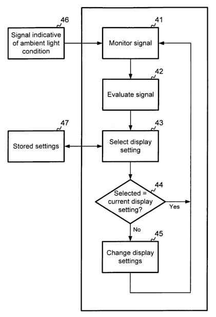
Figure 4 is a flowchart illustrating the present invention. The navigation
device stores in
its memory various data that is required to perform navigation related
functions. The
data might comprise map data, satellite data, user data, sound and text ftles,
software for
navigation and related operations, also configuration ftles, preference
settings and
operating system files. The memory can be one of a random access memory, a
hard disk,
a flash memory, a removable memory card, and any suitable volatile or non-
volatile
storage means. The processor of the navigation device is connected to the
memory and
performs various operations as and when they are required based on programmed
instructions and/or user interaction. The processor may carry out read and
write
operations. The processor is able to delete, move and modify data in any
manner that is
required for the operation of the navigation device.
8
CA 02643724 2008-08-26
WO 2007/101711 PCT/EP2007/002137
In the first step of Figure 4, the processor of the navigation device monitors
for a signal
indicative of ambient lighting conditions. In this embodiment, the signal is
received from
a light sensor mounted on a printed circuit of the navigation device.
A light sensor is a photosensitive diode or transistor producing an output
signal that is a
function of the amount of light impinging the surface of the diode. When the
relation
between the amount of light on the diode and the corresponding output signal
is known,
it is possible to reliably distinguish between various lighting conditions
such as daylight
and night or, optionally, to use a finer granularity for further
distinguishing between an
arbitrary number of transitional lighting conditions between daylight and
night.
Manufacturers of light sensors publish respective operating characteristics of
diodes such
as the TOSHIBA TPS851 model, which may be used in this implementation of the
invention. In other implementations, it is also possible that the light sensor
is coupled
externally to the navigation device, and it is also possible that the sensor
is only capable
of distinguishing between two conditions and providing an output signal
indicating one
of the two conditions. Other sensors indicative of current lighting conditions
might be
used, such as a headlight status indicator to give a good estimation that
outside light
levels have decreased when the vehicle headlights are on.
In the first step, the processor of the navigation device monitors a signal
indicative of
current lighting conditions. In the next step, the processors performs an
evaluation of
the signal and then proceeds to selecting an appropriate display setting that
has been
allocated for the current lighting condition. The processor proceeds to
changing current
display settings to the selected display setting after it has determined that
the current
display setting differs from the setting allocated to the current lighting
condition.
The allocated display setting might comprise one of the color schemes that has
been
discussed above, and might also comprise pre-set backlight levels, and
optionally
showing or hiding details on the screen.
A display setting suited for daylight conditions may comprise a screen
backlight level set
to a maximum value, and a color scheme using realistic day-like colors, and
showing map
information in a similar fashion than on paper maps.
9
CA 02643724 2008-08-26
WO 2007/101711 PCT/EP2007/002137
Another display setting for use during the night may comprise a lowered
backlight level
which can be in the lower half of the backlight range, e.g. set to 15 percent,
in
combination with the same color scheme as above or another color scheme using
colors
that are similar to a view of the area surrounding the user at night. It is
also possible that
the color scheme for nighttime usage employs inverted colors of the color
scheme for
daytime usage.
It is also possible that a night view indicates objects that are not visible
during the day,
e.g. stars, streetlight, and it is also possible to configure a night view to
disable some
objects or functions that are more likely to be relevant during the day and
enable
functions that might be relevant to the user of the navigation device during
the night or
in dark environments. Thus, besides using a pre-defined set of colors for
displaying
screen contents, a day or night view might show different pieces of
information, which
might include at least one of a star map, points of interests, information on
map items or
planned route, and menu items. A day or night view might also enable or
disable some
functions of the navigation device, which might be at least one of a speed
limit warning,
a driving break warning, and updating of traffic or weather information.
Therefore, when
switching to a day or night view, the navigation device will retrieve
information on road
conditions, such as congestion or road temperatures and si.milar.
In the following, attention is drawn to Figures 4, 5, and 6 that describe
various
configuration options for the user of the navigation device.
Figure 5 is a screen shot from a preferences menu of a navigation device. The
menu is
based on various icons and text labels, each of the icons representing a
different
configuration option. On some navigation devices, configuration options can be
reached
through a menu based purely on text.
Icon 51 in the lower left hand corner is labeled "Change map colours" and by
selecting
it, the user of the navigation device can select map colors that are most
appropriate for
the current operating environment or other parameters, like the personal
preference of
the user. Some color schemes have been designed to create a more realistic
representation of the actual view, while others are adopted for color blind
persons, and
still others are designed around various themes, such as the official colors
of a country's
CA 02643724 2008-08-26
WO 2007/101711 PCT/EP2007/002137
national soccer team. Certain color schemes conform to regional differences in
color
coding of paper maps and road infrastructure objects.
It is common in color schemes of the present invention that any objects that
might be
displayed on the screen have an association with a color. The color
associations in a color
scheme might be pre-defined and fixed, or it might be possible for the user of
the
navigation device to select colors for individual map objects and elements
displayed on
the screen.
According to this embodiment of the invention, certain map colors are more
suited for
daytime use, and others are suited for nighttime use. The user can manually
link one
color scheme to daytime use and link a different color scheme to nighttime
use, or the
appropriate day and night color schemes can be stored as a factory preset in
the memory
of the navigation device. Icon 52 in the lower center area of the preferences
menu opens
up a brightness preferences screen that will be described in more detail in
Figure 6.
Figure 6 depicts a screen shot of a brightness preferences menu of a
navigation device
according to the invention. The screen shot indicates a fttst slider 61 for
selecting a
backlight level to be used during daytime, and slider 62 for selecting another
backlight
level to be used during nighttime. The backlight levels can be selected
independently
fxom each other or as a ratio of each other. In the example shown on Figure 6,
daytime
backlight level is at 90 percent of the available range, and nighttime
backlight level is at
15 percent of the range. Alternatively, the user may indicate a desired ratio,
e.g. daytime
brightness 90 percent of the available range, and a nighttime brightness being
15 percent
of selected daytime brightness. It is also possible that the user of the
navigation device
wishes to use a higher backlight level during the night than during the day.
It is possible
by setting sliders 61 and 62 accordingly.
On the lower part of Figure 6, checkboxes 63 and 64 have been indicated.
Checkbox 63
is marked when the user wishes to rely on the navigation device to adjust
backlight of the
display between the two levels as may be selected by sliders 61 and 62. When
checkbox
63 is deselected, the user will be able to set backlight levels manually.
Checkbox 64 is
marked when the user of the navigation device wishes to rely on the navigation
device to
switch between day and night color schemes according to a mechanism
illustrated in
11
CA 02643724 2008-08-26
WO 2007/101711 PCT/EP2007/002137
Figures 8 and 9. When the user deselects checkbox 64, the navigation device
keeps using
the current color scheme independently of the lighting conditions.
Figure 7 illustrates the configuration menu of a navigational device, wherein
the user can
manually switch between day and night colors using button 71. When a nighttime
display
setting is selected by pressing this button, checkboxes 63 and 64 (of Figure
6) will not be
taken into account by the navigation device.
Figure 8 is a transition diagram illustrating various display settings of the
navigation
device in response to different lighting conditions. The horizontal axis 1
represents the
level of the input signal received from a light sensor. When the input signal
indicates low
ambient lighting conditions, i.e. the input is below a threshold 2, the
navigation device
uses a night color scheme and a nighttime display setting. When the input from
the light
sensor indicates daytime lighting conditions, i.e. signal level is higher than
threshold 2,
the navigation device uses a day color scheme and a daytime display setting.
Threshold 2
has been set to a value corresponding to an ambient light level, below which
the average
user would be using a night color scheme. Threshold 2 can be factory preset or
it can be
set by the users of the navigation device according to their personal
preferences.
The vertical axis 4 represents the screen brightness between 0 to 100
percents. In this
example, daytime brightness 5 is set to 100 percent, and nighttime brightness
6 is set to
approximately 25 percent. Nighttime brightness 6 is used as long as the light
sensor input
is below threshold 2, and daytime brightness 5 is used when the light sensor
input is
above threshold 3.
In another embodiment, threshold 2 and threshold 3 are identical, i.e. co-
located at a
point on horizontal axis 1. In this case, the display settings instantly
change from
nighttime brightness to daytime brightness when the signal indicative of
ambient lighting
conditions rises above the combined threshold 2 and 3. Similarly, when the
signal
30. indicative of ambient lighting conditions falls below the combined
threshold 2 and 3,
display settings instantly change from daytime brightness to nighttime
brightness.
Figure 8 depicts a smooth transition along line 7 between levels for nighttime
brightness
6 and daytime brightness 5 while the light sensor input is between threshold 2
and
12
CA 02643724 2008-08-26
WO 2007/101711 PCT/EP2007/002137
threshold 3 that are set to different values of the horizontal axis 1. In this
case, further
display settings might be allocated to different parts of the transition line
7. The further
display settings might be created using daytime color schemes and gradually
changing
backlight levels; or nighttime color schemes and gradually changing backlight
levels.
In the preferred implementation, 5 different backlight levels are allocated
evenly between
the levels for nighttime brightness 6 and daytime brightness 5, without
changing the
color scheme. This arrangement provides a gradual dimming of display backlight
in
response to the decreasing ambient light levels. In this example, four points
2A, 2B, 2C,
and 2D are shown on the horizontal axis 1 between threshold 2 and threshold 3.
There
might be a different number of points, the points might be placed arbitrarily
between
thresholds 2 and 3 or they may be evenly distributed.
When the signal indicative of ambient lighting conditions falls to threshold 3
on the
horizontal axis 1, screen brightness is decreased to a value associated with
threshold 2D,
which lays proportionally between the value of daytime brightness 5 and
nighttime
brightness 6 (in this example, 100 and 25 percents respectively). Screen
brightness
remains at the value associated with threshold 2D until the decreasing signal
actually
reaches threshold 2D. At threshold 2D, screen brightness changes to the value
associated
with threshold 2C; and screen brightness remains unchanged until the
decreasing signal
actually reaches threshold 2C. Similarly, at threshold 2C, screen brightness
changes to the
value associated with threshold 2B; and at threshold 2B, screen brightness
changes to the
value associated with threshold 2A. Finally, at threshold 2A, screen
brightness changes to
the value associated with threshold 2, which is the value of nighttime
brightness 6; and
screen brightness remains unchanged as long as the signal is below threshold
2. Changing
from daytime colors to rughttime colors can occur at one of thresholds 2, 2A,
2B, 2C,
2D, and 3, depending on factory or user configuration.
Similarly, when the signal level on the horizontal axis 1 rises in response to
increasing
ambient light levels, the navigation device is configured to change from
nighttime color
schemes to daytime color schemes at threshold 2, and to gradually increase
display
backlight from nighttime brightness level to daytime brightness level along
line 7 until
light sensor input indicative of ambient lighting conditions reaches threshold
3. The
detailed procedure is the following.
13
CA 02643724 2008-08-26
WO 2007/101711 PCT/EP2007/002137
Screen brightness remains at the level of nighttune brightness 6 as long as
the signal
indicative of ambient lighting conditions is below point 2A, or alternatively
threshold 2.
When a raising signal reaches threshold 2A, screen brightness changes to a
level allocated
to this given point, which is a proportional value and can be read from the
vertical axis 2,
somewhere between nighttime brightness 6 and daytime brightness 5 (in this
example, 25
and 100 percents respectively). At threshold 2B, screen brightness increases
to a level
allocated to this given point and thereafter it remains unchanged until the
signal reaches
threshold 2C. Screen brightness keeps changing in a similar manner at
thresholds 2C and
2D. Finally, at and above threshold 3, daytime brightness 5 is used, which is
equal to 100
percent in this example.
In the above examples, there are four transition points between nighttime
brightness 6
and daytune brightness 5, providing a good granularity without the need to
store a high
number of settings. In other implementations, any larger or smaller number of
transitional steps can be used or there can be a step less, continuous
transition as well.
Above threshold 3, daytime display settings are used unless the user of the
navigation
device manually selects a different display setting, e.g. by pressing button 1
on Figure 7 to
use night colors, or by disabling checkboxes 3 and 4 on Figure 6. In other
implementations, different configuration options might be available for
manually
disabling the switching between day and night color schemes. The user might
simply
select the same color scheme and same backlight level for daytime and
nighttime usage in
order to disable any automatic change.
Figure 9 indicates an altered transition diagram compared to Figure 8. On
Figure 9, the
level of daytime brightness 5 has been lowered to a new daytime brightness 5',
the
difference is indicated by arrow 9. Nighttime brightness 6 has been changed to
a new
nighttime brightness 6', the difference is indicated by arrow 10. The new
configuration
can be compared to the previously discussed transition line 7 as seen on new
transition
line 7'. Using new transition line 7', the steps between new nighttime
brightness 6' and
new daytime brightness 5' are smaller but the transition is still a smooth,
gradual one as
long as threshold 2 and 3 are not the same.
14
CA 02643724 2008-08-26
WO 2007/101711 PCT/EP2007/002137
In the above examples, ambient lighting conditions are measured using a light
sensor
coupled to the processor of the navigation device. The light sensor can be an
integral
part of the navigation device or it may be an external sensor attached to a
suitable
connector of the navigation device or its docking unit.
In other arrangements, the external sensor might transmit radio signals such
as Bluetooth
or Infra-Red signals indicative of ambient lighting conditions. For example, a
radio signal
transmitter might be directly or indirectly connected to an in-vehicle light
sensor or
headlight sensor and configured to transmit radio signals to the navigation
device, the
signals being indicative of ambient lighting conditions. The proper
installation of a
Bluetooth or Infra-Red transmitter unit is known to a person skilled in the
art and it is
outside the scope of the invention. A Bluetooth or Infra-Red enabled
navigation device
may monitor radio signals indicative of ambient lighting conditions and
implement the
invention according to the appended claims.
In the absence of a signal from a light sensor or a similar hardware
component, or in
addition to it, the software on the navigation device may also monitor the
current
position of the navigation device and compare it to the map data for the
purposes set out
above. By matching map data to current position, the software of the
navigation device
may indicate that the current position is in a tunnel or in an underground car
park, which
is interpreted as a signal indicative of low ambient lighting conditions. Lack
of position
data (i.e. loss of GPS signal) might also indicate that the current location
is in a tunnel or
underground car park.
In that case, indication of ambient lighting conditions does not require a
hardware
component implemented on or coupled to the navigation device. The signal
indicative of
lighting conditions can be generated using software means such as at least one
of a map
data, user data, time data and configuration data.
In a further embodiment, the navigation device might ask for a confirmation
from the
user before or after changing between day and night color schemes upon
determination
that current display setting is not the display setting allocated to current
ambient lighting
conditions. A selection screen or a confirmation dialog may be presented to
the user of
the navigation device for changing display settings.
CA 02643724 2008-08-26
WO 2007/101711 PCT/EP2007/002137
When the navigation device is removed from the vehicle, i.e. when it is
detected that the
device has been undocked, the user may select further options, which comprise
at least
one of a confirmation of undocking, a selection whether or not to monitor a
signal
indicative of lighting conditions, selection of color scheme to be used, and
selection of
backlight level to be used. A similar. selection is possible when docking the
navigation
device in the vehicle.
The invention has been described with reference to certain preferred
embodunents. It
will be understood, however, that modifications and variations are possible
within the
scope of the appended claims.
16