Note: Descriptions are shown in the official language in which they were submitted.
CA 02645180 2008-09-08
WO 2007/108623 PCT/KR2007/001324
Description
HEXAGONAL ROADWAY SYSTEM AND TRAFFIC CONTROL
SYSTEM THEREOF
Technical Field
[1] The present invention relates to the urban roadway system and accompanying
un-
derground railway system, which provide the efficient use of limited
constructible
areas of the congested cities, and also relates to the traffic flow control
system capable
of the effective control of vehicular movements through the roadways.
Background Art
[2] Using tools and machines, human beings customarily made things out of
lines and
tetragons. And furthermore, for thousands years they have filled their
surrounding
spaces with the artifacts shaped in rectangles except in the case for
incidental
ornaments. Densely populated cities have been so constructed with the roadways
inter-
connecting the main places of their districts directly as to have many
crossroads. All
the traffic problems caused by the expanded supply of automobiles have been
regarded
as the inevitable products of modern civilization. So far as every
intersection of a con-
ventional roadway system is concerned, it has been problematic even for a
highly
advanced computer system to establish a complete traffic flow control system
which
should combine 12 traffic-lines plus bi-directional 4 crosswalks.
[3] Meanwhile, nature pursues circles (in 2-dimensional planes) and spheres
(in
3-dimensional spaces). But no perfect circles and spheres exist because of the
effect of
external forces. In such a realm of nature, the structure of a snowflake or a
honeycomb
comprises many hexagon cells. The most efficient forming out of the cohesion
of
identical circles in a plane is exactly the hexagonal net structure like a
honeycomb.
This is the result of a transformation that the gaps between mutually
Circumscribed
circles were thrust and shrunken by the dominant external forces applied.
[4] By means of applying the hexagonal net structure found from one of
nature's
phenomena to mankind's customary societies from the dawn of civilization,
creating
more efficient urban spaces is to be the technological secret of the present
invention.
Disclosure of Invention
Technical Problem
[5] When humans move in the spaces with intersecting lines over planes of
artificial
polygons, there always exist the ineffective parts of times and spaces which
decrease
the efficiency of movement. On this point of view, the times and spaces of
necessary
evils, both of which are required for operating the vehicular media that are
not the best
means for the physical movements of humans, are defined to be ineffective
times and
2
WO 2007/108623 PCT/KR2007/001324
ineffective spaces , respectively.
[6] The kernel of the present invention is to find technical solutions through
analyzing
those ineffective times and spaces quantitatively with respect to the
properties of two
different types of the urban roadway systems proposed as follows.
[7] A typical roadway network configured and connected in the tetragonal net
structure
is defined to be the tetragonal roadway system , and likewise, the other is
defined to
be the bexagonal road way system. Assuming two different types of cities,
defined
herein as the tetra-city and the bexa-city, which correspond to the respective
roadway
systems mentioned above, the present invention provides solutions to the
following
three main problems.
[8] First : To derive the method for reducing ineffective spaces of urban
areas through
renovating the structure of roadway networks.
[9] Second : To derive the method for reducing ineffective times of urban
areas
through renovating the structure of roadway networks.
[10] Third : To establish the technical basis to obtain economical and
political validity
and fairness in governmental city planning with regards to the overall
renovation of
the urban spaces including public facilities over and under ground, in
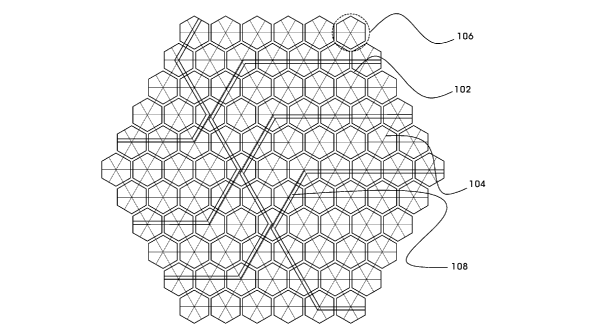
accordance with
the renewal of the roadways.
Technical Solution
[11] In the whole or partial areas of the city to which the present invention
is applied, the
roadway network is constructed and connected in the net structure of hexagonal
meshes like the cross-section of a honeycomb. Inside each hexagonal unit-block
(abbreviated as block , hereinafter) surrounded by inter-block roads
constituting the
roadway network mentioned above, inner-block roads and other architectural
facilities are placed. And ortbogonal roads, circular roads and other local
roads
constitute the group of inner-block roads mentioned above.
[12] The areas divided by the inner-block roads are allocated for buildings or
facilities,
which are suitable for the topographic or geographic properties of the block,
and the
roads beside them are connected to the respective circular roads. The central
land of
the block can be provided for a plaza, park, school site, library, or other
facilities of
public use.
[13] As represented in FIG. 1, each orthogonal road (104) connects the central
part of a
block (106) with those of other adjacent blocks, and intersects the
corresponding inter-
block roads (102). The circular roads (not depicted) of a block are arranged
in the ap-
propriate intervals one another, and intersect the respective orthogonal roads
of the
same block.
[14] Each crosswalk (or pedestrian crossing) of the hexa-city, being on the
inter-block
CA 02645180 2008-09-08
3
WO 2007/108623 PCT/KR2007/001324
roads, are allowed to equip with a mid-safety island for pedestrian's time-lag
crossing
(Refer to FIG. 5).
[15] Underground railways (108) are installed under the orthogonal roads with
possible
entrance of two different lines of the railways on the parallel lines of a
platform in a
station. And stations for them are built under a central plaza or a certain
intersection of
crossroads (Refer to FIG. 1).
[16] The tetra-city divides the lanes of a road into three directions as left,
forward and
right, while the hexa-city divides into two as left and right. Accordingly,
the numbers
of lanes required between the two cities are in the ratio of 3:2, i.e. simply,
the lane ratio
is 3/2. The reasonable allocation of lanes of roads has become the key to the
traffic
policy of the traditional tetra-city.
[17] Relying on the regulations of determinations, structures, and
installation standards
for facilities of urban planning (the ordinance #414 of the ministry of
construction and
transportation, republic of Korea), the articles for roads are as follows
(extracted and
abstracted).
[18] Article 9-2. Sort of roads by width
[19] a. Wide road: 40 meters or more, 12 lanes or more
[20] b. Large road: 25 meters or more, 8 lanes or more
[21] c. Medium road: 12 meters or more, 4 lanes or more
[22] d. Small road: Others
[23] Article 9-3. Sort of roads by functional grade
[24] Main arterials, auxiliary arterials, collectors, local roads, etc
[25] Article 10. Placement distance forRoads of a grade
[26] Stepped down respectively by grade: 1000, 500, 250, 125, 60, 25 (meters).
[27] Article 11. Road ratio according to zoning, adjustable when demanded
[28] 1. Residential zone: 20% to 30%, including 10% to 15% of main arterials
[29] 2. Commercial zone: 25% to 35%, including 10% to 15% of main arterials
[30] It has been widely recognized that the road ratio trades off the traffic
flow for the
land usage. But the radical problem concerning the road ratio of the tetra-
city is being
unable to get out of the structural limit, which requires lanes in the ratio
of 3:2, even
though simply compared with a hexa-city.
[31] Therefore, the upper-limit values of the respective road ratios mentioned
above,
which would minimize the degree of traffic congestion of the tetra-city, are
herein
quoted to analyze the road ratios of the two different cities.
[32] The criterion of the road ratio of the tetra-city is presumed to be 32.5%
that is the
arithmetic mean value of the two upper-limit road ratios of the most congested
zones,
both of which are the main targets to apply the present invention. The
assigned road
ratios to main-arterials, auxiliary-arterials and inner-block roads are 12%,
8%, and
CA 02645180 2008-09-08
4
WO 2007/108623 PCT/KR2007/001324
12.5%, respectively (from the sum 32.5%).
[33] The above-mentioned values were determined through minute analysis on the
relevant regulations of the current ordinances for the tetragonal roadway
system. (The
sum of the road ratios of arterials was rounded off as 20%, though calculated
as
20.28%.)
[34] Setting up the road ratio of the tetra-city is equivalent to the
presumption that the
uniform expansion of the four sides of a tetragon block with 0 road width (no
road
areas) makes as much outer area as the portion of the road ratio. In every
numerical ex-
pressions, hereinafter, 4N is defined as the square root of N, and
4{expression} as the
square root of the expression.
[35] 4{100/(100-32.5)} x100%=121.7%
[36] When the side lengtb ratio is defined as the ratio between the side
lengths of two
different regular-polygon blocks of equal effective area, the side-length
ratio of a tetra-
city to a hexa-city is 43 (about 1.732). The side length of 540meters of the
tetra-city
corresponds to that of about 312meters of the hexa-city. The diameter of
inscribed
circle of each block is identical as 540meters in this example (Refer to FIG.
3 and FIG.
4).
[37] In addition, under the assumption that the road width is proportional to
the
placement distance of roads as quoted in the Article 10, the proper numbers of
traffic
lanes for the respective road grades are set as below.
[38] Placement distance (m): 1000, 500, 250, 125, 60, 25 (reduced by 1/2 per
step)
[39] Grade index (lanes): 12, 10, 8, 6, 4, 2 (reduced by 2 lanes/step)
[40] The road ratio of main arterials is in proportion to the road width and
the perimeter
of the block, and the road width is in proportion to the number of lanes and
the grade
index according to the block's side length. Therefore, the road ratio of main
arterials of
hexa-city to tetra-city can be written as
[41] Road ratio of main arterials of tetra-city x road-width ratio (LIR lane
ratio x GI
R grade index ratio) x P/R perimeter ratio, that is
[42] 20%x(2/3)x((8+((10-8)x(289-250)/(500-250)))/10)x(6x(1/~3)/4)=9.6%
[43] L/R G/R P/R
[44] On account of the profitable structure of the hexa-city, the lanes of
each inner-block
road can be assigned simply to the two, forward or right, of three kind of
traffic-lines
except lanes for left. Accordingly, the inner-block road ratio of hexa-city
can be
written as below.
[45] Inner-block road ratio of tetra-city x lane ratio x perimeter ratio, that
is
[46] 12.5%x(2/3) x (6x (1/43)/4)=7.2%
[47] Conclusively, the side-expansion ratio, determined by the sum 16.8% of
road ratio
of hexa-city, can be calculated as follows.
CA 02645180 2008-09-08
5
WO 2007/108623 PCT/KR2007/001324
[48] 4{100/(100-16.8)}x100%=109.6%
[49] Above assumptions are applied to the following proposition 1.
[50] Proposition 1. The respective areas of a circle of diameter of 2 (in anv
units ). both
regular-hexagon and regular-tetragon. circumscribing the circle, are about
3.14(=z x1 xl ). 3.46(=2V3) and 4.
[51] Then, the following are derived.
[52] Proportional area of tetra-city including roads: 4x(1.217x1.217)=5.92
[53] Proportional area of hexa-city including roads: 3.46x(1.096x1.096)=4.16
[54] Area ratio of tetra-city to hexa-city: 5.92/4.16=1.42
[55] Ineffective area ratio of tetra-city: (5.92-3.14)/3.14x 100%=89%
[56] Ineffective area ratio of hexa-city: (4.16-3.14)/3.14x100%=32%
[57] Ineffective area ratio of tetra-city to hexa-city: 89/32=2.78
[58] Proportional road area of tetra-city: 5.92-4= 1.92
[59] Proportional road area of hexa-city: 4.16-3.46=0.70
[60] Road area ratio of tetra-city to hexa-city: 1.92/0.70=2.74
[61] Conclusively, the tetra-city contains ineffective spaces, constructible
areas and road
areas at the respective ratios of 2.78 (36.0%, in reverse), 1.43 (70.0%, in
reverse) and
2.74 (36.4%, in reverse) as compared with the hexa-city.
[62] Vehicles and pedestrians of the tetra-city always take detours out of
tetragonal
corners, which cause unpredictable vehicular contacts and pedestrian contacts.
The
greater problem is that the ineffective spaces are transmitted to the dark
backside so as
to speed up increasing slums.
[63] And next, to compare the average extent (length) of roadways between the
two
cities, the proposition 2 is introduced.
[64] Proposition 2. The respective perimeters of a circle of diameter of 2 (in
any
units), both regular-hexagon and regular-tetragon. circumscribing the circle,
are
about 6.28(=2z). 6.93(=12/113) and 8.
[65] Also, the following is obtained.
[66] Roadway extent ratio of tetra-city: 8x1.217=9.74
[67] Roadway extent ratio of hexa-city: 6.93x1.096=7.60
[68] Therefore, the vehicles of the tetra-city take detours on the long
roadways of the
ratio of about 1.28 (78.1%, in reverse) to those of hexa-city.
[69] In a 4-way intersection of the tetra-city, the traffic control system
processes 12
traffic-lines, 3 lines (left-turn/ forward/right-turn) per way, in a signal-
cycle . And In a
3-way intersection of the hexa-city, it processes 6 traffic-lines, 2 lines
(left-turn/right-turn) per way, in a signal-cycle.
[70] As the ratio of traffic-lines is 12:6 and the ratio of needed lanes per
roadway is
about 2:1, as is often the case that lanes for right-turn are neglected, tetra-
city requires
CA 02645180 2008-09-08
6
WO 2007/108623 PCT/KR2007/001324
4 times longer signal-cycle than the hexa-city.
[71] The optimum solution to the traffic control system is defined as the
system which
allows a group of vehicles to pass the consecutive intersections without
stopping
regardless of driving distance and direction on the roadway network under the
unified
traffic controls.
[72] Though an optimum solution to the traffic control system for the tetra-
city does not
exist, there exist the solution for the hexa-city that has the equivalently
symmetric
roadway network.
[73] Under the following prerequisite conditions, the present invention proves
the
existence of the optimum solution for the unitarybexagonal roadway network
(abbreviated as road-net , hereinafter) under the unified traffic control
system of the
hexa-city. A section is defined as a segment of the inter-block road between
the two
adjacent 3-way intersections.
[74] Condition 1. Every inter-block road of the road-net contains at least 2
lanes per
way (or side of a roadway), and each intersection contains 3 different inter-
block
roads.
[75] Condition 2. Each intersection, except in outskirts or borderlands of the
road-net,
is connected with three adjacent intersections of a kind through above-
mentioned
inter-block roads.
[76] Condition 3. The course of a vehicle toward a distant destination is
completed
through alternating turns between left and right at each intersection.
[77] Condition 4. In order to change or amend the direction of above-mentioned
course, exceptional turns against condition 3 can be selected.
[78] Condition 5. The signal-cycle on every intersection of the road-net is
identical,
and 1 signal-cycle consists of 3 signal-units.
[79] Condition 6. The allowable speed for vehicles and the length of signal-
cycle are
adjustable to cover 2 sections per signal-cycle.
[80] Condition 7. Each crosswalk (or pedestrian crossing) can be equipped with
mid-
safety island for pedestrian's time-lag crossing.
[81] Under the above seven conditions, passing two sections in a signal-cycle
makes
vehicles repeat identical traffic condition. Passing two sections in a signal-
cycle is
equivalent to passing 2/3 sections in a signal-unit.
[82] The order of left-turn for each traffic-line on an intersection complies
with the
traffic-line numbers, counterclockwise (Refer to FIG. 5). Though each
intersection
contains three different roads, a pair of traffic-lines running on either side
of a roadway
has the same traffic-line number (Refer to FIG. 6).
[83] The hexagonal roadway network, differs from the tetragonal roadway
network,
every one of the 6 traffic-lines exclusively occupies its own lane (or lanes)
in an in-
CA 02645180 2008-09-08
7
WO 2007/108623 PCT/KR2007/001324
tersection (Refer to FIG. 6).
[84] The unique method for the optimal traffic flow controls is as follows. By
one and
one sequence for the three pairs of traffic lines, the vehicles of each pair
of traffic-lines
simultaneously pass overall intersections of unitary roadway network with left-
turn
during a signal-cycle (Refer to FIG. 7).
[85] The three adjacent intersections to a certain intersection, which is
occupied by the
left-turning traffic-line, are occupied by the reverse traffic-line of the
same pair. Con-
currently, the vehicles of other pairs of traffic-lines are running on other
roads or
passing intersections with right-turn (Refer to FIG. 7).
[86] With the above-mentioned system of signal synchronization on the unitary
roadway
network, it is possible for a group of vehicles to pass intersections
alternately in a
signal-cycle without stopping.
Advantageous Effects
[87] Ceaseless widening of roads in conventional tetra-cities comes from the
fact
supposing the road-capacity for entering cars during congestion of an
intersection. The
increase of traffic lanes forces drivers to choose one of the lanes. However,
drivers are
used to choose the middle lanes unintentionally. For such a reason, assigning
more
middle lanes causes the lack of left or right lanes, which results in another
traffic
problem. As the signal lights turn on in an intersection, changing lanes
occurs between
vehicles of other directions, and leads to the vicious circle of accumulative
congestion.
[88] The 3-way intersections of hexa-city not only eliminate all the hazardous
elements
of tetra-city, but also enhance the traffic efficiency by reducing the length
of a signal-
cycle approximately to 1 minute from 3 minutes of conventional crossroads.
Drivers
can choose lanes single-mindedly and, with broader fields of view while
crossing in-
tersections, make smoother traces of about 60 degree turning angle, which
provides
almost constant running speed without slowdown cornering. On the other hand,
pedestrians can cross the roads safely during a sufficient time longer than a
half of the
signal-cycle without vehicular hindrance.
[89] Symmetrically arranged six-side, six-bent inter-block roads induce
vehicles to
scatter spontaneously, and congestions can be absorbed within each block by
assigning
the most crowded facilities of public use to the central area. As vehicles
have to stop
and park somewhere on the inner-block roads, the disruptions between vehicles
are
remarkably decreased. Two remote spots on a hexagonal roadway network can be
in-
terconnected at the least distance of geometrical equality when compared with
any
other roadway networks, and vehicles on the roadway can pass the consecutive
in-
tersections without meeting any stop signals through the traffic control
system of
signal synchronization.
CA 02645180 2008-09-08
8
WO 2007/108623 PCT/KR2007/001324
[90] Therefore, hexa-cities eliminate the need of circumventing freeways which
cause a
new traffic problem of frequent jams around their interchanges or junctions.
[91] As two different lines of underground railways installed along the
orthogonal roads
can come parallel on a floor of a station, passengers can transfer at the same
platform.
[92] The fluent curvatures of roadways and railways reduce frictional losses
and
consuming energies due to the de/acceleration of vehicles. The reduction of
travel time
and stopping frequency of vehicles enhance the efficiency of traffic, and pro-
portionally, the life span of vehicles and roadways can also be prolonged, and
urban
pollution can be reduced enormously in result
[93] All the hexagonal blocks of hexa-cities have six penetrating orthogonal
roads
allowing better atmospheric circulation. The hexagonal blocks and roads can
easily
adapt to the non-rectangular, curved boundary of a city, hence make them ideal
for de-
velopment in environment-friendly way by significantly reducing the amount of
con-
struction work of straight roads.
[94] The hexa-city innovates the conventional urban planning of vain attempt
to solve
the traffic congestions with raising the road ratio through widening roads.
The hexa-
city significantly reduces the Earthly resources wasted on the ineffective
times and
spaces of tetra-cities. Most of all, the present invention will convert human
activities
for personal exchanges from wide-road oriented outward-dispersion to central-
plaza
oriented inward-concentration, and thus the modern civilization of mankind
will
forever continue into the era of culture.
Brief Description of the Drawings
[95] FIG. 1 shows the basic concept of the present invention. It shows each
hexagonal
block divided and surrounded by inter-block roads, orthogonal roads drawn as
solid
lines and subways drawn as (shaded) double lines. Circular roads and
arrangements of
buildings are omitted for simplicity. The orthogonal roads do not intersect at
the center
of each block actually, but they are drawn so to help understand the concept.
[96] FIG. 2 shows a constitution of an example city in accordance with an
embodiment
of the present invention. It illustrates that the widths of roads and the
sizes of blocks
can be enlarged, reduced, or modified if required.
[97] FIG. 3 and FIG. 4 show that each side of a polygonal block is expanded
uniformly
as much outer area as the portion of the block's road ratio.
[98] FIG. 5 shows a 3-way intersection of the inter-block roads and the order
of left-turn
between the three traffic-limes (denoted with numbers 1, 2, and 3,
respectively).
[99] FIG. 6 shows the turning positions on the roadways occupied fixedly,
exclusively
by the three pairs of traffic-lines before passing each intersection.
[100] FIG. 7 shows the status of roadways just when 3/4 of one signal-unit
elapsed after
CA 02645180 2008-09-08
9
WO 2007/108623 PCT/KR2007/001324
the left-turn of the traffic-line number 1 proceeds. Each triangle represents
a 3-way in-
tersection, and a small circle represents the crosswalk with the go-signal
turned on.
[101] The Legends of the figures are as follows.
[102] 102: inter-block road 104: orthogonal road
[103] 106: unit-block 108: underground railway
[104] 500: intersection 502: crosswalk
[105] 504: mid-safety island of a crosswalk 506: signal light
Best Mode for Carrying Out the Invention
[106] The average size of blocks of a hexa-city can be determined in
accordance with the
scale of urban areas and the degree of congestions of the city. Assuming each
section
of the length of 450 meters and the vehicular speed of 50-70 kilometers per
hour on
the inter-block roads, It takes about 60 seconds to cover two sections
o900meters.
Therefore, the signal-unit is 60 divided by three, namely 20 seconds.
[107] As a group of vehicles, passing a 3-way intersection during one signal-
unit at the
average speed of 60 kilometers per hour without meeting stop-signals, makes up
the
extent of near 300 meters, the traffic volume per intersection of the hexa-
city can be
estimated. On the other hand, as the vehicles of the two traffic-lines
competing lanes of
a roadway are always apart more than 1/2 signal-unit, the vehicles of a
traffic-line can
occupy all of the lanes for an interval before and after passing the
intersection. The
traffic control system of the hexa-city should be established on the basis of
those
inferences (Refer to FIG. 7).
[108] During the left-turn of each traffic-line of a roadway, the go-signals
of the two
adjacent crosswalks of the other side of the roadway are turned on and
pedestrians can
cross the road half by half through the mid-safety island for a sufficient
time of 2
continuous signal-units in a signal-cycle. The pedestrians' waiting time at
the mid-
safety island is 0 or 0.5 signal-unit depending on the direction of crossing.
Vehicles
waiting for U-turning or coming out of the block can proceed their ways during
near
1.5 signal-units.
[109] The location and scale of the u-turn zone can be specified according to
the fact that
vehicles running on the inter-block road gradually disappear from the center
to either
end of both sides of a section during one signal-cycle.
[110] Meanwhile, vehicles on the orthogonal road, waiting to cross the inter-
block road,
proceed their ways as well as the pedestrians can cross the road to move to
the opposite
block during 1.5 signal-units.
Mode for the Invention
[111] The description so far is just an exemplified explanation for the
technological
principles of the present invention, and various modifications are possible
within the
CA 02645180 2008-09-08
10
WO 2007/108623 PCT/KR2007/001324
substantial properties of the present invention. Consequently, the examples
deployed
by the present invention are for the explanation of the technological
principles, not for
confining. The protection boundary of the present invention should be
interpreted
according to the following claims, and the present invention should be
interpreted as to
include all the equivalent technical concepts.
Industrial Applicability
[112] Enhancing the efficiency of the use of lands, the hexa-city can obtain
about 30 % of
saved land area in comparison to the tetra-city of the identical effective
area. The hexa-
city can be realized in newly constructed cities as well as in existing tetra-
cities
through long-term, divisional redevelopment or partial restructuring of
existing
roadway networks. Just like a tetra-city, the hexa-city also contains straight
roads such
as the orthogonal roads intersecting inter-block roads and interconnecting the
central
parts of the adjacent blocks (Refer to FIG. 1). Projecting to search for areas
convertible
into 3-way intersections on the city map through overlapping the parallel
roads of the
tetra-city and the corresponding orthogonal roads of a direction, the plan to
convert
into hexa-city with minimum construction overheads could be established.
[113] Through such conversion, the following innovations on the urban planning
and de-
velopment can be expected.
[114] First : Rezoning to convert the existing broad roads into newly
developed series of
urban areas in accordance with the urban planning is possible.
[115] Second : Upward equalization on the urban development is possible on
account of
rising of the under-developed backside areas to the central places of 3-way in-
tersections.
[116] Third : Converting the extra areas created by the reduction of
ineffective areas
into the environmental, economical value is possible.
CA 02645180 2008-09-08