Note: Descriptions are shown in the official language in which they were submitted.
CA 02645927 2008-09-09
WO 2008/051236 PCT/US2006/043885
Geospatially Aware Vehicle Security
RELATED APPLICATIONS
[0001] This application claims the benefit of Provisional Patent Application
Serial No.
60/735,416, entitled "Vehicle Security," filed November 9, 2005, which is
incorporated
herein by reference.
BACKGROUND
1. FIELD OF THE INVENTION
[0002] The present invention relates generally to vehicle security, and more
specifically, to remote vehicle control informed by geospatial awareness.
2. DESCRIPTION OF THE RELATED ART
[0003] For individual vehicle owners and fleet owners alike, vehicle security
is a
rapidly growing concern. Fleet owners have even greater sensitivity to this
issue, stemming
from homeland security concerns, especially for trucks that carry hazardous
materials and/or
very valuable goods. One concern for vehicle owners is hijacking, alone, or in
conjunction
with threats to various structures, e.g., government buildings or landmarks.
In addition,
owners of vehicles that follow an authorized route, e.g., for product
deliveries, require a level
of security to ensure that the vehicle drivers do not substantially divert
from their planned
routes. A vehicle in motion presents dual concerns: how to safely bring the
vehicle under
control and how to prevent rogue vehicles from being used to cause intentional
damage or
harm to people and/or property.
1
CA 02645927 2008-09-09
WO 2008/051236 PCT/US2006/043885
[0004] Therefore, there is a need for a system and method that provides
vehicle security
combined with geographical awareness.
SUMMARY
[0005] In various embodiments, the present invention provides methods and
systems
for controlling a vehicle in conjunction with geospatial awareness. According
to the
methods_ vehicle locations are tracked and Analv7Pd fnr rnmr~lianrP ~x~ith mtP
CPta
corresponding to specific geographic locations. Some rules state that a
vehicle maintain a
minimum distance from a location, e.g., a national monument, and other rules
state that a
vehicle not exceed a maximum distance from a location, e.g., a point on an
approved route.
If one or more rules is violated, a speed control command is issued to the
vehicle in violation.
Speed control commands include speed reduction commands, vehicle shutdown
commands,
and combinations of speed reduction and vehicle shutdown commands.
[0006] The description in the specification is not all inclusive and, in
particular, many
additional features will be apparent to one of ordinary skill in the art in
view of the drawings,
specification, and claims. Moreover, it should be noted that the language used
in the
specification has been principally selected for readability and instructional
purposes, and may
not have been selected to delineate or circumscribe the inventive subject
matter.
BRIEF DESCRIPTION OF THE DRAWINGS
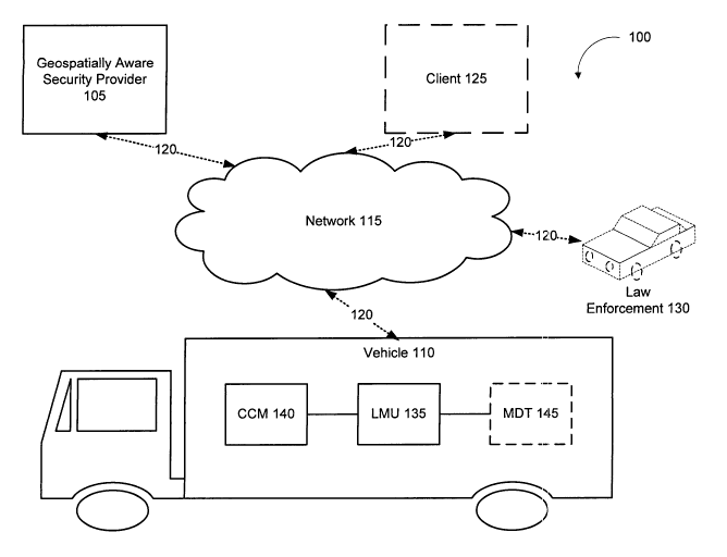
[0007] FIG. 1 is a block diagram illustrating the relationship between various
entities
involved in a geospatially aware security system in accordance with one
embodiment of the
present invention.
2
CA 02645927 2008-09-09
WO 2008/051236 PCT/US2006/043885
[0008] FIG. 2 is a flowchart illustrating a method of controlling a vehicle
that violates a
rule corresponding to a geographically-sensitive location according to one
embodiment of the
present invention.
[0009] FIG. 3 is a flowchart illustrating a method of implementing a speed
control
command according to one embodiment of the present invention.
[0010] FIGS. 4A and 4B illustrate examples of geo-fence regions according to
various
embodiments of the present invention.
[0011] FIG. 5 is a block diagram illustrating geospatially aware security
provider
software according to one embodiment of the present invention.
[0012] One skilled in the art will readily recognize from the following
discussion that
alternative embodiments of the structures and methods illustrated herein may
be employed
without departing from the principles of the invention described herein.
DETAILED DESCRIPTION OF THE EMBODIMENTS
[0013] FIG. 1 is a block diagram illustrating the relationship between various
entities
involved in a geospatially aware security system 100 in accordance with one
embodiment of
the present invention.
[0014] The geospatially aware security system 100 includes at least a
geospatially
aware security provider 105 and at least one vehicle 110, which communicate
via a network
115, e.g. a wireless network. The system 100 may include more than one vehicle
100,
however, FIG. 1 shows only one vehicle 110 for clarity of explanation. The
geospatially
aware security provider 105 exchanges messages with the vehicle 110 and
provides
3
CA 02645927 2008-09-09
WO 2008/051236 PCT/US2006/043885
sophisticated data-driven message processing capabilities. The processing
capabilities are
utilized to provide monitoring, managing, reporting, and notifying
functionality, e.g., to one
or more clients 125. For example, in one embodiment the geospatially aware
security
provider 105 provides functionality for monitoring and managing a fleet of
trucks I 10 on
delivery routes. The geospatially aware security provider 105 processes
messages from the
trucks 110 to perform functions such as determining whether trucks 110 are on
schedule,
whether trucks 110 have deviated from assigned routes, whether the trucks 110
are speeding,
etc.
[0015] The one or more vehicles 110 exchange messages with the geospatially
aware
security provider 105 as described above. The vehicles 110 may be any known
type of
mobile transportation device. The vehicle 110 includes components to support
the messaging
capability, for example, a location management unit (LMU), as described in
greater detail
below.
[0016] The network 115 may be any type of network, including wireless
networks. The
network 115 may be the Internet, or other network embodiments, such as a LAN,
a WAN, a
MAN, a wired or wireless network, a private network, a virtual private
network, or other
systems allowing for data communication between two or more computing systems.
The
network 115 enables communication between the geospatially aware security
provider 105
and the vehicle 110.
[0017] In conjunction with the various network types, the connections 120
between the
entities and the network 115 may take various configurations. In one
embodiment, the
vehicle 110 uses conventional cellular wireless communication technologies to
exchange
messages with the geospatially aware security provider 105, including cellular
telephone
technologies using the cell control channel, code division multiple access
(CDMA), general
4
CA 02645927 2008-09-09
WO 2008/051236 PCT/US2006/043885
packet radio service (GPRS), satellite-based communication technologies, etc.
The vehicle
110 can also use conventional wireless computer networking technologies, such
as 802.11, to
communicate with the geospatially aware security provider 105. In other
embodiments, the
vehicle 110 utilizes satellite-based communication technologies, non-cellular
based radio
communication technologies, and/or other technologies. Communication between
the vehicle
110 and the geospatially aware security provider 105 is preferably bi-
directional and the
vehicle 110 and geospatially aware security provider 105 can utilize different
technologies
for different directions of communication.
[0018] In addition to the geospatially aware security provider 105 and
vehicle(s) 110,
one or more clients 125 may be included in the geospatially aware security
system 100. The
client 125 may be a person, computer system, application, or other entity that
communicates
with the geospatially aware security provider 105 to access and/or participate
in the
monitoring, managing, reporting, and/or notifying functionalities. The
geospatially aware
security provider 105 and client 125 can communicate via a variety of
technologies and
interfaces. For example, the client 125 can communicate with the geospatially
aware security
provider 105 using a telephone-based interactive voice response (IVR)
interface, a web page-
based interface, an email interface, data exchanged via a network connection
utilizing the
TCP/IP, and/or a dedicated application interface. The client 125 can utilize a
variety of
devices to access these interfaces, including a telephone, computer system,
pager, etc. These
communications can utilize conventional wired and/or wireless data and/or
voice
communications links. Although only one client 125 is shown in FIG. 1,
embodiments of the
system 100 have many clients 125.
[0019] Another optional aspect of the system 100 includes law enforcement 130.
As
described herein, law enforcement involvement may include the geospatially
aware security
CA 02645927 2008-09-09
WO 2008/051236 PCT/US2006/043885
provider 105 and/or client 125 notifying law enforcement of the location of
the target vehicle,
visual confirmation of a vehicle by law enforcement, e.g., for confirming a
vehicle speed
control command.
[0020] The vehicle 110 further includes a location management unit (LMU) 135,
a
component control module 140, and optionally a mobile data terminal 145.
[0021] The LMU 135 acts as a tracking device for the vehicle 110 according to
one
embodiment. The LMU 135 is a device that is physically attached to the vehicle
110, and
thus the LMU 135 and the vehicle 110 are assumed to be at the same location at
any given
point in time, so that the location of the LMU 135 is a proxy for the location
of the mobile
asset itself. For this reason, this description sometimes treats the LMU 135
and the vehicle
110 as the same entity.
[0022] In general, the LMU 135 supports position determination and position
reporting.
In one embodiment, the LMU 135 provides position determination by having a
conventional
sensor adapted to use the satellite-based Global Positioning System (GPS) to
determine the
LMU's 135 current longitude, latitude, altitude, heading, velocity, etc. In
other embodiments,
an LMU 135 uses other position determination systems, such as an inertia-based
tracking
system, the Galileo satellite navigation system, a cellular telephone tower or
television signal
triangulation system, and/or an assisted GPS system such as the wide area
augmentation
system (WAAS). Different LMUs 135 in the system 100 can use different position
determination systems.
[0023] One embodiment of the LMU 135 includes a processor and memory and is
adapted to execute program code modules for generating messages. The LMU 135
is
6
CA 02645927 2008-09-09
WO 2008/051236 PCT/US2006/043885
responsible for implementation of a speed control command received at the
target vehicle
110.
[0024] The vehicle 110 also includes at least one component control module
(CCM)
140 according to one embodiment. The CCM 140 receives the vehicle component
command
from the LMU 135, and is responsible for implementing the command. The CCM 140
can
include any number of various vehicle controls and components.
[0025] According to one embodiment, the CCM 140 is a three-phase signal
interrupt for
turbo diesel engine vehicles, and the vehicle component command includes a
first instruction
to disrupt a turbo boost signal, a second instruction to disrupt a throttle
signal, and a third
instruction to disrupt the ignition.
[0026] In another embodiment, the CCM 140 is a vehicle bus, e.g., using the
Society of
Automotive Engineers (SAE) J1708 standard, and the vehicle component command
comprises an instruction to limit target vehicle speed. In yet another
embodiment, the
component control module is an electronically/digitally actuated fuel valve,
and the vehicle
component command includes an instruction to restrict fuel flow. In this
example, the
electronically/digitally actuated fuel valve is electronically actuated and
controlled by the
LMU 135, as described herein. The process uses an RS232/485 or TTL interface
to restrict
the flow of fuel according to these examples.
[0027] In yet another embodiment, the CCM 140 also includes a braking system.
[0028] According to one embodiment, the CCM 140 provides for easy
installation, for
example, by use of a pre-made wiring harness that goes inline with the various
vehicle
component lines (throttle line, brake line, etc.).
7
CA 02645927 2008-09-09
WO 2008/051236 PCT/US2006/043885
[0029] The vehicle 110 optionally includes a mobile data terminal (MDT) 145
according to one embodiment. The MDT 145 is a device that allows display and
input
capabilities inside the vehicle 110, e.g., by the vehicle driver. The MDT 145
may have basic
or advanced computing capabilities. For example, the messages received by the
LMU 135,
including alerts may display on the MDT 145 in 'some embodiments. In one
embodiment, the
MDT 145 requires the vehicle driver to login to the vehicle 110 before the
vehicle 110 will
start.
[0030] FIG. 5 is a block diagram illustrating geospatially aware security
provider
software 500 according to one embodiment of the present invention. The
geospatially aware
security provider software 500 includes a location module 510, an analysis
module 520, and a
command module 530.
[0031] The location module 510 enables determination of the location of a
target
vehicle according to one embodiment. In one embodiment, this includes
receiving messages
about a target vehicle.
[0032] The analysis module 520 enables analysis of the location of the target
vehicle
against a set of rules corresponding to allowed distances between the target
vehicle and one
or more geographically-sensitive locations. For example, rules may include
minimum
distances that a vehicle must be from locations, or may include maximum
distances that a
vehicle is allowed to deviate from its scheduled route/path.
[0033] The command module 530 enables issuance of a speed control command is
issued to the target vehicle, responsive to a determination that a rule
corresponding to a
selected geographically-sensitive location has been violated by the target
vehicle. The
command module 530 further enables additional safeguard steps according to
various
8
CA 02645927 2008-09-09
WO 2008/051236 PCT/US2006/043885
embodiments, for example to confirm a vehicle for the speed control command.
In one
embodiment, a secured request is first initiated. The command module 530
further enables
issuing a speed control command as a series of steps and/or alert levels
according to one
embodiment. The command module 530 further enables issuing a speed control
command
that is a speed reduction command, which includes a set of instructions for
reducing the speed
of the target vehicle, and/or a vehicle shutdown command, which includes
instructions for
gradually bringing the target vehicle to a complete stop.
[0034] FIG. 2 is a flowchart illustrating a method of controlling a vehicle,
e.g., 110, that '
violates a rule corresponding to a geographically-sensitive location according
to one
embodiment of the present invention. As described in greater detail below, a
rule is violated
when the condition corresponding to the rule evaluates false.
[0035] The method begins by determining 210 a location of a target vehicle 110
according to one embodiment. In one embodiment, this step includes receiving
messages
about a target vehicle I 10. The target vehicle may be selected, for example,
from a plurality
of monitored vehicles. In one embodiment, the target vehicle 110 is a rogue
vehicle, e.g., a
vehicle that has been hijacked or otherwise has left control of its owner.
[0036] The target vehicle is tracked in conjunction with a location management
unit
(LMU) 135 installed in or otherwise attached to the target vehicle according
to one
embodiment. The LMU 135 and the target vehicle 110 are assumed to be at the
same
location at any given point in time, so that the location of the LMU 135 is a
proxy for the
location of the target vehicle I 10 itself. The LMU 135 provides for position
determination
and position reporting to the provider 105, using GPS or other position
determination
systems, as described herein. In one embodiment, the LMU 135 provides position
reporting
using functionality for sending electronic messages reporting the LMU's
position. For
9
CA 02645927 2008-09-09
WO 2008/051236 PCT/US2006/043885
example, the LMU 135 may be configured to send messages at certain intervals,
such as
every 5 minutes or every day. In another embodiment, the LMU 135 is configured
to send
the messages upon the occurrence of one or more events, such as when the LMU's
rate of
acceleration exceeds a predetermined limit, when the LMU 135 moves a certain
distance,
when a vehicle I 10 door is unlocked, and/or when the LMU 115 has moved within
a certain
distance of a predetermined or geographically-sensitive location. According to
one
embodiment, the LMU 135 is responsible for receiving the speed control
command,
translating the speed control command into a vehicle component command,
transmitting the
vehicle component command to a component control module 140, and monitoring
the
component control module for implementation of the vehicle component command,
as
described in greater detail below. According to another embodiment, the LMU
135 includes
component control module functionality, such that it directly controls vehicle
components.
[0037] The messages generated by the LMU 115 preferably contain data
describing
aspects of the associated target vehicle, such as location information
describing the current
location of the vehicle, whether it has deviated from its assigned route,
whether the vehicle is
speeding, etc. The LMU 135 may be used in conjunction with the MDT 145 in some
embodiments, e.g., to display messages and alerts, and/or to allow the vehicle
driver to login
to the vehicle 110 before it will start.
[0038] Next, the location of the target vehicle 110 is analyzed 220 against a
set of rules
corresponding to allowed distances between the target vehicle I 10 and one or
more
geographically-sensitive locations. The set of rules may include rules
specific to the target
vehicle 110, and/or may include rules generic to all monitored vehicles or
monitored vehicles
of the same type as the target vehicle I 10. For example, rules may include
minimum
distances that a vehicle must be from locations such as national landmarks,
government
CA 02645927 2008-09-09
WO 2008/051236 PCT/US2006/043885
buildings, bridges, events centers, tunnels, etc., e.g., for vehicles
containing hazardous
materials. Also, rules may include maximum distances that a vehicle is allowed
to deviate
from its scheduled route/path, e.g., for vehicles transporting high-value
contents. An
exemplary rule is that a vehicle stay within 10 miles of its authorized path.
Thus, when the
corresponding condition - is the vehicle within 10 miles of its authorized
path - evaluates
true, i.e., the vehicle is within 10 miles of its authorized path, the rule is
satisfied; when the
condition evaluates false, i.e., the vehicle is more than 10 miles outside of
its authorized
path, the rule is violated.
[0039] Selected geographically-sensitive locations may be contained within geo-
fences
that define allowed distances between vehicles 110 and the various selected
geographically-
sensitive locations. A geo-fence is defined as a geographic region. For
example, a list of
geo-fences may be maintained, e.g., by the geospatially aware security
provider 105. A geo-
fence is preferably defined by one or more geometric constructs, such as
points, lines, arcs,
polygons, circles, etc. Each construct is preferably associated with a
geographic location,
such as a latitude and longitude, thereby establishing a geo-fence region. If
a geo-fence is
defined as a circle, for example, the geo-fence region preferably identifies
the latitude and
longitude of the center, and the distance of the radius. Similarly, if a geo-
fence is defined by
a polygon, the geo-fence region preferably identifies the latitudes and
longitudes of the end
points of each side of the polygon. A geo-fence region can be three-
dimensional. If, for
example, a geo-fence is defined by a sphere, the geo-fence region preferably
identifies a
center of the sphere at a latitude, longitude, and altitude and a radius of a
given distance from
the center of the sphere.
[0040] Thus, using the location information received in step 210, that
location can be
analyzed against the rules, includirig the region information, to see if any
rule has been
11
CA 02645927 2008-09-09
WO 2008/051236 PCT/US2006/043885
violated. In addition, the location information may be used for additional
reasons over the
rule analysis described below, e.g., for notifying law enforcement, e.g., 130,
of the location of
the target vehicle 110.
[0041] Various rules may apply, as described above, which may be satisfied or
violated.
For example, in one embodiment, a rule is violated by a target vehicle
exceeding a maximum
allowed distance from a selected geographically-sensitive location. In another
embodiment, a
, = , , ., _,1 ----- 1 1"-`--- -- r ---- -
n~iP .vi_.,ni.... atPn nv a TaraPi vPm---ri-P ua----Piiin--uc c -- in- c~r
rnan a minimi~m ai~i-wriii~in~~~e kiinii a
._....~ .,.....-a^ =-----
selected geographically-sensitive location.
[0042] Responsive to a determination that a rule corresponding to a selected
geographically-sensitive location has been violated by the target vehicle 110,
a speed control
command is issued 230 to the target vehicle.
[0043] Issuing a speed control command may include additional safeguard steps,
for
example to confirm a vehicle for the speed control command. In one embodiment,
a secured
request is first initiated. The initiation process is enabled by the
geospatially aware vehicle
security provider 105 according to one embodiment, and the process may be
controlled by the
client alone or in conjunction with the provider 105. For example, the request
may be
secured by requiring an authenticated login by the client 125, or a user
associated with the
provider 105, before allowing the request to proceed. Then, the execution of
the secured
request may be confirmed. Various methods exist for confirming the request,
e.g., to prevent
unauthorized use of the system. In one embodiment, law enforcement is
involved. For
example, the confirmation may include visual identification by law
enforcement, e.g., by a
police officer following the target vehicle. In this example, the police
officer provides his
identification information, e.g., name and badger number, and the target
vehicle identification
information, e.g., license plate number or company vehicle identifier to the
client 125 and/or
12
CA 02645927 2008-09-09
WO 2008/051236 PCT/US2006/043885
provider 105. The information may be provided electronically via an interface
in the police
vehicle, via telephone, or by any other transmission means. Once the law
enforcement visual
is processed, the request can be executed.
[0044] According to another embodiment, the confirmation is via a manual
override.
For example, the manual override may be used when officer identification is
not available for
various reasons or is not necessary. In this example, the authorized user
confirms the manual
nx7Pr1'1l1P en t11at tnP cnPPl1 (`nnrrni rnmmAnlt rAtl Il! tranemittPll
[0045] Issuing a speed control command may include a series of steps and/or
alert
levels according to one embodiment. For example, if a vehicle 110 is
approaching a
minimum allowed distance from a geographically-sensitive location, a first
level alert may be
issued. The alert may issue to the vehicle 110 directly, or may issue to the
entity monitoring
the vehicle according to various embodiments. For example, a message may issue
to a client
125 according to various methods, such as email, SMS, IVR, webpage or web
display, or
other alert mechanism. In addition, the first level alert may include
adjusting the minimum
allowed distance from the geographically-sensitive location.
[0046] For example, when a rule corresponding to a geographically-sensitive
location
has been violated by a vehicle 110, e.g., a geo-fence boundary has been
crossed, an action is
triggered. Actions may be triggered by moving from inside a geo-fence region
to outside a
geo-fence region, or from outside a geo-fence region to inside a geo-fence
region. Geo-
fences may be hard geo-fences or soft geo-fences. A hard geo-fence is set and
recognized by
a moving device, e.g., by an LMU 135 on a vehicle 110. In this example, hard
geo-fences are
crossed, and an action triggered, when the device moves into or out of the geo-
fence region.
A soft is set and recognized on a server, e.g., at the geospatially aware
security provider 105.
In this example, soft geo-fences are crossed, and an action triggered, when
data arrives at the
13
CA 02645927 2008-09-09
WO 2008/051236 PCT/US2006/043885
server that demonstrates that the status of a device, or vehicle, has changed.
Data may arrive
at the server at scheduled intervals, for example, as part of the messaging of
the LMU 105 as
described herein. Thus, adjusting the minimum allowed distance from the
geographically-
sensitive location may include adjusting a geo-fence region, e.g., making the
geo-fence
region smaller or larger.
[0047] Diagrams showing examples of geo-fence regions are shown in FIGS. 4A
and
~ .1 1
uR in iir i 4H a uPnuTan1 mcN~~v-cCnclil"vr. 1incililnn AA4ul in rmc exHmnie
il fj~lVr.rri~Yir.rii
---1 c--a---------
--------- - -- -------- ~ -- , --- ----- -------r-- -- o- -------
building, is shown. Initially, a geo-fence region 410 corresponding to a
boundary 415 is
exists surrounding the geographically-sensitive location 405, as shown by a
solid circle. In
this example the geo-fence region is circular; however, geo-fences may take
various other
configurations as described herein. If a vehicle 420 (not shown to scale)
crosses the
perimeter or boundary 415 of the geo-fence 410, an alert may be issued. Also,
the geo-fence
boundary 415 may be adjusted according to some embodiments. For example, the
boundary
415 of the geo-fence 410 may be tightened to a smaller geo-fence 425,
surrounded by an
adjusted boundary 430, shown by a dashed circle. If the vehicle 4201ater
crosses the
adjusted geo-fence boundary 430, a second alert may be triggered, as described
below. For
example, the first geo-fence boundary 415 may have been a few miles from the
geographically-sensitive location 405, and the adjusted boundary 430 may be
less than one
mile from the geographically-sensitive location 405, to allow for time to slow
or stop the
vehicle before it reaches the geographically-sensitive location 405, depending
on vehicle
speed.
[0048] A second example shows a geographically-sensitive location 450 that
corresponds to an approved route 455 for a vehicle 460 as shown in FIG. 4B. In
this
example, each point 465 along the route 455 is a geographically-sensitive
location at various
14
CA 02645927 2008-09-09
WO 2008/051236 PCT/US2006/043885
times during the truck's journey along the route 455. As the geographically-
sensitive
location 450 moves along the route 455 in conjunction with vehicle movement, a
geo-fence
470 bound by a geo-fence boundary 475 accompanies it, a shown by the solid
circle. In this
example, if the vehicle 4601eaves the geo-fence region 470, an alert may be
triggered, and/or
a wider geo-fence 480 and accompanying boundary 485 may be established, as
shown by the
dashed line.
ililiLlui OttPr t11P f1rCt IPVPI aiPrt ie iccnPlt iT thP VPh1nIP rnni1n11PC nn
an 11ni171TYlnri7Pl1
Lvv ai J . ._.v. ...v _..v. .v . v_ ..... _.. _vv ....., _ ...v . v...v.v
vv...........v ..-- -- -- .--~--"....
route, an additional alert level may apply. For example, if a vehicle is
approaching an
adjusted minimum allowed distance from a geographically-sensitive location, a
second level
alert may issue. In this example, the second level alert may include issuing
the speed control
command. These steps and alerts are only examples, other variations on the
number and
types of alerts that may be used are within the scope of the present
invention.
[0050] The speed control command may be any one of various types. According to
one
embodiment, the speed control command is a speed reduction command, which
includes a set
of instructions for reducing the speed of the target vehicle 110. For example,
the speed
reduction command may include a maximum speed threshold. In this example, the
speed of
the target vehicle is reduced until the maximum speed threshold is reached, at
which time the
threshold speed is maintained. In addition, the instructions may include more
than one
threshold speed, for gradual stepwise speed reduction of the target vehicle
110, if desired.
Used alone, the speed reduction command may allow for increased safety, e.g.,
if the vehicle
is moving at excessive speed relative to its location, provide for gradual
reduction of speeds
in high-speed areas, e.g., on a highways, or may assist law enforcement in
apprehension of
the vehicle 110.
CA 02645927 2008-09-09
WO 2008/051236 PCT/US2006/043885
[0051] According to another embodiment, the speed control command is a vehicle
shutdown command. The command includes instructions for gradually bringing the
target
vehicle to a complete stop. In some embodiments, the speed control command may
include
both speed reduction and vehicle shutdown elements, with instructions for
reducing the speed
of the target vehicle 110 before bringing it to a complete stop.
[0052] In yet another embodiment, the speed control command includes an
instruction
tn Chntllnii/n thP tArOPt vPllirip i i A iY it rnmPc tn a etnn P Q at nn
inTPreP!`tinn i Ylic
instruction may be used in combination with the speed reduction and vehicle
shutdown
commands, as described above for a vehicle 110 in motion.
[0053] The speed control command can be implemented in various ways by the
vehicle
controls and components. A general method of implementing the speed control
command is
shown in the FIG. 3.
[0054] The implementation method begins when a speed control command is
received
310 at a target vehicle 110. For example, the speed control command may be
received 310 at
the LMU 135 for the target vehicle 110 via wireless protocol from the
geospatially aware
security provider 105 or client 125 over a wireless network, e.g., 115.
[0055] Next, the speed control command is translated 320 into a vehicle
component
command. This aspect of the present invention allows for the message received,
which may
be in one format, to be processed by one or more vehicle components, which may
process
messages of a different format. The translation takes into consideration the
nature of the
component control module, and provides the necessary message translation. In
one
embodiment, the LMU 135 provides the translation functionality.
16
CA 02645927 2008-09-09
WO 2008/051236 PCT/US2006/043885
[0056] Once translated 320, the vehicle component command is transmitted 330
from
the LMU 135 to a CCM 140 for implementation. The component control module 140
can be
any number of various vehicle controls and components.
[0057] According to one embodiment, the CCM 140 is a three-phase signal
interrupt for
turbo diesel engine vehicles, and the vehicle component command includes a
first instruction
to disrupt a turbo boost signal, a second instruction to disrupt a throttle
signal, and a third
inernirrinn Tn riicnini inP ioniiinn in inic Pxamnin inc~ i~irnn nnnci ciun;~i
lirci i~ iiiqn7nieii_
- .,.~.,__ _., ---- -'r- ---- -o------- --- ----- -------r------ ------ -----
--o----- ----- -- -------r ----~
causing less horsepower to be generated by the engine, thus reducing the
maximum speed of
the vehicle. Then, the throttle input signal is disrupted, the electronic
control of the turbo
diesel engine will return automatically, or with an added idle switch, to an
idle state.
Although the vehicle will eventually come to a stop using this method,
steering and braking
mechanisms remain intact. Finally, the ignition is disrupted, causing the
engine to turn off.
[0058] In another embodiment, the component control module 140 is a vehicle
bus,
e.g., using the Society of Automotive Engineers (SAE) J1708 standard, and the
vehicle
component command comprises an instruction to limit target vehicle speed. In
yet another
embodiment, the component control module 140 is electronically/digitally
controlled fuel
valve, and the vehicle component command includes an instruction to restrict
fuel flow. In
this example, the electronically/digitally controlled fuel valve is
electronically actuated and
controlled by a Location Management Unit (LMU), as described herein. The
process uses an
RS232/485 or TTL interface to restrict the flow of fuel according to two
examples.
[0059] In yet another embodiment, the component control module 140 also
includes a
braking system, and the vehicle component command further comprises an
instruction to
apply the braking system.
17
CA 02645927 2008-09-09
WO 2008/051236 PCT/US2006/043885
[0060] Finally, the component control module 140 is monitored 340 for
implementation
of the vehicle component command. The monitoring may take place as part of the
vehicle
system, may be eternal to the vehicle 110, e.g., law enforcement monitoring,
or a
combination thereof. In one embodiment, the monitoring includes monitoring
target vehicle
110 speed to confirm the target vehicle 110 has reached a maximum speed
threshold.
[0061] The present invention has been described in particular detail with
respect to one
- TL___ _i _1_:11 L_ 4L.. ..-___:11 ]_=_ L_4 ~L,. :.....,....a:,. ,...., L,.
1)UN111)IC Cllll)1I111111G11L - IIl/lG Ul Jlllll lll L11G a1L W111
duUlGl;IA.IG ulaL Lllc ulvGUUVU ulav UG
a
practiced in other embodiments. First, the particular naming of the
components,
capitalization of terms, the attributes, data structures, or any other
programming or structural
aspect is not mandatory or significant, and the mechanisms that implement the
invention or
its features may have different names, formats, or protocols. Further, the
system may be
implemented via a combination of hardware and software, as described, or
entirely in
hardware elements. Also, the particular division of functionality between the
various system
components described herein is merely exemplary, and not mandatory; functions
performed
by a single system component may instead be performed by multiple components,
and
functions performed by multiple components may instead performed by a single
component.
[0062] Some portions of above description present the features of the present
invention
in terms of algorithms and symbolic representations of operations on
information. These
algorithmic descriptions and representations are the means used by those
skilled in the data
processing arts to most effectively convey the substance of their work to
others skilled in the
art. These operations, while described functionally or logically, are
understood to be
implemented by computer programs. Furthermore, it has also proven convenient
at times, to
refer to these arrangements of operations as modules or by functional names,
without loss of
generality.
18
CA 02645927 2008-09-09
WO 2008/051236 PCT/US2006/043885
[0063] Unless specifically stated otherwise as apparent from the above
discussion, it is
appreciated that throughout the description, discussions utilizing terms such
as "determining"
or "displaying" or the like, refer to the action and processes of a computer
system, or similar
electronic computing device, that manipulates and transforms data represented
as physical
(electronic) quantities within the computer system memories or registers or
other such
information storage, transmission or display devices.
r....~.~ rr_ _C~l__ ~' ~~. ~l__,1,. 4 .7 n~... ..1;
IIIIIN41 l,CTIil1I1 i1.1'I)C1:11 lll LIIC l)IGIGIIL IIIVGIILI~III I11li1LLLLG
UrVVCJJ JIGUJ CL11U 11J11UVUV1IJ
described herein in the form of an algorithm. It should be noted that the
process steps and
instructions of the present invention could be embodied in software, firmware
or hardware,
and when embodied in software, could be downloaded to reside on and be
operated from
different platforms used by real time network operating systems.
[0065] The present invention also relates to an apparatus for performing the
operations
herein. This apparatus may be specially constructed for the required purposes,
or it may
comprise a general-purpose computer selectively activated or reconfigured by a
computer
program stored on a computer readable medium that can be accessed by the
computer. Such
a computer program may be stored in a computer readable storage medium, such
as, but is
not limited to, any type of disk including floppy disks, optical disks, CD-
ROMs, magnetic-
optical disks, read-only memories (ROMs), random access memories (RAMs),
EPROMs,
EEPROMs, magnetic or optical cards, application specific integrated circuits
(ASICs), or any
type of media suitable for storing electronic instructions, and each coupled
to a computer
system bus. Furthermore, the computers referred to in the specification may
include a single
processor or may be architectures employing multiple processor designs for
increased
computing capability.
19
CA 02645927 2008-09-09
WO 2008/051236 PCT/US2006/043885
[0066] The algorithms and operations presented herein are not inherently
related to any
particular computer or other apparatus. Various general-purpose systems may
also be used
with programs in accordance with the teachings herein, or it may prove
convenient to
construct more specialized apparatus to perform the required method steps. The
required
structure for a variety of these systems will be apparent to those of skill in
the, along with
equivalent variations. In addition, the present invention is not described
with reference to any
particular programming language. It is appreciated that a variety of
programming languages
may be used to implement the teachings of the present invention as described
herein, and any
references to specific languages are provided for invention of enablement and
best mode of
the present invention.
[0067] The present invention is well suited to a wide variety of computer
network
systems over numerous topologies. Within this field, the configuration and
management of
large networks comprise storage devices and computers that are communicatively
coupled to
dissimilar computers and storage devices over a network, such as the Internet.
[0068] Finally, it should be noted that the language used in the specification
has been
principally selected for readability and instructional purposes, and may not
have been
selected to delineate or circumscribe the inventive subject matter.
Accordingly, the disclosure
of the present invention is intended to be illustrative, but not limiting, of
the scope of the
invention, which is set forth in the following claims.