Note: Descriptions are shown in the official language in which they were submitted.
CA 02649439 2011-08-16
50866-19
DYNAMIC RESERVOIR ENGINEERING
mooll
BACKGROUND
[0002] Operations, such as surveying, drilling, wireline testing,
completions,
production, planning and field analysis, are typically performed to locate and
gather valuable downhole fluids. Surveys are often performed using acquisition
methodologies, such as seismic scanners or surveyors to generate maps of
underground formations. These formations are often analyzed to determine the
presence of subterranean assets, such as valuable fluids or minerals, or to
determine whether the formations have characteristics suitable for storing
fluids.
[0003] During the drilling, completions, production, planning and field
analysis
operations, data is typically collected for analysis and/or monitoring of the
operations. Such data may include, for instance, information regarding
subterranean formations, equipment, historical and/or other data.
[0004] Data concerning the subterranean formation is collected using a
variety of
sources. Such formation data may be static or dynamic. Static data relates to,
for
example, formation structure and geological stratigraphy that define
geological
structures of the subterranean formation. Dynamic data relates to, for
instance,
fluids flowing through the geologic structures of the subterranean formation
over
1
CA 02649439 2012-08-15
50866-19
time. Such static and/or dynamic data may be collected to learn more about the
formations and the valuable assets contained therein.
[0005] Various equipment may be positioned about the field to monitor
field
parameters, to manipulate the operations and/or to separate and direct fluids
from the
wells. Surface equipment and completion equipment may also be used to inject
fluids into reservoirs, either for storage or at strategic points to enhance
production of
the reservoir.
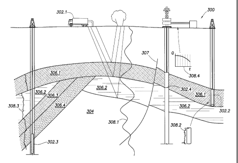
SUMMARY
[0006] According to one aspect of the present invention, there is
provided a
method for performing reservoir engineering that includes generating a
geological
model of a reservoir including a geological horizon, obtaining an offset
relative to the
geological horizon, and positioning a wellbore equipment item in a well
completion
design based on the offset. The method further includes calculating an
absolute
position of the wellbore equipment item in the well completion design based on
the
offset and a location of the geological horizon in the geological model and
updating
the geological model to generate an updated location of the geological
horizon. The
method further includes updating the absolute position of the wellbore
equipment
item in the well completion design based on the offset and the updated
location of the
geological horizon and simulating a simulation case including the geological
model
and the well completion design after updating the absolute position of the
wellbore
equipment item.
[0006a] According to another aspect of the present invention, there is
provided
a reservoir engineering system, comprising: a geological model of a reservoir
comprising a geological horizon; a fluid modeling module comprising
functionality to
generate a visualization showing surfaces of constant composition or
saturation
pressure from a fluid and rock model of the reservoir; a well completion
design
module comprising functionality to position a wellbore equipment item in a
well
completion design based on an offset from the geological horizon and to
position a
2
I
CA 02649439 2012-08-15
50866-19 .
reservoir operation relative to the geological horizon in the well completion
design,
wherein the reservoir operation comprises at least one selected from a group
consisting of hydraulic fracturing, an oilfield perforation operation,
acidization, a
chemical treatment, and a cement squeeze; and a simulation case module
operatively connected to the fluid modeling module and the well completion
module
and comprising functionality to generate a simulation case comprising the
geological
model, the well completion design, and the fluid and rock model of the
reservoir.
[0006b] According to still another aspect of the present invention,
there is
provided a computer readable medium storing instructions for performing
reservoir
engineering, the instructions comprising functionality to: generate a
geological model
of a reservoir including a geological horizon; obtain an offset relative to
the geological
horizon; position a wellbore equipment item in a well completion design based
on the
offset; calculate an absolute position of the wellbore equipment item in the
well
completion design based on the offset and a location of the geological horizon
in the
geological model; update the geological model to generate an updated location
of the
geological horizon; update the absolute position of the wellbore equipment
item in the
well completion design based on the offset and the updated location of the
geological
horizon; and simulate a simulation case comprising the geological model and
the well
completion design after updating the absolute position of the wellbore
equipment
item.
[0007] Other aspects of reservoir engineering will be apparent from
the
following description and the appended claims.
2a
CA 02649439 2009-01-13
PATENT APPLICATION
ATTORNEY DOCKET NO 94.0I92-NP 09469/145002
BRIEF DESCRIPTION OF DRAWINGS
[0008] So that the above described features and advantages reservoir
engineering
can be understood in detail, a more particular description of reservoir
engineering,
briefly summarized above, may be had by reference to the embodiments thereof
that are illustrated in the appended drawings. It is to be noted, however,
that the
appended drawings illustrate only typical embodiments of reservoir engineering
and are therefore not to be considered limiting of its scope, for dynamic
reservoir
modeling may admit to other equally effective embodiments.
[0009] FIG. 1.1-1.4 depict a simplified, schematic view of a field having
subterranean formations containing reservoirs therein, the various operations
being
performed on the field.
[0010] FIG. 2.1-2.4 is a graphical depiction of data collected by the
tools of FIGS.
1.1-1.4.
[0011] FIG. 3 is a schematic view, partially in cross section of a field
having a
plurality of data acquisition tools positioned at various locations along the
field for
collecting data from the subterranean formations.
[0012] FIGS. 4.1-4.3 show schematic, 3D views of static models based on
the data
acquired by the data acquisition tools of FIG. 3.
[0013] FIG. 5 is graphical representation of a probability plot of the
static models
of FIG. 4.
[0014] FIGS. 6.1 and 6.2 are schematic diagrams depicting independent
systems
for generating dynamic reservoir models.
[0015] FIGS. 7.1 and 7.2 are schematic diagrams depicting integrated
systems for
generating dynamic reservoir models.
[0016] FIG. 8 depicts a unified system for generating dynamic reservoir
models.
3
CA 02649439 2009-01-13
PATENT APPLICATION
ATTORNEY DOCKET NO 94 0192-NP, 09469/145002
[0017] FIGS. 9.1 and 9.2 are flow charts depicting methods of performing
oilfield
operations.
[0018] FIG. 10 depicts a system for reservoir engineering.
[0019] FIG. 11 depicts the collection of fluid samples in the field.
[0020] FIGS. 12.1-12.4 depict flowcharts for performing reservoir
engineering.
[0021] FIG. 13 depicts a computing system into which implementations of
various
techniques described herein may be implemented in accordance with one or more
embodiments.
DETAILED DESCRIPTION
[0022] Presently embodiments of dynamic reservoir modeling are shown in
the
above-identified FIGS. and described in detail below.
In describing the
embodiments, like or identical reference numerals are used to identify common
or
similar elements. The FIGS. are not necessarily to scale and certain features
and
certain views of the FIGS. may be shown exaggerated in scale or in schematic
in
the interest of clarity and conciseness.
[0023] FIGS. 1.1-1.4 depict simplified, representative, schematic views of
a field
100 having subterranean formation 102 containing reservoir 104 therein and
depicting various oilfield operations being performed on the field. FIG. 1.1
depicts a survey operation being performed by a survey tool, such as seismic
truck
106.1, to measure properties of the subterranean formation. The survey
operation
is a seismic survey operation for producing sound vibrations. In FIG. 1.1, one
such sound vibration 112 generated by a source 110 reflects off a plurality of
horizons 114 in an earth formation 116. The sound vibration(s) 112 is (are)
received in by sensors, such as geophone-receivers 118, situated on the
earth's
surface, and the geophones 118 produce electrical output signals, referred to
as
data received 120 in FIG. 1.1.
4
CA 02649439 2009-01-13
PATENT APPLICATION
ATTORNEY DOCKET NO 94 0192-NP, 09469/145002
[0024] In response to the received sound vibration(s) 112 representative
of
different parameters (such as amplitude and/or frequency) of the sound
vibration(s) 112, the geophones 118 produce electrical output signals
containing
data concerning the subterranean formation. The data received 120 is provided
as
input data to a computer 122.1 of the seismic truck 106.1, and responsive to
the
input data, the computer 122.1 generates a seismic data output 124. The
seismic
data output may be stored, transmitted or further processed as desired, for
example
by data reduction.
[0025] FIG. 1.2 depicts a drilling operation being performed by a drilling
tool
106.2 suspended by a rig 128 and advanced into the subterranean formations 102
to form a wellbore 136. A mud pit 130 is used to draw drilling mud into the
drilling tools via flow line 132 for circulating drilling mud through the
drilling
tools, up the wellbore 136 and back to the surface. The drilling mud is
usually
filtered and returned to the mud pit. A circulating system may be used for
storing,
controlling or filtering the flowing drilling muds. The drilling tools are
advanced
into the subterranean formations to reach reservoir 104. Each well may target
one
or more reservoirs. The drilling tools are preferably adapted for measuring
downhole properties using logging while drilling tools. The logging while
drilling
tool may also be adapted for taking a core sample 133 as shown, or removed so
that a core sample may be taken using another tool.
100261 A surface unit 134 is used to communicate with the drilling tools
and/or
offsite operations. The surface unit is capable of communicating with the
drilling
tools to send commands to the drilling tools, and to receive data therefrom.
The
surface unit is preferably provided with computer facilities for receiving,
storing,
processing, and/or analyzing data from the oilfield. The surface unit collects
data
generated during the drilling operation and produces data output 135 which may
be stored or transmitted. Computer facilities, such as those of the surface
unit,
CA 02649439 2009-01-13
PATENT APPLICATION
A I I ORNEY DOCKET NO 94 0192-N P, 09469/145002
may be positioned at various locations about the oilfield and/or at remote
locations.
[0027] Sensors (S), such as gauges, may be positioned about the oilfield
to collect
data relating to various oilfield operations as described previously. As
shown, the
sensor (S) is positioned in one or more locations in the drilling tools and/or
at the
rig to measure drilling parameters, such as weight on bit, torque on bit,
pressures,
temperatures, flow rates, compositions, rotary speed and/or other parameters
of the
oilfield operation. Sensors (S) may also be positioned in one or more
locations in
the circulating system.
[0028] The data gathered by the sensors may be collected by the surface
unit
and/or other data collection sources for analysis or other processing. The
data
collected by the sensors may be used alone or in combination with other data.
The
data may be collected in one or more databases and/or transmitted on or
offsite.
All or select portions of the data may be selectively used for analyzing
and/or
predicting oilfield operations of the current and/or other wellbores. The data
may
be may be historical data, real time data or combinations thereof The real
time
data may be used in real time, or stored for later use. The data may also be
combined with historical data or other inputs for further analysis. The data
may be
stored in separate databases, or combined into a single database.
[0029] The collected data may be used to perform analysis, such as
modeling
operations. For example, the seismic data output may be used to perform
geological, geophysical, and/or reservoir engineering. The reservoir,
wellbore,
surface and/or process data may be used to perform reservoir, wellbore,
geological, geophysical or other simulations. The data outputs from the
oilfield
operation may be generated directly from the sensors, or after some
preprocessing
or modeling. These data outputs may act as inputs for further analysis.
6
CA 02649439 2011-08-16
50866-19
[0030] The data may be collected and stored at the surface unit 134. One
or more
surface units may be located at the oilfield, or connected remotely thereto.
The
surface unit may be a single unit, or a complex network of units used to
perform
the necessary data management functions throughout the oilfield. The surface
unit
may be a manual or automatic system. The surface unit 134 may be operated
and/or adjusted by a user.
[0031] The surface unit may be provided with a transceiver 137 to allow
communications between the surface unit and various portions of the oilfield
or
other locations. The surface unit 134 may also be provided with or
functionally
connected to one or more controllers for actuating mechanisms at the oilfield
100.
The surface unit 134 may then send command signals to the oilfield 100 in
response to data received. The surface unit 134 may receive commands via the
transceiver or may itself execute commands to the controller. A processor may
be
provided to analyze the data (locally or remotely), make the decisions and/or
actuate the controller. In this manner, the oilfield may be selectively
adjusted
based on the data collected. This technique may be used to optimize portions
of
the oilfield operation, such as controlling drilling, weight on bit, pump
rates or
other parameters. These adjustments may be made automatically based on
computer protocol, and/or manually by an operator. In some cases, well plans
may be adjusted to select optimum operating conditions, or to avoid problems.
[0032] FIG. 1.3 depicts a wireline operation being performed by a
wireline tool
106.3 suspended by the rig 128 and into the wellbore 136 of FIG. 1.2. The
wireline tool 106.3 is preferably adapted for deployment into a wellbore 136
for
generating well logs, performing downhole tests and/or collecting samples. The
wireline tool 106.3 may be used to provide another method and apparatus for
performing a seismic survey operation. The wireline tool 106.3 of FIG. 1.3
may,
for example, have an explosive, radioactive, electrical, or acoustic energy
source
7
CA 02649439 2011-08-16
50866-19
144 that sends and/or receives electrical signals to the surrounding
subterranean
formations 102 and fluids therein.
[0033] The wireline tool 106.3 may be operatively connected to, for
example, the
geophones 118 and the computer 122.1 of the seismic truck 106.1 of FIG. 1.1.
The wireline tool 106.3 may also provide data to the surface unit 134. The
surface
unit 134 collects data generated during the wireline operation and produces
data
output 135 which may be stored or transmitted. The wireline tool 106.3 may be
positioned at various depths in the wellbore to provide a survey or other
information relating to the subterranean formation.
[0034] Sensors (5), such as gauges, may be positioned about the oilfield
100 to
collect data relating to various oilfield operations as described previously.
As
shown, the sensor (S) is positioned in the wireline tool 106.3 to measure
downhole
parameters which relate to, for example porosity, permeability, fluid
composition
and/or other parameters of the oilfield operation.
[0035] FIG. 1.4 depicts a production operation being performed by a
production
tool 106.4 deployed from a production unit or christmas tree 129 and into the
completed wellbore 136 of FIG. 1.3 for drawing fluid from the downhole
reservoirs into surface facilities 142. Fluid flows from reservoir 104 through
perforations in the casing (not shown) and into the production tool 106.4 in
the
wellbore 136 and to the surface facilities 142 via a gathering network 146.
[0036] Sensors (S), such as gauges, may be positioned about the oilfield
to collect
data relating to various oilfield operations as described previously. As
shown, the
sensor (S) may be positioned in the production tool 106.4 or associated
equipment,
such as the christmas tree 129, gathering network, surface facilities and/or
the
production facility, to measure fluid parameters, such as fluid composition,
flow
rates, pressures, temperatures, and/or other parameters of the production
operation.
8
CA 02649439 2009-01-13
PATENT APPLICATION
ATTORNEY DOCKET NO 94.0192-NP; 09469/145002
[0037] While only simplified wellsite configurations are shown, it will be
appreciated that the oilfield 100 may cover a portion of land, sea and/or
water
locations that hosts one or more wellsites. Production may also include
injection
wells (not shown) for added recovery. One or more gathering facilities may be
operatively connected to one or more of the wellsites for selectively
collecting
downhole fluids from the wellsite(s).
[0038] While FIGS. 1.2-1.4 depict tools used to measure properties of an
oilfield,
it will be appreciated that the tools may be used in connection with non-
oilfield
operations, such as mines, aquifers, storage or other subterranean facilities.
Also,
while certain data acquisition tools are depicted, it will be appreciated that
various
measurement tools capable of sensing parameters, such as seismic two-way
travel
time, density, resistivity, production rate, etc., of the subterranean
formation
and/or its geological formations may be used. Various sensors (S) may be
located
at various positions along the wellbore and/or the monitoring tools to collect
and/or monitor the desired data. Other sources of data may also be provided
from
offsite locations.
[0039] The oilfield configuration of FIGS. 1.1-1.4 is intended to provide
a brief
description of an example of an oilfield usable with reservoir engineering.
Part, or
all, of the oilfield may be on land, water and/or sea. Also, while a single
oilfield
measured at a single location is depicted, reservoir engineering may be
utilized
with any combination of one or more oilfields, one or more processing
facilities
and one or more wellsites.
[0040] FIG. 2.1-2.4 are graphical depictions of examples of data collected
by the
tools of FIGS. 1.1-1.4, respectively. FIG. 2.1 depicts a seismic trace 202 of
the
subterranean formation of FIG. 1.1 taken by seismic truck 106.1. The seismic
trace may be used to provide data, such as a two-way response over a period of
time. FIG. 2.2 depicts a core sample 133 taken by the drilling tools 106.2.
The
9
CA 02649439 2009-01-13
PATENT APPLICATION
ATTORNEY DOCKET NO 94.0 I92-NP, 09469/145002
core sample may be used to provide data, such as a graph of the density,
porosity,
permeability or other physical property of the core sample over the length of
the
core. Tests for density and viscosity may be performed on the fluids in the
core at
varying pressures and temperatures. FIG. 2.3 depicts a well log 204 of the
subterranean formation of FIG. 1.3 taken by the wireline tool 106.3. The
wireline
log typically provides a resistivity or other measurement of the formation at
various depts. FIG. 2.4 depicts a production decline curve or graph 206 of
fluid
flowing through the subterranean formation of FIG. 1.4 measured at the surface
facilities 142. The production decline curve typically provides the production
rate
Q as a function of time t.
[0041]
The respective graphs of FIGS. 2.1, 2.3, and 2.4 depict examples of static
measurements that may describe or provide information about the physical
characteristics of the formation and reservoirs contained therein.
These
measurements may be analyzed to better define the properties of the
formation(s)
and/or determine the accuracy of the measurements and/or for checking for
errors.
The plots of each of the respective measurements may be aligned and scaled for
comparison and verification of the properties.
[0042]
FIG. 2.4 depicts an example of a dynamic measurement of the fluid
properties through the wellbore. As the fluid flows through the wellbore,
measurements are taken of fluid properties, such as flow rates, pressures,
composition, etc. As described below, the static and dynamic measurements may
be analyzed and used to generate models of the subterranean formation to
determine characteristics thereof. Similar measurements may also be used to
measure changes in formation aspects over time.
[0043]
FIG. 3 is a schematic view, partially in cross section of an oilfield 300
having data acquisition tools 302.1, 302.2, 302.3 and 302.4 positioned at
various
locations along the oilfield 300 for collecting data of the subterranean
foimation
CA 02649439 2009-01-13
PATENT APPLICATION
ATTORNEY DOCKET NO 94 0192-NP, 09469/145002
304. The data acquisition tools 302.1-302.4 may be essentially the same as
data
acquisition tools 106.1-106.4 of FIGS. 1.1-1.4, respectively, or others not
depicted. As shown, the data acquisition tools 302.1-302.4 generate data plots
or
measurements 308.1-308.4, respectively. These data plots are depicted along
the
field 300 to demonstrate the data generated by the various operations.
[0044] Data plots 308.1-308.3 are examples of static data plots that may
be
generated by the data acquisition tools 302.1-302.4, respectively. Static data
plot
308.1 is a seismic two-way response time and may be essentially the same as
the
seismic trace 202 of FIG. 2.1. Static plot 308.2 is core sample data measured
from
a core sample of the formation 304, similar to core sample 133 of FIG. 2.2.
Static
data plot 308.3 is a logging trace, similar to the well log 204 of FIG. 2.3.
Production decline curve or graph 308.4 is a dynamic data plot of the fluid
flow
rate over time, similar to the graph 206 of FIG. 2.4. Other data may also be
collected, such as historical data, user inputs, economic information and/or
other
measurement data and other parameters of interest.
[0045] The subterranean structure 304 has a plurality of geological
formations
306.1-306.4. As shown, the structure has several formations or layers,
including a
shale layer 306.1, a carbonate layer 306.2, a shale layer 306.3 and a sand
layer
306.4. A fault 307 extends through the layers 306.1, 306.2. The static data
acquisition tools are preferably adapted to take measurements and detect
characteristics of the formations.
[0046] While a specific subterranean formation with specific geological
structures
are depicted, it will be appreciated that the oilfield may contain a variety
of
geological structures and/or formations, sometimes having extreme complexity.
In some locations, typically below the water line, fluid may occupy pore
spaces of
the formations. Each of the measurement devices may be used to measure
properties of the formations and/or its geological features. While each
acquisition
11
CA 02649439 2012-08-15
50866-19
tool is shown as being in specific locations in the oilfield, it will be
appreciated
that one or more types of measurement may be taken at one or more location
across one or more oilfields or other locations for comparison and/or
analysis.
[0047] The data collected from various sources, such as the data
acquisition tools
of FIG. 3, may then be processed and/or evaluated. Typically, seismic data
displayed in the static data plot 308.1 from the data acquisition tool 302.1
is used
by a geophysicist to determine characteristics of the subterranean formations
and
features. Core data shown in static plot 308.2 and/or log data from the well
log
308.3 are typically used by a geologist to determine various characteristics
of the
subterranean formation. Production data from the graph 308.4 is typically used
by
the reservoir engineer to determine fluid flow reservoir characteristics. The
data
analyzed by the geologist, geophysicist and the reservoir engineer may be
analyzed using modeling techniques. Examples of modeling techniques are
described in Patent/Publication/Application Nos. US5992519, W02004/049216,
W01999/064896, US6313837, US2003/0216897, US7248259, US2005/0149307
and US2006/0197759. Systems for performing such modeling techniques are
described, for example, in Patent No. US7248259.
[0048] FIGS. 4.1-4.3 depict three-dimensional graphical representations of
the
subsurface referred to as a static model. The static model may be generated
based'
on one or more of the models generated from, for example, the data gathered
using
the data acquisition tools 302.1-302.4. In the FIGS. provided, the static
models
402.1-402.3 are generated by the data acquisition tools 302.1-302.3 of FIG. 3,
respectively. These static models may provide a bi-dimensional view of the
subterranean formation, based on the data collected at the given location.
[0049] The static models may have different accuracies based on the types
of
measurements available, quality of data, location and other factors. While the
12
CA 02649439 2009-01-13
PATENT APPLICATION
ATTORNEY DOCKET NO 94.0I92-NP, 09469/145002
static models of FIGS. 4.1-4.3 are taken using certain data acquisition tools
at a
single location of the oilfield, one or more of essentially the same or
different data
acquisition tools may be used to take measurements at one or more locations
throughout the oilfield to generate a variety of models. Various analysis and
modeling techniques may be selected depending on the desired data type and/or
location.
[0050] Each of the static models 402.1-402.3 is depicted as volumetric
representations of an oilfield with one or more reservoirs, and their
surrounding
formation structures. These volumetric representations are a prediction of the
geological structure of the subterranean formation at the specified location
based
upon available measurements. Preferably, the representations are probable
scenarios, created using the same input data (historical and/or real time),
but
having differing interpretation, interpolation, and modeling techniques. As
shown,
the static models contain geological layers within the subterranean formation.
In
particular fault 307 of FIG. 3 extends through each of the models. Each static
model also has reference points A, B and C located at specific positions along
each of the static models. These static models and the specific reference
points of
the static models may be analyzed. For example, a comparison of the different
static models may show differences in the structure of fault 307 and the
adjacent
layer 306.1. Each of the reference points may assist in the comparison between
the various static models. Adjustments may be made to the models based on an
analysis of the various static models in FIGS. 4.1-4.3, and an adjusted
formation
layer may be generated as will be described further below.
[0051] FIG. 5 is graphical representation of a probability plot of
multiple static
models, such as the models (402.1-402.3) of FIGS. 4.1-4.3. The graph depicts a
range of reservoir attribute value (V), such as volumetrics, production rate,
gross
rock thickness, net pay, cumulative production, etc. The value of the
reservoir
attribute (V) can vary due to any static or dynamic component(s) being
assessed,
13
CA 02649439 2009-01-13
PATENT APPLICATION
ATTORNEY DOCKET NO 940192-NP; 09469/145002
such as structure, porosity, permeability, fluid contact levels, etc. The
variables
are typically constrained in the modeling exercise to be within reasonable
predictions of what the real reservoir(s) are capable of, or what has been
observed in similar reservoirs. This graph is a histogram depicting multiple
model realizations that may be generated by the provided data. The variable
results may be generated by varying multiple model parameters. The graph may
then be generated by reviewing and estimating the probability of the models
generated and plotting them.
[0052] As depicted, all the model realizations that make up the
distribution graph
are equally probable in geological terms. The histogram indicates that static
model (402.1) provides a ninety percent probability of having at least that
amount of variable (V). The histogram as depicted also indicates that static
model (402.2) has a fifty percent probability of having at least that amount
of
variable (V), and static model (402.3) a ten percent probability of having
this
higher amount This graph suggests that static model (402.3) is the more
optimistic model estimate of variable (V). The static models and their
associated
likelihoods may be used, for example in determining field development plans
and
surface facility production model. A static model representation (402.1)
through
(402.3) may be selected based upon a desired risk and/or economic tolerance.
[0053] Referring back to the static models of FIG. 4.1-4.3, the models
have been
adjusted based on the dynamic data provided in the production of the graph
308.4
of FIG. 3. The dynamic data collected by data acquisition tool 302.4 is
applied to
each of the static models 4.1-4.3. As shown, the dynamic data indicates that
the
fault 307 and layer 306.1 as predicted by the static models may need
adjustment.
The layer 306.1 has been adjusted in each model as shown by the dotted lines.
The modified layer is depicted as 306.1', 306.1" and 306.1" for the static
models
of FIGS. 4.1-4.3, respectively.
14
CA 02649439 2009-01-13
PATENT APPLICATION
ATTORNEY DOCKET NO 94.0192-NP; 09469/145002
[0054] The dynamic data may indicate that certain static models provide a
better
representation of the oilfield. A static model's ability to match historical
production rate data may be considered a good indication that it may also give
accurate predictions of future production. In such cases, a preferred static
model
may be selected. In this case, while the static model of FIG. 4.3 may have the
highest overall probability of accuracy based solely on the static model as
shown
in FIG. 5, an analysis of the dynamic model suggests that the model of FIG.
4.2 is
a better match. As shown in FIGS. 4.1-4.3, a comparison of layers 306.1 with
layers 306.1', 306.1" and 306.1" indicates that fault 307 with associated
fluid
transmissibility across the fault most closely matches the prediction provided
by
static model 402.2.
[0055] In this example, the selected static model 402.2 is modified based
on the
dynamic data. The resulting adjusted model 402.2 has been adjusted to better
match the production data. As shown, the position of the geological structure
306.1 has been shifted to 306.1" to account for the differences shown by the
dynamic data. As a result, the static model may be adapted to better fit both
static
and dynamic models.
[0056] In determining the best overall earth model, the static and/or
dynamic data
may be considered. In this case, when considering both the static and dynamic
data, the static model 402.2 of FIG. 4.2 is selected as the earth model with
the
highest probability of accuracy based on both the static probabilities and
dynamic
input. To obtain the best overall model, it may be desirable to consider the
static
and dynamic data from multiple sources, locations and/or types of data.
[0057] The evaluation of the various static and dynamic data of FIG. 3
involves
considerations of static data, such as seismic data considered by a
geophysicist
(308.1), geological data considered by a geologist 308.2, 308.3 and production
data considered by a reservoir engineer 308.4. Each individual typically
considers
CA 02649439 2009-01-13
PATENT APPLICATION
ATTORNEY DOCKET NO 94.0192-NP; 09469/145002
data relating to a specific function and provides models based on this
specific
function. However, as depicted in FIGS. 4.1-4.3, information from each of the
separate models may affect the decision on the best overall earth model.
Moreover, information from other models or sources may also affect adjustments
to the model and/or selection of the best overall earth model. The earth model
generated as described in FIGS. 4.1-4.3 is a basic earth model determined from
an
analysis of the various models provided.
[0058] Another source of information that may affect the model(s) is
economic
information. Throughout the oilfield operations depicted in FIGS. 1.1-1.4,
there
are numerous business considerations. For example, the equipment used in each
of FIGS. 1.1-1.4 has various costs and/or risks associated therewith. At least
some
of the data collected at the oilfield relates to business considerations, such
as value
and risk. This business data may include, for example, production costs, rig
time,
storage fees, price of oil/gas, weather considerations, political stability,
tax rates,
equipment availability, geological environment, accuracy and sensitivity of
the
measurement tools, data representations and other factors that affect the cost
of
performing the oilfield operations or potential liabilities relating thereto.
Decisions may be made and strategic business plans developed to alleviate
potential costs and risks. For example, an oilfield plan may be based on these
business considerations. Such an oilfield plan may, for example, determine the
location of the rig, as well as the depth, number of wells, duration of
operation,
rate of production, type of equipment, and other factors that will affect the
costs
and risks associated with the oilfield operation.
[0059] FIGS. 6.1, 6.2, 7.1, 7.2, and 8 depict various systems for
performing
oilfield operations for an oilfield. These various systems describe various
configurations that may be used to perform the oilfield operations. In each
system, various modules are operatively connected to perform the desired
operation(s).
16
CA 02649439 2009-01-13
PATENT APPLICATION
ATTORNEY DOCKET NO 94.0192-NP; 09469/145002
[0060] FIGS. 6.1 and 6.2 are schematic diagrams depicting independent
systems
for performing an oilfield operation. As will be described below, the
independent
system has individual modules containing separate applications that are
operatively connected to perform various modeling operations for an oilfield.
FIG. 6.1 depicts an independent database system 600.1 having separate
applications and a common database. The database system includes oilfield
modules 602.1-602.3 and shared database 604 with database connections 606
therebetween. The database system is also provided with an integrated report
generator 607.
[0061] The oilfield modules as shown include geophysics module 602a
having
applications 608.1-608.4 separately positioned therein, geology module 602.2
having applications 608.5-608.7 separately positioned therein and petrophysics
module 602.3 having application 608.8 therein. Database connections 606 are
positioned between each oilfield module and the shared database for passing
events therebetween as depicted by the dashed arrows 606.
[0062] In this configuration, the individual modules may perform a
modeling
operation as previously described for the specific functions using separate
applications to process the information. In this example, each module performs
its
modeling using separate applications and passes its events to the shared
database.
As used herein, an event is an activity marker indicating that something has
happened, such as a user input (e.g. mouse click), a changed data value, a
completed processing step, or a change in the information stored in the
database
(e.g., adding new measurements, performing a new analysis, or updating a
model).
Each module may access any event from the database and use such events as
inputs into its separate modeling operation.
[0063] The geophysics module 602.1 performs individual geophysical
analysis of
the oilfield. For example, the module may perform synthetic modeling of the
17
CA 02649439 2009-01-13
PATENT APPLICATION
ATTORNEY DOCKET NO 94 0192-NP, 09469/145002
seismic response based on the information generated from the log data
collected
from the logging tool 106.2 of FIG. 1.2.
[0064] The geology module 602.2 performs individual geological analysis of
the
oilfield. For example, the module may perform modeling of the geological
formations of the oilfield based on the information generated from the log
data
collected from the logging tool 106.2 of FIG. 1.2.
[0065] The petrophysics module 602.3 performs individual petrophysical
analysis
of the oilfield. For example, the module may perform modeling of the rock and
fluid responses based on the information generated from the log data collected
from the logging tool 106.2 of FIG. 1.2.
[0066] Database connections 606 are depicted as dashed arrows positioned
between the modules and databases. The database connections 606 enable the
passage of events between each of the separate modules and the database. The
separate modules may send and receive events from the shared database as
indicated by the arrows. While the database connections are depicted as
passing
data from the database to a selected module, or vice versa, various
connections
may be positioned in the system to provide the passage of events between one
or
more databases, reports, modules or other components of the independent
database
system.
[0067] The integrated report generator 607 is used to provide information
from the
modules. The reports may be sent directly to the oilfield, offsite locations,
clients,
government agencies and/or others. The reports may be independently generated
by any one or more of the modules or applications, or integrated for
consolidated
results prior to distribution. The format of the reports may be user defined
and
provided in any desired media, such as electronic, paper, displays or others.
The
reports may be used as input to another sources, such as spreadsheets. The
reports
18
CA 02649439 2009-01-13
PATENT APPLICATION
ATTORNEY DOCKET NO 94.0I92-NP 09469/145002
may be analyzed, re-folinatted, distributed, stored, displayed or otherwise
manipulated as desired.
[0068]
Preferably, the report generator may be capable of storing all aspects of the
oilfield operation and/or the processing of information for the independent
database system. The integrated report generator may automatically obtain
information from the various modules and provide integrated reports of the
combined information.
The integrated report generator can also provide
information about the modeling processes and how results were generated, for
example in the form of a Sarbanes-Oxley audit trail. Preferably, the reports
may
be tailored to provide the desired output in the desired format. In some
cases, such
reports may be formatted to meet government or other third party requirements.
[0069]
The database 604 houses data from the oilfield, as well as interpretation
results and other information obtained from the module(s) 602.1-602.3. As used
herein the term database refers to a storage facility or store for collecting
data of
any type, such as relational, flat or other. The database can be located
remotely,
locally or as desired. One or more individual databases may be used. While
only
one database is depicted, external and/or internal databases may be provided
as
desired. Security measures, such as firewalls, may be provided to selectively
restrict access to certain data.
[0070]
FIG. 6.2 depicts an independent process system 600.2. This process system
has separate applications, and is in communication with an oilfield. The
process
system includes oilfield modules 620.1-620.4 with process connections 626
therebetween for generating a combined earth model. In this case, the combined
earth model may be essentially the same as the basic earth model of FIGS. 4.1-
4.3,
except that the combined earth model is created using multiple modules
connected
via process connections to generate an earth model.
19
CA 02649439 2009-01-13
PATENT APPLICATION
ATTORNEY DOCKET NO 94.0192-NP; 09469/145002
[0071]
The oilfield modules as shown include a visualization & modeling module
620.1 having applications 628.1-628.4 separately positioned therein, a
geophysics
module 620.2 having applications 628.5-628.7 separately positioned therein,
geology & petrophysics module 620.3 having applications 628.8-628.11
separately positioned therein and drilling module 620.4 having applications
628.12-628.14 separately positioned therein.
Process connections 626 are
positioned between each oilfield modules for passing data and events
therebetween as depicted by the dashed arrows.
100721
The geophysics module 620.2 may be essentially the same as the
geophysics module 602.1 of FIG. 6.1. The geology & petrophysics module 620.3
may perform essentially the same functions as the geology module 602.2 and
petrophysics module 602.3 of FIG. 6.1, except the functions are merged into a
single module. This demonstrates that various modules may be merged into a
single module for combined functionality. This FIG. also depicts the ability
to
have modules defined with the desired functionality. One or more functions can
be provided for the desired modules.
[0073]
The drilling module 620.4 performs modeling of a drilling operation of the
oilfield. For example, the module may model drilling responses based on the
information generated, for example from the drilling data collected from the
logging tool of FIG. 1.2.
[0074]
The visualization & modeling module 620.1 generates a combined earth
model 630 based on the information collected from the other modules 620.2-
620.4. The combined earth model is similar to the basic earth model previously
described with respect to FIGS. 4.1-4.3, except that it provides an overall
view of
the oilfield operation based on a combined analysis provided by the various
modules as depicted. This module may also be used to generate graphics,
provide
volumetrics, perform uncertainty assessments or other functions.
CA 02649439 2009-01-13
PATENT APPLICATION
ATTORNEY DOCKET NO 94.0I92-NP 09469/145002
[0075] As shown, the independent process system enables each individual
module
to perform its individual modeling function and pass data and events generated
therefrom to the next module. In this manner, modeling is performed by the
separate applications in the visualization & modeling module, and data and
events
are passed to the geophysics module. The geophysics module performs its
separate modeling using its separate applications, and passes data and events
to the
geology & petrophysics module. The geology and petrophysics module performs
its modeling using its separate applications, and passes its data and events
to the
drilling module. The drilling module 620.4 performs modeling of the drilling
operation, and passes its data and events to the visualization & modeling
module.
The visualization and modeling module is then used to generate a combined
earth
model 630.
[0076] The process connections 626 are similar to the database connections
606 of
FIG. 6.1. In this case, the process connections provide a means for passing
both
data and events to the next module for use as an input to the next module in
the
modeling process. As depicted, the data flows in one direction through the
independent process system. As will be described in greater detail below, the
connections may be reconfigured to permit flow in multiple directions between
desired modules.
[0077] As shown, the independent process system of FIG. 6.2 may be
operatively
connected via an oilfield connection 629 to an oilfield via oilfield
inputs/outputs
601 for operation therewith. The oilfield may be essentially the same as the
oilfield 100 (FIGS. 1.1-1.4) or 300 (FIG. 3) previously described. Data from
the
oilfield may be transferred via the oilfield inputs/outputs directly input
into one or
more of the modules. The results generated from the process system may be
returned to the oilfield via the oilfield inputs/outputs for responsive
action. A
surface unit of the oilfield may receive the results and process the
information.
This information may be used to activate controls or send commands to
equipment
21
CA 02649439 2009-01-13
PATENT APPLICATION
ATTORNEY DOCKET NO 94.0192-NP; 09469/145002
at the oilfield. Controls may be provided to actively adjust the oilfield
operation
in response to the commands. Automatic and/or manual controls may be activated
based on the results. The results may be used to provide information to and/or
real-time operation at the oilfield. The data may also be applied to other
oilfields
for historical or comparative value.
[0078] FIGS. 7.1 and 7.2 are schematic diagrams depicting integrated
systems for
performing an oilfield operation. As will be described below, the integrated
system has modules positioned within a single application to perform various
modeling operations for an oilfield. FIG. 7.1 depicts a uni-directional
integrated
system 700.1 for performing oilfield operations. The uni-directional
integrated
system has a plurality of oilfield modules 702.1-702.3 positioned in the same
application 704.1 with an economics layer 734 positioned about the modules. In
this case, the modules are within a single application and, therefore, share
data and
events to generate an oilfield model, such as shared earth model 730.1. The
shared earth model of FIG. 7.1 may be essentially the same as the basic earth
model of FIGS. 4.1-4.3 or the combined earth model of FIG. 6.2, except that
the
model is created by modules connected via uni-directional module connections
in
a single application.
[0079] As depicted in FIG. 7.1, each module is operatively connected
within the
application via uni-directional model connections 706 to perform modeling
according to a one-way sequence in the system. In other words, the reservoir
characterization module performs its modeling, then the production engineering
performs its modeling and finally the reservoir engineering module performs
its
modeling to generate a shared earth model. The uni-directional model
connections
are depicted as arrows denoting the one-way flow of the modeling process as
the
operation is being performed by the various modules.
22
CA 02649439 2009-01-13
PATENTAPPLICATION
ATTORNEY DOCKET NO 940192-NP:09469/145002
[0080] The uni-directional integrated system 700.1 permits the modules to
sit
within one application so that data and events may be shared without the
requirement of a connection for passage therebetween as shown, e.g., by
connections 606 of FIG. 6.1 or 626 of FIG. 6.2. The modules are positioned in
the
same space and have the ability to view the operation of the other modules on
the
shared earth model. In this configuration, the various modules can participate
in
the modeling operation of the entire system thereby permitting an integrated
view
and integrated operation of the modeling process.
100811 The reservoir characterization module 702.1 as depicted performs
both
geology and geophysics functions, such as those used by as modules 602.1 and
602.2 (depicted FIG. 6.1) previously described. As shown here, the
functionality
of multiple modules may be merged into a single module for performing the
desired functions. The merging of functionalities in a single module may
enable
additional and/or synergistic functionality. As shown here, the reservoir
characterization module is capable of performing geostatistic and other
property
distribution techniques. The reservoir characterization module having multiple
functionality permits multiple workflows to be performed in a single module.
Similar capabilities may be generated by merging other modules, such as the
geology and petrophysics module 620.3 depicted in FIG. 6.2. The reservoir
characterization module performs its modeling operation and generates a static
earth model 707.
100821 The circular arrow 705 depicts the ability of the reservoir
characterization
module to perform iterations of the workflows to generate a converged
solution.
Each module is provided with convergence capabilities so that they may repeat
the
modeling process as desired until a certain criteria, such as time, quality,
output or
other requirement, is met.
23
CA 02649439 2009-01-13
PATENT APPLICATION
ATTORNEY DOCKET NO 94.0192-NP; 09469/145002
[0083] Once the reservoir characterization has performed its modeling
operation,
the process may be advanced as depicted by curved arrow 706 so that the
production engineering module may perform its modeling operation. The
production engineering module 702.2 is similar to the modules previously
described except that it is used to perform production data analysis and/or
modeling, for example using the production data collected from the production
tool 106.4 depicted in FIG. 1.4. This involves an analysis of the production
operation from removal of fluids from the reservoir, to transport, to surface
facilities as defined by the user. The circular arrow 705 depicts the ability
of the
production module to perform iterations of the workflows to generate a
converged
solution as previously described. The production module performs its modeling
operation and generates a production historical analysis 709.
100841 Once the production engineering module has performed its modeling
operation, the process may be advanced as depicted by curved arrow 706 so that
the reservoir engineering module may perform its modeling operation. The
reservoir engineering module 702.3 is similar to the modules previously
described
except that it is used to perform reservoir engineering/dynamic data analysis
and/or modeling. This involves an analysis of the subterranean reservoir, for
example using the production data collected from the production tool 106.4
depicted in FIG. 1.4. The circular arrow 705 depicts the ability of the
reservoir
module to perform iterations of the workflows to generate a converged solution
as
previously described. The resulting solution may then be passed to the
reservoir
characterization module as depicted by curved arrow 706. The reservoir
engineering module generates a dynamic (or predictive) earth model 711.
[0085] As indicated by the curved arrows 706, the process may be
continuously
repeated as desired. The static earth model 707, the production historical
analysis
709 and the dynamic model 711 are combined to generate a shared earth model
730.1. This shared earth model may be refined over time as new data is passed
24
CA 02649439 2009-01-13
PATENT APPLICATION
ATTORNEY DOCKET NO 94.0l92-NP 09469/145002
through the system, as new workflows are implemented in the analysis and/or as
new interpretation hypotheses are input into the system. The process may be
repeated and the outputs of each module refined as desired.
[0086] The system is also provided with economics layer 734 for providing
economics information concerning the oilfield operation. The economics layer
provides capabilities for performing economics analysis and/or modeling based
on
inputs provided by the system. The modules may provide data to and/or receive
data from the economics layer. As depicted, the economics layer is positioned
in a
ring about the system. This configuration demonstrates that the economics may
be
performed at any time or during any process throughout the system. The
economics information may be input at any time and queried by any of the
modules. The economics module provides an economic analysis of any of the
other workflows throughout the system.
100871 With the layer configuration, economics constraints may provide a
pervasive criterion that propagates throughout the system. Preferably, this
configuration allows the criteria to be established without the requirement of
passing data and events to individual modules. The economics layer may provide
information helpful in determining the desired shared earth model and may be
considered as desired. If desired, warnings, alerts or constraints may be
placed on
the shared earth model and/or underlying processes to enable adjustment of the
processes.
[0088] FIG. 7.2 depicts a bi-directional integrated system 700.2. In this
configuration, the modules are provided with an internal database and generate
an
integrated earth model. The bi-directional integrated system 700.2 has a
plurality
of oilfield modules 720.1-720.6 positioned in the same application 704.2.
These
modules include reservoir characterization module 720.1, an economic module
720.2, a geophysics module 720.3, a production engineering module 720.4, a
CA 02649439 2009-01-13
PATENTAPPLICATION
ATTORNEY DOCKET NO 94.0192-NP; 09469/145002
drilling module 720.5, and a reservoir engineering module 720.6. In this case,
the
modules are connected by bi-directional curved arrows 726. As depicted the
modules are provided with convergence capabilities as depicted by circular
arrow
705. One or more of the modules may be provided with such convergence
capabilities as previously described with respect to FIG. 7.1.
100891 The modules 720.1-720.6 may be essentially the same as the modules
previously described, except that they are provided with the functionality as
desired. For example, geophysics module 720.3, production engineering module
720.4, reservoir engineering module 720.6 and drilling module 720.5 may be
essentially the same as modules 620.2, 702.2, 702.3 and 620.4 respectively.
100901 Reservoir characterization module 720.1 may be essentially the same
as
reservoir characterization module 702.1, except this version is further
provided
with petrophysics capabilities. As shown, the reservoir characterization
module
contains geology, geophysics and petrophysics capabilities. The geologist
along
with the geophysicist and the petrophysicist may make multiple static model
realizations in one module based upon available seismic and well measurements,
referenced to known model analogues for the region. Such known data typically
has high accuracy at the wells and less reliable location positioning for the
seismic
data. Physical rock and fluid properties can typically be accurately measured
at
the well locations, while the seismic can typically be used to grossly
represent the
changing reservoir formation characteristics between the well locations.
Various
data interpretation methodologies and model property distribution techniques
may
be applied to give as accurate a representation as possible. However, there
may be
numerous methods for interpretation and model creation that directly affect
the
model's real representation of the reservoir. A given methodology may not
always be more accurate than another.
26
CA 02649439 2009-01-13
PATENT APPLICATION
ATTORNEY DOCKET NO 94 0192-NP. 09469/145002
[0091] In this version, economics is provided via economics module 720.2,
rather
that a layer 734 as depicted in FIG. 7.1. The economics module in this case
demonstrates that the economics functionality may be provided in a module form
and connected with other modules.
[0092] As with the case depicted in FIG. 7.1, the models are positioned
within a
single application and, therefore, share data and events to generate an
integrated
earth model 730.2. In this case, a plurality of integrated earth models 730.2
are
generated by each module in a bi-directional sequence through the system. In
other words, the selected module(s) (e.g. reservoir characterization,
economics,
geophysics, production engineering, drilling and/or reservoir engineering) may
each perform their modeling in sequence to generate an integrated earth model.
The process may be repeated to generate additional integrated earth models. As
depicted by the hi-directional arrows 726, the process may be reversed,
repeated
and performed in any order throughout the bi-directional integrated system.
[0093] The modules of FIG. 7.2 are operatively connected via bi-
directional
module connections as depicted by curved arrows 726 to each of the other
modules. This configuration demonstrates that certain modules may be
selectively
connected to perfolln the desired modeling operations in the desired sequence.
In
this manner, a selected module may directly interact with any other selected
module(s) as desired. While multiple connections are depicted as providing a
connection with each other module, a variety of configurations may be used to
establish the connected network as desired. This provides a flexible
connecting
system for selectively defining the modules to perform the desired modeling
operation.
[0094] The integrated earth model 730.2 is created from contributions from
the
selected modules. As described previously, the reservoir characterization
module
may be used to generate a static model, the production engineering module may
be
27
CA 02649439 2009-01-13
PATENT APPLICATION
ATTORNEY DOCKET NO 94 0192-NP, 09469/145002
used to generate historical information, and the reservoir engineer may be
used to
generate the dynamic model. The geophysics module may be used to generate the
basic configuration of the model. The economics module may be used to define
the business or economic viability of the integrated earth model. The drilling
module may be used to determine the optimized position of new drilling
locations
or re-completions of existing wells. Other modules may be added to the system
with additional connections to provide data and events accessible by other
modules and/or to contribute to creating the overall integrated earth model.
[0095] The integrated earth model is generated by selectively combining
the
contributions from the selected modules. The flexibility of the system permits
the
user to pre-define, adjust and/or otherwise manipulate the configuration of
the
modeling process as well as the resulting integrated earth models. The system
permits the creation of multiple integrated earth models based on
uncertainties
inherent to the system. The uncertainties may be, for example, inaccuracies in
the
raw data, the assumptions of the algorithms, the ability of the models to
accurately
represent the integrated earth model and others. The system may be operated
using multiple variables and/or scenarios to generate multiple integrated
earth
models. The output of multiple integrated earth models based on various
methods
used to perform multiple versions of the modeling process is often referred as
multiple realizations. The generated integrated earth model is, therefore,
said to
be provided with uncertainties.
[0096] The system is provided with a database 704. As shown, the database
is
positioned within the application for access by each of the modules. A
database
connection 736 is provided for the passage of data and/or events therebetween.
The database may be essentially the same as database 604 depicted in FIG. 6.1.
In
addition to the raw data and interpretation results housed in database 604,
the
database 704 may also be provided with a record of the process which generated
the end results, the interdependencies between the modules that were used
during
28
CA 02649439 2009-01-13
PATENT APPLICATION
ATTORNEY DOCKET NO 94.0I92-NP 09469/145002
the analysis, user information (e.g. data quality tags, comments, etc.) as
well as
any other desired information or processes. This provides the ability to
record
how an integrated earth model was generated, and to keep a record of other
input
relating to the process. This also permits the selective storage, replay
and/or reuse
of various portions of the process used by the system, knowledge capture and
scenario planning and testing.
[0097] FIG. 8 depicts a unified system 800 for performing an oilfield
operation.
As will be described below, the unified system has modules positioned within
an
application and dynamically connected to perform the oilfield operations. FIG.
8
provides a unified system of modules connected by dynamic connections and
having functionality similar to the reports 607 depicted in FIG. 6.1, the real-
time
functionality depicted in FIG. 6.2, the economics layer 734 depicted in FIG.
7.1
and the database 704 depicted in FIG. 7.2.
100981 The unified system has a plurality of oilfield modules 802.1-802.5,
an
internal database 832, an economics layer 834, external data source 836,
oilfield
inputs/outputs 838 and integrated report generator 840. The modules 802.1-
802.5
may be essentially the same as the modules previously described, except that
they
are provided with additional functionally as desired. For example, reservoir
engineering module 802.1, geophysics module 802.2, production engineering
module 802.3, drilling module 802.4 and reservoir engineering module 802.5 may
be essentially the same as modules 720.1, 720.3, 720.4, 720.5 and 720.6,
respectively, of FIG. 7.2. These modules may optionally be provided with
convergence capabilities 805 similar to those depicted in FIG. 7.1 by circular
arrow 705. In this case, the economics functions are provided by economics
layer
834, with similar capabilities as described with respect to the economics
layer 734
of FIG. 7.1. However, it will be appreciated that the economics functions may
be
provided by, for example, an economics module 720.2 of FIG. 7.2.
29
CA 02649439 2009-01-13
PATENT APPLICATION
ATTORNEY DOCKET NO 94.0192-NP; 09469/145002
[0099] The oilfield modules 802.1-802.5 are positioned in the same
application
804 as previously described with respect to the modules of FIG. 7.1 and 7.2.
In
this case, the models are within a single application and, therefore, share
data and
events to generate oilfield models 830. The external data source(s) 836,
oilfield
inputs/outputs 838 and report generator 840 are connected to the database 832
via
database connections 844. Other components may also be operatively connected
to the database. Data may be selectively exchanged between the components as
desired. Safeties 837, such as firewalls, restricted access or other security
measures, may be provided to restrict access to data as desired.
[00100] The modules may be connected to the database 832 to access and/or
receive
information as desired. The database 832 may be essentially the same as
database
704 (depicted in FIG. 7.2) and/or 604 (depicted in FIG. 6.1), and may be
provided
with one or more external databases, such as or data sources 836, connected to
database 832. Such external data source(s) may be libraries, client databases,
government repositories or other sources of information that may be connected
to
the internal database. The external databases may be selectively connected
and/or
accessed to provide the desired data. Optionally, data may also be provided
from
the internal database to the external database as desired. Such data may be in
the
form of reports provided to outside sources via the external database.
[00101] The system of FIG. 8 is depicted as an open system that permits the
addition of an extension 842 to add external functionality. As shown, the
extension (or plug-in) 842 is connected to the drilling module 802.4 to add,
for
example, a casing design module 842. The casing design module adds
functionality to the drilling module. For example, the extension may allow the
drilling module to consider casing design in generating its drilling design
for the
earth model. Such extensions may be added using existing products, such as
OCEANTM Development Kit by SCHLUMBERGERTm. One or more additional
CA 02649439 2009-01-13
PATENT APPLICATION
ATTORNEY DOCKET NO 94.0I92-NP 09469/145002
extensions may be provided to any of the modules in the system. Additionally,
the
system may be expanded to add entire modules within the system.
[00102]
The oilfield inputs/outputs as depicted by 838 may be essentially the same
as the oilfield inputs/outputs 601 described with respect to FIG. 6.2, except
that
the oilfield inputs/outputs 838 communicates with database 832 via database
connection 844. In this manner, data from the oilfield may be fed into the
database so that modeling operation may be updated with the new information as
it is received, or at various intervals as desired.
Optionally, the oilfield
inputs/outputs may be or connected to one or more modules, databases or other
components of the system.
[00103]
The report generator 840 may be essentially the same as the report
generator 607 depicted in FIG. 6.1, except that the report generator is now
connected to internal database 832, rather than individual modules. Reports
may
be distributed to the oilfield, external database or other external locations
as
desired via database 832. Reports may also be directly provided by the Reports
generator to the desired internal and/or external locations. Reports may be
provided in the desired format, for example to third parties via external
database
836, as desired.
[00104]
The process used to create the oilfield model may be captured and provided
as part of the reports. Such process reports may be provided to describe how
the
oilfield models were generated. Other data or results may also be provided.
For
example, a report may provide a final volumetric generated by the system.
Additionally, the report may also include a statement of the calculated
uncertainties, the selected sequence of processes that comprise the oilfield
model,
the dates operations were performed and decisions made along the way.
[00105]
The modules are operatively connected by wavy arrows 826 depicting
dynamic connections therebetween. While a specific configuration of modules is
31
CA 02649439 2009-01-13
PATENT APPLICATION
ATTORNEY DOCKET NO 94 0192-NP, 09469/145002
depicted in a specific order, it will be appreciated that a variety of
connections,
orders or modules may be used. This flexibility provides for designed modeling
configurations that may be performed to defined specifications.
Various
combinations of modules may be selectively connected to perform the desired
modeling. The various oilfield models generated by the various combinations of
modules may be compared to determine the optimum process for performing the
oilfield operations.
[00106]
The wavy arrows 826 depict the process flow and knowledge sharing
between the modules. Two or more of the individual modules may be operatively
connected to share knowledge and cooperatively perform modeling. As shown,
the connections are dynamic to enable unified operation, rather than just the
independent operation of FIGS. 6.1 and 6.2 or the integrated operation of
FIGS.
7.1 and 7.2. This dynamic connection between the modules permits the modules
to selectively decide whether to take action based on modeling performed by
another module. If selected, the module may use the dynamic connection to
rerun
a process based on updated information received from one or more of the other
modules. When modules are dynamically connected, they form a network that
enables the knowledge capture from dynamically connected modules and allows
selective processing by the modules based on the knowledge sharing of the
modules. A unified earth model may be generated based on the combined
knowledge of the modules.
1001071
By way of example, when data is received indicating a change (e.g. a
property in an earth model or a control setting), that change is propagated to
all
modules that are dynamically connected. The dynamically connected modules
share this knowledge and perform their modeling based on the new information.
The dynamic connections may be configured to permit automatic and/or manual
updates to the modeling process. The dynamic connections may also be
configured to permit changes and/or operational executions to be performed
32
CA 02649439 2009-01-13
PATENT APPLICATION
ATTORNEY DOCKET NO 940192-NP; 09469/145002
automatically when an event occurs that indicates new settings or new
measurements are available. As queries are made to the oilfield model, or data
changes such as additions, deletions and/or updates to the oilfield model
occur, the
dynamically connected models may perform modeling in response thereto. The
modules share knowledge and work together to generate the oilfield models
based
on that shared knowledge.
[00108] The dynamic connections may be used to participate in the knowledge
capture, and may be configured to enable automated modeling between the
modules. The configuration of the connections may be tailored to provide the
desired operation. The process may be repeated as desired so that the
knowledge
sharing and/or modeling is triggered by predefined events and/or criteria. As
depicted, the dynamic connections have hi-directional flow between the
selected
modules. This permits the modeling operation to be performed in a desired
sequence, forward or backwards. The dynamic connections are further provided
with the capability of simultaneously performing the modeling operation.
[00109] For example, observations at a prediction stage of the dynamic
modeling
may affect parameterization and process selections further up the chain. In
this
example, predictive volumetrics of a model generated by a module may not match
historical data thereby requiring changes to the model's conditions that
create a
large fluid volume. These suggested changes may point to any number of
parameters that could result in a desired change effect.
[00110] Knowledge sharing between the modules may involve, for example,
viewing the modeling operation from another module. The modules may work
together to generate the oilfield modules based on a common understanding and
interactive processing. Knowledge sharing may also involve the selective
sharing
of data from various aspects of the oilfield. For example, the reservoir
engineer
may now consider seismic data typically reviewed by the geophysicist, and the
33
CA 02649439 2009-01-13
PATENT APPLICATION
ATTORNEY DOCKET NO 940I92-NP 09469/145002
geologist may now consider production data typically used by the reservoir
engineer. Other combinations may be envisioned. In some cases, users may
provide inputs, set constraints, or otherwise manipulate the selection of data
and/or
outputs that are shared between the selected functions. In this manner, the
data
and modeling operations may be manipulated to provide results tailored to
specific
oilfield applications or conditions.
[00111]
The modules may be selectively activated to generate a unified oilfield
model 830. The unified oilfield model may contain, for example, a unified
earth
model 833. The unified earth model 833 may be essentially the same as the
earth
model 730.2 previously described in FIG. 7.2, except that it is generated by
the
modules dynamically connected for knowledge sharing. The oilfield model may
further provide other model features, such as a surface model 831. In this
case, the
production engineer module, for example, may have additional information
concerning the surface facility, gathering networks, storage facilities and
other
surface components which affect the oilfield operation.
The production
engineering and (optionally) other modules may use this data to generate a
unified
surface model. The surface model may define, for example, the mechanical
facilities necessary for the production and distribution of the subsurface
reservoir,
such as the gathering networks, storage facilities, valves and other surface
production facilities. Thus, the selected modules may be used to generate a
unified oilfield model based on the combined earth and surface models, or
other
desired model generated by activation of the selected modules.
[00112]
To optimize modeling outputs, it may be possible to leverage data and other
information from one or more of the modules. For example, the reservoir
engineering data relating to dynamic fluid production may be used to enhance
the
oilfield model by simulating how the measured fluids will flow through the
various models. How accurately each model's flow simulation matches the known
historical production measurements may be observed and measured. Typically,
34
CA 02649439 2009-01-13
PATENT APPLICATION
ATTORNEY DOCKET NO 94.0I92-NP 09469/145002
the better the history production simulation match, the higher likelihood
there will
be of a future production match. A more accurate future match may be required
for planning expenditures on well recompletions, drilling of new wells,
modifying
surface facilities, or planning economic recoverable hydrocarbons.
[00113] In another example, the relationship between the static and dynamic
portions of the reservoir characterization module may be leveraged to optimize
the
oilfield model. The reservoir characterization module may have a static and
dynamic model that provides the best historical match of a reservoir's
production.
No matter how good the match, the model may require recalibration over the
course of time as more wells are drilled, or new production information is
acquired. If newly observed data no longer matches the static model, then it
may
be unnecessary to update to more accurately predict the future. In cases where
a
well's measured production rate is suddenly less than predicted, this can be
an
indication that the reservoir compartment is not as large as once thought.
Based
upon this production observation the reservoir engineer can query the
geologist to
investigate and update to the model's porosity, or query the geophysicist to
see
whether the initial ceiling height of the formation boundaries may be overly
optimistic and in need of revising downward. The updates provided may be used
to facilitate knowledge refinement, and enable reverse processing to update
the
oilfield model.
[00114] FIGS. 9.1 and 9.2 are flow charts depicting methods of performing
an
oilfield operation. FIG. 9.1 depicts a method 900.1 for performing an oilfield
operation involving collecting oilfield data 902, positioning a plurality of
oilfield
modules in a single application 903, selectively connecting the oilfield
modules
for interaction therebetween 904, and generating oilfield model(s) using the
oilfield modules and the oilfield data 906.
CA 02649439 2009-01-13
PATENT APPLICATION
ATTORNEY DOCKET NO 94.0192-NP; 09469/145002
[00115] The data may be collected in one or more databases 902. As shown in
FIG.
8, the databases may be internal database (see, e.g., database 832 depicted in
FIG.
8) and/or an external database (see, e.g., database 836 depicted in FIG. 8).
The
collection of oilfield data may be performed as described previously. Data may
be
collected at various times, and the models generated throughout the process
may
be selectively updated as new data is received. Constraints may be placed on
the
collection of data to selectively restrict the type, quantity, flow or other
characteristics of the incoming data to facilitate processing. Optionally, the
data
may be collected and/or displayed in real time. The data and/or models may be
selectively stored in databases at various intervals throughout the analysis.
The
process performed throughout the method may also be stored. A trail depicting
the process is created, and may be replayed at specific intervals as desired.
The
various inputs, outputs and/or decisions made throughout the process may be
viewed. Snapshots of the analysis may be selectively replayed. If desired, the
process may be re-performed using the same or other data. The process may be
adjusted and re-stored for future use. Reports of stored data, models and/or
other
information contained in the database may be provided, for example, by the
report
generator 840 depicted in FIG. 8.
[00116] The plurality of oilfield modules is positioned in an application
(903) as
shown, for example, in FIG. 8. When placed in the same application as shown in
FIGS. 7.1, 7.2, and 8, the modules are able to share data and events without
the
requirement of passing them from one to the other as shown in FIGS. 6.1 and
6.2.
The modules are also able to see the modeling operation performed by the other
modules. In some cases, it may be desirable to access modules positioned in
separate applications (not shown). For example, the system of FIG. 7.1 may be
operatively connected to the system of FIG. 6.2 using a system connection to
pass
data and events therebetween. This may be desirable in situations where
modeling
of oilfield data is performed by two separate systems. The models generated by
36
CA 02649439 2009-01-13
PATENT APPLICATION
ATTORNEY DOCKET NO 94.0192-NP; 09469/145002
the separate systems may be combined to generate one or more common earth
models based on both systems. Modeling may, therefore, be performed across
multiple applications with a system connection therebetween.
[00117] The oilfield modules are selectively connected 904 for interaction
therebetween. The modules may be connected, for example, by dynamically
connections for unified operation (e.g. FIG. 8), integrated connections for
integrated operation (e.g. FIG. 7.2), module connections for shared operation
(e.g.
FIG. 7.1), and/or database or module connections for passing data and/or
events
therebetween (e.g. FIGS. 6.1, 6.2). Each of the modules is capable of
performing
modeling operations relating to the oilfield. In some cases, the modules work
independently (e.g. FIGS. 6.1, 6.2), are integrated for integrated operation
(e.g.
FIGS. 7.1-7.2) or are unified for shared knowledge and unified operation (e.g.
FIG. 8). One or more of the modules may be selected to perform the desired
operation. For example, a unified earth model 833 may be generated using only
the reservoir characterization, geophysics and reservoir engineering modules
802.1, 802.2, and 802.5 operatively connected using, for example, the dynamic
connections 826 of FIG. 8. Other configurations of selected modules may be
connected using one or more selected connections to generate the desired
model(s). The selective connecting of the modules permits flexible design for
the
selective interaction between the modules.
[00118] The desired modeling of the data is preferably performed by
selectively
performing modeling of various functions, such as those depicted in FIG. 8.
This
may be done by selecting oilfield modules for generating models based on a
desired result. By way of example, certain models, such as the static models
of
FIGS. 4.1-4.3, may be generated. These static models are generated using, for
example, the reservoir characterization 720.1 and geophysics modules 720.3
operatively connected by integrated connections 726 as shown in FIG. 7.2 to
model a portion of the oilfield data relating to static data used by the
geologist
37
CA 02649439 2009-01-13
PATENT APPLICATION
ATTORNEY DOCKET NO 94.0192-NP; 09469/145002
and/or geophysicist functions. Other combinations of modules may be used to
generate models generated relating to specific portions of the oilfield. The
method
permits the selection of a variety of modules to generate models for use in
the
integrated analysis. Depending on the combination of modules, the resulting
models may be used to generate output relating to any portion or all of the
oilfield.
[00119] An oilfield model, such as the oilfield model 830 of FIG. 8, is
generated by
selectively performing modeling using the connected oilfield modules 906. As
described with respect to FIG. 8, the selected modules may work together to
generate the oilfield model using the knowledge sharing of the data, events
and
models generated within the application. The modeling may also be performed
using the integrated systems of FIG. 7.1 and 7.2, the independent systems of
FIGS.
6.1 and 6.2 or others. The oilfield model may be an earth model and/or other
model, such as a surface model as described with respect to FIG. 8. Oilfield
data
may be selectively accessed by the oilfield models as desired, such as
continuously, discretely or in real time, to generate and/or update models.
The
modeling process may be performed iteratively, until a predetermined criteria
is
met (e.g. time) or until convergence is achieved. Multiple oilfield models may
be
generated, and some or all may be discarded, compared, analyzed and/or
refined.
The multiple oilfield models preferably provide uncertainties as previously
described with respect to FIG. 7.2.
[00120] Preferably, an optimized oilfield model is generated that maximizes
all
predetermined criteria and/or objectives of the oilfield operation. An optimum
oilfield model may be generated by repeating the process until a desired model
is
generated. Selected models may be operatively connected to generate models
using certain data in a certain workflow. The process and configuration of the
operation may be adjusted, repeated and analyzed. Multiple models may be
generated, compared and refined until a desired result is achieved. The
process
used to generate the desired oilfield model may be refined to define an
optimum
38
CA 02649439 2011-08-16
= 50866-19
process for a given scenario. The selected connection of certain modules may
be
combined to perform the desired operation according to the optimum process.
Once an optimum process is determined, it may be stored in the database and
accessed for future use. The optimum process may be adapted for certain
situations, or refined over time.
[00121] An oilfield plan may be generated based on the generated oilfield
model
908. In some cases, an oilfield plan may include a design of part or all of
the
oilfield operation. The oilfield plan may define the requirements for
performing
various oilfield operations, such as drilling, well placement, well
completions,
well stimulations, etc. The generated oilfield models may predict, for
example,
the location of valuable reservoirs, or obstacles to obtaining fluids from
such
reservoirs. The models may also take into consideration other factors, such as
economics or risks that may affect the plan. The oilfield plan is preferably
optimized based on the generated oilfield model(s) to provide a best course of
action for performing the oilfield operations.
[00122] The oilfield plan may be generated by the system (e.g. 800 of FIG.
8).
Alternatively, the oilfield models generated by the system may be passed to a
processor, for example in the surface unit (134 of FIGS. 1.2-1.4). The
processor
may be used to generate the oilfield plan based on the generated oilfield
models.
[00123] The oilfield plan may be implemented at the oilfield 910. The
oilfield plan
may be used to make decisions relating to the oilfield operation. The oilfield
plan
may also be used to take action at the oilfield. For example, the oilfield
plan may
be implemented by activating controls at the wellsite to adjust the oilfield
operation. The oilfield models, plans and other information generated by the
system (e.g. 800 of FIG. 8) may be communicated to the oilfield via the
oilfield
inputs/outputs 838. The surface unit (134 of FIGS. 1.2-1.4) may receive the
information and perform activities in response thereto. In some cases, the
surface
CA 02649439 2009-01-13
PATENT APPLICATION
ATTORNEY DOCKET NO 94.0192-NP; 09469/145002
unit may further process the information to define commands to be performed at
the wellsite. Actions, such as changes in equipment, operating settings,
trajectories, etc., may be performed at the wellsite in response to the
commands.
Such actions may be performed manually or automatically. The well plan may
also be implemented by the surface unit by communicating with controllers at
the
wellsite to actuate oilfield equipment to take action as desired. In some
cases,
oilfield actions, such as drilling a new well, or terminating production may
also be
performed.
[00124]
The oilfield operations may be monitored to generate new oilfield data 912.
Sensors may be located at the oilfield as shown in FIGS. 1.1-1.4. Information
from the oilfield may be passed to the system 800 by the oilfield
inputs/outputs
838 as shown, for example, in FIG. 8. As new data is collected, the process
may
be repeated 914. The new data may suggest that changes in the oilfield plan,
the
system, the process, assumptions in the process and/or other parts of the
operation
may need adjustment. Such adjustments may be made as necessary. The data
collected and the processes performed may be stored and reused over time. The
processes may be re-used and reviewed as needed to determine the history of
the
oilfield operations and/or any changes that may have occurred. As new models
are generated, it may be desirable to reconsider existing models. The existing
oilfield models may be selectively refined as new oilfield models are
generated.
[00125]
Boxes 902-912 may be repeated 914, as desired. For example, it may be
desirable to repeat the boxes based on new information, additional inputs and
other factors. New inputs may be generated using data acquisition tools at the
existing oilfield sites and/or at other locations along the oilfield. Other
additional
data may also be provided. As new inputs are received, the process may be
repeated. The data collected from a variety of sources may be collected and
used
across other oilfields.
The boxes may also be repeated to test various
CA 02649439 2009-01-13
PATENT APPLICATION
ATTORNEY DOCKET NO 94 0192-NP, 09469/145002
configurations and/or processes. Various outputs may be compared and/or
analyzed to determine the optimum oilfield model and/or process.
[00126] Reports of the data, modeling operation, plans or other
information may be
generated 916. The reports may be generated using, for example, the integrated
report generator (see, e.g. 840 of FIGS. 8 or 607 of 6.1). The reports may be
generated at any time during the operation and in any desired format. The
reports
may be tailored to a desired format and adjusted as needed. The reports may
provide data, results, processes and other features of the operation. Reports,
visualizations and other displays may be generated for use by on or offsite
users.
Such displays may provide multidimensional images of modeling and/or
simulation operations. The reports generated may be stored, for example in
databases 832, 836 of FIG. 8. The reports may be used for further analysis,
for
tracing the process and/or analyzing operations. The reports may provide
various
layouts of real-time, historical data, monitored, analyzed, modeled and/or
other
information.
[00127] FIG. 9.2 depicts a method 900.2 for performing an oilfield
operation
involving collecting oilfield data 922, positioning a plurality of oilfield
modules in
a single application 919, selectively connecting the oilfield modules for
interaction
therebetween 924, and generating oilfield model(s) by performing modeling
using
the oilfield modules and the oilfield data 926.
[00128] In this method 900.2, the oilfield data is collected in a
plurality of databases
922. The databases are similar to those described with respect to box 902 of
FIG.
9.1. The data may be preprocessed 921 to ensure the quality of the data.
Calibrations, error checks, scaling, filtering, smoothing, validation, and
other
quality checks may be performed to verify and/or optimize the data. The data
may
also be translated, converted, mapped, packaged or otherwise conformed to
facilitate processing. In some cases, certain data may be used that is of a
specific
41
CA 02649439 2009-01-13
PATENT APPLICATION
ATTORNEY DOCKET NO 94 0192-NP, 09469/145002
type, such geological data, geophysical data, reservoir engineering data,
production data, drilling data, economic data, and/or petrophysical data, and
may
be selectively sorted and stored for use.
1001291 The modules may be placed in an application 919 as previously
described
with respect to box 903. The oilfield modules may be selectively connected 924
as previously described with respect to box 904 of FIG. 9.1.
[00130] One or more of the selected modules may optionally be provided with
additional functionality 923. The added functionality may be added via at
least
one extension, such as extension 842 of FIG. 8. Economics functionality may
also
be added for performing economics modeling 925. This functionality may be
added as a module (see, e.g., module 720.2 of FIG. 7.2) or as a layer (see,
e.g.,
layer 834 of FIG. 8). The added functionality of the extension and/or
economics
may be performed at any time through the process as desired. Preferably, these
functionalities are used to assist in the optimization of the oilfield model.
[00131] One or more oilfield models may be generated 926 as previously
described
with respect to box 906 of FIG. 9.1. The method may further involve generating
an oilfield plan 928, implementing the oilfield plan 930, monitoring the
oilfield
operations 932, generating reports 936 and repeating the process 934. These
boxes may be performed as previously described with respect to boxes 910, 912,
916, and 914, respectively, of FIG. 9.1.
[00132] The oilfield plan may be adjusted 933 during the process. As new
data is
received, or the modeling operation proceeds, the oilfield plan may need
adjustment. New data may indicate that conditions at the oilfield have
changed,
and the oilfield plan may need to adapt to those changes. The modeling process
may be refined, resulting in different oilfield models which suggest changes
to the
oilfield plan. The oilfield plan may be automatically or manually adjusted
based
on new data, results, criteria or for other reasons.
42
CA 02649439 2009-01-13
PATENT APPLICATION
ATTORNEY DOCKET NO 94.0192-NP: 09469/145002
[00133] At least some boxes may be performed simultaneously or in a
different
order. As shown in FIGS. 9.1 and 9.2, the reports may be generated before
and/or
after the boxes are repeated. It will be appreciated that the reports may be
performed at any time as desired. Other boxes, such as the collection of
oilfield
data, the preprocessing of data, the implementation of the oilfield plan and
other
boxes may be repeated and performed at various times throughout the process.
[00134] FIG. 10 depicts a reservoir engineering system. The reservoir
engineering
system 1000 may have essentially the same functionality of the reservoir
engineering module 802.5, discussed above in reference to FIG. 8. The
reservoir
engineering system 1000 may have multiple reservoir simulation components
1099 including a simulation gridding module 1002, a fluid modeling module
1003,
a rock/fluid interaction module 1004, a well and completion design module
1005,
and a well controls module 1006. The reservoir engineering system 1000 also
includes a rule builder 1012 associated with a rule repository 1090. The
reservoir
engineering system 1000 may also have reservoir processing and analysis
components 1080 including a simulation case module 1007, a dataset generator
1008, a results loader 1009, a results analysis module 1010, and a history
match
analysis module 1011. Each of these reservoir engineering components are
described below and may be located on the same device (e.g., a server,
mainframe,
desktop PC, laptop, PDA, television, cable box, satellite box, kiosk,
telephone,
mobile device, etc.) or may be located on separate devices connected by a
network
(e.g., the Internet) with wired and/or wireless segments. The components of
the
reservoir engineering system 1000 may exchange simple data and/or functional
knowledge between each other and/or modules external to the reservoir
engineering system 1000 (e.g., drilling module 802.4, production engineering
module 802.3, reservoir characterization module 802.1, geophysics module
802.2,
etc.).
43
CA 02649439 2009-01-13
PATEN I APPL1CA I ION
ATTORNEY DOCKET NO 94 0192-NP, 09469/145002
[00135] The simulation gridding module 1002 may be configured to interact
with
the reservoir characterization module 802.1, discussed above in reference to
FIG.
8. The simulation gridding module 1002 may be configured to transform a grid
describing the geometry and rock properties of a reservoir in the oilfield. In
other
words, the simulation gridding module 1002 can selectively increase or
decrease
the resolution of the grid in portions of the reservoir where little flow is
expected
(e.g., in the underlying water zone) or where rapid flow is expected (e.g.,
immediately around wells). Examples of gridding techniques that may be
implemented by the gridding module 1002 are provided in US Patent Nos.
6,106,561; 6,108,497; and 6,078,869.
[00136] The fluid modeling module 1003 may be configured to model fluids in
the
reservoir, including variations in fluid properties (e.g., viscosity,
composition, etc.)
with respect to pressure and temperature, using fluid data collected from the
oilfield and/or using correlations based on data gathered from analogous
oilfields.
The fluid models may be expressed in tabular form (commonly known as the
"black oil" approach) or as inputs to an equation of state (commonly known as
the
"compositional" approach). Examples of fluid analysis techniques involving
black
oil and/or compositional fluids that may be implemented by the fluid modeling
model 1003 are described in US Patent No. 7,164,990 and US Patent Publication
No. US2007/0061087.
[00137] The fluid modeling module 1003 may model the fluids in the
reservoir
assuming a constant reservoir temperature (isothermal) or varying temperature.
The latter approach is used when modeling reservoir processes such as steam
injection, in-situ combustion or other chemical reactions, where heat energy
is
supplied to the reservoir in order to raise the temperature of the oil in
order to
reduce its viscosity and thus increase the fluid mobility. The tabular data if
using
a black oil model, or the parameters of the equation if using an equation of
state,
44
CA 02649439 2009-01-13
PATENT APPI ICA 110N
ATTORNEY DOCKET NO 94 0I92-NP, 09469/145002
may be matched to laboratory experiments using mathematical regression
techniques.
1001381 FIG. 11 depicts the collection of one or more fluid samples in the
oilfield
for generating a fluid model using an equation of state. The vertical lines
1110,
1111 represent wells, the stars 1109 represent the source of fluid samples,
and the
curved line 1107 represents a postulated geological barrier. As depicted in
FIG.
11, typically a few fluid samples 1109 are available from only a few widely
spaced wells. The few fluid samples may be used to generate a fluid model
describing how the fluid composition varies aerially and with depth within the
reservoirs of the oilfield, including in the wells in which no sample was
obtained
1111. In order to correctly generate and/or calibrate the fluid model, it may
be
necessary to determine whether the samples were actually obtained from a
single
connected fluid system, or from multiple fluid systems isolated by geological
features (i.e., the postulated geological barrier 1109).
[00139] The fluid modeling module 1003 may be configured to predict, using
standard thermodynamic principles of composition and pressure variation with
depth, fluid compositions at each sample location, and to compare the
tabulation
of predicted compositions with actual fluid composition data collected from a
few
depths.
[00140] The fluid modeling module may use 3D visualization to show surfaces
of
constant composition or saturation pressure. Based on said surfaces, it may be
possible to verify that the samples belong to a single connected fluid system,
or to
identify likely geological features that separate different fluid systems
(i.e., the
postulated geological barrier 1109). The full set of data from the geological
characterization (i.e., generated by the reservoir characterization module
802.1) is
available for visualization alongside the fluid model, enabling a holistic
evaluation
CA 02649439 2009-01-13
PATENT APPLICATION
ATTORNEY DOCKET NO 94 0192-NP, 09469/145002
of the data to be made and an interpretation of the subsurface that is
consistent
with all available data.
[00141] Referring back to FIG. 10, the rock/fluid interaction module 1004
may be
configured to model the interactions between the fluid and rock of the
reservoir
based on the surface chemistry of the rock and data collected from the
oilfield
and/or analogous oilfields. The collected data may include relative
permeability
data (i.e., data describing how the mobility of one fluid is reduced by the
presence
of another fluid), capillary pressure data (i.e., data describing presence of
saturation (e.g., of water) at a height above the contact due to surface
tension
effects in porous media), adsorption/desorption tables (i.e., data describing
how
methane gas is released from coal), etc. Interactions described by the model
may
include fluid of the reservoir effectively sticking to the rock, fluid of the
reservoir
being repelled by the rock, and/or fluid of the reservoir being trapped in
pores of
the rock. In addition, the model may be used to predict the initial
distribution of
reservoir fluids for comparison to the collected oilfield data and refined
until a
match is obtained.
[00142] The equipment extension module 1013 may be external to the
reservoir
engineering system 1000 and store models of wellbore equipment for use in the
oilfield. Each model in the equipment extension module 1013 provides a generic
interface to the corresponding wellbore equipment allowing interaction with
the
wellbore equipment without specific knowledge of the implementation details
(i.e., encapsulation). In addition, each model provides a description of how
the
wellbore equipment should be represented in a simulator. In other words, each
model provides a description of the wellbore equipment that may be translated
into
simulator instructions when generating a dataset (discussed below). Said
models
of wellbore equipment in the equipment extension module 1013 may be provided
by the vendors of the wellbore equipment or other third parties. New models
may
be added to the equipment extension module 1013 while existing modules may be
46
CA 02649439 2012-08-15
50866-19
altered and/or deleted. The equipment extension module 1013 may be referred to
as an extender and/or a tailoring mechanism.
[00143] The well and completion design module 1005 may be configured for
use in
designing wellbore trajectories through the reservoir and completion strings
within
said trajectories based on the data collected from the oilfield and/or
gathered from
analogous oilfields. In addition, the well completion design module 1005 is
configured to interact with the equipment extension module 1013 so that
wellbore
equipment may be selected from the equipment extension module 1013 for use in
designing said wellbore trajectories and said completion strings.
[00144] As depicted in FIG. 10, the well and completion design module 1005
may
also be configured to interact with the drilling module 802.4, discussed above
in
reference to FIG. 8. When designing completions for wells not yet drilled,
there
may be uncertainty as to the exact locations of geological horizons in the
oilfield.
The well and completion design module 1005 allows the position(s) of wellbore
equipment to be specified relative to a geological horizon in the oilfield,
instead
of, or in addition to, an absolute depth along the wellbore. This allows the
wellbore equipment to be automatically re-positioned when the geological model
is updated, including an update to the locations of the geological horizons,
following acquisition of new oilfield data, or when perturbations are applied
to the
locations of the geological horizons to quantify the impact of the uncertainty
in the
positions of those horizons. Further, the well and completion design module
1005
is configured to exchange the relationships between geological horizons and
wellbore equipment positions with the drilling module 802.4.
[00145] The well controls module 1006 may be configured to specify how
wells in
the oilfield are to be controlled (e.g., by pressure and/or rate). In other
words, the
well controls module 1006 includes rules to specify how wells in the oilfield
are to
be controlled. For example, the rules may specify pressure and/or rate limits,
47
CA 02649439 2009-01-13
PATENT APPLICATION
ATTORNEY DOCKET NO 94.0192-NP; 09469/145002
pressure and/or rate targets, and actions to be taken (e.g., drilling
additional wells,
perfouning remedial modifications to existing wells), once the limits are
breached
and/or the targets are achieved.
[00146] Although one or more rules may be included with well controls
module
1006, the rule builder 1112 may be used to define tailored rules for use with
the
well controls module 1006. The tailored rules may require one or more
parameters may be provided before the tailored rules can be used to generate
logic
controls for use in simulating models of the oilfield. Once the tailored rules
are
generated, the tailored rules may be accessed in essentially the same manner
as the
rules included with well controls module 1006. Further, the tailored rules may
be
stored in a rules repository (i.e., a library) (not shown), and the repository
may
include many implementations of the same rule for different simulators.
[00147] In one example of reservoir engineering, a tailored rule maybe
generated by
advanced users capable of defining the complicated and bespoke logic of the
customized rule. A less sophisticated user may select the customized rule and
provide the necessary parameters for use with well controls module 1006. The
rule builder 1112 may be referred to as an extender and/or a tailoring
mechanism.
[00148] Still referring to FIG. 10, the user may create a multitude of
alternative
versions of each of these oilfield models (i.e., fluid model, rock/fluid
interaction
model, etc.). The simulation case 1007 may be a single coherent instance of
the
models assembled by a user.
[00149] The dataset generator 1008 may be configured to generate a
simulator
dataset based on the simulation case 1007 and launch a simulator (e.g.,
Simulator
1014). When one or more customized rules have been defined (discussed above),
the dataset generator 1008 refers to the rules repository (discussed above) to
obtain
the implementation of the rule for the particular simulator being executed.
48
CA 02649439 2009-01-13
PATENT APPLICATION
ATTORNEY DOCKET NO 940192-NP; 09469/145002
[00150] Either during the running of the simulator 1014, which may take
anything
from minutes to days duration depending on the complexity of the model and
length of time to be simulated, or on completion of the simulation run, the
system
may load the results directly from the simulator output files to the graphical
display 1010 using the results loader 1009. The graphical display 1010 may
have
a variety of graphical displays including line plots for items such as rates
versus
time, 3D plots for display of fluid distribution within the reservoir, log
displays for
fluid movement within the wellbore, etc.
[00151] Before the dynamic model is used for predictions it is common to
simulate
the period of historical production and compare the simulation to historical
observations of quantities, such as pressure, water and gas rates, etc. The
history
match analysis module 1011 is configured to compute the root mean square error
between the simulated and observed data. Said root mean square error can be
plotted to identify wells whose performance is poorly simulated. It can also
be
plotted vs. simulation case for many cases, allowing the best matched case to
be
identified. Adjustments are then made to the various data comprising the
dynamic
model to improve the match. Such adjustments may be made directly by the user,
or by an automated procedure. Once a satisfactory match is obtained the model
may be used for predictions.
[00152] While specific components are depicted and/or described for use in
the
units and/or modules of the well and completion design module 1005, it will be
appreciated that a variety of components with various functions may be used to
provide the formatting, processing, utility and coordination functions
necessary to
provide reservoir engineering in the well and completion design module 1005.
The components may have combined functionalities and may be implemented as
software, hardware, firmware, or combinations thereof.
49
CA 02649439 2009-01-13
PATENT APPLICATION
A I I ORNEY DOCKET NO 94.0192-NP; 09469/145002
[00153] FIG. 12.1 depicts a flowchart for performing reservoir engineering.
One or
more boxes of the process depicted in FIG. 12.1 may be executed by a reservoir
engineering system (e.g., reservoir engineering system 1000 discussed above in
reference to FIG. 10). Initially, oilfield data is collected (box 1202). The
oilfield
data (e.g., seismic data) may be collected from a plurality of sensors
positioned
about the oilfield.
[00154] In box 1204, a geological model of the reservoir is generated using
the
collected oilfield data. The model includes one or more geological horizons
separating one or more geological zones in the oilfield. The actual locations
(e.g.,
depths) of the geological horizons in the oilfield may not be precisely known,
and
thus the location of the geological horizons in the model is estimated based
on the
collected oilfield data (e.g., seismic data).
[00155] In box 1206, wellbore equipment is positioned relative to the
geological
horizons as part of a well completion design. In other words, the positions of
wellbore equipment in the well completion design is not specified as an
absolute
depth from the surface, but rather as some offset from a geological horizon in
the
geological model. For example, the position of some wellbore equipment may be
specified as 12 feet below geological horizon 1. As another example, the
position
of other wellbore equipment may be specified as 25 feet above geological
horizon
3. By specifying the positions of wellbore equipment relative to a geological
horizon (i.e., instead of at an absolute depth from the surface), the absolute
positions of wellbore equipment in the model may be automatically updated when
the geological model is improved (e.g., through additional collected data) to
more
accurately reflect the actual locations of geological horizons in the oilfield
or when
perturbations are applied to the locations of the geological horizons to
quantify the
impact of the uncertainty in the positions of those horizons (discussed
below).
CA 02649439 2009-01-13
PATENT APPLICATION
ATTORNEY DOCKET NO 94.0192-NP; 09469/145002
[00156] In box 1208, the absolute positions of the wellbore equipment
(e.g., relative
to the surface) are calculated using the geological model of the reservoir. In
other
words, using the offsets provided in box 1206 and the estimated locations of
geological horizons from the geological model, the absolute positions of
wellbore
equipment in the well completion design is calculated.
[00157] In box 1210, it is determined whether the geological model has
been
updated (e.g., following collection of additional oilfield data). The updated
geological model may include new estimates for the locations of geological
horizons (i.e., locations further or closer to the surface than previously
modeled).
When it is determined that the geological model has been updated, the process
returns to box 1208 for recalculation of the absolute positions of the
wellbore
equipment. Otherwise, when it is determined that the geological model has not
been updated (or the geological model has been updated without changing the
previous positions of the geological horizons), the process proceeds to box
1212.
[00158] In box 1212, a simulation case including the geological model and
the well
completion design is simulated (e.g., using external simulator 1014 in FIG.
10).
The simulation results may include line plots for items such as rates versus
time,
3D plots for the display of graphical distribution within the reservoir, log
displays
for fluid movement within the wellbore, production profiles of the reservoir,
etc.
[00159] Although the example process in FIG. 12.1 is focused on the
positioning of
wellbore equipment relative to geological horizons, it may also be possible to
specify the positions of wellbore operations/processes (e.g., hydraulic
fracturing,
an oilfield perforation operation, acidization, chemical treatment, cement
squeeze,
etc.) relative to geological horizons (i.e., instead of absolute depths from
the
surface) in the geological model of the reservoir.
[00160] FIG. 12.2 depicts a flowchart for performing reservoir
engineering. One or
more boxes of the process depicted in FIG. 12.2 may be executed by a reservoir
51
CA 02649439 2009-01-13
PATENT APPLICATION
ATTORNEY DOCKET NO 94 0192-NP, 09469/145002
engineering system (e.g., reservoir engineering system 1000 discussed above in
reference to FIG. 10). Initially, oilfield data is collected in box 1214. The
oilfield
data (e.g., seismic data) may be collected from a plurality of sensors
positioned
about the oilfield. Box 1214 may be essentially the same as box 1202,
discussed
above in reference to FIG. 12.1. However, the collected oilfield data may also
include reservoir fluid samples collected from selected wells at selected
depths in
the oilfield. The selected well and depths may only represent a small
percentage
of the wells and depths in the oilfield.
[00161] In box 1218, a model of the fluid and rock properties of the
reservoir, and
the interactions between the fluids and rocks, is generated. The model may be
expressed in tabular form or as inputs to an equation of state. One approach
to
modeling the fluid and rock properties/interactions includes using standard
thermodynamic principles of composition and pressure variations at each sample
location to predict compositions at alternate depths, and then comparing the
predictions with the actual compositions at said alternate depths.
[00162] In box 1220, a 3D visualization showing surfaces of constant
composition
or saturation pressure is generated using the model of the fluid and rock
properties.
A geological model (e.g., the generated geological model in box 1204,
discussed
above in reference to FIG. 12.1) may be included in the 3D visualization and
the
appropriate portions of the geological model placed along side the surfaces.
[00163] In box 1222, it is determined using the 3D visualization whether
the
collected fluid samples originate from a single connected fluid system or
multiple
fluid systems. When it is determined that the collected fluid samples
originate
from a single connected fluid system, the process proceeds to box 1226. When
it
is determined that the collected fluid samples originate from multiple fluid
systems, the process proceeds to box 1224.
52
CA 02649439 2009-01-13
PATENT APPLICATION
ATTORNEY DOCKET NO 94 0192-NP, 09469/145002
[00164] In box 1224, the geological barrier responsible for isolating the
multiple
fluid systems is identified based on the 3D visualization. The geological
model of
the reservoir is updated to include the geological barrier.
[00165] In box 1226, a simulation case including the geological model and
the fluid
and rock properties model is simulated (e.g., using external simulator 1014 in
FIG.
10). The simulation results may include line plots for items such as rates
versus
time, 3D plots for the display of graphical distribution within the reservoir,
log
displays for fluid movement within the wellbore, production profiles of the
reservoir, etc.
[00166] FIG. 12.3 depicts a flowchart for performing reservoir engineering.
One or
more boxes of the process depicted in FIG. 12.3 may be executed by a reservoir
engineering system (e.g., reservoir engineering system 1000 discussed above in
reference to FIG. 10). Initially, oilfield data is collected from the oilfield
(box
1228) and a geological model is generated based on the collected oilfield data
(box
1230). The oilfield data (e.g., seismic data) may be collected by various
sensors
placed about the oilfield. Boxes 1228 and 1230 may be essentially the same as
boxes 1202 and 1204, respectively, discussed above in reference to FIG. 12.1.
[00167] In box 1232, a tailored rule is defined using the native syntax of
a simulator
(e.g., external simulator 1014 in FIG. 10). The tailored rule may require one
or
more parameters as inputs, and may specify how wells in the oilfield are to be
controlled. For example, the tailored rule may specify pressure and/or rate
limits,
pressure and/or rate targets, and actions to be taken (e.g., drilling
additional wells,
performing remedial modifications to existing wells), once the limits are
breached
and/or the targets are achieved. The tailored rule may be defined by an expert
and/or stored in a rule repository for access by other users. The rule
repository
may include implementations of the same rule for different simulators.
53
CA 02649439 2009-01-13
PATENT APPLICATION
ATTORNEY DOCKET NO 940192-NP; 09469/145002
[00168] In box 1234, the tailored rule is selected (e.g., by an end user)
and applied
to one or more input parameters (e.g., parameters specified by the end user)
to
generate a logic control (e.g., a custom well control). The logic control is
used for
simulation of the reservoir.
[00169] In box 1240, a simulation case including the geological model and
the
custom well control is simulated (e.g., using external simulator 1014 in FIG.
10).
The simulation results may include line plots for items such as rates versus
time,
3D plots for the display of graphical distribution within the reservoir, log
displays
for fluid movement within the wellbore, production profiles of the reservoir,
etc.
[00170] Although the example in FIG. 12.3 is focused on generating a
tailored rule
after generating the model of the oilfield, the tailored rule may be defined
at any
time prior to the end user selecting the tailored rule and providing the one
or more
parameters required by the tailored rule.
[00171] FIG. 12.4 depicts a method for performing reservoir engineering.
One or
more boxes of the process depicted in FIG. 12.4 may be executed by a reservoir
engineering system (e.g., reservoir engineering system 1000 discussed above in
reference to FIG. 10). Initially, oilfield data is collected from the oilfield
(box
1242) and a model of the reservoir is generated based on the collected
oilfield data
(box 1244). The oilfield data (e.g., seismic data) may be collected by various
sensors placed about the oilfield. Boxes 1242 and 1244 may be essentially the
same as boxes 1202 and 1204, respectively, discussed above in reference to
FIG.
12.1.
[00172] In box 1246, one or more pieces of wellbore equipment are selected
as part
of a well completion design. Each piece of wellbore equipment may be
represented by a model provided by the manufacturer of the wellbore equipment
(e.g., as a plug-in). The model provides a generic interface to the
corresponding
wellbore equipment item allowing interaction with the wellbore equipment item
54
CA 02649439 2009-01-13
PATENT APPLICATION
ATTORNEY DOCKET NO 94 0192-NP, 09469/145002
without specific knowledge of the implementation details (i.e.,
encapsulation).
Further, the model describes the behavior of the corresponding wellbore
equipment (e.g., using mathematical expressions).
[00173] In box 1248, the simulator which will be performing the simulation
is
identified and simulator-specific instructions for modeling the one or more
pieces
of wellbore equipment are obtained. The simulator-specific instructions are
used
by the simulator to correctly model the behavior of the wellbore equipment
during
simulation. The simulator-specific instructions may be obtained by translating
the
description of the wellbore equipment item provided by the equipment model.
Alternatively, an equipment model for a wellbore equipment item may already
include the simulator-specific instructions.
[00174] In box 1250, a simulation case including the geological model, the
well
completion, and the simulator-specific instructions is simulated (e.g., using
external simulator 1014 in FIG. 10). The simulation results may include line
plots
for items such as rates versus time, 3D plots for the display of graphical
distribution within the reservoir, log displays for fluid movement within the
wellbore, production profiles of the reservoir, etc.
[00175] As FIGS. 12.1-12.4 are all focused on performing reservoir
engineering,
portions of one or more boxes from any of FIGS. 12.1-12.4 may be combined in
various orders to form an overall process for performing reservoir
engineering.
Further, the portions of the boxes may be implemented as software, hardware,
firmware, or combinations thereof
[00176] Reservoir engineering (or portions thereof), may be implemented on
virtually any type of computer regardless of the platform being used. For
example, as shown in FIG. 13, a computer system 1300 includes one or more
processor(s) 1302, associated memory 1304 (e.g., random access memory (RAM),
cache memory, flash memory, etc.), a storage device 1306 (e.g., a hard disk,
an
CA 02649439 2009-01-13
PATENT APPLICATION
ATTORNEY DOCKET NO 94.0I92-NP 09469/145002
optical drive such as a compact disk drive or digital video disk (DVD) drive,
a
flash memory stick, etc.), and numerous other elements and functionalities
typical
of today's computers (not shown). The computer system 1300 may also include
input means, such as a keyboard 1308, a mouse 1310, or a microphone (not
shown). Further, the computer system 1300 may include output means, such as a
monitor 1312 (e.g., a liquid crystal display (LCD), a plasma display, or
cathode
ray tube (CRT) monitor). The computer system 1300 may be connected to a
network 1314 (e.g., a local area network (LAN), a wide area network (WAN) such
as the Internet, or any other similar type of network) with wired and/or
wireless
segments via a network interface connection (not shown). Those skilled in the
art
will appreciate that many different types of computer systems exist, and the
aforementioned input and output means may take other forms. Generally
speaking, the computer system 1300 includes at least the minimal processing,
input, and/or output means necessary to practice one or more embodiments.
[00177] Further, those skilled in the art will appreciate that one or more
elements of
the aforementioned computer system 1300 may be located at a remote location
and
connected to the other elements over a network. Further, one or more
embodiments may be implemented on a distributed system having a plurality of
nodes, where each portion may be located on a different node within the
distributed system. In one or more embodiments, the node corresponds to a
computer system. Alternatively, the node may correspond to a processor with
associated physical memory. The node may alternatively correspond to a
processor with shared memory and/or resources. Further, software instructions
for
performing one or more embodiments of reservoir engineering may be stored on a
computer readable medium such as a compact disc (CD), a diskette, a tape, or
any
other computer readable storage device.
[00178] The systems and methods provided relate to acquisition of
hydrocarbons
from an oilfield. It will be appreciated that the same systems and methods may
be
56
CA 02649439 2011-08-16
50866-19
used for performing subsurface operations, such as mining, water retrieval and
acquisition of other underground materials. Further, the portions of the
systems
and methods may be implemented as software, hardware, firmware, or
combinations thereof.
[00179] While specific configurations of systems for performing oilfield
operations
are depicted, it will be appreciated that various combinations of the
described
systems may be provided. For example, various combinations of selected modules
may be connected using the connections previously described. One or more
modeling systems may be combined across one or more oilfields to provide
tailored configurations for modeling a given oilfield or portions thereof.
Such
combinations of modeling may be connected for interaction therebetween.
Throughout the process, it may be desirable to consider other factors, such as
economic viability, uncertainty, risk analysis and other factors. It is,
therefore,
possible to impose constraints on the process. Modules may be selected and/or
models generated according to such factors. The process may be connected to
other model, simulation and/or database operations to provide alternative
inputs.
[00180] It will be understood from the foregoing description that various
modifications and changes may be made in the preferred and alternative
embodiments of reservoir engineering described herein.
For
example, during a real-time drilling of a well it may be desirable to update
the
oilfield model dynamically to reflect new data, such as measured surface
penetration depths and lithological information from the real-time well
logging
measurements. The oilfield model may be updated in real-time to predict the
location in front of the drilling bit. Observed differences between
predictions
provided by the original oilfield model concerning well penetration points for
the
formation layers may be incorporated into the predictive model to reduce the
chance of model predictability inaccuracies in the next portion of the
drilling
process. In some cases, it may be desirable to provide faster model iteration
57
CA 02649439 2009-01-13
PATENT APP! ICA ION
ATTORNEY DOCKET NO 94.0192-NP; 09469/145002
updates to provide faster updates to the model and reduce the chance of
encountering and expensive oilfield hazard.
1001811 It will be further understood that any of the methods described
herein may
be implemented in full or in part by software, hardware, firmware, or any
combination thereof.
1001821 This description is intended for purposes of illustration only and
should not
be construed in a limiting sense. The scope of reservoir engineering should be
determined only by the language of the claims that follow. The term
"comprising"
within the claims is intended to mean "including at least" such that the
recited
listing of elements in a claim are an open group. "A," "an" and other singular
terms are intended to include the plural forms thereof unless specifically
excluded.
58