Note: Descriptions are shown in the official language in which they were submitted.
CA 02651318 2008-11-04
WO 2007/130539 PCT/US2007/010774
GEOGRAPHIC INFORMATION SYSTEM (GIS) FOR DISPLAYING 3D
GEOSPATIAL IMAGES WITH REFERENCE MARKF.RS AND RELATED METHODS
The present invention relates to the field of image
processing systems, and, more particularly, to geographic
information systems (GIS) and related methods.
In certain applications it is desirable to provide
digital representations of three-dimensional (3D) objects or
images. By way of example, such applications may include
mapping programs (e.g., Google Earth) architectural design
applications (e.g., Pro/E, CATIA), digital design and modeling
tools (e.g_, Maya, 3DStudio Max), and three-dimensional
visualization analysis tools.
One challenge of displaying and interacting with
digital 3D images on a computer is that this is traditionally
accomplished using two-dimensional (2D) interaction
mechanisms. More particularly, in 3D application domains, a
3D object is typically created/edited using only 2D
input/output devices such as a monitor or display, mouse,
keyboard, and/or joystick. This is usually done in one of two
ways. The first way is to create or place a 3D object in the
scene, which can be a cumbersome multi-step process. The
object is first created or placed in a two-dimensional plane
and then manipulated in the third dimension. While there are
multiple points of view often being displayed simultaneously,
the process may still be relatively unintuitive to the user.
In accordance with another approach objects can be
natively placed directly in 3D space, but usually only
relative to a pre-existing 3D object which already has a
spatial context in the current coordinate system. One example
of an application which allows objects to be natively placed
in a 3D space is the InReality'1' sitemodel viewer from the
present Assignee, Harris Corp. InReality'7l' also provides a
sophisticated interaction within a 3D virtual scene allowing
CA 02651318 2008-11-04
WO 2007/130539 PCT/US2007/010774
users to easily move through a geospatially accurate virtual
environment with the capability of immersion at any location
within a scene.
Various approaches have been developed for arranging
or placing graphical objects on a display. =One example of a
2D arrangement for object placement on windows is disclosed in
U.S. Patent No. 5,883,625 to Crawford et al. This patent is
directed to a system and method for automatically arranging
objects inside a container of a graphical user interface
(GUI). Selectable grid styles are provided for arranging
cells into different configurations inside the container. The
cells may be placed in different grid styles, such as
rectangular, rhombus-shaped, or circular. Furthermore,
identifiers are used for placing objects such as icons or
buttons in each cell and ordering the objects for other user
applications.
While such approaches may be helpful for interacting
with 2D images, these approaches may not be of use for working
with 3D images. While certain haptic (i.e., technology that
interfaces the user via the sense of touch) and inherently 3D
input devices do exist which attempt to facilitate interaction
with 3D data, such devices are typically expensive, require
specialized hardware/software, have a substantial learning
curve, and/or are not readily available.
In view of the foregoing background, it is therefore
an object of the present invention to provide a system and
related methods for facilitating interaction with 3D data,
such as 3D geospatial images, for example.
This and other objects, features, and advantages are
provided by a geographic information system (GIS) which may
include a display, a GIS database, and a processor. More
particularly, the processor may cooperate with the display and
the GIS database to display a three-dimensional (3D)
geospatial image including a plurality of spaced-apart
-2-
CA 02651318 2008-11-04
WO 2007/130539 PCT/US2007/010774
reference markers therein. The reference markers may have
different visual characteristics indicative of different
relative positions within the 3D geospatial image. The
processor may also associate with each reference marker
selectively displayable position data.
By way of example, the different visual
characteristics may include different sizes and/or different
colors. An input device may also be connected to the
processor, and the processor may selectively display position
data for a given reference marker based upon the input device.
For example, in the case of a mouse, the processor may display
the position data when a mouse cursor is moved to point at the
given reference maker. By way of example, the selectively
displayable position data may include selectively displayable
latitude, longitude, and height coordinates, for example.
The input device may also cooperate with the
processor to draw a line between a pair of reference markers,
and the processor may cooperate with the display to display a
distance between the pair of reference markers based upon the
line. In addition, the input device may further cooperate
with the processor to select a given reference marker from
among the plurality of reference markers. Also, the 3D
geospatial image may include a ground surface below the given
reference marker. As such, the processor may cooperate with
the display to draw a vertical reference line between the
ground surface and the given reference marker upon selection
thereof. The reference markers may be semi-transparent
geometric objects, such as semi-transparent spheres, for
example.
The processor may also cooperate with the displayto
selectively change the spacing between the reference markers
based upon the input device. In some embodiment, the spacing
between at least some of the reference markers may be non-
uniform and/or non-linear. The input device may be used for
-3-
CA 02651318 2008-11-04
WO 2007/130539 PCT/US2007/010774
selecting reference markers. As such, the 3D geospatial image
may include at least one polygon, and the processor may
determine an orientation of the at least one polygon based
upon an order of selection of reference markers associated
therewith.
Furthermore, the processor may selectively display
the plurality of reference markers with the 3D geospatial
image based upon the input device. For example, if the input
device is a keyboard, the processor may display the reference
markers when a given key(s) is depressed, and remove the
reference markers from the display when the given key(s) is
released.
A three-dimensional (3D) geospatial image display
method aspect may include displaying the 3D geospatial image
on a display with a plurality of spaced-apart reference
markers.therein. The reference markers may have different
visual characteristics indicative of different relative
positions within the 3D geospatial image. The method may
further include associating with each reference marker
selectively displayable position data.
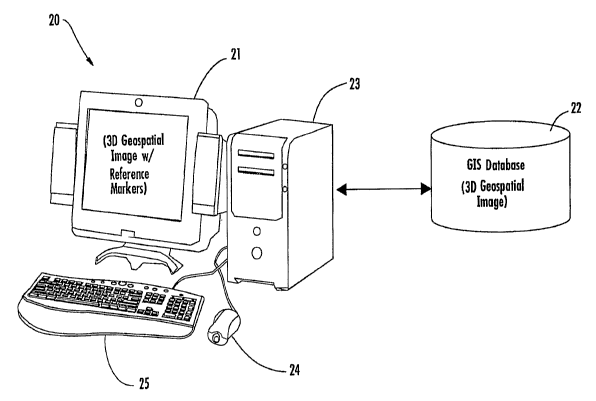
FIG. 1 is a schematic block diagram of an exemplary
geographic information system (GIS) in accordance with the
invention.
FIG. 2 is a sample display of a 3D image with
reference markers in accordance with the invention with
selectively displayed position data.
FIG. 3 is a sample display of the 3D image of FIG. 2
displaying a distance between a pair of reference markers and
with a different spacing between reference markers.
FIG. 4 is a sample display of the 3D image of FIG. 2
displaying a vertical reference line from the ground surface
in the image to a reference marker, and the associated height.
FIG. 5 is a sample display of the 3D image of FIG. 2
with an alternative embodiment of the reference markers having
-4-
CA 02651318 2008-11-04
WO 2007/130539 PCT/US2007/010774
different colors to indicate different relative positions
within the image.
FIG. 6 is a sample display of another 3D image
including semi-transparent spherical reference markers in
accordance with the invention.
FIG. 7 is a sample display illustrating a 3D
geospatial image display method in accordance with the
invention.
The present invention will now be described more
fully hereinafter with reference to the accompanying drawings,
in which preferred embodiments of the invention are shown.
This invention may, however, be embodied in many different
forms and should not be construed as limited to the
embodiments set forth herein. Rather, these embodiments are
provided so that this disclosure will be thorough and
complete, and will fully convey the scope of the invention to
those skilled in the art. Like numbers refer to like elements
throughout, and prime and multiple prime notation are used to
indicate similar elements in alternate embodiments.
Referring initially to FIG. 1, a geographic
information system (GIS) 20 illustratively includes a display
21, a GIS (or other 3D image) database 22, and a processor 23
(e.g., a computer CPU). Moreover, input devices such as a
mouse 24 and a keyboard 25 are connected to the processor 23
for allowing a user to interact with and manipulate data
(e.g., image data) displayed on the display 21. Other input
devices such as a joystick (not shown) may also be used, as
will be appreciated by those skilled in the art.
Generally speaking, the processor 23 cooperates with
the display 21 and the GIS database 22 to display a three-
dimensional (3D) geospatial image stored in the GIS database,
along with a plurality of spaced-apart reference markers 30a-
301 therein. In FIGS. 2-5, the 3D image is simply a ground
(e.g., terrain) surface or grid so that the reference markers
-5-
CA 02651318 2008-11-04
WO 2007/130539 PCT/US2007/010774
30a-301 are more easily identifiable. Moreover, the reference
markers 30a-301 are spheres in these embodiments, but other
geometric shapes or markers may also be used.
The reference markers 30a-301 advantageously have
different visual characteristics indicative of different
relative positions within the 3D geospatial image to help
users more readily distinguish the relative positions of
object vertices, boundaries, elevations, etc., within an
image. By way of example, in FIGS. 2-4 the different visual
characteristics of the reference markers 30a-301 are their
different relative sizes. For example, the reference marker
30a which is in the foreground is larger than the reference
marker 301 in the background, which indicates to the user that
the reference marker 30a is "closer" with respect to the
particular angle at which the user is viewing the 3D image
(i.e., closer from the user's vantage point).
Other visual characteristics besides size may be
used to help visually indicate to a user the relative position
of reference markers within an image. For example, in the
alternative embodiment illustrated in FIG. 5, reference
markers 30a'-30i' have different colors (illustrated by
different grayscale shade) to indicate their relative
positions within the image. In this example, the darker
colored reference markers appear in the foreground, and as the
markers get farther away from the user's vantage point their
color becomes lighter, although other arrangements may also be
used. In some embodiments, both color and size may be used to
indicate relative positions within an image, as will be
appreciated by those skilled in the art. Moreover, individual
reference markers may be colorized based upon elevation from
the ground surface 31 (in a geo-referenced context), or more
generally, based upon a distance from a pre-defined point or
surface.
-6-
CA 02651318 2008-11-04
WO 2007/130539 PCT/US2007/010774
The processor 23 may also advantageously associate
with each reference marker selectively displayable position
data. Thus, in the case of a 3D geospatial image of a
particular city or other location in which the points in the
S image are referenced to actual latitude, longitude, and/or
height/elevation coordinates for the particular city, etc.,
the processor 24 will associate respective position data with
each reference marker 30a-301 based upon its position within
the image, as will be appreciated by those skilled in the art.
Of course, for applications other than GIS (e.g.,
architectural design applications, digital design modeling
tools, etc.), the position data may be referenced to a
particular object in a scene based upon a scale, etc., as will
be appreciated by those skilled in the art.
In particular, the processor 23 may cause the
display 21 to display the position data associated with a
given reference marker 30 when the user selects the given
reference marker. In the example illustrated in FIG. 2, the
user has selected the reference marker 30a by moving a mouse
cursor 32 to point thereto, which causes the processor to
generate a pop-up window 33 displaying the latitude,
longitude, and height/elevation coordinates associated with
this particular reference marker. In other cases, selection
could be performed by pressing a given mouse button or
keyboard key, for example. Additionally, the given reference
marker's current coordinates may be displayed and updated in
real time as the density of the reference markers is changed,
if desired, as will be discussed further below.
The mouse 24 may also be used to draw a line 34
between a pair of reference markers 30a and 30g, as seen in
FIG. 3. This may done by simply selecting a first reference
marker (here the reference marker 30a), such as by clicking a
mouse button when the mouse pointer 32 is pointing thereto,
and then dragging the line 34 to the second reference marker
-7-
CA 02651318 2008-11-04
WO 2007/130539 PCT/US2007/010774
30g and releasing the mouse button. Of course, other
approaches for selecting and/or drawing lines between
reference markers may also be used, as will be appreciated by
those skilled in the art. The processor 23 may also display
the pop-up window 33, which in this example displays a
distance between the two reference markers (i.e., 2 m). This
feature may be particularly beneficial for city planners,
etc., who need to determine a distance from one point in a 3D
scene (such as the top of one building) to another point
(e.g., the top of another building), for example.
Yet another similar feature is that the mouse 24 (or
keyboard 25 or other appropriate input devices) may be used to
select a given reference marker 30a so that the processor 23
may cause a vertical reference line 35 to be drawn between the
ground surface and the given reference marker upon selection
thereof, as seen in FIG. 4. That is, the vertical reference
line 35 provides a helpful reference for the user to determine
where the ground surface 31 directly beneath the given
reference marker 30a is located. In addition, the pop-up
window may also be generated on the display 21 by the
processor 23 with an indication of the distance between the
ground surface 31 and the given reference marker 30a (here, 5
m).
The reference markers may be semi-transparent
geometric objects, such as semi-transparent spheres 30 ", for
example, as shown in FIG. 6. In particular, the spheres 30"
in the illustrated example delineate points on an object 40,
which could be a building (i.e., a manmade structure),
elevated terrain, etc. When a given reference marker
intersects the object 40, the processor 23 may advantageously
display only those portions of the given reference marker
outside of the object, as shown, to further help the user
appreciate the relative position and boundaries of the object
while not obscuring the object itself.
-8-
CA 02651318 2008-11-04
WO 2007/130539 PCT/US2007/010774
The processor 23 may also cause the display 21 to
selectively change the spacing between the reference markers
30a-301 based upon one of the input devices. For example, the
processor 23 may change the spacing (i.e., density) of the
reference markers 30a-301 based upon a scroll wheel of the
mouse 24, which may be done in combination with pressing a
particular key (e.g., CTRL key) on the keyboard 25. Thus, the
user is able to quickly and conveniently change the spacing of
the reference markers 30a-301 to suit the particular image or
zoom level that the user is working with. Of course, the
reference marker density may also be automatically updated as
the user changes zoom-level, if desired.
The processor 23 may also selectively display the
reference markers 30a-301 with the 3D geospatial image, i.e.,
only display them when requested by the user. For example,
this may be done based upon one of the input devices such as
the keyboard 25. More particularly, a specific key(s) on the
keyboard 25 may be assigned for causing the processor 23 to
display the reference markers 30a-301 when pressed or held
down by the user (e.g., the space bar), and then "hide" the
reference markers when the user releases the designated
key(s). Of course, other methods may be used for instructing
the processor 23 to display the reference markers 30a-301 (as
well as performing the various functions described above),
such as drop down menu items, buttons on a button bar, etc.,
as will be appreciated by those of skill in the art.
A three-dimensional (3D) geospatial image display
method aspect will now be described with reference to FIG. 7.
Beginning at Block 70, the method illustratively includes
displaying a 3D geospatial image on the display 21 with a
plurality of spaced-apart reference markers 30a-301, at Block
72. As noted above, the reference markers 30a-301 preferably
have different visual characteristics indicative of different
-9-
CA 02651318 2008-11-04
WO 2007/130539 PCT/US2007/010774
relative.positions within the 3D geospatial image (e.g., size,
color, etc.).
The method may further include associating with each
reference marker selectively displayable position data, at
Block 74, as discussed further above. The processor 23 then
cooperates with the mouse 24 and/or keyboard 25 to determine
when a given reference marker 30 is selected, at Block 76.
When this occurs, the processor 23 then performs the
appropriate action, such as displaying the respective position
data associated with the given reference marker 30, as noted
above, at Block 78, thus concluding the illustrated method
(Block 80).
The reference markers 30a-301 may be expanded to
span an entire viewable scene (i.e., view frustum), or just
portions thereof in different situations or'i.mplementations.
Moreover, the reference markers 30a-301 may also
advantageously be used to place pre-defined objects in the 3D
scene, or to define entirely new objects by successively
selecting markers, for example. Preferably the grid or matrix
of reference markers 30a-301 will have a regular spacing by
default. However, additional user or context-definable
parameters may be used to automatically increase the sphere
density in certain areas causing the dynamic increasing and
decreasing of the grid density to be non-uniform or even non-
linear throughout the extent of the grid, as will be
appreciated by those skilled in the art.
Operational details of one exemplary embodiment of
the computer system 20 will now be described to provide still
further understanding. The keyboard 25 spacebar brings in
(i.e., overlays) the matrix of reference markers 30a-301
(i.e., spheres), which are appropriately sized to match the
context, over the whole image scene or some portion thereof.
The keyboard 25 and/or joystick may be used to move the camera
view around in the scene. Further, a scroll wheel on the
-10-
CA 02651318 2008-11-04
WO 2007/130539 PCT/US2007/010774
mouse 24 dynamically increases/decreases the matrix density
(i.e., inter-sphere spacing). Optionally, the dynamic grid
density adjustment does not necessarily need to be uniform or
linear across entire matrix/grid, as noted above.
Each time the mouse pointer 32 mouse moves over a
selectable reference sphere, (a) if there is a ground surface
portion below the sphere, a straight vertical reference line
35 is automatically drawn to the ground 31 to show exactly
over what ground point that sphere lies, and (b) if the scene
is-within a GIS context (i.e., has an origin), the
latitude/longitude/height coordinates of the given sphere are
shown preferably even if no ground exists below. Optionally,
the spheres may be colorized based upon height/elevation or
distance from a certain point (showing appropriate color bar
legend on the side of the scene). In addition, clicking on a
given sphere may select it and optionally close out a polygon
(or volprint, as discussed in U.S. Patent No. 6,915,310 to
Gutierrez et al., which is assigned to the present Assignee
and is hereby incorporated herein by reference in its
entirety) if more than one sphere is selected. In a
degenerate polygon case, two selected spheres make a line, as
will be appreciated by those skilled in the art.
The above-described computer system 20 and methods
may provide several advantages. For example, they may provide
full 3D context relatively fast and with few operations
required by a user, as well as providing a GIS
(latitude/longitude/height) context for any 3D point in a
scene. Furthermore, radial colorization may be provided based
upon a distance from a point or object, or planar colorization
based upon a distance from surface (e.g., ground). Other
advantages may include dynamic density calibration, as well as
non-uniformity in dynamic density calibration (i.e., areas of
interest can be adjusted to have a higher density than the
rest of the matrix). Moreover, polygon orientation (i.e.,
-11-
CA 02651318 2008-11-04
WO 2007/130539 PCT/US2007/010774
winding, in computer graphic terms, which is used to determine
if a polygon is front-facing or back-facing) may optionally be
automatically deduced from the order that the user selects the
spheres.
-12-