Note: Descriptions are shown in the official language in which they were submitted.
CA 02651853 2008-11-07
WO 2007/133967
PCT/US2007/068248
ESTIMATION OF POSITION USING WLAN ACCESS POINT RADIO
= PROPAGATION CHARACTERISTICS IN A WLAN POSITIONING
SYSTEM
Background
Field of the Invention
[0001] The invention generally relates to positioning systems and, more
specifically, to methods and systems of estimating attributes of user movement
(e.g., position, speed, and direction) using WLAN access point radio
propagation
characteristics in a WLAN positioning system.
Discussion of Related Art
[0002] Position deteimination is the main component of navigation
systems
and any Location Based Services (LBS). Proliferation of WLAN access points in
recent years created a blanket of WLAN radio waves everywhere. Therefore,
almost in any place, there is a great possibility of detecting WLAN radio
waves,
especially in urban areas. The exponential growth of WLAN, and the fact that
they can be found almost everywhere, initiated an idea of leveraging them for
a
metropolitan positioning system for indoor and outdoor areas. In a
metropolitan
WLAN positioning system, location of WLAN access points are used as reference
points, and the Received Signal Strength (RSS) of a WLAN access point is used
as an indicator of a distance of an end user from the WLAN access points that
the
user detects at any time. By knowing the distance of the end user from WLAN
access points, location of the end user can be determined. Translating
receiver
Receive Signal Strength to distance relies on assuming a specific radio
channel
model. Ideally, if the radio channel model was exactly known, the exact
distance
of the end user to WLAN access points could be found.
[0003] Outdoor and indoor WLAN based positioning systems have been
explored by couple of research labs, but none of them included speed and
bearing
estimation in their system. The most important research efforts in this area
have
been conducted by PlaceLab (www.placelab.com, a project sponsored by
CA 02651853 2008-11-07
WO 2007/133967
PCT/US2007/068248
Microsoft and Intel), University of California San Diego ActiveCampus project
(ActiveCampus ¨ Sustaining Educational Communities through Mobile
Technology, technical report #CS2002-0714), and the MIT campus wide location
system, and it was evaluated through several small projects at Dartmouth
college
(e.g., M. Kim, J.J. Fielding, and D. Kotz, "Risks of using AP locations
discovered
through war driving").
[00041 There have been a number of commercial offerings of Wi-Fi
location
systems targeted at indoor positioning. (See, e.g., Kavitha Muthukrishnan,
Maria
Lijding, Paul Havinga, Towards Smart Surroundings: Enabling Techniques and
Technologies for Localization, Proceedings of the International Workshop on
Location and Context-Awareness (LoCA 2005) at Pervasive 2005, May 2005,
and Hazas, M., Scott, J., Krumm, J.: Location-Aware Computing Comes of Age.
IEEE Computer, 37(2):95-97, Feb 2004 005, Pa005, Pages 350-362.) These
systems are designed to address asset and people tracking within a controlled
environment like a corporate campus, a hospital facility or a shipping yard.
The
classic example is having a system that can monitor the exact location of the
crash
cart within the hospital so that when there is a cardiac arrest the hospital
staff
doesn't waste time locating the device. The accuracy requirements for these
use
cases are very demanding typically calling for 1-3 meter accuracy.
[00051 These systems use a variety of techniques to fine tune their
accuracy
including conducting detailed site surveys of every square foot of the campus
to
measure radio signal propagation. They also require a constant network
connection so that the access point and the client radio can exchange
synchronization information similar to how A-GPS works. While these systems
are becoming more reliable for indoor use cases, they are ineffective in any
wide-
area deployment. It is impossible to conduct the kind of detailed site survey
required across an entire city and there is no way to rely on a constant
communication channel with 802.11 access points across an entire metropolitan
area to the extent required by these systems. Most importantly outdoor radio
propagation is fundamentally different than indoor radio propagation rendering
these indoor positioning algorithms almost useless in a wide-area scenario.
The
required accuracy of indoor WLAN based positioning systems, makes it hard to
2
CA 02651853 2008-11-07
WO 2007/133967
PCT/US2007/068248
use radio channel modeling and it is considered as a research topic in that
domain.
In addition, none of the WLAN based positioning systems to date have
distinguished between access points, and current methods treat all WLAN access
points the same.
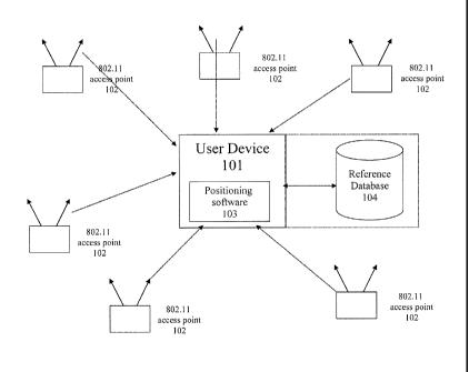
[0006] Figure 1 depicts a Wi-Fi positioning system (WPS). The
positioning
system includes positioning software [103] that resides on a computing device
[101]. Throughout a particular coverage area there are fixed wireless access
points [102] that broadcast information using control/common channel broadcast
signals. The client device monitors the broadcast signal or requests its
transmission via a probe request. Each access point contains a unique hardware
identifier known as a MAC address. The client positioning software receives
signal beacons from the 802.11 access points in range and calculates the
geographic location of the computing device using characteristics from the
signal
beacons. Those characteristics include the unique identifier of the 802.11
access
point, known as the MAC address, and the strengths of the signal reaching the
client device. The client software compares the observed 802.11 access points
with those in its reference database [104] of access points, which may or may
not
reside on the device as well. The reference database contains the calculated
geographic locations and power profile of all the access points the gathering
system has collected. The power profile may be generated from a collection of
readings that represent the power of the signal from various locations. Using
these known locations, the client software calculates the relative position of
the
user device [101] and determines its geographic coordinates in the form of
latitude and longitude readings. Those readings are then fed to location-based
applications such as friend finders, local search web sites, fleet management
systems and E911 services.
Summary
[0007] The invention provides methods and systems for estimating
position
using WLAN (e.g., Wi-Fi) access point radio propagation characteristics in a
WLAN location based service.
[0008] Aspects of the invention classifying WLAN access points based on
a
radio channel model can use any channel model, and the invention is
independent
3
CA 02651853 2008-11-07
WO 2007/133967
PCT/US2007/068248
of any specific channel model.
[0009] Under one aspect of the invention, a location-based services
system
has a plurality of Wi-Fi access points in a target area. The Wi-Fi access
points
are positioned at geographic locations and have signal coverage areas. A
method
of characterizing at least one of the Wi-Fi access points comprises
determining
the geographic location of the Wi-Fi access point, dividing the signal
coverage
area of the Wi-Fi access point into at least one section, and detei mining
radio
propagation characteristics for each section. The radio propagation
characteristics
of each section characterize a radio channel of the Wi-Fi access point, and
the
characterization can be used in a location algorithm.
[0010] Under another aspect of the invention, the signal coverage area
is
characterized as one section.
[0011] Under another aspect of the invention, the signal coverage is
divided
into more than one section. Under certain embodiments, radials emanating
outward from the Wi-Fi access point form the sections. Under further
embodiments, sections are formed based on a distance from the Wi-Fi access
point. Under yet further embodiments, sections are formed based on both
radials
and distances from the Wi-Fi access point.
[0012] Under another aspect of the invention, a plurality of received
signal
power values within the signal coverage area is measured. Each received signal
power value is measured at an associated position relative to the Wi-Fi access
point. The sections are determined based on the plurality of received signal
power values and associated positions.
[0013] Under another aspect of the invention, the radio propagation
characteristics include a signal power-distance gradient.
[0014] Under another aspect of the invention, the signal power-distance
gradient for each section is determined by measuring a plurality of received
signal
power values within the signal coverage area, each received signal power value
being measured at an associated position relative to the Wi-Fi access point,
performing a linear regression on the plurality of received signal power
values
and associated positions, and using a slope determined by the linear
regression to
calculate the signal power-distance gradient.
4
CA 02651853 2008-11-07
WO 2007/133967
PCT/US2007/068248
[0015] Under another aspect of the invention, the signal power-distance
gradient for each section is determined by measuring a plurality of received
signal
power values within the signal coverage area, each received signal power value
being measured at an associated position relative to the Wi-Fi access point. A
distance corresponding to each of the signal power values is calculated, the
distances being measured from the associated positions of the signal power
values
to the geographic loCations of the Wi-Fi access points. An average radius of
signal coverage is estimated using the standard deviation of the distances,
and the
average radius of signal coverage is used to calculate the signal power-
distance
gradient.
[0016] Under another aspect of the invention, the position of a Wi-Fi
enabled
device is estimated by the Wi-Fi enabled device communicating with Wi-Fi
access points within range of the Wi-Fi enabled device to cause the Wi-Fi
access
points to transmit signals. The Wi-Fi enabled device receives the signals
transmitted by the Wi-Fi access points and identifies the Wi-Fi access points.
Calculated locations and estimated radio propagation characteristics of the Wi-
Fi
access points are retrieved from a reference database using Wi-Fi access point
identifiers. The calculated locations and the estimated radio propagation
characteristics are used to estimate the position of the Wi-Fi enabled device.
Brief Description Of Drawings
[0017] In the drawings,
Figure 1 depicts certain embodiments of a Wi-Fi positioning system;
Figure 2 depicts a line fit to RSS samples, defining an example access
point coverage area according to certain embodiments of the invention;
Figure 3 depicts dividing a coverage area of an access point into sectors
according to certain embodiments of the invention;
Figure 4 depicts a coverage area of an access point characterized with
multiple power distance gradients according to certain embodiments of the
invention;
CA 02651853 2014-05-30
Figure 5 depicts a coverage area of an access point divided into multiple
sectors and tiers according to certain embodiments of the invention; and
Figure 6 depicts RSS sample statistics in a two dimensional surface
identifying the radius of the coverage area according to certain
embodiments of the invention.
Detailed Description
100181 Embodiments of the invention provide a methodology to classify
WLAN access points based on their radio propagation characteristics in a WLAN
based positioning system and to increase the accuracy of position, velocity
and
bearing estimations. Under certain embodiments, radio propagation
characteristics of WLAN access points are estimated based on RSS samples in
their coverage area. For example, radio propagation characteristics can be
characterized by finding one or more signal power-distance gradients for at
least
one of the WLAN access points.
[0019] There are different physical phenomena that impact Received Signal
Strength (RSS) variation in the dimensions of space and time. The RSS
variation
is categorized as either fast fading or slow fading. The techniques disclosed
herein focus on estimating the slow fading characteristics of the RSS and also
assess the estimation quality and quantify the estimation.
[0020] Embodiments of the present invention build on techniques, systems
and methods disclosed in earlier filed applications, including but not limited
to
U.S. Patent Application No. 11/261,848, entitled Location Beacon Database,U
U.S.
Patent Application No. 11/261, 898, entitled Server for Updating Location
Beacon Database, U.S. Patent Application No. 11/261,987, entitled Method and
System for Building a Location Beacon Database, and U.S. Patent Application
No. 11/261,988, entitled Location-Based Services that Choose Location
Algorithms Based on Number of Detected Access Points Within Range of User
Device, all filed on October 28, 2005.
Those applications taught specific ways
to gather high quality location data for Wi-Fi access points so that such data
may
6
CA 02651853 2008-11-07
WO 2007/133967
PCT/US2007/068248
be used in location based services to determine the geographic position of a
Wi-
Fi-enabled device utilizing such services and techniques of using said
location
data to estimate the position of a system user. The present techniques,
however,
are not limited to systems and methods disclosed in the incorporated patent
applications. Thus, while reference to such systems and applications may be
helpful, it is not believed necessary to understand the present embodiments or
inventions.
[0021] Figure 2 depicts an example of embodiments of the invention
characterizing radio propagation characteristics of WLAN access points by
estimating a signal power-distance gradient for a WLAN access point in a WLAN
based positioning system. The coverage area of a WLAN access point may be
used to find a signal power-distance gradient. The minimum RSS [204] is
limited
by sensitivity of the scanner. Whereas, the maximum RSS [203] may be assumed
the same for all of the WLAN access points because the maximum transmit
power is defined as part of the Wi-Fi standard. Therefore, the coverage area
of a
WLAN access point is directly a function of the signal power-distance gradient
of
the WLAN access point.
[0022] Figure 2 represents RSS samples [201] as points on a graph
plotting
RSS power (in dB) [205] versus distance of the RSS sample from the access
point
(in dB) [206]. A signal power-distance gradient a can be determined by fitting
a
line [202] to the RSS sample points [201], where the slope of the line is
equal to
the signal power-distance gradient. Because a WLAN based positioning system
according to embodiments of the invention use radio waves of public and
private
WLAN access points in order to continuously estimate position of a user,
aspects
of the invention increase the accuracy of location estimation by using
individual
radio propagation characteristics of each WLAN access point, rather than a
standard value.
[0023] Under other embodiments of the present invention, the coverage
area
of a WLAN access point is divided into sectors, and radio propagation
characteristics are determined for each sector, e.g., a signal power-distance
gradient is found for each sector. For example, in a metropolitan area, the
radio
propagation characteristics of an access point is not symmetric across its
coverage
7
CA 02651853 2008-11-07
WO 2007/133967
PCT/US2007/068248
area, i.e., the characteristics vary in different directions. Under
embodiments of
the invention, the 360 degree coverage area of the WLAN access point is
divided
into multiple sectors when coverage of the WLAN access point is not symmetric
in all of the directions. The sectors may be divided according to radials
emanating from the estimated location of the WLAN access point.
[0024] For simplicity, the sectors may be referenced from the same
axis, for
example, the north direction. Because the radio propagation characteristics of
the
WLAN access point needs to be found in each direction, there is a need to have
enough RSS samples in each sector. Based on the statistics of the number of
RSS
power samples and their distribution, a number of sectors can be determined.
Increasing the number of sectors increases the resolution of the radio
propagation
characteristics because averaging is occurred in a smaller sector. However,
this is
conditioned on having enough RSS samples to be able to estimate the radio
propagation characteristics, e.g., power distance gradient, in each sector
accurately.
[0025] Figure 3 depicts an example of a WLAN access point [302] with
its
coverage area divided into four sectors [301]. The number of sectors varies
from
one WLAN access point to another, and it is selected for each WLAN access
point separately based on the number of RSS samples and the RSS sample
distribution in the WLAN access point coverage area. For example, in a
metropolitan WLAN based positioning system, if the RSS samples for a given
WLAN access point are non-uniform, then a relatively low number of sectors
will
be used for that WLAN access point. If RSS samples from the coverage area of a
WLAN access point indicate different radio propagation characteristics, such
as
different signal power-distance gradients, in different directions, the
coverage
area of that WLAN access point is divided into multiple sectors.
[0026] For example, if a WLAN access point is facing an open area from
one
side and residential area from the other side, the coverage area can be
divided into
two sectors, and corresponding radio propagation characteristics may be
determined for each sector. In at least one embodiment, for the general case
of a
metropolitan positioning system, a useful maximum number of sectors is in the
range of four to six, because distinguishing between sectors for higher
numbers of
8
CA 02651853 2008-11-07
WO 2007/133967
PCT/US2007/068248
sectors may be of limited value. The minimum number of sectors can be as small
as one, which means, for example, that one signal power-distance gradient is
used
for the whole coverage area.
[0027] After selecting number of sectors, radio propagation
characteristics
need to be calculated for each sector. Note that if number of RSS samples in
one
sector is not enough to estimate radio propagation characteristics in that
sector,
the average of the characteristics of the adjacent sectors may be used.
[0028] Under one embodiment of the invention, the radio propagation
characteristics of a WLAN access point can be presented by a piecewise linear
estimation. This may be accomplished by dividing the coverage area of the
WLAN access point into multiple tiers and finding the radio propagation
characteristics for each tier. This method can be used to increase the
accuracy of
RSS power to distance translation, e.g., when a WLAN access point coverage
area consists of indoor and outdoor environments. Thus, this approach may be
used to capture indoor and outdoor radio propagation characteristics
differently
by estimating a signal power-distance gradient for each tier.
[0029] Figure 4 depicts an example of RSS samples for a WLAN access
point
in which the RSS samples can be presented clearly with two signal power-
distance gradient values, one for use in the vicinity of the access point and
the
other for use at greater distances. Figure 4 present RSS samples plotted as
RSS
power [405] versus distance [406] ftom the WLAN access point. The minimum
scanner sensitivity [404] and maximum RSS value [403] are also shown. The
coverage area of a WLAN access point is divided into multiple tiers when it is
necessary. For example, if it is known that the coverage area of a WLAN access
point is partly indoor and partly outdoor. Alternatively, the need to use the
multi-
tier approach to characterize coverage area of a WLAN access point may be
detected by observing the RSS samples. A sharp change in the average decay of
power values of the RSS samples, as illustrated by the differing slopes of a
first
cluster of RSS samples [401] and a second cluster of RSS samples [402], may
indicate an environment change. A useful number of tiers has been found to be
two.
[0030] Figure 5 depicts an embodiment dividing the coverage area into a
9
CA 02651853 2008-11-07
WO 2007/133967
PCT/US2007/068248
combination of sectors and tiers. In this case, the coverage area of a WLAN
access point [501] can be divided to multiple sectors [502], and each sector
can be
further divided into multiple tiers [503], thus forming multiple sections
[504].
The number of sectors and tiers, and the corresponding radio propagation
characteristics, are considered part of the attributes of each WLAN access
point
when it is stored in the reference database [104], and these attributes are
retrieved
by the end user and used to estimate the user location.
[0031] Under one embodiment of the invention, the radio propagation
characteristics of a WLAN access point may be estimated using the signal power-
distance gradient for each sector, which is found based on RSS samples in the
designated area. One possible approach to finding a signal power-distance
gradient is by fitting a line to RSS samples with power (in dB) as a function
of
distance (in dB), as was discussed above in connection with Figure 2. Due to
power variation in a metropolitan indoor and outdoor WLAN positioning system,
this method may have low accuracy for a typical number of RSS samples in a
typical metropolitan environment.
[0032] Under one aspect of the invention, a novel approach to finding a
signal
power-distance gradient is disclosed, wherein the average radius of the
coverage
area of a WLAN access point is calculated and used to estimate the signal
power-
distance gradient. The average radius of coverage area can be used as an
indictor
of the signal power-distance gradient because the signal power-distance
gradient
is the ratio of RSS power to distance from the WLAN access point. Referring
again to Figure 2, if the points corresponding to the minimum RSS [204] and
the
maximum RSS [203] are considered, the power difference between the minimum
and the maximum power points are the same for all the access points, because
the
minimum power is bounded by the sensitivity of the scanner and the maximum
power is the maximum access point transmit power. The sensitivity of the
scanners collecting the RSS samples is nearly identical in the systematic
scanning
scenario, and the maximum transmit power is limited by, e.g., the FCC, for
WLAN access points and can be assumed the same for all the access points.
Therefore, the radius of coverage area is directly dependent on the signal
power-
distance gradient value.
CA 02651853 2008-11-07
WO 2007/133967
PCT/US2007/068248
[0033] In other words, the sensitivity of the scanner receiver limits
the
minimum RSS [204] which can be detected by the scanner. Therefore, the signal
power-distance gradient value directly impacts the radius of coverage area of
the
WLAN access point. Because the receiver sensitivity is the same for all
scanning
devices taking RSS samples, the radius of coverage area of the WLAN access
point can be used as an indicator of the value of signal power-distance
gradient,
as was shown in Figure 2.
[0034] In order to find the radius of coverage area of the WLAN access
point
and avoid the impact of fast fading on the RSS power reading, and subsequently
on the coverage, the standard deviation of the radius of coverage area instead
of
absolute radius of coverage area is used. In other words, absolute value of
the
radius of coverage area depends on a limited number of readings at the edge of
the coverage, but standard deviation is calculated based on the total number
of
RSS samples and reduces the impact of power variation at the edge of the
coverage area, while at the same time indicating the size of the coverage
area.
[0035] Figure 6 depicts a coverage area of an access point [601] and
power
distribution [604] as a function of the latitude [602] and longitude [603] of
the
power readings. The standard deviation of RSS samples referenced to the
location of access point [601] is directly correlated to the average radius of
the
coverage.
[0036] When the coverage area is not divided into multiple sections,
and the
whole area is considered as one area, the standard deviation is calculated
based on
all of the RSS readings around the access point. If the total number of RSS
samples of the access point is denoted by Nand corresponding latitude and
longitude of RSS sample i are denoted by (lath long), the standard deviation,
cs.,
of the radius of coverage area is calculated as follows:
cy Vax2
In which
11
CA 02651853 2008-11-07
WO 2007/133967
PCT/US2007/068248
I(d xj)2
2 i=1
= N > 1
N-1
a x =0,N =1,
1(C 1 02
2 tr.-1
= N > 1
N-1
ay =0,N =1,
[0037] The variables dxi and dyi are the distances of power sample from
the
WLAN access point in the X and Y directions in Cartesian coordinates. The
standard deviation calculation can be simplified as follows:
= lot _L long
In which
1(lat ¨ at)2
1 N >1
a lot =
N-1
alai =0,1V =1,
E(longi ¨ ong)2
2 1 N >1
a long =
N ¨1
along = 0, N = 1,
100381 In this equation, (lat, long) is the calculated location of the
WLAN
access point. The average radius of coverage is calculated based on a
Cartesian
presentation of location. Calculation of the radius of coverage can also be
simplified by considering latitude and longitude without converting them to
Cartesian coordinates. If the coverage area is divided into multiple sectors,
the
standard deviation is calculated based on the distance of RSS samples from the
WLAN access point, which can be considered in one dimension. Therefore, the
standard deviation is calculated as follows:
i)2
__________________________ ,N>1
N-1
= 0,N =1,
12
CA 02651853 2008-11-07
WO 2007/133967
PCT/US2007/068248
[0039] In which d, is distance of power sample i from the WLAN access
point.
[0040] The standard deviation of a radius of the coverage area is
translated to
the signal power-distance gradient using following equation:
a = amin, if (cr > o-.)
a = an., if (u < min)
log(o-) ¨ log(o-min )
= a.õ+(amin a.õ)( _____________________________ ), otherwise.
log(a) ¨ log(o-õõ,, )
[0041] In which amin and a. are minimum and maximum values of the
signal power-distance gradient, and anijn and a.ax are the minimum and maximum
thresholds of the WLAN access point coverage. The values of a.. and a.ax are
dependent on the environment in which the WLAN devices are operating. One
example of useful values for the minimum and maximum signal power-distance
gradients for a metropolitan WLAN based positioning systems are as follows:
am,õ = 2,
aniax = 6.
In this case, the maximum value of a is the typical maximum value for an urban
area.
[0042] The minimum and the maximum values of the standard deviation are
found based on typical minimum and maximum radii of coverage of WLAN
access points, which may be found empirically. Useful minimum and maximum
radii of coverage of WLAN APs are 60 and 700 meters, respectively. If the
coverage is considered as five-sigmia value, the minimum and maximum sigma
value can be calculated.
[0043] In the case of multi tier approach, after finding the boundary
of each
tier, the signal power-distance gradient for each tier may be found by fitting
a line
to RSS samples within each tier using the method discussed in connection with
Figure 2 above. The standard deviation approach cannot be used, because the
minimum and maximum power values are not known for each tier, as it was
known for the whole coverage area. Figure 4 depicts an example of a multi-tier
access point and illustrates the exact transition point from the first cluster
of RSS
13
CA 02651853 2008-11-07
WO 2007/133967
PCT/US2007/068248
samples [401] and the second cluster of RSS samples is not known, as some of
the RSS samples considered to belong to the first cluster [401] may actually
belong to the second cluster [402]. Estimating this transition point
introduces
error using the standard deviation approach.
[0044] According to embodiments of the invention, signal power-distance
gradient(s) for each WLAN access point may be used by the user to find its
distance to each WLAN access point in range and consequently locate itself.
Signal power-distance gradient can be used in the following equation to find
the
distance:
d=al _____________
"RSS
[0045] The notation Pos is the received power from a WLAN access point
in
watts and K is a constant number aggregating all other parameters. The value
of d
can be normalized to K by assuming K equal to one without sacrificing
accuracy.
Assuming K equal to one is the same as changing the scale of the distance
measurement, and because it can be made the same for all access points,
normalizing K does not impact the accuracy of position estimation.
100461 Under aspects of the invention, the location of access point,
(lat ,Iong),
may be calculated. If the exact location of an access point is not known, the
RSS
samples and their corresponding locations can be used to estimate the location
of
the access point. For example, location of the access point can be found by
finding the center of power readings as follows:
lat = _________ 1=1
Ilong;
long = ________________
Wherein the total number of power samples is equal to N.
[0047] Charactering the unique radio propagation characteristics of
each
WLAN access point in a location system, instead of using one set of
characteristics for all the WLAN access points, increases the accuracy of
position,
14
CA 02651853 2008-11-07
WO 2007/133967
PCT/US2007/068248
speed of travel, and direction of travel estimations in a WLAN based
positioning
system. One example of a positioning algorithm is show below, which
illustrates
the use of signal power-distance gradients estimated according to embodiments
of
the invention. This example is a triangulation algorithm weighted according to
the distance of the user from the access points.
[0048] If a user detects N number of access points with a corresponding
RSS
value of Pi, a signal power-distance gradient of ai, a latitude of lati, and a
longitude of longi, the distance of the user to the access points is
calculated as
follows:
1
\I
P,
[0049] Latitude and longitude of the user, U/a, and thong, can be found
as
follows:
U= __________________
int N 1
IT
long,
= _______________ '
4; d
'
"long N 1
,=I NI
[0050] Under another aspect of the invention, the RSS value reading by
the
end user can be notmalized, and the RSS power reading can be used to select
the
correct value of radio propagation characteristics, e.g., a signal power-
distance
gradient, in the case of multi tier approach. When a coverage area is divided
into
multiple tiers with piecewise linear estimation of the coverage area, the user
must
be able to determine in which tier he is located, and use the radio
propagation
characteristics. In this case, there is a need to normalize the RSS power
reading
across different hardware and different Wi-Fi receiver implementations. In
order
to notinalize the RSS power reading, the minimum and the maximum power
sensitivity of the user's device are mapped to the dynamic power range of the
scanner used to supply data to the reference database [104].
CA 02651853 2008-11-07
WO 2007/133967
PCT/US2007/068248
[0051] If the scanners used to supply data to the reference database do
not
have a standard dynamic power range, the same normalization method may be
used to map the individual dynamic ranges of the different scanning devices to
a
standard dynamic range. Thus, this method can be used in a WLAN positioning
system when the hardware differs between scanners. In this case, a standard
dynamic range for the power is selected by selecting a minimum and a maximum
value for power reading, and all readings from all the different devices are
mapped to this range.
[0052] For example, if the standard minimum power and the maximum power
values are set to -100 dBm and -40 dBm, respectively, and a user device's
minimum and maximum range is between ¨90 dBm and ¨60 dBm, the power
readings of the user is nofinalized as follows:
Pnew =[Pold ¨ + (-100)
[0053] It will be appreciated that the scope of the present invention is
not
limited to the above-described embodiments, but rather is defined by the
appended claims, and these claims will encompass modifications of and
improvements to what has been described.
[0054] What is claimed is:
16