Note: Descriptions are shown in the official language in which they were submitted.
CA 02653908 2008-12-24
WO 2008/000093 PCT/CA2007/001173
METHOD AND SYSTEM FOR DISPLAYING AND COMMUNICATING
COMPLEX GRAPHICS FILE INFORMATION
Cross Reference To Related Application
[0001] The present application claims the benefits, under 35 U.S.C. 119(e), of
U.S. Provisional Application Serial No. 60/817,072 filed June 29, 2006
entitled "Method and System for Displaying and Communicating Complex
Graphics File Information" which is incorporated herein by this reference
Technical Field
[0002] The invention relates to the conversion, communication and display of
electronic graphics documents and in particular to transforming, conversion,
communication and display of computer graphics files.
Back rgound
[0003] Various computer software products are available for creating computer
graphics files, such as computer-aided design or CAD files. Popular
examples are AutoCADTM, Visio, Intellicad, Imagineer, Microstation and
others. Files created by such programs contain complex CAD file layer
information which requires the user to have a copy of the application
software program to adequately view the file. Such software programs are
typically expensive, complex and take considerable time to learn to use.
However it is often desirable for a person who has created a CAD file to be
able to send the file electronically, such as over the Internet, such that a
recipient can display and manipulate the document. Currently, however the
recipient will require his or her own copy of the CAD application software
and be familiar with its use in order to do so. Consequently there is a need
for a method to convert CAD files to a portable format which can be
received and displayed using readily available software on any platform.
[0004] It is known to distribute and display maps electronically over the
Internet by
the map server dividing the map into sections or tiles and when a client
requests an image of a location the server determines which map tile or tiles
cover that location and delivers same to the client. See U.S. patent no.
6724382 Kenyon et al. and Google Inc. U.S. published patent application
CA 02653908 2008-12-24
WO 2008/000093 PCT/CA2007/001173
-2-
no. 2005/0270299 entitled "Generating and Serving Tiles in a Digital
Mapping System".
[0005] The foregoing examples of the related art and limitations related
thereto are
intended to be illustrative and not exclusive. Other limitations of the
related
art will become apparent to those of skill in the art upon a reading of the
specification and a study of the drawings.
Summary
[0006] The following embodiments and aspects thereof are described and
illustrated
in conjunction with systems, tools and methods which are meant to be
exemplary and illustrative, not limiting in scope. In various embodiments,
one or more of the above-described problems have been reduced or elimi-
nated, while other embodiments are directed to other improvements.
[0007] The invention discloses a system and method of communicating and
display-
ing complex graphics files, comprising: a) the user selecting a graphic file
to
be communicated; b) rendering each layer of the graphic file to thereby form
a layer raster file containing raster information for each layer and draw
order information; c) converting the layer raster file to a file format which
is
readable by the client's browser software; and d) the client accessing a web
site using internet client side browser software and requesting the converted
file. According to one aspect of the invention, the graphic file is rendered
by rendering each layer of said graphic file while storing the drawing order
information for the data in each layer, and then sorting the data for all
layers
by drawing order values.
[0008] The layer raster file may comprise a field for each pixel identifying
the
transparency value, object identification or elevation associated with the
pixel. These fields permit te method to be used in combination with map
display applications to display graphics or object identification information
superimposed on the maps. While the invention is described as applied to
CAD files it also is useful in communicating and displaying other types of
files such as GIS.
CA 02653908 2008-12-24
WO 2008/000093 PCT/CA2007/001173
-3-
[0009] In addition to the exemplary aspects and embodiments described above,
further aspects and embodiments will become apparent by reference to the
drawings and by study of the following detailed descriptions.
Brief Description of Drawings
[00010] Exemplary embodiments are illustrated in referenced figures of the
draw-
ings. It is intended that the embodiments and figures disclosed herein are to
be considered illustrative rather than restrictive.
[00011] Fig. 1-3 are schematic drawings illustrating the problem addressed by
the
invention.
[00012] Fig. 4 is a schematic diagram illustrating a system according to the
inven-
tion.
[00013] Fig. 5 is a flowchart illustrating the overall method of the
invention.
[00014] Fig. 6 is a flowchart illustrating the method of making a file
according to the
invention.
[00015] Fig. 7 is an illustration of different tools that can be provided for
the client.
[00016] Fig. 8 through 19 illustrate different displays of a CAD diagram to a
client.
[00017] Fig. 20 through 22 illustrate schematically an additional feature of
the
invention.
[00018] Fig. 23 is a screen display illustrating the display of a CAD diagram
to a
client in combination with a map search application.
Description
[00019] Throughout the following description specific details are set forth in
order to
provide a more thorough understanding to persons skilled in the art.
However, well known elements may not have been shown or described in
detail to avoid unnecessarily obscuring the disclosure. Accordingly, the
CA 02653908 2008-12-24
WO 2008/000093 PCT/CA2007/001173
-4-
description and drawings are to be regarded in an illustrative, rather than a
restrictive, sense.
[00020] With reference to Fig. 4, a user 12 has a server accessible to the
Internet 20,
which has in memory CAD application software, such as AutoCAD, and
one or more CAD files, such as dwg files, which it wishes to send to
clients 10 over the Internet 20 for viewing, markup and annotation. Clients
have standard browser software such as Internet Explorer or Firefox to
access the World Wide Web but may or may not have their own CAD
10 application software. The client 10 uses its browser software to view, mark
up, annotate, pan and zoom the CAD file with full layer controls and does
not need an installer, ActiveX controls or Java applets to do so.
[00021] An application service provider or host 14 has a web site accessible
to user
12 and client 10 over the Internet and has the software to carry out the
invention. The system permits user 12 to upload a.dwg file to the service
provider 14, which is converted as described below, and then email the
URL for the diagram to clients 10 who can then access the web site of
service provider 14 and request and be served files in a format which can be
displayed by standard browser software, such as png files, jpeg, gif or
.tiff. The client can also mark or annotate the files, which annotations can
be saved and viewed by user 12 and clients 10.
[00022] The present process, which allows a user 12 to communicate and allow a
client 10 to display, mark and annotate complex graphics files may also be
carried out with the application program installed on the user's server rather
than the application program being hosted on the service provider 14 server
which is accessed both by the user 12 and its client 10.
[00023] The present process involves encapsulating CAD file layer information
data
into a custom file format that can be used to generate raster images "on the
fly" to the client. This process allows a user to display raster maps in an
efficient manner to the client while preserving the accuracy of the complex
CAD file layer information. In addition the format will allow for "on the
fly" raster transformation, that may include, but are not limited to: flip,
rotate, original geometry xrefs. This following illustrates the process used
CA 02653908 2008-12-24
WO 2008/000093 PCT/CA2007/001173
-5-
to create the custom files, the file format and optimizations, and finally the
process used to serve the file to the client 10.
Layer Raster File Creation
[00024] The process generally involves three stages:
[00025] 1) Data Acquisition stage: During this stage the user 12 selects which
files and rendering options it wishes to commit to the application
program which is operated by the service provider (referred to as
"the Tiler") and uploads the CAD file.
[00026] 2) Data Preparation stage: During this stage the CAD file that has
been
uploaded to the service provider is rendered at different zoom levels
in order to produce a "raster image grid" or "Tile Network". This
network of tiles is what the client 10 will see as final images.
[00027] 3) Data Presentation stage: In this stage a custom server control
inter-
faces with the client side browser, using AJAX technology. This
allows for the presentation and calculation of events based on user
actions.
[00028] Looking first at the Data Acquisition stage, the user 12 accesses the
system
by accessing the host's 14 web site and is served up a page to select the
rendering options to be applied to the file which will be processed, such as
the initial height and width of the image, the zoom factor (the percentage
change of relative size of the image with each zoom step) and the number of
times the zoom can be activated in one direction. Other features may also
be selected, such as whether the image will have a border, whether anti-
aliasing will apply, and the like. The user 12 then selects the CAD file to
be processed, such as by browsing and hitting a "submit" button, thereby
uploading the dwg or other file to the service provider 14 to be converted
to the necessary format as described below.
[00029] Looking next at the Data Preparation stage, typically CAD or GIS files
have
various layers as well as a draw order associated with different elements.
One of the goals of the present invention is to provide the client 10 with a
CA 02653908 2008-12-24
WO 2008/000093 PCT/CA2007/001173
-6-
tool set to manipulate the displayed image which includes "Layer" function-
ality. Layer functionality is the ability to make entities that are common to
a
layer visible or hidden. The problem with raster images such as PNG files,
is that there is no such layer support. To make the problem more complex,
entities in CAD layers do not have to be the same draw order. That is to
say that a layer is not like a transparent film with entities painted onto
that
film. Instead a layer should be viewed as a grouping of entities entirely
unrelated to a concept of "layer" or "transparent film". To better illustrate
the example see Fig. 1. Fig. 1 illustrates a circle 10, triangle 12 and square
14, which were created in left to right order. Circle 10, triangle 12 and
square 14 had their layers set as layers 1, 2 and 1 respectively. Fig. 2
illustrates the arrangement by the CAD program of the foregoing entities
into a single scene such that they all overlap. Although the circle and
square are of the same layer, they are overlapped by the triangle.
[00030] The data that is captured from the scene needs to be in association
with the
layers that they are on. The tile render must render once for each layer to
capture the layering information. Fig. 3 shows an example of rendering
first layer 1, then layer 2.
[00031] Now that one has the information is associated with layers, one still
cannot
simply overlay the data. Overlaying the data would cause the layers to
compete for which data was in view. In addition, data that was occluded by
information above it may be missed. In addition to this, if one created new
elements for the portion of entities that overlap, one would be increasing the
amount of data by a factorial function based on the number of layers and all
possible combinations of overlap.
[00032] The foregoing problem is solved by rendering the layer while storing
the
drawing order information. This information is accumulated for each layer
into a "Layer Raster container" structure. Once all layer data has been
added to the structure, the information is sorted by the drawing order. One
example of a way to gather the data is layer by layer, described as follows.
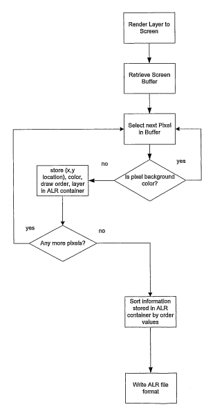
The algorithm can be summed up as follows:
for each Layer do:
Render Layer to Screen;
CA 02653908 2008-12-24
WO 2008/000093 PCT/CA2007/001173
-7-
Retrieve Screen Buffer;
for each Pixel in Buffer do:
If pixel is not background color:
store (x,y location), color, draw order, layer
in ALR container
end for;
end for;
Sort information stored in ALR container by order values;
Write ALR file format;
[00033] Other information could at this time also be included in the Layer
Raster file ,
information such as an XREF into original geometry set, contained in an
associated Annotation layer XML file, as described below.
ALR File Format
[00034] The format to which the Layer Raster file is stored on disk is
described as
follows. The Layer Raster file (referred to as the "ALR file") is stored on
disk in
a format that attempts to be optimal for both size and efficiency of
information
retrieval. Since the encoding of data from RGB to PNG format on the fly is a
factor larger then "N" where "N" is the size of bytes in the original RGB
file, it
is sufficient to have the information retrieval process take "N" or less steps
without increasing the overall runtime, that is, the minimum time it would
take
to scan through "N" items is "N". One needs to determine information about
these "N" items that are scattered through the ALR file and possibly on "M"
layers. The question now becomes the complexity of asking "M" questions
about "N" items.
[00035] Pixel data from the original Screen buffer is encoded into a "Packet"
of infor-
mation. The information that is required is: the x and y location of the color
data in the new raster, the layer that the pixel belongs to and the color of
that
pixel. This data is encoded in one way as follows (there could be any number
of
bits) as follows.
CA 02653908 2008-12-24
WO 2008/000093 PCT/CA2007/001173
-8-
X Y layer color
16 bits 16 bits 32 bits 32 bits
[00036] This storage allows for X to range from 0-65536 and Y to range from 0-
65536
as well as full support for RGBA 32bit color. This initial format has been
optimized based on the knowledge that these packets tend to order themselves
in medium to large sequences of packets of the same layer. So the format
changed with an initial packet to indicate the layer and the number indicating
the number of packet data following, that is of the same layer. This has the
result of reducing the file size by 1/3.
layer #in layer X Y color X Y color etc....
39 126 85 12 1589 86 12 1589 ...
[00037] The 32 bit layer value has also taken on a special meaning in order to
do fast
calculations based on its value. In CAD documents it is not uncommon to have
more than 200 layers. Which layers are on or off is determined by doing a
bitwise masking compare. (The mask is shown as value 0 for layers "off' but it
could also be value 0 for layers "on").
layer # 1 2 3
mask 0 1 0
pixel layer 0 0 1
Result 0 0 0
[00038] In the example above the mask indicates that only layer 2 is on. This
informa-
tion is compared with a pixel that is on layer 3 however. The result is that
no
pixel information will be drawn. This bitwise compare works well but there are
only have 32 bits for the layer info. This means that only 32 layers can be
represented. To get around this, the first 16 bits are used to represent a
plane or
dimension for the next 16 bits to be a mask on. The result is that one can now
have 65536 x 16 layers. So, for example, if a pixel is on layer 44 it would be
encoded in the following manner.
CA 02653908 2008-12-24
WO 2008/000093 PCT/CA2007/001173
-9-
Integer(44 / 16) = 2
So one knows that one is on the second plane.
44-(2* 16) = 12
So the information is encoded in the following way
16 bits 16 bits
2 12 bit on
0000000000000010 0001000000000000
[00039] This allows on the decoding phase to decode layering information with
an array
lookup for "dimension" and then a bitwise mask test on the resulting 16 bits.
The final format of the file including header information is included below
for
clarity. Since the layer information has been accumulated with a draw order to
sort on, the final format is already in order.
Size Purpose Example
4 bytes File Identifier 'ACLR'
4 bytes # Layers 45
4 bytes Background Color 0
4 bytes Image Width 250
4 bytes Image Height 250
4 bytes Layer Dimensions 16
4 bytes # of Packets 652349
2 bytes X location 35
2 bytes Y location 201
4 bytes Color 1458
4 bytes Layer 1
4 bytes # preceding pixels on layer 584
2 bytes X location 36
2 bytes Y location 201
4 bytes Color 1458
2 bytes X location 37
2 bytes Y location 201
File Serving
[00040] Since the client 10 does not recognize this ALR file format, it must
be con-
verted into a universally accepted format that can be digested by the client's
browser. The preferred format to serve to the client is PNG (portable network
graphic), but other formats such as JPEG or GIF formats are also suitable.
Clients make requests for ALR files that includes the information about which
layers are turned off. This information is encoded in a GET request, to take
advantage of proxy and gateway caching functionality. An example request
CA 02653908 2008-12-24
WO 2008/000093 PCT/CA2007/001173
-10-
from the client with layers 17, 24 and 35 turned off would look like the
following (where the host's URL is www.aftercad.com).
http://www.aftercad.com/xOylz3.alr?a--17-24-35
[00041] This request will come into the server where a custom request handler
for files
of alr extension has been registered. The request above would evoke the
custom handler. The handler would then be able to decode the GET request
into layers masks that represented the 'off layers. The requested ALR file is
read into memory and the pixels are processed according to the layer informa-
tion that was provided. Once processing of the ALR file is complete, the
caching headers and Mime types are set and the newly encoded PNG file
streamed back to the client. The result is a PNG raster image with the layers
the client requested to be turned off not present in the image.
[00042] To reduce processing time, only the tile portions of the drawing which
are
viewable by the client are served up, in a manner as utilized in other
existing
tiling applications.
[00043] With respect to the data presentation stage, Fig. 7 - 19 are
illustrations show-
ing how the CAD diagram can be served up to the client 10 after the client 10
has received the URL for the diagram from the user 12 and accesses the web
site with its browser. Fig. 7 illustrates different tools that can be provided
for
the client. Once the ALR file has been created by the host server and given a
file name, the user 12 can request to be served up the file from the host web
site, with accompanying tools, as shown in Fig. 7. The annotation and draw
tools utilize an Annotation XML file which is associated with the ALR file
and will be described in further detail below. The user 12 can then copy the
file's URL, or be prompted to have it copied for it, and forward the URL by
email to the client 10. Either the client 10 or the user 12 can use a browser
to
display and annotate the diagram.
[00044] Fig. 8 shows the CAD diagram as served up to the client 10, displaying
toolbar 80 and showing all layers. By clicking on the zoom tool the client can
successively zoom the diagram image as shown through Fig. 9, 10 and 11. In
Fig. 12 and 13 the client clicks on the layers tool, which displays thumbnail
images of each isolated layer along with buttons at 84 by clicking on which
CA 02653908 2008-12-24
WO 2008/000093 PCT/CA2007/001173
-11-
the layer can be removed.. In Fig. 14 and 15 a number of layers are succes-
sively removed from the full size diagram. Fig. 17 illustrates the tool bar
for
the draw tools and Fig. 18 illustrates the tool bar for the annotation tools.
The
client can place an annotation marker 82 on a point or an elliptical or rectan-
gular area as shown in Fig. 16 and clicking on the marker brings up a box in
which the client can type and edit text, shown in Fig. 19.
Annotation layer XML File Description
[00045] The Annotation layer XML File serves the following purposes:
1. To hold non-geometric metadata pertaining to a CAD file. Such
metadata includes, but is not limited to: a. general file metadata (title,
author, keywords, etc); b. layer metadata.
2. To hold CAD rendered image metadata. This refers to rendered
images that exist as thumbnail images, and ALR tiled image, and other
future rendered images. Metadata includes, but is not limited to: a.
Rendered images dimensions; b. Number of zoom levels of rendered
images.
3. To hold geometric data originally extracted from the CAD file and
geometry in addition to that originally extracted from the CAD file.
Such data includes, but is not limited to: a. Geometry type (lines,
rectangles, ellipses); b. Geometry coordinates.
4. To hold annotation data as created by the application. Such data
includes, but is not limited to: a. Annotation type (point, rectangle,
ellipse); b. Textual content.
5. The system can set and define various levels of access for adding,
editing, deleting annotations.
6. Tools such as a symbols library can be used to facilitate the making of
annotations, such as by dragging a symbol from the symbols library.
The Annotation layer XML File Format
[00046] Each CAD file rendered and uploaded to the server will have an
Annotation
layer XML File file associated with it. This file will contain the following
data:
CA 02653908 2008-12-24
WO 2008/000093 PCT/CA2007/001173
-12-
A) CAD File Metadata; This includes:
* objectDbHandle - to access through DWGDirect DB layer
* sourceFile (this metadata is embedded within AutoCAD file), such as: :
-- tileName - original source file name
-- title
-- subject
-- author
-- keywords
-- comments
-- hyperlink base
-- createdDate
-- lastModifiedDate
-- file size (bytes)
-- units - CAD units used (m, ft, km, mm, etc)
-- custom fields (v2)
B) Rendered Image Metadata, such as:
* width & height in pixels
* tile width & height
* number of zoom levels
* zoom factor
* units-per-pixel
* CAD origin in pixels
C) Layer Metadata, such as :
* layerDbHandle - to access through DWGDirect DB layer
* name
* visibility - On, Off, Frozen
D) Annotation Data, such as:
* annotation type
--rectangle annotation:
* top-left x,y & width/height in CAD coords
-- oval annotation:
CA 02653908 2008-12-24
WO 2008/000093 PCT/CA2007/001173
-13-
* centre x,y & width/height in CAD coords
-- point annotation:
* x,y in CAD coords
* annotation text
E) AfterCAD Geometry Data, such as
* geom id
* geom type (line, rect, ellipse):
-- line geom:
* xl,yl,x2,y2 in CAD coords
* strokecolor
-- rect geom:
* top-left x,y & width/height in CAD coords
* strokecolor
* isfilled/fillcolor
-- ellipse geom:
* top-left x,y & width/height in CAD coords
* strokecolor
* isfilled/fillcolor
[00047] The following is an example of an Annotation layer XML File:
<?xml version=" 1.0" encoding="utf-8"?>
<CADXML>
<Header ModificationDate="Thu May 18 00:23:04 2006" CreationDate="Sat Mar 08
11:58:19 2003"
Units="unitless" HyperLinkBase="""" DWGVersion="AC 1018" File-
Name="SAN.dwg"/>
<SmartLayerSummary AccessTime="Wed May 31 16:30:17 2006" Author="" Com-
ments=""
CreationTime="Tue May 23 23:24:11 2006" FileSize="2246584" HyperLinkBase=-
Keywords=""
LastSavedBy="" ModificationTime="Wed May 17 23:23:04 2006"
RevisionNumber="" Subject=""
Title=""/>
CA 02653908 2008-12-24
WO 2008/000093 PCT/CA2007/001173
- 14-
<LayerTable>
<LayerTableRecord Name="O" IsOn="true" IsFrozen="false" IsLocked="false"/>
<LayerTableRecord Name="FeatureAttribs" IsOn="false" IsFrozen="false"
IsLocked="false"/>
<LayerTableRecord Name="Unknown Area Type" IsOn="false" IsFrozen="false"
IsLocked="false"/>
<LayerTableRecord Name="STATE_PARK_RECREATION_AREA ARBO"
IsOn="false" IsFrozen="false" IsLocked="false"/>
<LayerTableRecord Name="MILITARY RESERVATION" IsOn="true"
IsFrozen="false" IsLocked="false"/>
<LayerTableRecord Name="NATIONAL PARK MONUMENT_LAKESHOR"
IsOn="false" IsFrozen="false" IsLocked="false"/>
<LayerTableRecord Name="SMALL PARK" IsOn="true" IsFrozen="false"
IsLocked="false"/>
<LayerTableRecord Name="Unclassified_Line_Feature" IsOn="false"
IsFrozen="false" IsLocked="false"/>
<LayerTableRecord Name="STATE_WILDLIFE_REFUGE_GAME_PRES"
IsOn="false" IsFrozen="false" IsLocked="false"/>
<LayerTableRecord Name="LARGE PARK" IsOn="true" IsFrozen="false"
IsLocked="false"/>
<LayerTableRecord Name="LAND GRANT" IsOn="false" IsFrozen="false"
IsLocked="false"/>
<LayerTableRecord Name="APPROXIMATE BOUNDARY" IsOn="false"
IsFrozen="false" IsLocked="false"/>
<LayerTableRecord Name="MONUMENTED POINT ON A BOUNDARY"
IsOn="false" IsFrozen="false" IsLocked="false"/>
<LayerTableRecord Name="BAYS_ESTUARIES_GULFS_OCEANSSEA"
IsOn="true" IsFrozen="false" IsLocked="false"/>
<LayerTableRecord Name="LAKE OR POND" IsOn="true" IsFrozen="false"
IsLocked="false"/>
<LayerTableRecord Name="OBSTRUCTION AREA IN WATER AREA"
IsOn="false" IsFrozen="false" IsLocked="false"/>
<LayerTableRecord Name="FLATS TIDAL MUD SAND GRAVEL " IsOn="tru-
e" IsFrozen="false" IsLocked="false"/>
<LayerTableRecord Name="RESERVOIR" IsOn="false" IsFrozen="false"
IsLocked="false"/>
CA 02653908 2008-12-24
WO 2008/000093 PCT/CA2007/001173
- 15-
<LayerTableRecord Name="RESERVOIR_COVERED" IsOn="false"
IsFrozen="false" IsLocked="false"/>
<LayerTableRecord Name=" SHORELINE" IsOn="false" IsFrozen="false"
IsLocked="false"/>
<LayerTableRecord Name="MANMADE_SHORELINE" IsOn="true"
IsFrozen="false" IsLocked="false"/>
<LayerTableRecord Name="CLOSURE LINE" IsOn="false" IsFrozen="false"
IsLocked="false"/>
<LayerTableRecord Name="PROCESSING LINE" IsOn="false" IsFrozen="false"
IsLocked="false"/>
<LayerTableRecord Name="Intermittent_Stream_or_River" IsOn="true"
IsFrozen="false" IsLocked="false"/>
<LayerTableRecord Name="STREAM" IsOn="true" IsFrozen="false"
IsLocked="false"/>
<LayerTableRecord Name="ROCK" IsOn="false" IsFrozen="false"
IsLocked="false"/>
<LayerTableRecord Name="UPPER ORIGIN_OF_STREAM" IsOn="false"
IsFrozen="false" IsLocked="false"/>
<LayerTableRecord Name="STREAM ENTERING_WATER_BODY" IsOn="false"
IsFrozen="false" IsLocked="false"/>
<LayerTableRecord Name="UPPER_ORIGIN_OF_STREAM AT_WATER"
IsOn="false" IsFrozen="false" IsLocked="false"/>
<LayerTableRecord Name="CHANNEL_IN_WATER AREA" IsOn="false"
IsFrozen="false" IsLocked="false"/>
<LayerTableRecord Name="APPARENT LIMIT" IsOn="false" IsFrozen="false"
IsLocked="false"/>
<LayerTableRecord Name="Unknown Point Feature" IsOn="false" IsFrozen="false"
IsLocked="false"/>
<LayerTableRecord Name="INTERMEDIATE_CONTOUR" IsOn="false"
IsFrozen="false" IsLocked="false"/>
<LayerTableRecord Name="INDEX CONTOUR" IsOn="false" IsFrozen="false"
IsLocked="false"/>
<LayerTableRecord Name="CARRYING CONTOUR" IsOn="false" IsFrozen="fals-
e" IsLocked="false"/>
<LayerTableRecord Name="SPOT ELEVATION LESS THAN 3RD OR"
IsOn="false" IsFrozen="false" IsLocked="false"/>
CA 02653908 2008-12-24
WO 2008/000093 PCT/CA2007/001173
-16-
<LayerTableRecord Name="UNSURVEYED AREA" IsOn="false" IsFrozen="false"
IsLocked="false"/>
<LayerTableRecord Name="ARBITRARY CLOSURE LINE" IsOn="false"
IsFrozen="false" IsLocked="false"/>
<LayerTableRecord Name="POINT_ON_SECTION_LINE NO_CORNER"
IsOn="false" IsFrozen="false" IsLocked="false"/>
<LayerTableRecord Name="HELIPORT PERIMETER OF HELIPORT"
IsOn="false" IsFrozen="false" IsLocked="false"/>
<LayerTableRecord Name="POWER TRANSMISSION LINE" IsOn="false"
IsFrozen="false" IsLocked="false"/>
<LayerTableRecord Name="ROAD_OR STREET_CLASS_3" IsOn="true"
IsFrozen="false" IsLocked="false"J>
<LayerTableRecord Name=" SECONDARY ROUTE CLASS 2 SYMBOL "
IsOn="true" IsFrozen="false" IsLocked="false"/>
<LayerTableRecord Name="TRAIL_CLASS_5_OTHER THAN_FOUR-W"
IsOn="true" IsFrozen="false" IsLocked="false"i>
<LayerTableRecord Name="ROAD_OR STREET_CLASS_4" IsOn="true"
IsFrozen="false" IsLocked="false"/>
<LayerTableRecord Name="PRIMARY ROUTE CLASS 1_SYMBOL_UN"
IsOn="true" IsFrozen="false" IsLocked="false"/>
<LayerTableRecord Name=" CLOVERLEAFOR INTERCHANGE" IsOn="true"
IsFrozen="false" IsLocked="false"1>
<LayerTableRecord Name="PRIMARY ROUTE CLASS 1 DIVIDED L"
IsOn="true" IsFrozen="false" IsLocked="false"/>
<LayerTableRecord Name="TOLL GATE TOLL PLAZA OR PERIMET"
IsOn="false" IsFrozen="false" IsLocked="false"/>
<LayerTableRecord Name="ROAD OR STREET CLASS 3 DIVIDED "
IsOn="true" IsFrozen="false" IsLocked="false"/>
<LayerTableRecord Name="PRIMARY ROUTE_CLASS_1_SYMBOL_DI"
IsOn="true" IsFrozen="false" IsLocked="false"/>
<LayerTableRecord Name="FOOTBRIDGE" IsOn="false" IsFrozen="false"
IsLocked="false"/>
<LayerTableRecord Name="CUL-DE-SAC" IsOn="false" IsFrozen="false"
IsLocked="false"/>
<LayerTableRecord Name="TUNNEL PORTAL" IsOn="false" IsFrozen="false"
IsLocked="false"/>
CA 02653908 2008-12-24
WO 2008/000093 PCT/CA2007/001173
- 17-
<LayerTableRecord Name="BRIDGE ABUTEMENT" IsOn="false" IsFrozen="fals-
e" IsLocked="false"I>
<LayerTableRecord Name="DRAWBRIDGE" IsOn="false" IsFrozen="false"
IsLocked="false"/>
<LayerTableRecord Name="CARLINE" IsOn="false" IsFrozen="false"
IsLocked="false"/>
<LayerTableRecord Name="RAILROAD" IsOn="true" IsFrozen="false"
IsLocked="false"/>
<LayerTableRecord Name="RAILROAD SIDING" IsOn="false" IsFrozen="false"
IsLocked="false"/>
<LayerTableRecord Name="LANDING_STRIP_AIRPORT_PERIMITER"
IsOn="false" IsFrozen="false" IsLocked="false"/>
<LayerTableRecord Name="ROAD_OR STREET_CLASS_3_SYMBOL_D"
IsOn="true" IsFrozen="false" IsLocked="false"/>
<LayerTableRecord Name="NONSTANDARD_SECTION_OF_ROAD" IsOn="fals-
e" IsFrozen="false" IsLocked="false"/>
<LayerTableRecord Name="PERIMITER OF_PARKING AREA" IsOn="false"
IsFrozen="false" IsLocked="false"/>
<LayerTableRecord Name="ROAD IN_TRANSITION" IsOn="false"
IsFrozen="false" IsLocked="false"/>
<LayerTableRecord Name="DEAD END" IsOn="false" IsFrozen="false"
IsLocked="false"/>
<LayerTableRecord Name="RAILROAD IN_STREET_OR ROAD" IsOn="false"
IsFrozen="false" IsLocked="false"/>
<LayerTableRecord Name="TURNTABLE" IsOn="false" IsFrozen="false"
IsLocked="false"/>
<LayerTableRecord Name="FERRY CROSSING" IsOn="false" IsFrozen="false"
IsLocked="false"/>
<LayerTableRecord Name="PERIMETER OR LIMIT OF_YARD" IsOn="false"
IsFrozen="false" IsLocked="false"/>
<LayerTableRecord Name="COG RAILROAD INCLINE RAILWAY LO"
IsOn="false" IsFrozen="false" IsLocked="false"/>
<LayerTableRecord Name="RAILROAD STATION PERIMETER OF S"
IsOn="false" IsFrozen="false" IsLocked="false"/>
</LayerTable>
<LayoutSet>
<Layout Name="Model" Space="Model">
CA 02653908 2008-12-24
WO 2008/000093 PCT/CA2007/001173
-18-
<TileSet ZoomLevels="2">
<TileLevel Height="O" OriginX="0" OriginY="0" TileHeight="250"
TileWidth="250" UnitsPerPixel="7.315508" Width="O" ZoomFactoi=" 1.000000"
ZoomLevel="0"/>
<TileLevel Height="O" OriginX="0" OriginY="0" TileHeight="250"
TileWidth="250" UnitsPerPixel="3.657754" Width="O" ZoomFactot="2.000000"
ZoomLevel=" 1 "/>
</TileSet>
<GeometrySet>
<Geometry Id="98" Type="Point2d">
<Point2d Type="p 1 " X="0" Y="0 "/>
<color Type="stroke" Value="#ffffff'/>
</Geometry>
<Geometry Id="99" Type="Line2d">
<Point2d Type="Start" X="O" Y="0"/>
<Point2d Type="End" X="200" Y="300"/>
<color Type="stroke" Value="#ffffff'/>
</Geometry>
<Geometry Id=" 100" Type="Rect">
<Point2d Type="Min" X="O" Y="0"/>
<Point2d Type="Max" X="200" Y="300"/>
<Color Type="Stroke" V alue="#ffffff'/>
<Color Type="Fill" Value="#OOff00"/>
</Geometry>
<Geometry Id=" 101 " Type="Rect">
<Point2d Type="Min" X="0" Y="200"/>
<Point2d Type="Max" X="400" Y="300"/>
<Color Type="Stroke" Value="#ffffff'>
</Geometry>
<Geometry Id=" 102" Type="Ellipse">
<Point2d Type="Min" X="O" Y="0"/>
<Point2d Type="Max" X="200" Y="300"/>
<Color Type="Stroke" Value="#ffffff'>
</Geometry>
</GeometrySet>
<AnnotationSet>
<Annotation Id="34" >
CA 02653908 2008-12-24
WO 2008/000093 PCT/CA2007/001173
-19-
<RichText>
<! [CDATA[annotation-text]]>
</RichText>
<Geometry Type="Point">
<Point2d X="0" Y="0"/>
</Geometry>
</Annotation>
<Annotation Id="27">
<RichText>
<! [CDATA[annotation-text]]>
</RichText>
<Geometry Type="Rectangle">
<Point2d Type="Min" X="0" Y="0"/>
<Point2d Type="Max" X="400" Y="300"/>
</Geometry>
</Annotation>
<Annotation Id="56984">
<RichText>
<! [CDATA[annotation-text]]>
</RichText>
<Geometry Type="Ellipse">
<Point2d Type="Min" X="O" Y="0"/>
<Point2d Type="Max" X="400" Y="300"/>
</Geometry>
</Annotation>
</AnnotationSet>
</Layout>
</LayoutSet>
</CADXML>
Additional Features
[00048] ALR files are not reserved for just handling AutoCAD layers. They can
also
be used to handle any last minute image processing before the user views the
encoded raster (PNG, GIF, ect). Additional uses for the ALR file format are
described as follows.
CA 02653908 2008-12-24
WO 2008/000093 PCT/CA2007/001173
-20-
AutoCAD Block References
[00049] AutoCAD has a concept of "blocks", a grouping of primitives into a
user-
defined entity. This entity can later be referenced many times in a drawing.
These references are referred to as "block references". A block reference
could be viewed as a stamp that the user places in the drawing many times.
Since block references are on a single layer, one can group the pixel data in
the ALR files according to blocks. This permits one to move the pixel data to
other positions in the ALR file. As a result, the user can move the block
references on the fly in the diagram. In addition the system can provide a
list
of the user's blocks in a tool bar that the user can drag and drop onto the
diagram, thus adding new blocks to the diagram. Primitive data will also be
in order in the ALR file, allowing smaller edits to take place in the diagram
as
well. An example of the procedure of moving a block is outlined below with
reference to Fig. 20, 21 and 22.
[00050] In Fig. 20 the block is a cross, viewed a 9x9 pixel image. The ALR
file can
store the data in a raw format that would allow one to perform image transfor-
mations before the data went to the browser as an encoded PNG, GIF or JPEG
file. Thus a user could grab and perform a "drag" or translate operation on
the
Fig. 20 image and those changes could be used to modify the pixel data to that
shown in Fig. 21. Other standard image transformation also apply to what has
been described. Another example would be a process that scaled the image.
[00051] In the example shown in Fig. 22 the cross has been translated and
scaled from
the original example. Other transformations that could be applied are rota-
tions and flips. The information that the ALR provides back to the user is
purely visual, but this information can also be used to transform the objects
of
the original AutoCAD file to reflect the user's changes in the visual represen-
tation, thus allowing for geometric elements to persist back into the original
drawing.
CA 02653908 2008-12-24
WO 2008/000093 PCT/CA2007/001173
-21-
Color Modifications
[00052] Another example of how ALR files may be used as a last minute source
of
changes is in color modifications. A client may want to display the color
drawing in black and white or other formats that they can print. Since ALR
color data can be changed on the fly before presentation, there is an opportu-
nity to modify the color data before it is presented to the user. This
includes
making the solid background color bit "white" and changing all of the geome-
try to "black" for simple printing. In addition one can grey-scale original
colors so that the contrast of the original color is preserved in the final
image.
Other modifications that can be made are as simple as the user re-assigning
colors that they have chosen in AutoCAD.
[00053] Thus the present invention permits anyone with a web browser to view,
zoom,
markup, and edit CAD files without special software tools. The solution has
been made feasible by calculating and serving rasterized PNG (portable
network graphic) files that are visible to the user.
[00054] The ALR file format according to the invention has particularly useful
appli-
cations through the addition of additional data members or fields associated
with each pixel, namely fields for R, G, B, transparency ("T"), elevation
("E")
and object identity ("O"). Each "member" of the data set [RGBTEO] is
composed of a discrete set of bytes which is set prior to the creation of the
ALR file. For example, for a particular ALR file each member might be set
to;
R = two bytes
G = two bytes
B = two bytes
Transparency = one byte
Elevation = two bytes
ObjectID = three bytes
Therefore each pixel in the ALR file would have a 12 byte value. As de-
scribed further below, the RGB values define the colour of the pixel in the
usual way, the transparency value defines the transparency or alpha value of
transparency. The transparency value permits the CAD drawing to be de-
CA 02653908 2008-12-24
WO 2008/000093 PCT/CA2007/001173
-22-
ployed on maps such as Google Maps. The CAD drawing sits as another
layer over the Google map with everything outside the drawing being trans-
parent. See Fig. 23. The CAD file can be combined with the Google Map
file in the same way Google Mashups are achieved to merge other image files
with Google files currently. In this way CAD files can be displayed to the
client when particular locations on the map are clicked, as further described
below, in the same way that pushpins are used currently, with the advantage
that the CAD file displayed to the client will have the annotations, object
identification and other features of the ALR files as described herein.
[00055] The elevation value is used to indicate a pixel's value above or below
sea level
so that the elevation can be quickly accessed to draw a 3D version of an ALR
file should the need arise. That way for example, if one drew a sink from the
second floor of a house, it would already be known that it is 150 feet above
sea level and when the sink is drawn from the third floor, it already knows
that it is 160 feet above sea level.
[00056] Google Maps takes vector map information and satellite photos and
renders
all of the information to tile sets that serve out quickly and are compatible
with most browsers. By serving out map data in this fashion, Google Maps
has created a product that can view the entire surface of the world with fine
image resolution to virtually any browser without having to install any
software at the client end. While in this way high value content is served in
a
simple fashion, the problem arises because the Google Map image tiles are
just images and the structures drawn on the tiles during the rasterization
process have lost their original object identities and have become just pixel
color values.
[00057] To get that information back into the map, currently maps offered in
an Ajax
fashion like Google Maps provide the user with the ability to use "pushpins"
or Markers to attach some information to the map at that point (longitude and
latitude) but the map tiles are still a simple bitmap image with no further
inherent information available. In addition, some Ajax maps allow the user
the ability to draw "hotspots" on top of the map tiles using a vector drawing
method like SVG (Firefox browser) or VML (Internet Explorer) so that when
the user clicks on it, they are redirected to other information. While it
might
be possible to draw many of these hotspots on a map to indicate places of
CA 02653908 2008-12-24
WO 2008/000093 PCT/CA2007/001173
-23-
business and events, it becomes impractical after the addition of just a few
vector hotspots as the added computational overhead becomes prohibitive.
While this approach is functional at the basic level, there has previously
been
no way to, in a computationally efficient manner, keep the original object
intelligence with the map image tiles being served out.
[00058] Since most of the map information starts out as vector information to
begin
with, the present method preserves the association between the non-geometric
data and the vector data that is rasterized into a map image tile. It does
this by
by adding the ObjectID data member to the ALR file for each pixel. The
ObjectID is a string which comes from the original CAD file to uniquely
define an object in the original drawing. It is thereby possible to directly
associate a map image tile pixel with the specific vector object associated
with the pixel in the original CAD or GIS file. Thus every pixel in the ALR
file is mapped back to an object in the original CAD diagram. When the ALR
file is created, the original ObjectID of the object that is being rasterized
is
recorded, thus maintaining that association. In this way all of the object's
information is coupled to the pixel that is sent to the user.
[00059] This gives one the ability to select, search and highlight individual
objects on
the map image tiles as if one were using a vector object diagram.
[00060] Select - When the user clicks on an Map image tile pixel, a "hit test"
is used
to look up the associated object identification number from the ALR file.
Once one has this ObjectID number, one can quickly find all of the rest of the
pixels with the same ObjectID number. One can then produce a PNG or JPG
file created with just pixels belonging to the same ObjectID colored in an
illustrative fashion. When placed on top of the original map image tile the
user clicked, it will appear that the user has "highlighted" the selected
object.
[00061] Search - A user may type into a map search a search term such as
"Neil's
Restaurant, Yaletown" and the search engine runs that through the database
and finds an ObjectID number for the original drawing object that represented
the object in question "Neil's Restaurant, Yaletown". The system can then
again find all of the pixels with the matching ObjectID number in the ALR
file and produce a "Highlight" image to display on top of the relevant map
image tile to display the result of the search in a visual fashion.
CA 02653908 2008-12-24
WO 2008/000093 PCT/CA2007/001173
-24-
[00062] Because the non-geometric information associated with each pixel on
the map
image tile is retained, one can create an object oriented "information layer"
on
top of the map image tile. This means that business and community can
manage these ObjectIDs to disseminate further information to the user and
display other related objects on the map that are relevant. In this fashion,
the
"last mile" of the map zoom is introduced in that spatially organized objects
on the map have been created and those ObjectID'd pixels can then be
enriched with metadata, links, GeoRSS, Calendar links etc. It also means that
the non-geographic information associated with each map pixel can evolve
independently without having to disturb and redraw/retile the map image tiles
[00063] This last feature lends itself particularly well to map advertising,
where the
advertisement can be attached to a specific object on the map and not as a
simple pushpin popup associated only with a lat/long coordinate. This reduces
ambiguity in that previously the user may have seen several pushpin map
advertisements clustered around, for example, a shopping mall with each
pushpin having no relevant association with the location of the store within
the mall. Further queries are possible with the present method beyond the
current zoom bar limitations in that one can display objects within objects
like
the stores within the mall that was not impossible with just a simple map
image tile.
[00064] An ObjectID which is retrieved for a clicked pixel may have data or
informa-
tion stored in connection with it in a separate database which may be searched
and retrieved, as noted above and exported back to the client in a a file such
as
an SVG or CAD file. The database referred to above can also be used to store
metadata, annotations and the like in respect of a particular object in the
original CAD diagram. Thus a particular Object ID number, for example, can
be tied to geometric and non-geometric data in the database. The database
can have both annotations which are not tied to particular objects and annota-
tions tied to specific objects in the original CAD diagram, say a pipe. In
this
way when a user clicks on a pixel, the user can be linked to annotations
relevant to the object associated with that pixel, as shown in Fig. 23. Once
the information is retrieved it can be presented to the client in their
browser in
several forms, such as a highlight, pop-up information window, textual
information in a side window etc. Once the information is retrieved it can be
CA 02653908 2008-12-24
WO 2008/000093 PCT/CA2007/001173
-25-
exported from the system in a file format such as SVG, CAD, Excel to be
used in another application.
[00065] While the present invention has been described with the client using
client
side browser software such as Internet Explorer, Safari and Firefox, the
method also is useful with the client being displayed the graphics files using
such applications as Flash Player and Silverlight, and the term "browser
software" is defined herein to cover all suitable applications which permit
the
client to be displayed the graphics images over the internet.
[00066] While a number of exemplary aspects and embodiments have been
discussed
above, those of skill in the art will recognize certain modifications, permuta-
tions, additions and sub-combinations thereof. It is therefore intended that
the
following appended claims and claims hereafter introduced are interpreted to
include all such modifications, permutations, additions and sub-combinations
as are within their true spirit and scope.