Note: Descriptions are shown in the official language in which they were submitted.
CA 02654142 2009-02-17
. _ =
=
SYSTEM AND METHOD FOR GNSS POSITION AIDED SIGNAL
ACQUISITION
BACKGROUND OF THE INVENTION
[0001] The Global Navigation Satellite System (GNSS), of which one
component is the Global Positioning System (GPS), is a satellite-based
navigation
system. GNSS permits land, sea, and airborne users to determine their three-
dimensional positions, velocities, and time. GPS uses NAVSTAR (NAVigation
Satellite Timing and Ranging) satellites. The current satellite constellation
consists of 21 operational satellites and 3 active spares. This constellation
provides a GNSS device to receive signals from four to twelve GNSS satellites
at
any given time. A minimum of four GNSS satellites allows the GNSS device to
compute its position (latitude, longitude, and altitude) and GNSS system time.
Altitude is typically referenced to mean sea level. The GNSS satellite signal
from
the GNSS satellites contains information used to identify the GNSS satellite,
as
well as to provide position, timing, ranging data, satellite status, and the
updated
ephemeris (orbital parameters). Coarse orbital information is available in the
- 1 ¨
H000-1-1426AP 10-Claim
HOC 17525
CA 02654142 2009-02-17
almanac data. The ephemeris data contains higher accuracy orbital position
information.
[0002] Satellite signal acquisition requires a relatively long period of
time, particularly during a cold start initialization of the GNSS device (the
GNSS
device has no current location information for itself and/or for any
satellites,
and/or the GNSS device does not know time). During warm start initialization,
the
GNSS device does have some information, such as relatively recent almanac data
and/or ephemeris data, and/or an estimate of time that may be used to speed up
the
GNSS satellite signal acquisition process. However, the time to acquire a
GNSS satellite signal for one GNSS satellite, and the total time required to
acquire
four or more GNSS satellite signals, is very noticeable to the user of the
GNSS
device. That is, the user of the GNSS device has to wait for some discernable
period of time until position information is presented. Accordingly, it is
desirable
to reduce the GNSS satellite signal acquisition times.
SUMMARY OF THE INVENTION
[0003] Systems and methods of acquiring Global Navigation Satellite
System (GNSS) signal, such as the Global Positioning System (GPS) signal, are
disclosed. An exemplary embodiment uses satellite orbital position information
from almanac and/or ephemeris data to adjust at least one signal processing
parameter, such as reducing the number of analyzed frequency bins or setting a
signal strength threshold, so that GNSS satellite signal acquisition times are
reduced.
[0004] An exemplary embodiment estimates an orbital position for at
least one GNSS satellite based upon at least one of almanac data and ephemeris
data, detects a signal emitted from the at least one GNSS satellite, and based
upon
- 2
H000-I-1426AP 10-Clann
H0017325
CA 02654142 2009-02-17
the estimated orbital position information for the at least one GNSS satellite
that is
determined from the almanac data and the ephemeris data, adjusts at least one
parameter used in the analysis of the detected signal
[0005] In accordance with further aspects, an exemplary embodiment is
an apparatus that is operable to acquire a GNSS satellite signal comprising a
GNSS front end operable to receive an GNSS signal emitted by at least one GNSS
satellite and operable to frequency downconvert the GNSS signal into a
downconverted GNSS satellite signal by mixing the GNSS satellite signal with a
local oscillator signal to shift the carrier frequency of the incoming GNSS
satellite
signal and a GNSS system processor. The GNSS system processor is operable to
convert the downconverted GNSS satellite signal to a digital GNSS satellite
signal, process the digital GNSS satellite signal into a plurality of
frequency bins,
estimate an orbital position for at least one GNSS satellite based upon at
least one
of almanac data and ephemeris data, and based upon the estimated orbital
position
information for the at least one GNSS satellite, adjust at least one signal
processing parameter used in a GNSS satellite signal acquisition process, and
based upon the adjusted signal processing parameter, identify at least one of
the
frequency bins that corresponds to the GNSS signal emitted by the GNSS
satellite.
BRIEF DESCRIPTION OF THE DRAWINGS
[0006] Preferred and alternative embodiments are described in detail
below with reference to the following drawings:
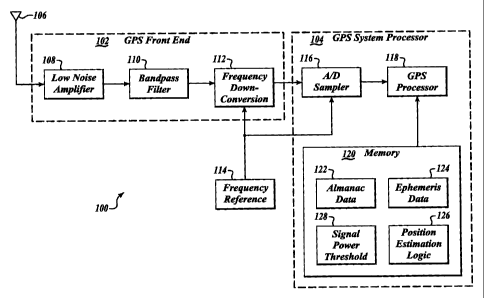
[0007] FIGURE 1 is a simplified block diagram of a Global Navigation
Satellite System (GNSS) device embodiment;
[0008] FIGURE 2 is a block diagram illustrating a GNSS satellite signal
correlation process using an Fast Fourier Transform (FFT) analysis process;
- 3 ¨
H000-1-1426AP 10-Claim
110017525
CA 02654142 2009-02-17
100091 FIGURE 3 is a conceptually illustrative three dimensional view
of a plurality of frequency bins corresponding to a detected GNSS satellite
signal;
100101 FIGURE 4 is a conceptually illustrative three dimensional view
of a reduced number of frequency bins that are searched during the GNSS
satellite
signal acquisition process;
100111 FIGURE 5 is a conceptually illustrative three dimensional view
of frequency bins that are searched during the GNSS satellite signal
acquisition
process after adjustment of a signal strength threshold by an embodiment of a
GNSS device; and
10012] FIGURE 6 is a conceptually illustrative three dimensional view
of fmer resolution frequency bins that are searched during the GNSS satellite
signal acquisition process.
DETAILED DESCRIPTION OF THE PREFERRED EMBODIMENT
100131 Embodiments of a Global Navigation Satellite System (GNSS)
device 100, such as the Global Positioning System (GPS) device, uses estimated
satellite orbital position information obtained from almanac and/or ephemeris
data
for setting signal strength threshold, so that GNSS satellite signal
acquisition
times are reduced. The almanac and/or ephemeris data may be retrieved from
memory or received in a detected satellite signal. The GNSS device 100 may be
interchangeably referred to as a GPS device, satellite position detection
device, or
the like.
[0014] FIGURE 1 is a simplified block diagram of a GNSS device
embodiment. The GNSS device 100 includes a GNSS front end 102 and a GNSS
processor system 104.
- 4 ¨
H000-1-1426AP 10-Claim
H0017525
CA 02654142 2009-02-17
[0015] The GNSS front end 102 receives the incoming analog GNSS
satellite signal from a GNSS antenna 106, which detects signals from a
plurality
of visible GNSS satellites. The analog GNSS satellite signal is amplified by a
low
noise amplifier 108 and is filtered by a bandpass filter 110. The low noise
amplifier 108 and the bandpass filter 110 may be provided in multiple stages,
if
desired.
[0016] The analog GNSS satellite signal at the output of the bandpass
filter 110 is downconverted in a frequency downconverter 112 by mixing the
analog GNSS satellite signal with a local oscillator signal to shift the
carrier
frequency of the incoming analog GNSS satellite signal to a lower and more
manageable frequency band. This downconversion can be performed multiple
times to bring the frequency of the analog GNSS satellite signal down in steps
to
the final desired frequency. Each mixing operation produces a high frequency
information band along with the lower frequency band. Therefore, each mixing
stage of the frequency downconverter 112 may require a bandpass filter to
remove
the information in the corresponding higher frequency band. A frequency
reference 114 provides a frequency reference for the frequency downconverter
112.
[0017] The GNSS processor system 104 includes an analog to digital
(AID) sampler 116 which, in response to the signal from the frequency
reference
114, converts the downconverted analog GNSS satellite signal to a digital GNSS
satellite signal. A GNSS processor 118 uses the downconverted digital GNSS
signal to first determine ranging and satellite information for the GNSS
satellites
in view of its antenna at the time, and to then determine latitude, longitude,
altitude, and/or GNSS system time.
- 5 ¨
H000-1-1426AP 10-C1alm
H0017525
CA 02654142 2015-11-24
[0018] Acquisition and tracking can be performed by the GNSS
processor 118 in software. Acquiring and tracking the GNSS satellite signals
principally means that the code and frequency offsets between GNSS satellites
and GNSS device 100 are determined and tracked on a regular basis. A typical
value of how often the tracking loops execute is 1000 times per second. GNSS
satellite position is determined from these offsets, but it can be done faster
or
slower depending on the processing capability available in the GNSS receiver.
[0019] A GNSS satellite transmits a signal that is detected by the GNSS
device 100. The transmitted GNSS signal from each GNSS satellite is modulated
with a psuedo-noise (PN) code that is a sequence of 1023 chips. Further, the
GNSS satellite signal is modulated by an additional data stream which contains
almanac data and the ephemeris data.
[0020] The PN code in the received GNSS satellite signal is periodically
repeated. The GNSS device 100 generates a plurality of replica PN codes at
many
different frequencies, which are compared with the received GNSS satellite
signal
using a correlation process. Fast Fourier Transform (FFT) techniques are used
to
facilitate the correlation process. An exemplary HT process is described in
U.S.
Patent publication 2007/0046536 to Zhike et. al, entitled "Fast Fourier
Transform
with Down Sampling Based Navigational Satellite Signal Tracking".
Any suitable GNSS satellite tracking system that
analyzes signals using a plurality of frequency bins may use embodiments
described herein to more quickly and/or more accurately acquire a GNSS
satellite
signal.
100211 The FFT analysis process correlates the GNSS satellite signal
information to generate correlation values that are stored into a series of
frequency
- 6 -
CA 02654142 2009-02-17
bins over a time range. The GNSS satellite signal will have its unique PN code
corresponding to at least one particular frequency bin. Thus, the PN signal
corresponds to at least one of the frequency bins that are searched by the
GNSS
device 100 during the GNSS signal acquisition process. The PN code may be
detectable over a relatively small frequency range, and thus, the GNSS
satellite
signal may be detectable in several adjacent frequency bins depending upon the
frequency range of the frequency bins defined during the FFT analysis process.
[00221 Once the GNSS signal is "acquired" (when the frequency and
time of the GNSS satellite signal is identified by the correlation process),
the
GNSS processor 28 may determine its relative distance to the GNSS satellite.
When at least four GNSS satellite signals have been acquired, and the
corresponding GNSS satellite orbital positions determined, a least squared
error
triangulation process is used to determine the location of the GNSS device 100
relative to the GNSS satellites (GNSS position).
[0023] Since the position of the GNSS satellites are known relative to
the earth, the GNSS processor 118 determines latitude and longitude of the
GNSS
device 100. The GNSS processor 118 can also determine altitude (or depth) if
the
GNSS device 100 operates in three dimensional space. The GNSS processor 118
may further determine rate and GNSS system time from the acquired GNSS
signal.
[0024] As noted above, the GNSS data in a received GNSS satellite
signal is processed by the GNSS processor 118 in the frequency domain (instead
of the time domain). Frequency domain processing techniques use FFT for
Wavelet Multiresolution Analysis (WMA). Such software based GNSS signal
acquisition may be faster than hardware based signal acquisition, and software
- 7 -
H000-1-1426AP 10-Chum
H0017525
CA 02654142 2009-02-17
processing can eliminate much of the front end processing. However, while
frequency domain techniques used during signal acquisition are faster than
conventional time domain techniques, there will still be a discernable amount
of
time required to complete the computations required for GNSS satellite signal
acquisition. Thus, a delay can occur from the end of the batch data collection
and
the completion of the signal acquisition phase depending on the processor 118
speed.
[0025] The GNSS system processor 118 further includes a memory 120.
As noted above, the received GNSS satellite signal includes almanac data and
ephemeris data. The information in the received almanac data and/or ephemeris
data is saved into the almanac database 122 and/or ephemeris database 124
portions of memory 120 in a suitable format, such as in a database or table.
Coarse
satellite orbital position information for a plurality of GNSS satellites
resides in
the almanac database 122. More accurate satellite orbital position information
resides in the ephemeris database 124. Other embodiments may store the
received
almanac data and/or ephemeris data in other formats, memory regions, or even
in
other memory devices.
[0026] The GNSS estimation logic 126 is software stored in memory
120 that is used to estimate GNSS satellite positions. One skilled in the art
will
appreciate that the GNSS estimation logic 126 can be stored on any computer-
readable medium for use by or in connection with any computer and/or processor
related system or method. The GNSS position estimation logic 126 (retrieved
and
executed by the GNSS processor 28) estimates orbital position of selected
visible
GNSS satellites based upon the satellite orbital position information in the
almanac database 122 and/or the ephemeris database 124.
- 8 -
H000-1-1426AP 10-Claim
H0017525
CA 02654142 2009-02-17
=
100271 Almanac data and ephemeris data is transmitted in portions in the
GNSS satellite signals, and accordingly, some period of time is required to
receive
a complete set of almanac data and ephemeris data. Relatively recently
acquired
almanac data and ephemeris data is saved into the almanac database 122 and the
ephemeris database 124, respectively, of memory 120. The receipt dates and
times
of the almanac and ephemeras data is also saved such that as assessment of the
validity of the almanac data and the ephemeris data may be made by the GNSS
processor 118 during the GNSS signal acquisition process. That is, the the
almanac database 122 and/or the ephemeris database 124 must be relatively
current for estimation of GNSS satellite orbital positions relative to the
location of
the GNSS device 100. Any suitable process for estimating the orbital position
of a
GNSS satellite relative to the GNSS device 100 may be used by the various
embodiments of the GNSS device 100.
100281 Accordingly, if information in the almanac database 122 and/or
the ephemeris database 124 is to be used to estimate GNSS satellite orbital
positions with a suitable degree of accuracy, then the information in the
almanac
database 122 and/or the ephemeris database 124 must be relatively current. In
one
embodiment, a coarse satellite orbital position is estimated based upon the
almanac information in the almanac database 122. Alternatively, a higher
accuracy satellite orbital position may be estimated based upon the
information in
the ephemeris database 124. An estimate of current time may be required for
either estimation.
[0029] However, if the information in the almanac database 122 and/or
the ephemeris database 124 is not current, and/or an estimate of current time
is not
available, the estimated orbital positions of the GNSS satellites may be
relatively
- 9 -
H000-1-1426AP 10-Clem
H0017525
CA 02654142 2009-02-17
inaccurate such that the signal acquisition process will not be able to
utilize
features of the various embodiments described herein. In such situations, the
GNSS satellite signal acquisition process is performed using legacy GNSS
signal
acquisition techniques.
[0030] Once the GNSS processor 118 has estimated the orbital position
for at least one visible GNSS satellite, embodiments of the GNSS device 100
use
the estimated satellite orbital position information to adjust at least one
parameter
used in the FFT analysis of the detected GNSS satellite signal. One or more
signal
processing parameters may be adjusted by the various embodiments of the GNSS
device 100.
[0031] Additionally, or alternatively, some embodiments of the GNSS
device 100 use a signal threshold 128 parameter. The signal threshold 128 is a
predefined parameter that is initialized during startup of the GNSS device
100.
The signal threshold 128 is used to distinguish incoming weak signals, and/or
signals with high levels of noise, from an incoming GNSS satellite signal.
[0032] In the various embodiments, the signal threshold 128 is an
adjustable signal power threshold value, and/or is an adjustable signal-to-
noise
threshold value. Based upon the estimated orbital position of the GNSS
satellite,
the received signal strength and/or signal-to-noise (SN) ratio may be
estimated for
a signal emitted by the GNSS satellite. For example, a signal emitted from a
GNSS satellite in an orbital position near the horizon will be significantly
attenuated and/or distorted by the earth's atmosphere. On the other hand, a
signal
emitted from a GNSS satellite in an orbital position that is substantially
overhead
will be less attenuated and/or distorted by the earth's atmosphere.
- 10 ¨
H000-1-1426AP 10-4Tlann
H0017525
CA 02654142 2009-02-17
[0033] Based on the estimated power and/or SN ratio, GNSS satellite
signals that have characteristics corresponding to the estimated power and/or
SN
ratio can be readily identified. For example, in a plurality of frequency bins
generated by the FFT analysis process, a frequency bin corresponding to the
GNSS satellite will have a discernable correlation peak (a relatively high
acquisition value, for example). Such frequency bins can be identified by
their
correlation peaks. Thus, an estimate is made to determine how much taller the
correlation peak should be over the expected noise.
[0034] The signal power threshold and/or SN ratio threshold may be
adjusted based on an estimated signal strength or an expected SN ratio that is
determined from the estimated orbital position of the GNSS satellite.
Accordingly,
frequency bins having a corresponding signal strength greater than the
adjusted
signal strength threshold, or having a SN ratio greater than the SN ratio
threshold,
are identified during the GNSS satellite signal acquisition process. The
identified
frequency bins are then used for the GNSS satellite signal acquisition
process.
[0035] FIGURE 2 is a block diagram illustrating a GNSS satellite signal
correlation process using an FFT analysis process. The incoming digitized and
downconverted GNSS satellite signal [r(n)] is processed by the GNSS system
processor 104 (FIGURE 1) using FFT techniques over a range of frequencies (f1,
f2, fk). At each
particular frequency, the GNSS satellite signal r(n) is
multiplied by cosine and sine functions. An FFT is computed of that mixed
signal.
The resultant FFT is then multiplied by the complex conjugate of the replica
code
for the satellite being searched at each frequency being searched. This
previously
determined complex conjugate FFT is retrieved from a look-up table or the
like.
The resulting complex conjugate is further processed by computing the inverse
- 11 ¨
H000-1-1426AP 10-Claim
H0017525
CA 02654142 2009-02-17
FFT (iFFT) to derive a magnitude value for each of the selected frequencies.
The
value is then stored in a frequency bin.
100361 FIGURE 3 is a conceptually illustrative three dimensional view
of a plurality of frequency bins 300 corresponding to a detected GNSS
satellite
signal. Most of the frequency bins 302 have a relatively low numerical value
of
the acquisition ratio. The numerical values of the acquisition ratio
correspond to
the degree of correlation between the signal hypothesis generated by the GNSS
device 100 and the received GNSS satellite signal. The low numerical values of
the acquisition ratio indicates detected noise or the like in the GNSS
satellite
signal for that particular frequency bin.
100371 However, some of the frequency bins 304 have a very high value
for its acquisition ratio. Here, the high value of the acquisition ratio
corresponds to
those frequency bins 304 that identify the frequency and time of the detected
GNSS satellite signal. Legacy GNSS devices search the entire set of frequency
bins 300 looking for the frequency bins 304. It is appreciated that such a
search
process, which unnecessarily includes processing of information in the
frequency
him 302, is very time consuming.
100381 One adjustable parameter is the number of frequency bins (and/or
their respective location in a matrix) processed during the GNSS satellite
signal
acquisition process. FIGURE 4 is a conceptually illustrative three dimensional
view of a reduced number of frequency bins that are searched during the GNSS
satellite signal acquisition process performed by an embodiment of the GNSS
device 100. For example, one embodiment deselects some or all of the frequency
bins 302 that are not expected to contain information corresponding to the
GNSS
- 12 -
H000-1-1426AP 10-Clmm
H0017525
CA 02654142 2009-02-17
satellite signal. For example, identified ones of the frequencies fl to fk
(FIGURE
2) may be deselected or the like.
100391 Frequency bins that are deselected are identified based upon the
estimated location of the GNSS satellite. The entire range of searchable
frequency
bins correspond to a range of possible locations of the GNSS satellite that is
being
acquired. For example, if the almanac data and/or ephemeris data is used to
estimate that the GNSS satellite is directly overhead, it is appreciated that
frequency bins corresponding to positions other than substantially overhead do
not
need to be searched. Thus, embodiments of the GNSS device 100 deselect those
frequency bins that do not correspond to a substantially overhead position.
[0040] One embodiment estimates location of the GNSS satellite based
upon the almanac data and/or ephemeris data. The embodiment identifies a
predefined range of frequency bins about the frequency bin(s) that corresponds
to
the estimated location. Bins outside of that range ore deselected.
[0041] Thus, frequency bins are screened out, deleted, or otherwise
identified as frequency bins that do not need to be processed during the GNSS
satellite signal acquisition process. Accordingly, a reduced number of
frequency
bins 402 are processed by the GNSS device 100 during the GNSS satellite signal
acquisition process. Another embodiment may select frequencies for a plurality
of
frequency bins that are expected to include the frequency bins 304. For
example,
selected ones of the frequencies fi to fk (FIGURE 2) may be selected. Thus,
signal
acquisition frequency bins are selected for processing during the GNSS
satellite
signal acquisition process.
[0042] In another embodiment, the above-described signal threshold 128
(FIGURE 1) may be adjusted based upon the expected characteristics of the
- 13 -
H000-1.1426M10-Clan
H0017525
CA 02654142 2009-02-17
GNSS satellite signal. FIGURE 5 is a conceptually illustrative three
dimensional
view of frequency bins that are searched during the GNSS satellite signal
acquisition process after adjustment of a signal strength threshold 502 by an
embodiment of a GNSS device 100. The signal strength threshold 502 may be
used to effectively screen out signals having signal strengths less than the
threshold. As noted above, frequency bins which correspond to the acquired
GNSS satellite signal have a discernable numerical value of the acquisition
ratio.
Other frequency bins that do not correspond to the GNSS satellite signal have
no,
or relatively small, numerical values for its acquisition ratio and can be
identified.
Such frequency bins are screened out, deleted, or otherwise identified as
frequency bins that do not need to be processed during the GNSS satellite
signal
acquisition process.
100431 In the exemplary frequency bins illustrated in FIGURE 5, the
signal strength threshold 502 has been adjusted such that frequency bins 504
having information corresponding to a signal strength less than the signal
strength
threshold 502 have been screened out, deleted, or otherwise identified as
frequency bins that do not need to be processed during the GNSS satellite
signal
acquisition process. Some frequency bins 506 may have corresponding numerical
values of their acquisition ratio that exceeds the signal strength threshold
502.
These frequency bins 506 are selected for processing. In one embodiment, other
screening processes or techniques may be used to screen out, delete, or
otherwise
identify some of these remaining frequency bins 506 as frequency bins that do
not
need to be further processed during the GNSS satellite signal acquisition
process.
100441 The frequency bins 304 corresponding to the GNSS satellite
signal are identifiable by their acquisition ratio numerical values which
- 14 ¨
H000-1-1426AP 10-Clam
H0017525
CA 02654142 2009-02-17
correspond to having a signal strength that is greater than or equal to the
signal
strength threshold 502. Accordingly, the frequency bins 304 are readily
identifiable. These frequency bins 304 may be selected for processing by the
GNSS device 100 during the GNSS satellite signal acquisition process.
[0045] FIGURE 6 is a conceptually illustrative three dimensional view
of finer resolution frequency bins 602 that are searched during the GNSS
satellite
signal acquisition process. When orbital position of a GNSS satellite is
estimated
using the almanac database 122 and/or the ephemeris database 124, as noted
above, frequency bins that are expected to contain information corresponding
to
the GNSS satellite signal may be identified. Such bins are identifiable by
their
time and by frequency. An alternative embodiment of the GNSS device 100 uses
this information to construct higher resolution frequency bins 602. That is,
the
number of frequency bins 602 that are processed remains the same, or at least
remain at a relatively large number compared to the number of bins 402 (FIGURE
4). However, each frequency bin 602 corresponds to a narrower time period
and/or a narrower frequency range. For example, the total frequency range of
the
processed frequency bins 602 is from 1.0415 x 10⁷ Hz to 1.0420 x 10⁷ Hz. In
contrast, the the total frequency range of the processed frequency bins 300
(FIGURE 3) is from 1.0415 x 10⁷ Hz to 1.0425 x 10⁷ Hz. Thus, the frequency
range of each frequency bin 602 is half of the frequency range of the
frequency
bins 300 (FIGURE 3).
100461 Adjusting the time period and/or a frequency range so that the
frequency bins have a higher resolution allows identification of the GNSS
satellite
signal with greater precision. Thus, the satellite's orbital position can be
determined with a greater accuracy. Further, during the subsequent tracking
- 15 ¨
H000-1-1426AP 10-Claim
H0017525
CA 02654142 2009-02-17
process, the GNSS satellite signal may be more accurately tracked since its
signal
has been located with a higher degree of accuracy by using the higher
resolution
frequency bins 602 that correspond to a smaller time period and/or frequency
range.
- 16 ¨
H000-1-1426AP 10-Claim
H0017525