Note: Descriptions are shown in the official language in which they were submitted.
CA 02663049 2009-03-10
WO 2008/039679 PCT/US2007/078974
1
METHOD AND SYSTEM FOR DISPLAYING GRAPHICAL OBJECTS ON A
DIGITAL MAP
TECHNICAL FIELD OF THE INVENTION
This invention relates generally to digital maps,
and more particularly, to a method and system for
displaying graphical objects on a digital map.
BACKGROUND OF THE INVENTION
Digital maps have been developed to search for,
identify, and discover information about geographic
locations. Some mapping programs generate digital maps
using satellite imagery. Examples of such mapping
programs include Google Earth and Microsoft's Virtual
Earth. Such existing mapping programs typically provide
a base digital map along with simple lines to draw simple
graphics and annotations to describe map features. These
existing mapping programs, however, do not natively
support the display of more complicated 2D and 3D
graphical objects.
OVERVIEW OF EXAMPLE EMBODIMENTS
According to one embodiment of the invention, a
method for displaying graphical objects on a digital map
includes receiving, for a graphical object, metadata
comprising a parameter indicating a type of the graphical
object, a parameter indicating a size of the graphical
object, and a group of parameters indicating a geographic
location of the object represented by the graphical
object. The type of the graphical object is one of a
group of stored types. The method further includes
rendering the graphical object on the digital map by
generating, based on the received metadata, a group of
geographic coordinates for the graphical object.
CA 02663049 2009-03-10
WO 2008/039679 PCT/US2007/078974
2
Technical advantages of particular embodiments of
the present invention include a method and system for
displaying graphical objects on a digital map that
generates markup language code from simple metadata
describing the graphical object. Thus, development time
and software maintenance costs to render the graphical
objects are dramatically reduced.
Another technical advantage of particular
embodiments of the present invention includes a method
and system for displaying graphical objects on a digital
map that automatically retrieves graphical object
information through a subscription mechanism. Thus, the
present invention dynamically updates the graphical
objects in real time.
Other technical advantages of the present invention
will be readily apparent to one skilled in the art from
the following figures, descriptions, and claims.
Moreover, while specific advantages have been enumerated
above, various embodiments may include all, some, or none
of the enumerated advantages.
BRIEF DESCRIPTION OF THE DRAWINGS
For a more complete understanding of the present
invention and its features and advantages, reference is
now made to the following description, taken in
conjunction with the accompanying drawings, in which:
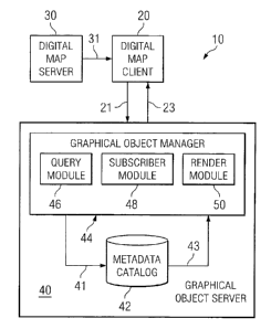
FIGURE 1 is a block diagram illustrating a system
for displaying graphical objects on a digital map
according to the teachings of the invention;
FIGURE 2 is a representative image illustrating
graphical objects on a digital map in accordance with an
embodiment of the present invention; and
CA 02663049 2009-03-10
WO 2008/039679 PCT/US2007/078974
3
FIGURE 3 is a flow chart illustrating example acts
associated with a method for displaying graphical objects
on a digital map.
DESCRIPTION OF EXAMPLE EMBODIMENTS
Embodiments of the present invention and its
advantages are best understood by referring to FIGURES 1
through 3 of the drawings, like numerals being used for
like and corresponding parts of the various drawings.
FIGURE 1 is a block diagram illustrating a system 10
for displaying graphical objects on a digital map
according to the teachings of the invention. As shown in
FIGURE 1, system 10 generally includes a digital map
client 20, a digital map server 30, and a graphical
object server 40. System 10 is particularly adapted for
displaying graphical objects on a digital map.
Digital map client 20 may refer to any suitable
device operable to display a digital map. A digital map
may refer to any computerized representation of a
geographic area that can be displayed and analyzed by a
computer. For example, the most common method of digital
map creation is digitization, where a hardcopy map is
transferred into a digital medium through the use of a
computer program and geographic information. As another
example, a digital map may be generated by converting
existing digital information, which may not yet be in map
form, into forms a computer can recognize and use. Thus,
digital satellite images generated through remote sensing
may be combined to produce a map-like layer of digital
information, resulting in a flat projection of the
earth's surface.
In particular embodiments of the invention, digital
map client 20 may be operable to execute an application,
CA 02663049 2009-03-10
WO 2008/039679 PCT/US2007/078974
4
such as Google Earth, that allows a user to interact with
a digital map. Google Earth is an application that maps
the earth by combining images obtained from satellite
imagery. By entering the appropriate commands, a user
may instruct Google Earth to "zoom" to a lower relative
viewing position, such that Google Earth displays a
digital map of a smaller geographical area that is shown
at a higher degree of resolution. Google Earth also
allows the user to "scroll" or "fly" to a different
lateral position on the digital map. In other
embodiments of the invention, digital map client 20 may
be operable to execute other applications, such as
Microsoft's Internet Explorer browser, that allows a user
to interact with a digital map through the Internet.
Digital map client 20 may execute with any of the
well-known MS-DOS, PC-DOS, OS-2, MAC-OS, WINDOWSTM, UNIX,
or other appropriate operating systems, including future
operating systems. Digital map client 20 may include,
for example, a personal digital assistant, a computer
such as a laptop, a cellular telephone, a mobile handset,
or any other device operable to display a digital map.
Digital map server 30 may refer to any suitable
device operable to deliver a digital map, images,
scripting languages, and other static elements that are
sent to digital map client 20, as indicated by reference
number 31.
According to a particular embodiment of the
invention, digital map server 30 may include software
operable to facilitate a tile serving system operable to
deliver individual digital map tiles in response to
requests from digital map client 20. For example,
digital map server 30 may organize mapping data into a
hierarchy of successive magnitudes for presentation of
CA 02663049 2009-03-10
WO 2008/039679 PCT/US2007/078974
the mapping data with variable resolution, starting from
a first highest magnitude with lowest resolution and
progressing to a last magnitude with highest resolution.
Thus, the tile serving system may have fewer tiles at the
5 top, and each successive descending level may contain
four times as many tiles as the level directly above it.
This software may properly interface with corresponding
software provided in digital map client 20.
Alternatively, digital map server 30 may include any
other suitable software operable to deliver individual
map tiles in response to requests from digital map client
20.
Graphical object server 40 represents any suitable
device operable to render graphical objects for display
on a digital map at digital map client 20. Although
FIGURE 1 provides one example of graphical object server
40 as operating separate from digital map server 30, in
other embodiments graphical object server 40 may operate
within digital map server 30. In yet other embodiments,
digital map client 20, digital map server 30, and
graphical object server 40 may operate within the same
server. Additional details of one example of graphical
object server 40 are described in more detail below.
In various embodiments of the invention, existing
mapping programs, such as Google Earth, may provide a
markup language to display points and lines on the
digital map. A markup language refers to a language that
has code that indicates layout, styling, and placement of
graphics. Keyhole Markup Language (KML) is one such
markup language for managing geographic data on Google
Earth. A KML document may contain code describing a
basic feature along with latitude and longitude
coordinates of the feature. For example, a placemark,
CA 02663049 2009-03-10
WO 2008/039679 PCT/US2007/078974
6
such as the location of a state capital, may be defined
along with a representative icon in a KML document.
However, existing mapping programs, such as Google Earth,
are generally limited to displaying simple lines using
the markup language, and do not natively support the
display of more complicated 2D and 3D graphical objects.
According to one embodiment of the invention, a
system and method are provided that display complex
graphical objects on a digital map. This is effected, in
one embodiment, by providing a mechanism to generate many
lines of markup language code from simple metadata
describing graphical objects. The markup language code
is then used to render graphical objects for display on a
digital map. Additional details of example embodiments
of the invention are described in greater detail below in
conjunction with portions of FIGURE 1, FIGURE 2, and
FIGURE 3.
According to the illustrated embodiment of the
invention, graphical object server 40 includes a metadata
catalog (MDC) 42 and a graphical object manager 44. In
the illustrated embodiment MDC 42 resides within
graphical object server 40; however, in other
embodiments, MDC 42 may reside on a separate server.
MDC 42 may refer to any suitable device operable to
store metadata, and facilitate addition, modification,
and retrieval of such metadata. In general, metadata is
data that describes other data. In the context of MDC
42, MDC 42 stores metadata as descriptive data about the
graphical objects to be displayed. In accordance with a
particular embodiment of the present invention, MDC 42
may utilize a relational database management system to
store metadata, making metadata available and accessible
through an easy to use, well understood access language,
CA 02663049 2009-03-10
WO 2008/039679 PCT/US2007/078974
7
such as Structured Query Language (SQL). In other
embodiments, MDC 42 may utilize other metadata management
systems.
According to one embodiment, MDC 42 may locally
store metadata corresponding to a graphical object type
to be displayed on a digital map. A graphical object
type may refer to a name of any computer data capable of
being rendered on a computer in the form of an image,
such as a geometric object depicted in geometric space.
For example, MDC 42 may store a type value specifying a
type of 3D graphic, such as an ellipsoid, to be displayed
at a particular location. In other embodiments, a
graphical object type may refer to a name of any digital
photograph, diagram, icon, symbol, or other data capable
of being rendered on a computer in the form of an image.
For example, MDC 42 may store a type value specifying a
type of icon, such as a military symbol, to be displayed
at a particular location.
MDC 42 may locally store metadata corresponding to
geographic locations of graphical objects to be displayed
on a digital map, according to one embodiment of the
invention. For example, MDC 42 may store a latitude, a
longitude, and an altitude value describing a center
point for a 3D graphic, such as an ellipsoid, to be
displayed. As another example, MDC 42 may store a
latitude, a longitude, and an altitude value describing a
center point for a symbol, such as a military symbol, to
be displayed.
According to one embodiment, MDC 42 may locally
store metadata corresponding to size descriptions of
graphical objects to be displayed on a digital map. For
example, MDC 42 may store a width, a height, and a length
value describing a size for a 3D graphic, such as an
CA 02663049 2009-03-10
WO 2008/039679 PCT/US2007/078974
8
ellipsoid, to be displayed. As another example, MDC 42
may store a radius value describing a size for a 2D
graphic, such as a circle, to be displayed.
Table 1 is an example document with document tags
populated with properties for a graphical object that may
be stored as metadata in MDC 42, in accordance with an
embodiment of the present invention. A tag may refer to
any marker embedded in a document that indicates data
contained within an element. For example, in Table 1,
line 1 the first tag indicates that the document is an
Extensible Markup Language (XML) document. XML refers to
a flexible syntax for describing data. Based on data
type definition (DTD) files and XML Schema language
files, clients, such as administrators or automated
scripts, may create a document with XML tags. The self-
describing XML tags map to information associated with
the various graphical objects. However, other documents
could equally be employed in alternative embodiments.
For example, the documents may be, for example, a
standard ASCII text file with some proprietary format, an
HTML file, or other suitable document.
In Table 1, line 2 indicates a latitude, a
longitude, and an altitude value describing a center
point for a graphical object. Line 3 of Table 1
indicates a type value specifying a type of graphical
object, an ellipsoid, along with a width, a height, and a
length value describing a size of the ellipsoid.
CA 02663049 2009-03-10
WO 2008/039679 PCT/US2007/078974
9
Table 1: Sample Document
1 <?xml version="1.0" encoding="UTF-8"?>
2 <render latitude="33.30605940552157"
longitude="44.32823403459573"
altitude="0">
3 <geo:ellipsoid width="300" length="300" height="300"/>
4 </render>
However, the present disclosure contemplates many types
of graphical object properties. Various embodiments may
include, some, all, or none of the enumerated properties.
Graphical object manager 44 may refer to any
suitable logic embodied in computer-readable media, and
when executed, that is operable to render graphical
objects for display on digital map client 20. In the
illustrated embodiment of the invention, graphical object
manager 44 resides on graphical object server 40. In
other embodiments of the invention, graphical object
manager 44 may reside on digital map client 20, or any
other suitable device operable to connect to MDC 42.
According to the illustrated embodiment of the
invention, graphical object manager 44 includes various
modules operable to perform various functions including a
query module 46, a subscriber module 48, and a render
module 50.
According to one embodiment of the invention, query
module 46 may query MDC 42 for metadata, as indicated by
reference number 41. In particular embodiments of the
invention, query module 46 may query MDC 42 for any type
of metadata, such as location metadata, graphical object
metadata, status metadata, or any other suitable
metadata. Query module 46 may query MDC 42 for metadata
CA 02663049 2009-03-10
WO 2008/039679 PCT/US2007/078974
that match specified criteria. For example, the
specified criteria used by query module 46 may include
spatial criteria. Spatial criteria may specify location
properties, such as latitude and longitude values, as a
5 search filter for the graphical object metadata. As
another example, the specified criteria used by query
module 46 may include contextual criteria. Contextual
criteria may specify patterns, such as string patterns,
as a search filter for the graphical object metadata. As
10 another example, the specified criteria used by query
module 46 may include temporal criteria. Temporal
criteria may specify time properties, such as a last
modified date, as a search filter for the graphical
object metadata. However, the present disclosure
contemplates many types of query criteria. Various
embodiments may include, some, all, or none of the
enumerated query criteria.
Query module 46 may query MDC 42 for graphical
object metadata using Java Server Pages (JSP), according
to one embodiment of the invention. JSPs may utilize
tags to generate a definable markup language. When
executed by a JSP container, the definable markup
language may generate a result in various formats, such
as XML. For example, according to the runtime behavior
of a JSP container, the opening element of query tag is
interpreted and loaded into the system memory. Any
properties specified in the tag will be loaded at
runtime. Next, the JSP container interprets all nested
child-tags, and the contents of their bodies are
translated, and then passed back to the parent query tag.
At this point, the parent query tag has the criteria it
needs to query MDC 42.
CA 02663049 2009-03-10
WO 2008/039679 PCT/US2007/078974
11
According to one embodiment of the invention, search
criteria, collected by query module 46, from the nested
tags may be consolidated and passed to MDC 42. In other
embodiments, query module 46 may query MDC 42 without
search criteria. Results from MDC 42 from query module
46 loaded into a collection object. By retrieving the
collection object produced by the query tag, the JSP may,
at runtime, generate a developer-defined markup language
document, such as the document in Table 1.
According to one embodiment of the invention,
subscriber module 48 may subscribe to MDC 42 to receive
continuous updates to metadata from MDC 42, as indicated
by reference number 43. Subscriber module 48 may
subscribe to MDC 42 for metadata that match specified
criteria. For example, the specified criteria used by
subscriber module 48 may include spatial criteria as
described above. As another example, the specified
criteria used by subscriber module 48 may include
contextual criteria as described above. As another
example, the specified criteria used by subscriber module
48 may include temporal criteria as described above.
However, the present disclosure contemplates many types
of subscription criteria. Various embodiments may
include, some, all, or none of the enumerated
subscription criteria.
Subscriber module 48 may subscribe to MDC 42 to
receive continuous updates to metadata from MDC 42 using
JSPs, according to one embodiment of the invention. For
example, a user session, at digital map client 20, may be
retrieved from a JSP container and a lookup may performed
on a"subld" property. A"subId" property refers to a
unique identifier to store and locate MDC 42 subscriber
instances within the user session. If an.instance is
CA 02663049 2009-03-10
WO 2008/039679 PCT/US2007/078974
12
found, the subscribe process continues. If not, a new
instance is generated. The instance is bound to the
user's session supplied by the JSP container.
For any updates to metadata in MDC 42, subscriber
module 48 may receive updates for each user session. The
subscription results are loaded into a collection object.
The collection object is then bound to the user session.
By retrieving the collection object produced by the query
tag, the JSP may, at runtime, generate a developer-
defined markup language document, such as the document in
Table 1.
According to one embodiment of the invention, render
module 50 receives metadata and renders the metadata into
a markup language for display on a digital map. For
example, render module 50 may identify a graphical object
type to be displayed from the received metadata. The
graphical object type may be a 3D graphic, such as an
ellipsoid, to be displayed on a digital map.
Render module 50 may use the received object type
metadata to generate a model representing the graphical
object, according to one embodiment of the invention.
For example, render module 50 may generate an ellipsoid
model for a particular graphical object type. To
generate the model, render module 50 may input ellipsoid
properties from the metadata, such as length, width, and
height into an ellipsoid generating algorithm. The
ellipsoid generating algorithm may generate the
coordinates of the vertices of the ellipsoid model in
Cartesian coordinates. As an example, and not by way of
limitation, Table 2 illustrates an ellipsoid generating
algorithm.
CA 02663049 2009-03-10
WO 2008/039679 PCT/US2007/078974
13
Table 2: Sample Algorithm for Ellipsoid
1 raw Ellipsoid Centered at (0,0,0) {
2 resolution = props.resolution
3 length = ellipsoid.length
4 width = ellipsoid.width
height = ellipsoid.height
6 step = (2*PI) / resolution
7 vstep = PI / resolution
8 a = width / 2
9 b = length / 2
c = height / 2
11 for (i = 0; i < resolution; i++)
12 for (j = 0; j < resolution; j++)
13 ang = (i * step)
14 vang = (j * vstep)
x = a * cos(ang )* sin(vang)
16 y = b * sin(ang) * sin(vang)
17 z = C * cos (ang)
18 points [i] [j ] = (x, y, z)
19 if (i > 0 and j > 0)
faces [i-1] [j -1] =
{points [i-1] [j ] ,points [i-1] [j -1] ,points [i] [j -
1] points [i] [j] }
21 for (j = 0; j <= resolution; j++)
22 if (j > 0)
23 faces [resolution-1] [j -1] =
{points [resolution-1] [j ] , points [resolution-1] [j - 11,
oints [0] [j -1] ,points [0] [j ] }
CA 02663049 2009-03-10
WO 2008/039679 PCT/US2007/078974
14
According to one embodiment of the invention, render
module 50 may apply rendering properties to the generated
coordinates of the model. For example, the properties
applied by render module 50 may include rotation and tilt
properties. Rotation properties may refer to properties
that rotate coordinates of a model along an axis. To
apply rotation along the z-axis, render module 50 may use
the following formula:
x = x.coordinate
y = (cos(rotation) * y.coordinate) + (sin(rotation) * z.coordinate)
z = (-sin(rotation) * y.coordinate) + (cos(rotation) * z.coordinate)
Tilt properties may refer to properties that tilt
coordinates of a model along a North/South axis and an
East/West axis. To apply tilt along the East/West axis,
render module 50 may use the following formula:
x = (cos(tiltE) * x.coordinate) + (-sin(tiltE) * z.coordinate)
y = (y.coordinate)
z = (sin(tiltE) * x.coordinate) + (cos(tiltE) * z.coordinate)
To apply tilt along the North/South axis, render module
50 may use the following formula:
x = (cos(tiltN) * x.coordinate) + (sin(tiltN) * y.coordinate)
y = (-sin(tiltN) * x.coordinate) + (cos(tiltN) * y.coordinate)
z = z.coordinate
According to one embodiment of the invention, render
module 50 may apply other rendering properties to the
generated coordinates of the model, such as scale,
altitude mode, resolution, and shadow properties. Scale
properties may refer to properties that determine a size
of a model. Altitude mode properties may refer to
properties that determine the model's relationship to the
ground. Resolution properties may refer to properties
that determine a number of line segments in the model.
Shadow properties may refer to properties that place a
CA 02663049 2009-03-10
WO 2008/039679 PCT/US2007/078974
corresponding shadow element below a model. However, the
present disclosure contemplates displaying many types of
rendering properties. Various embodiments may include
some, all, or none of the enumerated rendering
5 properties.
According to one embodiment of the invention, render
module 50 may convert the generated Cartesian coordinates
of the model into a polar coordinate representation. For
example, using the latitude, longitude, and altitude
10 values passed in the metadata, the following formulas may
be used by render module 50 to solve for the projected
latitude and longitude polar coordinates of the model
(latx/longx):
distance
earth's radius at (lat,long)
15 latx = asin(sin(lat) x cos(a) + cos(heading) x cos(lat) x sin(a))
longx = long + arctan sin(heading) x sin(a) x cos(lat)
cos(a) - sin(lat) x sin(latx)
In the example provided, lat and long represent the
center point of the model, distance represents the
distance of the model point to the model center, and
heading represents the angle of the model point measured
from North clockwise.
With the polar coordinate representation, render
module 50 may use the distance from the origin and angle
to the coordinates to render the coordinates on the
digital map using a markup language. A markup language
document may be created based on the projected latitude
(latx) and longitude (longx) coordinates of the model.
For example, common markup languages include Hyper Text
Markup Language (HTML) and KML. For example, a KML
document may specify graphical objects for display in a
CA 02663049 2009-03-10
WO 2008/039679 PCT/US2007/078974
16
digital map using KML nodes to represent the various
lines and coordinates of the graphical objects.
Table 3 is an example KML document that render
module 50 may generate for the graphical object of Table
1, in accordance with an embodiment of the present
invention. Lines 4-12 and lines 14-22 of Table 3
indicate the polygon information that make up the
portions of the 3D ellipsoid. Lines 8-9 and lines 18-19
of Table 3 indicate the coordinates of the points of the
respective polygons. The ellipsis at Line 13 of Table 3
indicates that many lines of polygon data may be
generated to render the 3D ellipsoid. Thus, the few
lines of tags from Table 1 may generate many lines of KML
content in Table 3.
CA 02663049 2009-03-10
WO 2008/039679 PCT/US2007/078974
17
Table 3: Sample KML Document
1 <?xml version="1.0" encoding="UTF-8"?>
2 <kml xmins="http://earth.google.com/kml/2.0">
3 <Placemark>
4 <MultiGeometry id="khMultiGeometry651">
<Polygon id="khPolygon652">
6 <altitudeMode>absolute</altitudeMode>
7 <outerBoundaryls>
8 <LinearRing id="khLinearRing653">
9 <coordinates>
44.32561414514183,33.31299791749765,149.178284305241
44.32555163679158,33.31297130128769,149.178284305241
44.32561414514183,33.31299791749765,149.178284305241
</coordinates>
11 </LinearRing>
12 </outerBoundaryIs>
13 </Polygon>
14...
<Polygon id="khPolygon1100">
16 <altitudeMode>absolute</altitudeMode>
17 <outerBoundaryIs>
18 <LinearRing id="khLinearRing1101">
<coordinates>
44.32591030599476,33.31419394884433,9.184850993605149
44.32524235027147,33.31415745737503,15.67926949014805
19 44.32591030599476,33.31419394884433,9.184850993605149
</coordinates>
21 </LinearRing>
22 </outerBoundaryIs>
23 </Polygon>
24 </MultiGeometry>
</Placemark>
26 </kml>
CA 02663049 2009-03-10
WO 2008/039679 PCT/US2007/078974
18
According to one embodiment of the invention, render
module 50 may send a document, such as the sample KML
document in Table 3, to digital map client 20 for
display, as indicated by reference number 23. For
example, digital map client 20 may communicate to
graphical object server 40 a particular location
currently displayed to a user, as indicated by reference
number 21. Render module 50 may receive a document, such
as the document in FIGURE 1, for a graphical object to be
displayed at the particular location. Render module 50
may render the document into a markup language document,
such as KML, and pass the markup language document to
digital map client 20 to display the graphical object at
the particular location.
FIGURE 2 is a representative image 110 illustrating
graphical objects on a digital map in accordance with an
embodiment of the present invention. As shown in FIGURE
2, image 110 generally includes a 2D circle object 120, a
3D sphere object 122, a 3D cone object 124, a 2D ring
object 126, a 3D cylinder object 128, a 3D box object
130, and a 3D hemisphere object 132. However, the
present disclosure contemplates displaying many types of
graphical objects. Various embodiments may include some,
all, or none of the enumerated graphical objects.
According to one embodiment of the invention, image
110 may be generated by using a markup language document,
such as KML, to draw graphic objects with wire frame and
triangular mesh lines of 2D and 3D objects. The
coordinates of the lines defining the objects may have
latitude, longitude, and altitude values stored in the
respective KML documents. The coordinates may be
generated from metadata describing the graphical objects
in terms of type, size, and location.
CA 02663049 2009-03-10
WO 2008/039679 PCT/US2007/078974
19
Image 110 may be generated by retrieving a base map
image for a specified location. The specified location
may be used to query a metadata catalog for graphical
objects at the specified location. Next, a model of each
graphical object at the specified location may be
generated with Cartesian coordinates. The Cartesian
coordinates may be converted into polar coordinates for
projection onto a digital map. A markup language
document, such as a KML document, may be generated based
on the converted coordinates. The KML document is used
by a digital map client to render the graphical objects
at the specified location. According to various
embodiments, a few lines of graphical object properties
may generate thousands of lines of KML code, depending on
the complexity of the graphical object to be displayed.
This approach significantly reduces development time and
software maintenance cost to generate similar results.
FIGURE 3 is a flow chart illustrating example acts
associated with a method for displaying graphical objects
on a digital map. The example acts may be performed by
graphical object manager 44, as discussed above with
reference to FIGURE 1. At step 302, graphical object
metadata may be received. In particular embodiments of
the invention, the received metadata may include a
graphical object type to be displayed on a digital map.
For example, the metadata catalog may store a type value
specifying an ellipsoid, to be displayed at a given
location. In particular embodiments of the invention,
the received metadata may include geographic locations of
graphical objects to be displayed at a particular
location. For example, the metadata catalog may store a
latitude, a longitude, and an altitude value describing a
center point for a 3D graphic, such as an ellipsoid, to
CA 02663049 2009-03-10
WO 2008/039679 PCT/US2007/078974
be displayed. In particular embodiments of the
invention, the received metadata may include size
descriptions of graphical objects to be displayed on a
digital map. For example, the metadata catalog may store
5 a width, a height, and a length value describing a size
for a 3D graphic, such as an ellipsoid, to be displayed.
At step 304, a model is generated based on the
received metadata. The type of the graphical object may
determine the algorithm used to generate the model. For
10 example, an ellipsoid model may be generated for a
particular graphical object type. To generate the model,
ellipsoid properties from the metadata, such as length,
width, and height may be applied to an ellipsoid
generating algorithm. The ellipsoid generating algorithm
15 may generate the coordinates of the ellipsoid model in
Cartesian coordinates.
At step 306, the coordinates of the model are
converted to project the coordinates on a digital map.
In particular embodiments of the invention, the generated
20 Cartesian coordinates of the model may be converted into
a polar coordinate representation. For example, using
the latitude, longitude, and altitude values in the
metadata, conversion formulas may be used to solve for
the projected latitude and longitude polar coordinates of
the model.
At step 308, the graphical object may be rendered
based on the converted coordinates. For example, with
the polar coordinate representation, the distance from
the origin and angle to the coordinates may be used to
project the coordinates on the digital map. A markup
language document may be created based on the projected
latitude (latx) and longitude (longx) coordinates. For
example, common markup languages include HTML and KML.
CA 02663049 2009-03-10
WO 2008/039679 PCT/US2007/078974
21
Thus, by providing size, center location, and type
metadata for a graphical object, geographic coordinates
may be generated in order to display the graphical object
on a digital map. For example, a KML document may be
used to define the graphical object using KML nodes to
associate the various lines and geographic coordinates
representing the graphical object.
Although the present invention has been described in
several embodiments, a myriad of changes, variations,
alterations, transformations, and modifications may be
suggested to one skilled in the art, and it is intended
that the present invention encompass such changes,
variations, alterations, transformations, and
modifications as falling within the spirit and scope of
the appended claims.