Note: Descriptions are shown in the official language in which they were submitted.
CA 02665993 2009-05-15
ATTM-1184/C07-219-000 PATENT
METHOD FOR GEO-TARGETING WIRELESS EMERGENCY ALERTS
TECHNICAL FIELD
[0001] The technical field generally relates to communications systems and
more
specifically relates to geo-targeting wireless emergency alerts.
BACKGROUND
[0002] Mobile device users may receive emergency alerts that are transmitted
by their
wireless network provider to their mobile device. The emergency alerts may be
broadcast via a
broadcast network. However it is difficult to send a unique message to a
particular area. For
example, not all of the mobile device users that receive the emergency alert
are in the geographic
area affected by the emergency event. Further, not all components in the
telecommunications
infrastructure in a particular geographic region, such as some cell towers,
are capable of
broadcasting emergency alerts.
[0003] The management of telecommunications capabilities is crucial during
disasters
that degrade the infrastructure, especially where the infrastructure may have
been minimal
beforehand. It is desirable to efficiently provide emergency alerts & warnings
to the greatest
number of people necessary without significantly adding load to the critical
network resources,
and to target the alerts & warnings to people in the geographical area that is
affected.
SUMMARY
[0004] Geo-targeting is a common tool for targeting information to a specified
geographical area. Geo-targeting may be used in combination with wireless
alert capabilities to
-1-
CA 02665993 2009-05-15
ATTM-1184/C07-219-000 PATENT
provide alerts to a more granulated geographical area. Described herein is a
system and method
for performing geo-targeting for various alert areas such that emergency
messages may be
delivered to mobile and static devices of different types in a localized area.
In an example
embodiment, geo-targeting supports the delivery area for wireless emergency
alerts by
identifying the cell sites that are in a specified geographic area that have
technology capable of
delivering wireless emergency alerts. Further, the components of the
telecommunications
system that support a wireless emergency alert system may be identified and
mapped across
different geographical levels (e.g., county, state, region). In this way,
mobile device users in the
affected geographical area may receive the emergency alerts targeted to that
geographical area.
BRIEF DESCRIPTION OF THE DRAWINGS
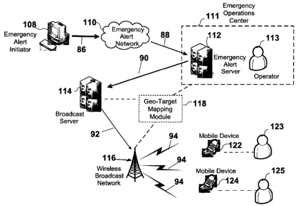
[0005] Figure 1 depicts a method and system for geo-targeting emergency alerts
to a
geographic area.
[0006] Figure 2 depicts a geo-target mapping methodology across various
geographic
areas (i.e., cell site, county, state, region).
[0007] Figure 3 depicts a geo-target mapping methodology for a specified
location (i.e.,
Location X)
[0008] Figure 4 depicts an overall block diagram of an exemplary packet-based
mobile
cellular network environment, such as a GPRS network, in which the system for
providing alert
messages based on a characteristic and/or configuration can be practiced.
[0009] Figure 5 illustrates an architecture of a typical GPRS network as
segmented into
four groups.
[0010] Figure 6 illustrates an example alternate block diagram of an exemplary
GSM/GPRS/IP multimedia network architecture in which alert messages based on a
characteristic and/or configuration can be incorporated.
DETAILED DESCRIPTION OF ILLUSTRATIVE EMBODIMENTS
[0011] A wireless network may augment a telecommunications system by
broadcasting
emergency messages from the telecommunications system to mobile stations
associated with the
wireless network. Disclosed herein is a method and system of incorporating geo-
targeting into a
telecommunications system such that mobile device users that are in an
affected geographical
area may receive notification of an emergency event. A geo-targeting mapping
module may
verify whether or not the telecommunications system that services a particular
geographic area is
capable of broadcasting emergency alerts. For example, the module may identify
the Cell Site
-2-
CA 02665993 2009-05-15
ATTM-1184/C07-219-000 PATENT
IDs in the geographic area that have broadcast technology, and what type of
broadcast
technology is supported in that geographic area.
[0012] The geo-target mapping module can provide broadcast capability
information for
a geographic area of any magnitude, small or large. Delivering alerts via the
geo-targeting
technique provides the capability of identifying a more granulated alerting
area based on the
emergency event. For example, if a shooting occurs on a college campus,
students within the
geographical limits of a college campus may receive the alerts on their mobile
device via geo-
targeting.
[0013] In the discussion that follows, details relating to mobile devices and
networks
are assumed to be well known. Accordingly, such details are largely omitted
herein for the sake
of clarity and explanation. In addition, any references herein to an example
embodiment
involving a cellular telephone is solely for purposes of explanation, and is
not intended to limit
the invention to any such embodiment. For example, a mobile device as
contemplated by
various embodiments of the invention may include, but are not limited to:
cellular telephones,
personal digital assistants (PDAs), email devices and the like. The mobile
device may operate in
a cellular, SMR, PCS, cordless, unlicensed AWS, 700 MHz, or other spectrums.
Furthermore,
embodiments are not limited by the network servicing the device. Accordingly,
embodiments
may be applicable to any network type including, for example, TDMA, CDMA,
WCDMA,
GSM, WiFi, WiMAX, OFDM, UMTS, EV-DO, HSDPA/HSUPA and other standards now
known or to be developed in the future.
[0014] An example system for distributing emergency alerts in the United
States is an
Emergency Alert System (EAS) that was implemented by the Federal Communication
Commission (FCC), National Weather Service (NWS), and Federal Emergency
Management
Administration (FEMA). The United States EAS is designed to provide messages
from multiple
origination points (e.g., county, state, federal). For example, the president
can use the EAS to
send a nationwide emergency alert message. The FCC provides information to
broadcasters,
cable system operators, and state and local emergency managers. The EAS
typically provides
messages indicative of a variety of types of alerts including, for example,
weather conditions,
disasters, America's Missing: Broadcast Emergency Response (AMBER) alerts,
and/or alerts
issued by the Government, for example. EAS messages may be provided to, for
example, a
mobile device of a user such that the EAS alert message may be broadcast to
the user via the
mobile device. Any references herein to an example embodiment involving the
EAS is solely for
-3-
CA 02665993 2009-05-15
ATTM-1184/C07-219-000 PATENT
purposes of explanation, and is not intended to limit the invention to any
such embodiment. Any
type of emergency alert system may use the disclosed techniques.
[0015] Figure 1 depicts an example EAS system that broadcasts emergency alerts
and
incorporates a geo-target mapping module 118. In this example, the wireless
broadcast network
116 is a cellular network and the mobile devices 124, 126 that may receive the
broadcast are
cellular telephones.
[0016] An alert message initiator 108 may generate and provide an EAS alert
message
at 86 to an emergency alert network 110. The alert message initiator 108 may
be, for example, a
first responder to a scene (e.g., fire fighter, police officer, emergency
medical technician, etc),
the local government, an agency (e.g., National Weather Service), an emergency
manager of an
entity (e.g., designated person in the emergency center of a hospital or
campus), an automated
system (e.g., a fire alarm, electronic sensors that detect toxic gas), an
Emergency Operations
Center (EOC), an on-site Incident Commander, public utility, or the like. For
example, there
may be an origination point at the federal level for national warnings, and a
designated
emergency manager may have the authorization to request that an emergency
alert be broadcast.
Counties and local governments may have their own emergency management
organization to
serve counties and local tribunals, with an emergency manager at the county or
local level that
has the authorization to initiate a request for transmission of an emergency
alert. Campuses may
have a point of contact to support emergency management for a university that
are authorized to
request transmission of emergency alerts. Depending on the level, different
levels of
authorization may be granted. The emergency manager may be limited to
requesting emergency
alert transmission to a select area.
[0017] The EAS alert message may contain information about the emergency
event,
such as location, severity, type, etc. The alert message may include general
alert types such as
general weather alerts, general natural disaster alerts, general government
alerts, or the like,
and/or specific alert types such as a child abduction (e.g., AMBER),
geophysical (e.g.,
landslide), meteorological (e.g., windstorms, tornados, hurricanes, tsunamis,
lighting storms,
thunderstorms, freezing rain, blizzards, fog), general emergency and public
safety, law
enforcement, military, homeland and local/private security, rescue and
recovery, fire suppression
and rescue, medical and public health, pollution and other environmental
conditions, public and
private transportation, utility, telecommunication, other non-transport
infrastructure, CBRNE
(Chemical, Biological, Radiological, Nuclear or Explosive) threat or attack
and/or system test, or
-4-
CA 02665993 2009-05-15
ATTM-1184/C07-219-000 PATENT
the like. The alert message may also include alert security levels such as
warnings, watches,
advisories, or the like that may be associated with each alert type, for
example.
[0018] EAS alert messages are provided, at 88, via the emergency alert network
110, to
the emergency alert server 112. The emergency alert server 112 may be part of
an Emergency
Operations Center 111. An operator 113, emergency alert server 112, or other
entity capable of
handling the alert message may handle the alert message at the Emergency
Operations Center
111. For example, upon receipt of the alert message, the emergency alert
server 112 may
validate the credentials of the alert message source. The operator 113, for
example, may
determine the severity of the emergency and determine whether the
corresponding emergency
alert, such as an EAS alert, should be broadcast, and if so, to what areas.
[0019] The relevant geographic area affected by the emergency event may be
determined in a number of ways, such as by the emergency alert initiator 108,
the emergency
alert network 110, or in the Emergency Operations Center 111, for example. The
geographic
area could be described in terms of a landmark, a latitude/longitude, a
selected location on a
device that transmits the alert message, or the like. The affected geographic
area may be a
specified distance from a specific location provided in the alert message. For
example, where
there has been a chemical spill, the affected geographical area may be a
specified range from a
specific location. The alert message initiator 108, such as the first
responder, could provide the
range in the alert message to the emergency alert network 110 at 86, and base
the geographic
area on a range around a spill location that it is unsafe for humans.
Alternately, the emergency
alert network 110 or the Emergency Operations Center 111 may analyze the type
of emergency
and the location and provide the alert message with a specified affected
geographical area.
[0020] The alert messages may be provided by the emergency alert server 112 to
the
broadcast server 114, at 90. The broadcast server 114 can then provide all of
the alert messages
to the wireless broadcast network 116 at 92. The wireless broadcast network
116 can be any
type of communication network including the example networks described below
in Figures 4-6,
for example. Additionally, the wireless broadcast network 116 can be operated
by a network
provider. For example, an organization, corporation, association, or the like,
for example, a
mobile communications provider such as Verizon Corporation, Sprint
Corporation, AT&T
Corporation, T-Mobile Corporation, and the like, can broadcast emergency
alerts to a geographic
region covered by applicable cellular communication towers of the cellular
radio network. The
mobile devices that receive the alert may be those that are subscribers to the
communications
service provider. However, the mobile devices that receive the alert may be
any of those in
-5-
CA 02665993 2009-05-15
ATTM-1184/C07-219-000 PATENT
range of the broadcasted emergency alerts that are capable of wireless
reception. Users may opt
in or out of receiving emergency alerts, or they may select the types of
emergency alerts they
would like to receive.
[0021] In an example embodiment, the geo-target mapping module 118 may be
incorporated into the telecommunications server. The geo-target mapping module
118 may be
incorporated into the Emergency Operations Center 111, the broadcast server
114, or the
wireless broadcast network 116, for example. Alternately, the geo-target
mapping module 1] 8
may be maintained separately from these entities. Any of 111, 112, 114, 116
may access the
geo-target mapping module 118 to determine which components of the
telecommunications
system, such as specific cell towers, can be used to broadcast alert messages.
For example, the
emergency alert server 112 may provide a request to the geo-target mapping
module 118 for the
cell IDs (cell sites) associated with an identified geographic area. As
described in more detail
below, the geo-target mapping module 118 may identify the set of cell sites in
the affected
geographic area that support wireless emergency alerts and which have
broadcast technologies.
[0022] The geo-target mapping module 118 may determine the broadcast
capability of
each cell site in accordance with any appropriate means, such as requesting
the broadcast
capability of each cell site from an appropriate processor. For example, the
base station
controller shown in Figures 4 and 5 may maintain information about the cell
sites by data routed
from the base transceiver stations. The geo-targeting mapping module 118 may
query the cell
site, access a database, request, or otherwise determine the information about
each cell site and
use it to determine cell site broadcast capabilities for an affected
geographic region. In another
example, the information for each cell site is obtained from a wireless
operator who owns each
cell site.
[0023] At 92, the broadcast server 114 can provide the alert messages to the
wireless
broadcast network 116. The network 116 may include any type of communication
network such
as the internet, a Local Area Network (LAN), a Wide Area Network (WAN), a
cellular
telephone, or the like. For example, the network 116 may include the example
networks
described below in Figures 4-6 such as GSM, UMTS, CDMA, WiFi, WiMax, EDGE, or
the like.
The network 116 may be operated by a network provider such as an internet
service provider, a
cellular telephone provider, or the like. According to an example embodiment,
the network
provider may offer bandwidth and/or network access to subscribers thereof to
enable
communication between the subscribers and other devices such as cellular
phones, PDAs, PCs,
Voice over Internet Protocol devices, analog telephone devices, or the like.
The mobile devices
-6-
CA 02665993 2009-05-15
ATTM-1184/C07-219-000 PATENT
that receive the alert may be those that are subscribers to the communications
service provider.
The emergency alerts may also be formatted to be received by any mobile device
that is capable
of wireless reception.
[0024] The broadcast server 114 may instruct the wireless broadcast network to
transmit the emergency alerts. The instructions may include the cell sites to
broadcast from
based on the cell site information obtained from the geo-target mapping module
118. At 94, the
wireless broadcast network 116 can broadcast the alert messages to a
geographic area using the
cell sites identified by the geo-target mapping module 118. The wireless
broadcast network 116
may then broadcast the emergency alerts in a range that covers the affected
geographic area. In
this example, at 94, the cell sites broadcast via a cellular network an
emergency alert to mobile
devices, such as 122 and 124, that are in the covered geographic area. Any
telecommunications
component that transforms, transmits, or processes information in connection
with a broadcast,
or otherwise facilitates the broadcast of information, may broadcast such
information. The
network provider can offer bandwidth and/or network access to its subscribers
to enable
communication between subscribers and other users of electronic devices and/or
mobile devices
such as cellular phones, PDAs, PCs, Voice over Internet Protocol devices,
analog telephone
devices, or the like.
[0025] Each of the emergency alert server 112, the broadcast server 114, the
mobile
device 124, the broadcast processor 119, and the EAS processor 120 can
comprise any
appropriate type of processor. Example processors can be implemented in a
single processor or
multiple processors. Multiple processors can be distributed or centrally
located. Multiple
processors can communicate wirelessly, via hard wire, or a combination
thereof. Examples
processors include mobile communications devices, mobile telephones, personal
digital
assistants (PDAs), lap top computers, handheld processors, or a combination
thereof. The EAS
processor 120 and the broadcast processor 119 can be implemented as a single
processor,
separate processors, distributed processors, or a combination thereof. The
emergency alert
server 112 and the broadcast server 114 can be implemented as a single
processor, separate
processors, distributed processors, or a combination thereof.
[0026] Mobile devices 122 and 124 may be representative of any appropriate
type of
device that may be utilized to receive an alert message and/or render and
output the alert
message in a suitable format to the subscriber. For example, in one
embodiment, the device 122
may be any type of receiver or transceiver device with broadcast reception
capabilities (e.g., cell
phone, pager, PDA, PC, modem, router, gateway, specialized broadcast receiving
device, first
-7-
CA 02665993 2009-05-15
ATTM-1184/C07-219-000 PATENT
responder Mobile Data Terminal (MDT), FM/AM radio, NOAA weather radio, Land
Mobile
Radio (LMR), satellite radio receiver, satellite phone and television).
[0027] According to other example embodiments, devices 122 or 124 may also be
any
appropriate mobile device, such as, for example, a portable device, a variety
of computing
devices including (a) a portable media player, e.g., a portable music player,
such as an MP3
player, a walkman, etc., (b) a portable computing device, such as a laptop, a
personal digital
assistant ("PDA"), a portable phone, such as a cell phone of the like, a smart
phone, a Session
Initiated Protocol (SIP) phone, a video phone, a portable email device, a thin
client, a portable
gaming device, etc., (c) consumer electronic devices, such as TVs, DVD
players, set top boxes,
monitors, displays, etc., (d) a public computing device, such as a kiosk, an
in-store musical
sampling device, an automated teller machine (ATM), a cash register, etc., (e)
a navigation
device whether portable or installed in-vehicle and/or (f) a non-conventional
computing device,
such as a kitchen appliance, a motor vehicle control (e.g., steering wheel).,
etc., or a combination
thereof.
[0028] The mobile devices that are within range from the broadcasting cell
sites may
receive the emergency alert. The mobile devices that receive the alert may
only be those of
users that subscribe to a particular wireless service. However, the alerts may
be formatted such
that mobile devices may receive the alert regardless of their service
provider. Mobile device
users 123 and 125 may then be warned via the emergency alert via their mobile
devices, 122 and
124.
[0029] Figure 2 is an example of the mapping of a geo-targeting mapping module
118
used to determine the cell sites that support broadcast technology for
different geographic areas.
The geographic areas may be defined in various ways. For example, the
geographic area could
be a city block, a college campus, a shopping center, a nuclear power plant, a
privately-owned
building or property, a government building or property, a zip code, a
township, a county, a state,
a region, a nation, or a location and a range from that location, etc. The
geographic area
affected by an emergency event may be provided to the geo-target mapping
module 118, such as
by the emergency alert initiator 108 or the emergency alert server 112, for
example. The geo-
target mapping module 118 may identify the cell site or cell sites that are
capable of broadcasting
emergency alert messages to the affected geographic area. The geo-target
mapping module 118
may maintain, store, or access cell site information and identify the cell
sites based on the
corresponding geographical areas for which they belong.
-8-
. . i . . .. . . . .. . . . .
CA 02665993 2009-05-15
ATTM-1184/C07-219-000 PATENT
[0030] Figure 2 provides an example of geo-targeting that starts with the cell
site level.
The geographic areas (i.e., based on the cell site level, the county level,
the state level, the region
level, etc), are each represented by a table (i.e., Cell Site Table 202,
County Table 204, Region
by County Table 206, and Region by State Table 208. However, the geographic
area may be
reduced to a more granular geographic area, such as a college campus, or a
more broad area,
such as a country. Thus, the geo-target mapping module 118 may geo-target
various geographic
areas based on various geographic areas, and map the relationship of those
geographic areas.
[0031] The cell sites in each geographic area may be identified in Table 202
at the cell
site level by a Cell Site ID. The table entry associated to the Cell Site
identity (ID) may include
an indication of whether or not the cell site has RF coverage, if the cell
site supports wireless
emergency alerts, if the cell site has broadcast capabilities for wireless
emergency alerts, and any
specific broadcasting technologies that the cell site supports.
[0032] Geo-targeting may be accomplished at the cell site level to build the
set of cell
sites for each broadcast technology. As shown in Figure 2, Cell Site Table 202
may identify the
cell sites and their associated capabilities related to the support of
wireless emergency alerts.
The Cell Site Table includes a Cell Site ID that uniquely identifies the cell
site. The Cell Site ID
may be a numeric value, an alphabetic value, or an alphanumeric value and may
be created by
the wireless operator who owns the cell site. The Cell Site Table may indicate
whether or not
wireless emergency alerts are supported by this particular cell site
(corresponding to the Cell Site
ID) and what broadcast technologies could be available at the cell site. For
example, Broadcast
Technology #1 could be Cell Broadcast Service (CBS) and Broadcast Technology
#2 could be
MBMS. The tables could include any candidate broadcast technology (e.g.,
MediaFLO, DVB-H,
etc). For each broadcast technology that is supported by the particular cell
site, the Cell Site ID
may be included in a list of cell sites for that technology.
[0033] The County Table 204 identifies the cell sites which provide RF
coverage within
a county, and provides a link between the specified county and the county's
state. Table entries
for any specific county may include both the cell sites located within the
county and the cell sites
which are located outside of the county, but have RF coverage within at least
a part of the
county. The relationship between the County Table and the Cell Site Table may
be maintained
via the Cell Site ID.
[0034] Geo-targeting may be accomplished at the county level to build the set
of cell
sites for each broadcast technology that correspond to the county. The County
Table 204
demonstrates a table for access to information about the cell sites in the
county that support
-9-
CA 02665993 2009-05-15
ATTM-1184/C07-219-000 PATENT
broadcast technology. The County ID may identify a county within a state. The
County ID could
be a county name, the county abbreviation, or the numeric country code value
defined in the
Federal Information Processing Standard 6-4 (FIPS 6-4), for example. The
County ID is
generally only unique on a state level.
[0035] The "Wireless Emergency Alerts Supported" attribute for the County
Table 204
may be maintained to improve the efficiency of the return information from the
geo-target
mapping module 118. For example, if wireless emergency alerts are not
supported within a
specific county, this attribute could be set to "N" and there would be no
reason to extract and
evaluate entries from the Cell Site Table. For each broadcast technology that
is supported by the
particular cell site, the Cell Site ID may be included in a list of cell sites
for that technology for
that county.
[0036] An example scenario that may benefit from geo-targeting an emergency
alert at
the county level is if a tornado is traveling towards or through a region, and
a particular
geographic area covered by the county is at risk. The county emergency
manager, or other
designated emergency alert initiator 108, may want to alert the individuals in
the county as soon
as possible to provide the opportunity for the individuals to retreat to
safety. Because so many
people carry mobile devices, broadcasting an emergency alert that may be
received by mobile
devices may be the most efficient and immediate way to reach the most people
in the county. To
determine if the county has any broadcasting capabilities, the emergency alert
system, such as
that shown in Figure 1, may request information from the geo-target mapping
module 118.
[0037] The geo-target mapping module 118 may access the information from the
County Table 204 to determine if the county has any broadcasting capabilities.
The
determination can be made without having to evaluate each cell site
individually. If the county
does or does not have any capabilities of emergency alert broadcasts, the
determination can be
made quickly. The factor of time may be crucial when confronted with an
emergency. If the
county does have broadcast capabilities, for example, the geo-target mapping
module 118 may
extract the emergency alert broadcasting capabilities from the Cell Site Table
202. The
emergency alert broadcasting capabilities for the cell sites relevant to the
geographic area
covered by the county may be easily accessible, such as through a database
maintained by the
geo-target mapping module 118. If the geo-target mapping module 118 determines
that the
county is capable of broadcasting emergency alerts, then the information may
be extracted from
the Cell Site Table 202. Alternately, the geo-target mapping module 118 may
request
information from cell sites to update the database. During times of non-
emergency, the geo-
-10-
CA 02665993 2009-05-15
ATTM-1184/C07-219-000 PATENT
target mapping module 118 may continuously update a database of various cell
sites relevant to
various geographic areas, and indicate the emergency alert broadcast
capabilities for each cell
site.
[0038] The Cell Site IDs that are identified in County Table 204 as having
emergency
alert broadcasting capabilities may be used to extract information for each
cell site from the Cell
Site Table 202. As shown in Figure 2, the various broadcasting technologies
supported by each
cell site can be identified. Thus, not only can the geo-target mapping module
118 determine the
specific cell sites that are available in the county for broadcasting
emergency alerts, the types of
broadcasting technology may be identified. The type of information in the Cell
Site Table 202
could be any information that would support the determination of the
broadcasting capabilities
for any cell sites.
[0039] If one cell site in the county supports wireless emergency alerts, the
Cell Site ID
may be extracted from the Cell Site Table 202. Thus, even if an emergency
alert could only be
broadcast from one cell site in the county, the information can be easily
obtained and returned by
the geo-target mapping module 118 by the method depicted in Figure 2. The
supporting cell site
may be selected for broadcasting the alert, even if the entire affected
geographic area may not
receive the broadcast. However, a portion of the affected geographic area
within range of the
supporting cell site may receive the emergency alert. Alternately, a number of
cell sites may be
capable of broadcasting emergency alerts to the affected geographic region,
and only a select
number of those cell sites may be selected for the broadcast. For example,
cell sites that
broadcast to overlapping geographic areas may not all be necessary for the
broadcast of the
emergency alert.
[0040] Geo-targeting may be accomplished at the state level to build the set
of cell sites
for each broadcast technology that correspond to the state. In Figure 2, geo-
targeting at the state
level is accomplished via the County Table 204, although other mapping
methodologies are
contemplated. One or more counties may be identified and maintained that
correspond to a state.
For example, the County Table 204 depicts a table for access to information
about the cell sites
in each county, corresponding to the County ID, for each state, corresponding
to a State ID.
There may be multiple table County ID table entries that correspond to the
same State ID. Each
Cell Site ID may be extracted for each County ID that supports wireless
emergency alerts, and
each County ID for a particular State ID may be identified to geo-target all
of the cell sites for a
particular state. The State ID may identify the state or other associated area
(e.g., District of
Columbia). The State ID could be the state name, the state abbreviation, or
the numeric state
-11-
CA 02665993 2009-05-15
ATTM-1184/C07-219-000 PATENT
code value defined in the Federal Information Processing Standard 5-2 (FIPS 5-
2), for example.
The State-County ID uniquely identifies any specific county in the nation and
may be composed
of the concatenation of the State ID and the County ID.
[00411 The "Wireless Emergency Alerts Supported" attribute for the County
Table 204
may be maintained to improve the efficiency of the return information from the
geo-target
mapping module 118. For example, if wireless emergency alerts are not
supported within a
specific county, this attribute could be set to "N" and there would be no
reason to extract and
evaluate entries from the Cell Site Table. For each broadcast technology that
is supported by the
particular cell site, the Cell Site ID may be included in a list of cell sites
for that technology for
that county for each state.
100421 The technique for geo-targeting based on geographic areas in Figure 2
include
geo-targeting at the Region by County level to build the set of cell sites for
each broadcast
technology that correspond to the region. The Regions by County Table 206 may
be maintained
with an identification of which counties in which states are contained within
the area indicated
by the Region by County ID. The Region by County ID identifies the region that
is defined on a
county basis (e.g., the National Capital Region of the nation's capital
includes the District of
Columbia, selected counties of Virginia, and selected counties of Maryland).
The relationship
between the Region by County Table and the County Table is via the State-
County ID. If a
County ID in the Region by County Table 206 is identified in the County Table
204 as
supporting wireless emergency alerts, then the cell site information may be
extracted from the
Cell Site Table based on the Cell Site ID from the County Table 204.
[00431 The technique for geo-targeting based on geographic areas in Figure 2
include
geo-targeting at the Region by State level to build the set of cell sites for
each broadcast
technology that correspond to the state. The Region by State ID identifies the
region that is
defined on a state basis. For example, a FEMA region may be defined by a set
of states (e.g.,
FEMA Region 3 is the District of Columbia, Delaware, Maryland, Pennsylvania,
Virginia, and
West Virginia). The Regions by State Table 208 may be maintained with an
identification of
which states are contained within the region, as indicated by the Region by
State ID. For
example, FEMA regions could be defined via this table. The relationship
between the Region by
State Table and the County Table is via the State ID.
[00441 Figure 2 depicts the geo-target mapping information in relational
tables.
However, any method may be used to collect this information, such as one
massive flat table, a
series of tables as shown, a combined table for each geographical grouping, or
a relational
-12-
CA 02665993 2009-05-15
ATTM-1184/C07-219-000 PATENT
database such as an SQL based database. Figure 2 depicts the mapping
methodology for an
example subset of geographic areas (i.e., the cell site level, the county
level, the state level, the
region level, etc), each represented by a table (i.e., Cell Site Table 202,
County Table 204,
Region by County Table 206, and Region by State Table 208). By geo-targeting
at the cell site
level to build the set of cell sites for each broadcast technology, geo-
targeting may be
accomplished for any location based on a similar schema as shown in Figure 2.
The geographic
areas could be designated for geographic areas that are both smaller and
larger than the examples
shown in Figure 2. Figure 3 depicts the geo-targeting of a geographic area,
where the geographic
area is designated as Location X. Location X could be any area defined as any
geographical
area, such as a nuclear power plant location, the boundaries of a college
campus, a city block or
blocks, an area surrounding a body of water, or any other select area.
[0045] Geo-targeting at the location X geographic area may be accomplished at
the
"Location X" level to build the set of cell sites for each broadcast
technology that correspond to
Location X. For example, a college campus may be subject to an emergency
event, such as a
shooting on or around campus. The emergency alert initiator 108, from Figure
1, could be an
authorized emergency manager at a college campus. The geo-target mapping
module 118 may
be used to geo-target the college campus, particularly the affected geographic
area that may be
defined by the boundaries of the college campus.
[0046] Referencing the Location X Table 302, the Location X ID may identify
the
college campus and its boundaries. Similar to other locations, a Location X ID
may be assigned
to particular locations and be used as part of the geo-targeting technique.
For example, the
Location X ID for the college campus may be maintained as a code list prepared
by the FCC for
college campuses.
[0047] A Cell Site Table 202, also shown in Figure 2, may identify both the
cell sites
within the affected geographic area defined by Location X and each cell site's
associated
capabilities related to the support of wireless emergency alerts. The Cell
Site Table 202 includes
a Cell Site ID that uniquely identifies the cell site. The Cell Site ID may be
a numeric value, an
alphabetic value, or an alphanumeric value and may be created by the wireless
operator who
owns the cell site. The Cell Site Table may indicate whether or not wireless
emergency alerts are
supported by this particular cell site (corresponding to the Cell Site ID) and
what broadcast
technologies could be available at the cell site. For example, Broadcast
Technology #1 could be
Cell Broadcast Service (CBS) and Broadcast Technology #2 could be MBMS. The
tables could
include any candidate broadcast technology (e.g., MediaFLO, DVB-H, etc). For
each broadcast
-13-
CA 02665993 2009-05-15
ATTM-1184/C07-219-000 PATENT
technology that is supported by the particular cell site, the Cell Site ID may
be included in a list
of cell sites for that technology.
[0048] Table entries for the Cell Site ID in Location X Table may include the
cell sites
located within the identified boundaries and the cell sites which are located
outside of the
identified boundaries, but have RF coverage within at least a part of the
affected geographic area.
The "Wireless Emergency Alerts Supported" attribute for the Location X Table
204 may be
maintained to improve the efficiency of the return information from the geo-
target mapping
module 118. For example, if wireless emergency alerts are not supported within
a specific
county, this attribute could be set to "N" and there would be no reason to
extract and evaluate
entries from the Cell Site Table. For each broadcast technology that is
supported by the
particular cell site, the Cell Site ID may be included in a list of cell sites
for that technology for
that county for each state.
[0049] Thus, if there is a request for an emergency alert to be provided to a
geographic
area affected by an emergency event, the cell sites that can support the
broadcast of the
emergency alerts may be mapped, maintained, and accessed in the manner
disclosed herein.
Geo-targeting for any size geographic areas such that emergency messages may
be delivered to
mobile and static devices of different types in a localized area provide for
an emergency alert
system that pinpoints an affected geographic area and provides alerts that may
be received by
mobile devices in the geographic area. The geo-target mapping module 118
identifies the cell
sites for which broadcasting from the cell sites may cover, all or in part, a
geographic area that is
affected by the emergency event.
[0050] The following description sets forth some exemplary telephony radio
networks
and non-limiting operating environments for providing a notification of an EAS
alert message
using a personal area network. The below-described operating environments
should be
considered non-exhaustive, however, and thus the below-described network
architectures merely
show how the services of the notification system for alerting users of
portable devices of
emergencies may be incorporated into existing network structures and
architectures. It can be
appreciated, however, that the notification system for alerting users of
portable devices of
emergencies can be incorporated into existing and/or future alternative
architectures for
communication networks as well.
[0051] The global system for mobile communication (GSM) is one of the most
widely
utilized wireless access systems in today's fast growing communication
environment. The GSM
provides circuit-switched data services to subscribers, such as mobile
telephone or computer
-14-
CA 02665993 2009-05-15
ATTM-1184/C07-219-000 PATENT
users. The General Packet Radio Service (GPRS), which is an extension to GSM
technology,
introduces packet switching to GSM networks. The GPRS uses a packet-based
wireless
communication technology to transfer high and low speed data and signaling in
an efficient
manner. The GPRS attempts to optimize the use of network and radio resources,
thus enabling
the cost effective and efficient use of GSM network resources for packet mode
applications.
[0052] As can be appreciated, the exemplary GSM/GPRS environment and services
described herein also can be extended to 3G services, such as Universal Mobile
Telephone
System (UMTS), Frequency Division Duplexing (FDD) and Time Division Duplexing
(TDD),
High Speed Packet Data Access (HSPDA), cdma2000 lx Evolution Data Optimized
(EVDO),
Code Division Multiple Access-2000 (cdma2000 3x), Time Division Synchronous
Code
Division Multiple Access (TD-SCDMA), Wideband Code Division Multiple Access
(WCDMA),
Enhanced Data GSM Environment (EDGE), International Mobile Telecommunications-
2000
(IMT-2000), Digital Enhanced Cordless Telecommunications (DECT), etc., as well
as to other
network services that become available in time. In this regard, the techniques
of the geo-target
mapping module 118 can be applied independently of the method of data
transport, and do not
depend on any particular network architecture, or underlying protocols.
[0053] Figure 4 depicts an overall block diagram of an example packet-based
mobile
cellular network environment, such as a GPRS network, in which geo-target
mapping can be
practiced. In an example configuration, there are a plurality of Base Station
Subsystems (BSS)
400 (only one is shown), each of which comprises a Base Station Controller
(BSC) 402 serving a
plurality of Base Transceiver Stations (BTS) such as BTSs 404, 406, and 408.
BTSs 404, 406,
408, etc. are the access points where users of packet-based mobile devices
(e.g., WCD 102)
become connected to the wireless network. In exemplary fashion, the packet
traffic originating
from user devices (e.g., WCD 102) is transported via an over-the-air interface
to a BTS 408, and
from the BTS 408 to the BSC 402. Base station subsystems, such as BSS 400, are
a part of
internal frame relay network 410 that can include Service GPRS Support Nodes
(SGSN) such as
SGSN 412 and 414. Each SGSN is connected to an internal packet network 420
through which a
SGSN 412, 414, etc. can route data packets to and from a plurality of gateway
GPRS support
nodes (GGSN) 422, 424, 426, etc. As illustrated, SGSN 414 and GGSNs 422, 424,
and 426 are
part of internal packet network 420. Gateway GPRS serving nodes 422, 424 and
426 mainly
provide an interface to external Internet Protocol (IP) networks such as
Public Land Mobile
Network (PLMN) 450, corporate intranets 440, or Fixed-End System (FES) or the
public Internet
430. As illustrated, subscriber corporate network 440 may be connected to GGSN
424 via
-15-
CA 02665993 2009-05-15
ATTM-1184/C07-219-000 PATENT
firewall 432; and PLMN 450 is connected to GGSN 424 via boarder gateway router
434. The
Remote Authentication Dial-In User Service (RADIUS) server 442 may be used for
caller
authentication when a user of a mobile cellular device calls corporate network
440.
[0054] Generally, there can be four different cell sizes in a GSM network,
referred to as
macro, micro, pico, and umbrella cells. The coverage area of each cell is
different in different
environments. Macro cells can be regarded as cells in which the base station
antenna is installed
in a mast or a building above average roof top level. Micro cells are cells
whose antenna height
is under average roof top level. Micro-cells are typically used in urban
areas. Pico cells are
small cells having a diameter of a few dozen meters. Pico cells are used
mainly indoors. On the
other hand, umbrella cells are used to cover shadowed regions of smaller cells
and fill in gaps in
coverage between those cells.
[0055] Figure 5 illustrates an architecture of a typical GPRS network as
segmented into
four groups: users 550, radio access network 560, core network 570, and
interconnect network
580. Users 550 comprise a plurality of end users (though only mobile
subscriber 555 is shown in
Figure 5). In an example embodiment, the device depicted as mobile subscriber
555 comprises
the WCD 102. Radio access network 560 comprises a plurality of base station
subsystems such
as BSSs 562, which include BTSs 564 and BSCs 566. Core network 570 comprises a
host of
various network elements. As illustrated in Figure 5, core network 570 may
comprise Mobile
Switching Center (MSC) 571, Service Control Point (SCP) 572, gateway MSC 573,
SGSN 576,
Home Location Register (HLR) 574, Authentication Center (AuC) 575, Domain Name
Server
(DNS) 577, and GGSN 578. Interconnect network 580 also comprises a host of
various
networks and other network elements. As illustrated in Figure 5, interconnect
network 580
comprises Public Switched Telephone Network (PSTN) 582, Fixed-End System (FES)
or
Internet 584, firewall 588, and Corporate Network 589.
[0056] A mobile switching center can be connected to a large number of base
station
controllers. At MSC 571, for instance, depending on the type of traffic, the
traffic may be
separated in that voice may be sent to Public Switched Telephone Network
(PSTN) 582 through
Gateway MSC (GMSC) 573, and/or data may be sent to SGSN 576, which then sends
the data
traffic to GGSN 578 for further forwarding.
[0057] When MSC 571 receives call traffic, for example, from BSC 566, it sends
a
query to a database hosted by SCP 572. The SCP 572 processes the request and
issues a
response to MSC 571 so that it may continue call processing as appropriate.
-16-
CA 02665993 2009-05-15
ATTM-1184/C07-219-000 PATENT
33 The HLR 574 is a centralized database for users to register to the GPRS
network. HLR 574
stores static information about the subscribers such as the International
Mobile Subscriber
Identity (IMSI), subscribed services, and a key for authenticating the
subscriber. HLR 574 also
stores dynamic subscriber information such as the current location of the
mobile subscriber.
Associated with HLR 574 is AuC 575. AuC 575 is a database that contains the
algorithms for
authenticating subscribers and includes the associated keys for encryption to
safeguard the user
input for authentication.
[0058] In this disclosure, depending on context, the term mobile device user
may be a
subscriber, and either reference may sometimes refers to the end user and
sometimes to the
actual portable device, such as the WCD 102, used by an end user of the mobile
cellular service.
When a mobile subscriber turns on his or her mobile device, the mobile device
goes through an
attach process by which the mobile device attaches to an SGSN of the GPRS
network. In Figure
5, when mobile subscriber 555 initiates the attach process by turning on the
network capabilities
of the mobile device, an attach request is sent by mobile subscriber 555 to
SGSN 576. The
SGSN 576 queries another SGSN, to which mobile subscriber 555 was attached
before, for the
identity of mobile subscriber 555. Upon receiving the identity of mobile
subscriber 555 from the
other SGSN, SGSN 576 requests more information from mobile subscriber 555.
This
information is used to authenticate mobile subscriber 555 to SGSN 576 by HLR
574. Once
verified, SGSN 576 sends a location update to HLR 574 indicating the change of
location to a
new SGSN, in this case SGSN 576. HLR 574 notifies the old SGSN, to which
mobile subscriber
555 was attached before, to cancel the location process for mobile subscriber
555. HLR 574 then
notifies SGSN 576 that the location update has been performed. At this time,
SGSN 576 sends
an Attach Accept message to mobile subscriber 555, which in turn sends an
Attach Complete
message to SGSN 576.
[0059] After attaching itself with the network, mobile subscriber 555 then
goes through
the authentication process. In the authentication process, SGSN 576 sends the
authentication
information to HLR 574, which sends information back to SGSN 576 based on the
user profile
that was part of the user's initial setup. The SGSN 576 then sends a request
for authentication
and ciphering to mobile subscriber 555. The mobile subscriber 555 uses an
algorithm to send the
user identification (ID) and password to SGSN 576. The SGSN 576 uses the same
algorithm and
compares the result. If a match occurs, SGSN 576 authenticates mobile
subscriber 555.
36 Next, the mobile subscriber 555 establishes a user session with the
destination network,
corporate network 589, by going through a Packet Data Protocol (PDP)
activation process.
-17-
CA 02665993 2009-05-15
ATTM-1184/C07-219-000 PATENT
Briefly, in the process, mobile subscriber 555 requests access to the Access
Point Name (APN),
for example, UPS.com (e.g., which can be corporate network 589 in Figure 3)
and SGSN 576
receives the activation request from mobile subscriber 555. SGSN 576 then
initiates a Domain
Name Service (DNS) query to learn which GGSN node has access to the UPS.com
APN. The
DNS query is sent to the DNS server within the core network 570, such as DNS
577, which is
provisioned to map to one or more GGSN nodes in the core network 570. Based on
the APN,
the mapped GGSN 578 can access the requested corporate network 589. The SGSN
576 then
sends to GGSN 578 a Create Packet Data Protocol (PDP) Context Request message
that contains
necessary information. The GGSN 578 sends a Create PDP Context Response
message to SGSN
576, which then sends an Activate PDP Context Accept message to mobile
subscriber 555.
[0060] Once activated, data packets of the call made by mobile subscriber 555
can then
go through radio access network 560, core network 570, and interconnect
network 580, in a
particular fixed-end system or Internet 584 and firewall 588, to reach
corporate network 589.
[0061] Thus, network elements can invoke the functionality of the EAS alert
reporting
in accordance with geo-target mapping, but they are not limited to Gateway
GPRS Support Node
tables, Fixed End System router tables, firewall systems, VPN tunnels, and any
number of other
network elements as required by the particular digital network.
[0062] Figure 6 illustrates another exemplary block diagram view of a
GSM/GPRS/IP
multimedia network architecture 600 in which geo-target mapping may be
incorporated. As
illustrated, architecture 600 of Figure 6 includes a GSM core network 601, a
GPRS network 630
and an IP multimedia network 638. The GSM core network 601 includes a Mobile
Station (MS)
602, at least one Base Transceiver Station (BTS) 604 and a Base Station
Controller (BSC) 606.
The MS 602 is physical equipment or Mobile Equipment (ME), such as a mobile
phone or a
laptop computer (e.g., portable device 20) that is used by mobile subscribers,
with a Subscriber
identity Module (SIM). The SIM includes an International Mobile Subscriber
Identity (IMSI),
which is a unique identifier of a subscriber. The BTS 604 is physical
equipment, such as a radio
tower, that enables a radio interface to communicate with the MS. Each BTS may
serve more
than one MS. The BSC 606 manages radio resources, including the BTS. The BSC
may be
connected to several BTSs. The BSC and BTS components, in combination, are
generally
referred to as a base station (BSS) or radio access network (RAN) 403.
[0063] The GSM core network 601 also includes a Mobile Switching Center (MSC)
608, a Gateway Mobile Switching Center (GMSC) 610, a Home Location Register
(HLR) 612,
Visitor Location Register (VLR) 614, an Authentication Center (AuC) 618, and
an Equipment
-18-
CA 02665993 2009-05-15
ATTM-1184/C07-219-000 PATENT
Identity Register (EIR) 616. The MSC 608 performs a switching function for the
network. The
MSC also performs other functions, such as registration, authentication,
location updating,
handovers, and call routing. The GMSC 610 provides a gateway between the GSM
network and
other networks, such as an Integrated Services Digital Network (ISDN) or
Public Switched
Telephone Networks (PSTNs) 620. Thus, the GMSC 610 provides interworking
functionality
with external networks.
[0064] The HLR 612 is a database that contains administrative information
regarding
each subscriber registered in a corresponding GSM network. The HLR 612 also
contains the
current location of each MS. The VLR 614 is a database that contains selected
administrative
information from the HLR 612. The VLR contains information necessary for call
control and
provision of subscribed services for each MS currently located in a
geographical area controlled
by the VLR. The HLR 612 and the VLR 614, together with the MSC 608, provide
the call
routing and roaming capabilities of GSM. The AuC 616 provides the parameters
needed for
authentication and encryption functions. Such parameters allow verification of
a subscriber's
identity. The EIR 618 stores security-sensitive information about the mobile
equipment.
[0065] A Short Message Service Center (SMSC) 609 allows one-to-one Short
Message
Service (SMS) messages to be sent to/from the MS 602. A Push Proxy Gateway
(PPG) 611 is
used to "push" (i.e., send without a synchronous request) content to the MS
602. The PPG 611
acts as a proxy between wired and wireless networks to facilitate pushing of
data to the MS 602.
A Short Message Peer to Peer (SMPP) protocol router 613 is provided to convert
SMS-based
SMPP messages to cell broadcast messages. SMPP is a protocol for exchanging
SMS messages
between SMS peer entities such as short message service centers. The SMPP
protocol is often
used to allow third parties, e.g., content suppliers such as news
organizations, to submit bulk
messages.
[0066] To gain access to GSM services, such as speech, data, and short message
service
(SMS), the MS first registers with the network to indicate its current
location by performing a
location update and IMSI attach procedure. The MS 602 sends a location update
including its
current location information to the MSCNLR, via the BTS 604 and the BSC 606.
The location
information is then sent to the MS's HLR. The HLR is updated with the location
information
received from the MSC/VLR. The location update also is performed when the MS
moves to a
new location area. Typically, the location update is periodically performed to
update the
database as location updating events occur.
-19-
CA 02665993 2009-05-15
ATTM-1184/C07-219-000 PATENT
[0067] The GPRS network 630 is logically implemented on the GSM core network
architecture by introducing two packet-switching network nodes, a serving GPRS
support node
(SGSN) 632, a cell broadcast and a Gateway GPRS support node (GGSN) 634. The
SGSN 632
is at the same hierarchical level as the MSC 608 in the GSM network. The SGSN
controls the
connection between the GPRS network and the MS 602. The SGSN also keeps track
of
individual MS's locations and security functions and access controls.
[0068] A Cell Broadcast Center (CBC) 633 communicates cell broadcast messages
that
are typically delivered to multiple users in a specified area. Cell Broadcast
is one-to-many
geographically focused service. It enables messages to be communicated to
multiple mobile
phone customers who are located within a given part of its network coverage
area at the time the
message is broadcast.
[0069] The GGSN 634 provides a gateway between the GPRS network and a public
packet network (PDN) or other IP networks 636. That is, the GGSN provides
interworking
functionality with external networks, and sets up a logical link to the MS
through the SGSN.
When packet-switched data leaves the GPRS network, it is transferred to an
external TCP-IP
network 636, such as an X.25 network or the Internet. In order to access GPRS
services, the MS
first attaches itself to the GPRS network by performing an attach procedure.
The MS then
activates a packet data protocol (PDP) context, thus activating a packet
communication session
between the MS, the SGSN, and the GGSN.
[0070] In a GSM/GPRS network, GPRS services and GSM services can be used in
parallel. The MS can operate in one three classes: class A, class B, and class
C. A class A MS
can attach to the network for both GPRS services and GSM services
simultaneously. A class A
MS also supports simultaneous operation of GPRS services and GSM services. For
example,
class A mobiles can receive GSM voice/data/SMS calls and GPRS data calls at
the same time.
[0071] A class B MS can attach to the network for both GPRS services and GSM
services simultaneously. However, a class B MS does not support simultaneous
operation of the
GPRS services and GSM services. That is, a class B MS can only use one of the
two services at
a given time.
[0072] A class C MS can attach for only one of the GPRS services and GSM
services at
a time. Simultaneous attachment and operation of GPRS services and GSM
services is not
possible with a class C MS.
[0073] A GPRS network 630 can be designed to operate in three network
operation
modes (NOM1, NOM2 and NOM3). A network operation mode of a GPRS network is
indicated
-20-
CA 02665993 2009-05-15
ATTM-1184/C07-219-000 PATENT
by a parameter in system information messages transmitted within a cell. The
system
information messages dictates a MS where to listen for paging messages and how
signal towards
the network. The network operation mode represents the capabilities of the
GPRS network. In a
NOM 1 network, a MS can receive pages from a circuit switched domain (voice
call) when
engaged in a data call. The MS can suspend the data call or take both
simultaneously, depending
on the ability of the MS. In a NOM2 network, a MS may not received pages from
a circuit
switched domain when engaged in a data call, since the MS is receiving data
and is not listening
to a paging channel In a NOM3 network, a MS can monitor pages for a circuit
switched network
while received data and vice versa.
[0074] The IP multimedia network 638 was introduced with 3GPP Release 5, and
includes an IP multimedia subsystem (IMS) 640 to provide rich multimedia
services to end
users. A representative set of the network entities within the IMS 640 are a
call/session control
function (CSCF), a media gateway control function (MGCF) 646, a media gateway
(MGW) 648,
and a master subscriber database, called a home subscriber server (HSS) 650.
The HSS 650 may
be common to the GSM network 601, the GPRS network 630 as well as the IP
multimedia
network 638.
[0075] The IP multimedia system 640 is built around the call/session control
function,
of which there are three types: an interrogating CSCF (I-CSCF) 643, a proxy
CSCF (P-CSCF)
642, and a serving CSCF (S-CSCF) 644. The P-CSCF 642 is the MS's first point
of contact with
the IMS 640. The P-CSCF 642 forwards session initiation protocol (SIP)
messages received
from the MS to an SIP server in a home network (and vice versa) of the MS. The
P-CSCF 642
may also modify an outgoing request according to a set of rules defined by the
network operator
(for example, address analysis and potential modification).
[0076] The I-CSCF 643, forms an entrance to a home network and hides the inner
topology of the home network from other networks and provides flexibility for
selecting an S-
CSCF. The I-CSCF 643 may contact a subscriber location function (SLF) 645 to
determine
which HSS 650 to use for the particular subscriber, if multiple HSS's 650 are
present. The S-
CSCF 644 performs the session control services for the MS 602. This includes
routing
originating sessions to external networks and routing terminating sessions to
visited networks.
The S-CSCF 644 also decides whether an application server (AS) 652 is required
to receive
information on an incoming SIP session request to ensure appropriate service
handling. This
decision is based on information received from the HSS 650 (or other sources,
such as an
application server 652). The AS 652 also communicates to a location server 656
(e.g., a
-21-
CA 02665993 2009-05-15
ATTM-1184/C07-219-000 PATENT
Gateway Mobile Location Center (GMLC)) that provides a position (e.g.,
latitude/longitude
coordinates) of the MS 602.
[0077] The HSS 650 contains a subscriber profile and keeps track of which core
network node is currently handling the subscriber. It also supports subscriber
authentication and
authorization functions (AAA). In networks with more than one HSS 650, a
subscriber location
function provides information on the HSS 650 that contains the profile of a
given subscriber.
[0078] The MGCF 646 provides interworking functionality between SIP session
control signaling from the IMS 640 and ISUP/BICC call control signaling from
the external
GSTN networks (not shown). It also controls the media gateway (MGW) 648 that
provides user-
plane interworking functionality (e.g., converting between AMR- and PCM-coded
voice). The
MGW 648 also communicates with other IP multimedia networks 654.
[0079] Push to Talk over Cellular (PoC) capable mobile phones register with
the
wireless network when the phones are in a predefined area (e.g., job site,
etc.). When the mobile
phones leave the area, they register with the network in their new location as
being outside the
predefined area. This registration, however, does not indicate the actual
physical location of the
mobile phones outside the pre-defined area.
[0080] While example embodiments of a notification system for alerting users
of
wireless communication devices of emergencies using a personal area network
compatible
accessory have been described in connection with various computing devices,
the underlying
concepts can be applied to any computing device or system capable of providing
a notification
for alerting users of portable devices of emergencies. The various techniques
described herein
can be implemented in connection with hardware or software or, where
appropriate, with a
combination of both. Thus, the methods and apparatus for a notification system
for alerting
users of portable devices of emergencies, or certain aspects or portions
thereof, can take the form
of program code (i.e., instructions) embodied in tangible media, such as
floppy diskettes, CD-
ROMs, hard drives, or any other machine-readable storage medium, wherein, when
the program
code is loaded into and executed by a machine, such as a computer, the machine
becomes an
apparatus for providing a notification for alerting users of portable devices
of emergencies. In
the case of program code execution on programmable computers, the computing
device will
generally include a processor, a storage medium readable by the processor
(including volatile
and non-volatile memory and/or storage elements), at least one input device,
and at least one
output device. The program(s) can be implemented in assembly or machine
language, if desired.
-22-
CA 02665993 2009-05-15
ATTM-1184/C07-219-000 PATENT
In any case, the language can be a compiled or interpreted language, and
combined with
hardware implementations.
[0081] The methods and apparatus for a notification system for alerting users
of
wireless communication devices of emergencies using a personal area network
compatible
accessory also can be practiced via communications embodied in the form of
program code that
is transmitted over some transmission medium, such as over electrical wiring
or cabling, through
fiber optics, or via any other form of transmission, wherein, when the program
code is received
and loaded into and executed by a machine, such as an EPROM, a gate array, a
programmable
logic device (PLD), a client computer, or the like, the machine becomes an
apparatus for a
notification system for alerting users of wireless communication devices of
emergencies using a
personal area network compatible accessory. When implemented on a general-
purpose
processor, the program code combines with the processor to provide a unique
apparatus that
operates to invoke the functionality of a notification system for alerting
users of wireless
communication devices of emergencies using a personal area network compatible
accessory.
Additionally, any storage techniques used in connection with a notification
system for alerting
users of wireless communication devices of emergencies using a personal area
network
compatible accessory can invariably be a combination of hardware and software.
[0082] While a notification system for alerting users of wireless
communication
devices of emergencies using a personal area network compatible accessory has
been described
in connection with the various embodiments of the various figures, it is to be
understood that
other similar embodiments can be used or modifications and additions can be
made to the
described embodiment for performing the same function of the notification
system for alerting
users of wireless communication devices of emergencies using a personal area
network
compatible accessory without deviating therefrom. For example, one skilled in
the art will
recognize that the notification system for alerting users of wireless
communication devices of
emergencies using a personal area network compatible accessory as described in
the present
application may apply to any environment, whether wired or wireless, and may
be applied to any
number of such devices connected via a communications network and interacting
across the
network. Therefore, the notification system for alerting users of wireless
communication devices
of emergencies using a personal area network compatible accessory should not
be limited to any
single embodiment, but rather should be construed in breadth and scope in
accordance with the
appended claims.
- 23 -
CA 02665993 2009-05-15
ATTM-1184/C07-219-000 PATENT
[0083] While geo-target mapping as disclosed herein can be used determine the
broadcasting capabilities of a cell site or telecommunications system, it is
to be understood that
other similar embodiments can be used or modifications and additions can be
made to the
described embodiment for performing the same functions described herein. For
example, one
skilled in the art will recognize that a system of geo-target mapping via
another relational
method can be used determine broadcasting capabilities, and may apply to any
environment,
whether wired or wireless, and may be applied to any number of devices
connected via a
communications network and interacting across the network.
-24-