Note: Descriptions are shown in the official language in which they were submitted.
CA 02666891 2010-09-22
=
PROCESS FOR OPTIMIZING THE OPERATION OF AN ACTIVE
LATERAL-VIEW SENSOR WHEN THE HEIGHT ABOVE THE SURFACE TO
BE DETECTED IS VARIABLE
The invention relates to a process for optimizing
the operation of an active lateral-view sensor when the
height above the surface to be detected is variable.
Active lateral-view sensors or lateral-view
instruments operate according to the principle of timing
the interval between transmission and echo return by
means of RADAR (Radio Wave Detection and Ranging) or
LIDAR (Light Wave Range and Detection) and are used, for
example, for surveying and imaging the earth's surface by
means of satellites. One example of an active lateral-
view sensor is the Synthetic Aperture Radar (SAR) System,
which is also called lateral-view radar. SAR Systems are
operated such that, alternately, pulse signals are
emitted at defined time intervals by way of a short moved
antenna in the direction of the surface to be detected
and the echo signals, thus the pulse signals reflected at
the scanned objects,, are received. For each region
covered andscanned by the antenna, an SAR processor
computes an image of the scanned object by a
corresponding data processing of the echo signals.
Lateral-view sensors, such as SAR systems, by means
of their emitted pulse signals, cover a region or Swath
of a surface to be detected or surveyed (or of an
atmospheric volume) abreast of the flight direction and
receive echo signals from this region or swath of a
1
CA 02666891 2016-02-17
surface to be detected or surveyed abreast of the flight
direction. The viewing direction of the sensor, i.e.,
the direction of the emitted pulse signals (scanning
beams), normally remains the same - for example,
according to an orientation relative to the flight
direction and nadir direction. Even when various swaths
are defined (angle-of-view regions), which can be
selected at random (for example, by means of a phased
RADAR antenna), the orientation of each swath itself
remains the same during the entire orbit of the sensor
around the celestial body to be surveyed. However, the
distance varies between a lateral-view sensor and the
surface to be detected on elliptical paths and around
non-spherical-symmetrical celestial bodies, as
illustrated herein.
The time behavior during a recording or scanning
therefore depends considerably on the height above the
measured surface and on the region to be detected. If,
for example, an active lateral-view sensor is operated
such that, alternately, pulse signals can be emitted and
echo signals can be received only during the transmission
intervals, the pulse repetition frequency (PRF), i.e.,
the frequency of the emission of pulse signals during an
orbit, has to be continuously adapted. However, this
considerably increases the complexity of the control of
the scanning. In an access range to be detected, with,
for example, an angle of incidence of from 20 to 55 of
the scanning beams emitted by a lateral-view sensor on
the surface to be surveyed, is placed in a number of
overlapping individually selectable swaths whose
orientation with respect to the angle of incidence or
angle of view remains similar during the entire orbit.
The values of the PRF conceivable on the basis of the
2
CA 02666891 2016-02-17
signal propagation time vary during the orbit. A fixed
PRF for each swath is often not possible.
It is therefore an object of the present invention
to suggest a process for optimizing the operation of an
active lateral-view sensor when the height above the
surface to be detected is variable.
An essential idea of the invention now consists of
the fact that, as a function of the determined height of
a lateral-view sensor, the scanning beams emitted by the
lateral-view sensor are adjusted for scanning a surface
to be detected by means of a roll rotation such that the
variation of the surface to be detected is reduced during
the orbit of the lateral-view sensor. In other words,
the present invention therefore suggests the use of a
roll steering law for aligning an antenna of a lateral-
view sensor for defining a swath of a surface to be
detected that is to be covered. As a result, in contrast
to a rigid antenna alignment, the lateral-view sensor can
be operated at a constant PRF during longer sections in
the orbit; the operation can therefore, in particular, be
optimized with respect to the complexity of the control
of the scanning of the surface to be detected.
Furthermore, one antenna beam per swath to be scanned of
the surface to be detected may be sufficient during the
entire orbit of the lateral-view sensor.
3
CA 02666891 2010-09-22
optimized with respect to the complexity of the control
of the scanning of the surface to be detected.
Furthermore, one antenna beam per swath to be scanned of
the surface to be detected may be sufficient during the
entire orbit of the lateral-view sensor.
3a
CA 02666891 2016-02-17
According to an aspect of the present invention, the
invention now relates to a process for optimizing the
operation of an active lateral-view sensor when the height
above the surface to be detected is variable, which has the
following steps:
- Continuous determination of the height of the
lateral-view sensor above the surface to be detected, and
- adjusting of the scanning beams emitted by the
lateral-view sensor for scanning the surface to be
detected by roll rotating (roll steering law) as a
function of the determined height of the lateral-view
sensor such that a variation of the surface to be
detected is reduced during the orbit of the lateral-view
sensor. This permits a simplification of the control of
the scanning of the surface to be detected because an
operation with a constant PRF during longer sections of
the orbit of the lateral-view sensor as an optimization
according to this embodiment of the invention.
According to an embodiment of the invention, the
adjusting by roll rotating may comprise a mechanical
rotation of the lateral-view sensor.
In an embodiment of the invention, as an alternative
or in addition, the adjusting by roll rotating may, in
addition, comprise an electronic roll rotating of the
emitted scanning beams by a corresponding control of an
antenna of the lateral-view sensor.
According to an embodiment of the invention, the
adjusting by roll rotating may comprise a swiveling of
4
CA 02666891 2016-02-17
the direction detected by the lateral-view sensor as a
function of the surface to be detected.
According to another embodiment of the invention,
the adjusting by roll rotating may comprise the
maintaining of a fixed distance between the lateral-view
sensor and the detected surface.
Furthermore, according to an embodiment of the
invention, the adjusting by roll rotating may comprise
the maintaining of a fixed width of a swath of the
surface to be detected that is covered by the lateral-
view sensor.
Furthermore, according to an embodiment of the
invention, the adjusting by roll rotating may comprise a
variation of an angle of view during the orbit of the
lateral-view sensor that all swaths in the access range
covered by the lateral-view sensor have in common.
Furthermore, according to an embodiment of the
invention, the orientation of the lateral-view sensor
corresponding to its orbital position can be adapted by
yawing and pitching such that a zero Doppler recording
geometry is ensured over the entire access range of the
lateral-view sensor.
In another aspect, the invention relates to a
system for optimizing the operation of an active lateral-
view sensor while the height above the surface to be
detected is variable, the system for implementing a
process according to the invention being constructed as
explained above and having the following:
CA 02666891 2016-02-17
- First devices for the continuous determination of
the height of the lateral-view sensor above the surface
to the detected, and
- second devices for adjusting the scanning beams
emitted by the lateral-view sensor for scanning the
surface to be detected by roll rotating such that a
variation of the surface to be detected is reduced during
the orbit of the lateral-view sensor. The system may,
for example, be constructed as a module that can be
integrated in a satellite.
According to an embodiment, the invention relates to
a lateral-view sensor, for example, an SAR system which is
characterized in that it has a system according to the
invention and as explained above.
According to a further aspect of the present
invention there is provided a process for operation of an
active lateral-view sensor whose height above a surface to
be detected is variable; said process comprising:
determining, as a function of height, a size of a
slant range interval of a swath on a surface that is to be
detected for a particular angle of view;
continuously determining a height of the sensor above
the surface that is to be detected; and
adjusting, within the swath to be detected, an angle
of view of scanning beams emitted by the sensor for
scanning said surface, wherein said step of adjusting the
angle of view fixes the size of the slant range interval by
roll rotation of the sensor as a function of the determined
height of the sensor during an entire orbit of the lateral-
view sensor, the fixed size of the slant range interval
6
CA 02666891 2016-02-17
corresponding approximately to the determined size of the
slant range interval of the swath.
According to a further aspect of the present
invention there is provided a process for operation of an
active lateral-view sensor whose height above a surface to
be detected is variable; said process comprising:
determining, as a function of height, a size of a
slant range interval of a swath on a surface that is to be
detected for a particular angle of view;
continuously determining a height of the sensor above
the surface that is to be detected;
adjusting, within the swath to be detected, an angle
of view of scanning beams emitted by the sensor for
scanning said surface, wherein said step of adjusting the
angle of view fixes the size of the slant range interval by
roll rotation of the sensor as a function of the determined
height of the sensor during an entire orbit of the lateral-
view sensor, the fixed size of the slant range interval
corresponding approximately to the determined size of the
slant range interval of the swath; and
operating the sensor using a constant pulse
repetition frequency during the entire orbit.
According to a further aspect of the present
invention there is provided a process for operation of an
active lateral-view sensor whose height above a surface to
be detected is variable; said process comprising:
determining, as a function of height, a size of a
slant range interval of a swath on a surface that is to be
detected for a particular angle of view;
continuously determining a height of the sensor above
the surface that is to be detected; and
6a
CA 02666891 2016-02-17
adjusting, within the swath to be detected, an angle
of view of at least one scanning beam emitted by the sensor
for scanning said surface, wherein said step of adjusting
the angle of view fixes the size of the slant range
interval by roll rotation of the sensor as a function of
the determined height of the sensor during an entire orbit
of the lateral-view sensor, the fixed size of the slant
range interval corresponding approximately to the
determined size of the slant range interval of the swath;
and
scanning the surface to be detected using a single
antenna beam per swath during the entire orbit.
Additional advantages and application possibilities
of the present invention are contained in the following
description in connection with the embodiments
illustrated in the drawings.
The terms used in the list of reference symbols
indicated below and the assigned reference symbols are
used in the specification, in the claims, in the abstract
and in the drawings.
Figure 1 is a view of a lateral-view sensor which
scans the surface of a celestial body and the surface
detected by the sensor at two different heights;
Figures 2A and 2B are views of two different roll
orientations of a lateral-view sensor for two different
6b
CA 02666891 2009-05-27
heights at different positions during the orbit of the
sensor above the surface to be detected;
Figures 3A and 3B are views of a superimposition of
the measuring situations illustrated in Figures 2A and 2B
in the case of a different vertical reference;
Figure 4 is a flow chart of an embodiment of a
process for optimizing the operation of an active
lateral-view sensor when the height above the surface to
be detected is variable; and
Figure 5 is a very simplified block diagram of an
active lateral-view sensor with a system according to the
invention for optimizing the operation of the active
lateral-view sensor when the height above the surface to
be detected is variable.
In the following, identical and/or functionally
identical elements may be provided with the same
reference symbols.
Figure 1 illustrates an SAR system or an SAR
satellite 10 as an example of a lateral-view sensor which
is provided as a measuring instrument for scanning the
surface of a celestial body 12. The surface of the
celestial body 12 detected by the sensor 10 is
illustrated at two different heights, specifically a low
and a high height of the sensor above the surface. In
this case, the viewing direction of the sensor 10, i.e.,
the direction of the scanning or antenna beams emitted by
the antenna of the SAR satellite, is independent of the
height. The viewing direction can be indicated by way of
7
CA 02666891 2009-05-27
the angle of view a; i.e., the angle between the
principal direction of the antenna beams and the nadir.
In contrast, the region 14 on the surface of the
celestial body 12 to be covered by the scanning or
antenna beams and to be detected by the sensor 10 (the
slant range interval of a swath to be detected) is
dependent on the height. The swath 14 covered by the
sensor 10 on the surface of the celestial body 12
therefore varies with the distance of the sensor 10 from
the surface, which distance, in turn, depends on the
orbit of the sensor 10. On elliptical paths and around
non-spherical-symmetrical celestial bodies, the variation
may be considerable. For example, because of the
flattening of the earth, the variation may amount to
approximately 28 km in the case of sun-synchronized polar
earth-synchronous orbits. Such distance variations
normally cause a variation of the PRF and thereby a high-
expenditure control of the scanning.
The orientation of an SAR satellite 10 can be
adapted according to a yaw and pitch steering law
corresponding to its orbit position, so that a "zero-
Doppler recording geometry" can be ensured during the
entire access range. This is advantageous for the SAR
processing, i.e., the processing of the echo signals
received from the SAR satellite 10.
In order to reduce the variation of the slant range
interval of a swath 14 to be detected by the SAR
satellite 10 during the orbit, according to the
invention, a mechanical (or electronic) roll rotation
(roll steering law) of the used antenna beams can now be
carried out as a function of the height of the SAR
8
CA 02666891 2009-05-27
satellite above the surface. If required, this roll
rotation additionally permits a movement about the other
axes in order to achieve the "zero-Doppler recording
geometry", as described above.
Figure 2 illustrates different roll orientations of
the antenna beams for two different heights (at different
positions during the orbit) of the SAR satellite 10 above
the measured surface of the celestial body 12. Figure 2A
illustrates a roll orientation at a "low" height hiow of
the measuring instrument or SAR satellite above the
detected surface; Figure 2b illustrates a roll
orientation at a "high" height hhigh. The slant range
interval of a swath detected in the case of the two
different roll rotations has reference numbers 141 and
142 respectively.
In contrast to the situation illustrated in Figure
1, in which no roll orientation of the antenna beams was
carried out, the angles of view a(h10) and a(hhigh) of the
SAR satellite 10 are now different and depend on the
height of the SAR satellite above the detected surface as
a result of the roll orientations of the antenna beams
which are different in the two situations. The roll
rotation of the antenna beams can be caused by a
mechanical rotation of the entire satellite (roll
steering law) and/or by a swath-dependent additional
swiveling of the direction detected by the instrument.
The nominal orientation of the covered swath will move
corresponding to the range covered by the measuring
instrument (aperture or antenna).
The dependence of the angles of view a of the SAR
satellite 10 on the height above the measured surface is
9
CA 02666891 2009-05-27
regulated such by a control implemented in the SAR
satellite 10 that a variation of the slant range
intervals of a swath 141 and 142 detected by means of the
two different angles of view is as little as possible, so
that the PRF can remain almost constant during longer
sections of the path of the SAR satellite 10. Figure 3
illustrates the superimposition of the two
representations of Figure 2 when the vertical reference
is different: In Figure 3A, the measured surface is
fixed; and in Figure 3B, the position of the measuring
instrument is fixed.
The change of the angle of view of the SAR satellite
during the orbit can be optimized according to the
following criteria used as examples:
1. The maintaining of a fixed distance between the
measuring instrument and the detected surface would
require the largest variation of the angle of view.
Smaller variations of the angle of view reduce at least
the distance variations.
2. The maintaining of a fixed width of the covered
swath can be achieved by means of smaller variations of
the angle of view.
3. A variation of the angle of view during the
orbit which all swaths in the access range have in common
can be implemented mechanically by means of a roll
steering law. An adaptation of the amount of the
variation to an optimal correction in the case of the
most critical swath (for example, according to Points 1.
and 2.) often is a good compromise.
CA 02666891 2009-05-27
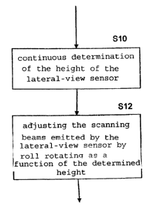
Figure 4 now illustrates a flow chart of an
algorithm which can be carried out, for example, by a
control implemented in the SAR satellite 10 and which
makes it possible to optimize the operation of the SAR
satellite 10 with respect to a PRF that is as constant as
possible. In a first step S10 of the algorithm, the
height of the SAR satellite 10 above the surface of the
celestial body 12 to be detected is continuously
determined. In a subsequent Step S12, the scanning beams
emitted by the SAR satellite 10 for scanning the surface
to be detected are then adjusted by roll rotating as a
function of the determined height of the lateral-view
sensor such that a variation of the surface to be
detected is reduced during the orbit of the lateral-view
sensor. This can take place in that, as a function of
the determined height, for a certain angle of view, the
size of a detected slant range interval of a swath is
computed, and the angle of view is changed as a function
of the height such that the slant range interval of a
swath detected by means of the changed angle of view has
a size that approximately corresponds to the size
computed for the determined angle of view.
Figure 5 illustrates a very simplified block diagram
of a system 16 for optimizing the operation of an active
lateral-view sensor, which system 16 may be constructed,
for example, as a module and may be implemented in an SAR
satellite 10. The system 16 has first devices 18 for the
continuous determination of the height of the lateral-
view sensor above the surface to be detected, and second
devices 20 which are constructed for adjusting the
scanning beams emitted by the lateral-view sensor for
scanning the surface to be detected by roll rotating as a
function of the determined height of the lateral-view
11
CA 02666891 2009-05-27
sensor such that a variation of the surface to be
detected is reduced during the orbit of the lateral-view
sensor. The devices 18 and 20 may be implemented either
as hardware or software or at least partially as hardware
or software. They may be implemented, for example, by a
processor having a memory in which the algorithm outlined
in Figure 4 is filed in the form of a program that can be
executed by the processor.
Compared with a rigid orientation of an antenna, the
defining of the swaths to be covered by means of a roll
steering rule according to the invention permits
particularly the following:
- Longer sections in the orbit can be operated at a
constant PRF: In the example of Sentinel-1, it is even
constant during the entire orbit for almost all swaths.
Furthermore, the complexity of the control/programming is
reduced.
- It may be sufficient to use one and the same
configuration of the measuring instrument (antenna beam)
per swath during the entire orbit.
12
CA 02666891 2009-05-27
Reference Symbols
Lateral-view sensor
12 Celestial body
14 Slant range interval of a swath
141 Slant range interval of a swath
142 Slant range interval of a swath
16 System for optimizing the operation of an
aCtive
lateral-view sensor
18 First devices of system 16
Second devices of system 16
S10-S12 Process Steps
13