Note: Descriptions are shown in the official language in which they were submitted.
CA 02679910 2014-01-22
AIRCRAFT-CENTERED GROUND MANEUVERING MONITORING
AND ALERTING SYSTEM
BACKGROUND OF THE INVENTION
1. Field of the Invention
[0003] The present invention relates to an improved system for alerting
operators
of aircraft during ground operations that the aircraft is approaching a runway
or other
designated area.
2. The Prior Art
[0004] Within the aviation industry, a serious concern exists regarding the
unauthorized entry of aircraft onto airport runways during taxiing operations,
which
is commonly referred to as a "runway incursion." This concern has recently
been
heightened by a number of recent incidents involving "near-misses" occurring
when
two aircraft have attempted to use the same runway or intersecting runways at
the
same time, resulting in the potential for a disastrous collision. In another
recent
incident, a commercial aircraft crashed during takeoff, due to the fact that
the pilot
had attempted to take off from the wrong runway, which was shorter than the
minimum required takeoff distance for the aircraft.
[0005] Various systems have been used in the past in order to minimize the
potential for runway incursions. A number of "traditional" systems are
described in
U.S. Patent No. 6,606,563, which have primarily relied on the pilot and/or air
traffic
- - - -
CA 02679910 2009-09-23
controller to monitor the position of the aircraft relative to airport runways
during
taxiing operations. These systems have included requiring a pilot to request
permission from an air traffic controller before taxiing across a runway,
relying on air
traffic controllers to visually monitor the movement of aircraft while
taxiing, and
placing signs and markings on the ground to indicate the position of an
aircraft
relative to a given runway. However, such systems are not well suited to
prevent
runway incursions at many of today's larger airports, which include many
runways
and taxiways where dozens of aircraft may be taxiing, taking off or landing at
any
given time. Moreover, such systems are less reliable at night or during low-
visibility
conditions, when the ability of pilots and air traffic controllers to monitor
conditions
visually is diminished.
[0006] U.S. Patent No. 6,606,563 discloses a system for alerting an
operator of
a vehicle, such as an aircraft, that the vehicle is approaching or within a
zone of
awareness, such as a runway. The system includes an electronic database which
stores the location of the zone of awareness, a positioning system (e.g., GPS)
which
determines the location of the aircraft, a processor which calculates the
distance
between the vehicle location and the zone of awareness, and an alarm that
alerts
the pilot when the distance is less than a predetermined value. All of these
components are located on the aircraft itself, so that the system need not
rely on
input from outside sources, for example air traffic control systems, in order
to warn
the pilot of a potential runway incursion.
[0007] The storage device of this system comprises a conventional computer
memory device (e.g., RAM, CD-ROM, EPROM), in which is stored a database
including location information for any desired number of zones of awareness.
The
zones of awareness may include all or part of a runway, and may additionally
include
any other area for which an alert would be desirable if approached by an
aircraft
(e.g., construction zone). The coordinates for each zone of awareness may be
determined relative to the surface of the earth, e.g., longitude and latitude.
[0008] The alarm function is disclosed as including either audible and/or
visual
components. The audible alarm may include a synthesized voice warning
identifying
the name of the runway (e.g., "ENTERING RUNWAY 27") and/or the location of the
2
, -
CA 02679910 2009-09-23
aircraft relative to the runway (e.g., "RUNWAY AHEAD"). The visual component
of
the alarm may include a designation of a feature within the zone of awareness,
such
as the word "RUNWAY displayed on a screen, an identification of a specific
runway
(e.g., "RUNWAY 27") on a screen, and/or other information such as a map of the
airport showing the location of various geographical features.
[0009] While the alerting system disclosed by U.S. Patent No. 6,606,563
provides pilots with some notification of potential runway incursions, as
described
above, that system does not teach the use of a conventional electronic airport
chart
to display a graphical depiction of the present position of an aircraft,
relative to the
runway of interest and other geographical features of the airport. Thus, while
the
pilot may understand that he is approaching a runway, he may not immediately
realize where the runway is located relative to his aircraft or which way he
should
proceed to avoid entering the runway-particularly if he is operating at an
airport with
which he is unfamiliar. Moreover, if the pilot has entered a runway different
from the
runway on which the aircraft has been cleared to take off, he may not be
cognizant
of that fact based solely on an audible warning or a visual designation such
as
"RUNWAY appearing on a display screen. Accordingly, it would be desirable to
combine a warning that the aircraft is approaching a runway, with a visual
notification
to the pilot identifying precisely where the aircraft is located relative to
various
geographical features within the airport, at the time of the notification.
[0010] Systems for displaying the position of an aircraft on a display
device
relative to geographical features at an airport, such as runways, taxiways,
terminals,
etc., are known in the art. Electronic airport charts, such as those provided
by
Jeppesen Sanderson, Inc. ("Jeppesen") in association with its JeppView
software,
are routinely utilized by pilots to obtain a graphical depiction of the
position of an
aircraft relative to other geographical features of an airport.
[0011] Electronic airport charts are typically stored in a computerized
database,
which is either located on a hard disk drive or a CD-ROM drive connected to an
onboard computer system. One such system is the Application Server Unit (ASU)
offered by Universal Avionics Systems Corporation ("Universal Avionics). The
computer system typically includes a display unit on which the airport charts
are
3
-
CA 02679910 2009-09-23
displayed, which may comprise either a panel-mounted display unit, such the
EFI-
890R diagonal flat screen display unit from Universal Avionics, or a portable,
standalone display unit, such as the Universal Cockpit Display Terminal (UCDT)
from Universal Avionics. Typically, such systems are able to utilize avionics
data
obtained from the aircraft's flight management system (FMS), including
position,
heading, track and velocity data, to provide a graphical depiction of the
aircraft's
present position and heading on the airport chart display.
[0012] Alternatively, the database may comprise part of a portable,
standalone
computer system, such as an electronic flight bag (EFB) system, which may or
may
not be integrated with the aircraft's avionics systems. One such EFB system is
the
Universal Cockpit Display (UCD) system, from Universal Avionics, which
comprises
a Universal Cockpit Display Computer and one or more UCDT display units. Such
a
system can provide the flight crew with a variety of information such as
checklists,
airport and aeronautical charts, external video displays, electronic documents
and
weather data. However, EFB systems, and particularly those systems which are
not
capable of receiving data from the aircraft's avionics systems, have limited
capability
of notifying the flight crew of potential runway incursions, as they typically
have
limited or no capability of obtaining data regarding the aircraft's position
and velocity,
for display on an airport charts stored within the database.
[0013] Standard airport charts, while useful for providing general position
information, were previously limited by the fact that positional coordinates
on the
charts were not indexed to a fixed global reference frame, such as the WGS 84,
which is the reference system used by the Global Positioning System (GPS). As
a
result, such charts were likely to generate significant error between the
actual
position of the aircraft relative to airport geographical features, as
determined by
GPS, and the aircraft position displayed on the airport chart, because the
positional
coordinates on those charts were not based on WGS 84. The difference between
the true position of the aircraft and the position displayed on a standard
electronic
airport chart could potentially total tens or hundreds of meters. Thus, such
charts
were simply not capable of displaying the position of an aircraft with
sufficient
accuracy tb identify potential runway incursions.
4
CA 02679910 2009-09-23
[0014] In recent years, providers of airport charts, such as Jeppesen, have
solved this problem by providing "geo-referenced" airport charts, in which
each
coordinate on the chart is indexed to a particular geographical location
having a
specific latitude and longitude, as determined relative to a fixed global
reference
frame such as the WGS 84. As a result, a position of an aircraft determined
using
GPS can be displayed on a geo-referenced airport chart with an accuracy
unobtainable using standard, non-geo-referenced airport charts.
[0015] However, in order to realize the significant advantages afforded by
the
use of geo-referenced airport charts, it is important that the system include
some
method for monitoring and identifying inconsistencies between the source data
(which includes both the stored airport geographical feature data as well as
dynamic
aircraft position and orientation data) and the graphical presentation of that
data on
the aircraft display device. Without providing such a monitoring feature in
association with the use of geo-referenced airport charts, the runway,
taxiway,
aircraft position or other airport element could be incorrectly drawn on the
display,
without the pilot being aware of such an error. This could result in either a
false
notifications of a potential runway incursion, or a failure to notify the
pilot of an actual
potential runway incursion.
[0016] Another system for alerting pilots of potential runway incursions is
the
surface area movement management (SAMM) software system provided by Aviation
Communication & Surveillance Systems (ACSS). The SAMM system provides pilots
with warnings of potential runway incursions, by monitoring position signals
received
from other aircraft engaging in taxiing, takeoff or landing operations at the
same
airport, such as ADS-B transmissions and mode-S transponders. Based on such
information, the SAMM system can provide pilots with a warning if another
aircraft
enters the same runway during a takeoff operation. For example, is an airplane
equipped with SAMM were to start its takeoff roll just as another aircraft
equipped
with ADS-B or a mode-S transponder taxied onto the active runway, the cockpit
display in the SAMM-equipped aircraft would immediately draw a red box around
the
active runway, highlight the threat aircraft in red, and provide an aural
alert.
-
CA 02679910 2009-09-23
[0017] However, while the SAMM system is capable of warning a pilot of
potential incursions by other aircraft onto a runway being used by his
aircraft, and
highlighting the position of both aircraft on an electronic airport chart, it
does not
provide the pilot with any notification prior to his own aircraft entering
onto the
runway in the first place. Thus, a pilot who has entered the wrong runway
prior to
takeoff would not be provided with a notification of which runway the aircraft
has
entered, prior to his attempting to take off.
[0018] While systems such as those disclosed above are capable of alerting
pilots to potential runway incursions under certain circumstances, they each
have
significant limitations. Thus, it would desirable to provide a system for
notifying a
pilot that his aircraft is approaching a runway or other geographical feature
of
interest, while simultaneously identifying the position of the aircraft
relative to a geo-
referenced airport chart. This would ensure that the pilot was not only made
aware
that his aircraft would enter a runway if it continues on its current path,
but also
enable the pilot to immediately assess the location of his aircraft relative
to other
airport features. This would likewise minimize the possibility of a pilot
attempting to
take off from the wrong runway, by enabling the pilot to visually confirm from
the
airport chart display that the aircraft is indeed on the correct runway-
particularly at
night or during periods of low visibility when runway markings, lights, etc.,
may be
insufficient for that purpose.
[0019] It would likewise be desirable to provide a method of notifying a
pilot that
his aircraft is approaching a runway or other feature of interest, in which
the
notification includes both a visual notification associated with a geo-
referenced
airport chart, and an audible notification identifying the runway or feature
of interest.
Still further, it would be desirable to provide a method of basing the timing
of the
notifications to the speed of the aircraft. This would ensure that regardless
of aircraft
speed, the aircraft operator always has sufficient time and distance to
respond to an
alert.
[0020] It would further be desirable to provide such a method which further
includes monitoring and notifying the pilot of any errors or inconsistencies
between
6
CA 02679910 2015-02-19
source data (either stored airport data or dynamic aircraft position
orientation data)
and the graphical presentation of that data on an aircraft display device.
SUMMARY OF THE INVENTION
[0020A] According to a first broad aspect of the present invention, there
is
provided a monitoring system for notifying an operator that an aircraft is
approaching
a geographical feature of interest; the system comprising: a database
containing
geo-referenced charts, wherein each geo-referenced chart contains information
related to at least one geographical feature of interest; a processor; a
positioning
system configured to identify at least one of the position, heading, track,
altitude, and
velocity of the aircraft; and a display unit configured to display the geo-
referenced
airport chart and at least one of the present position of the aircraft and the
at least
one geographical feature of interest on the chart; wherein the processor
utilizes the
at least one of aircraft position, heading, track, altitude, and velocity data
from the
positioning system to define a containment area always encompassing at least
the
aircraft and an area surrounding the aircraft, determines whether the at least
one
geographical feature of interest is at least partially located within the
containment
area, and provides a notification signal upon determining that the at least
one
geographical feature of interest is at least partially located within the
containment
area; wherein the notification signal is transmitted to the display unit
causing a visual
notification to be presented to the operator, and wherein the visual
notification
ceases upon the aircraft moving parallel to the geographical feature of
interest for at
least one of a predetermined distance and a predetermined time.
[0020B] According to a second broad aspect of the present invention, there
is
provided a monitoring system for notifying an operator that an aircraft is
approaching a
geographical area of interest, the system comprising: a database including geo-
referenced airport chart data, wherein the airport chart data includes
information on
runways from a plurality of airports; a processor; a positioning system
configured to
identify the position-and velocity of the aircraft; and wherein the processor
defines a
containment area that always encompasses the aircraft wherein the size of the
containment area is a function of the velocity of the aircraft, determines
whether a
7
CA 02679910 2015-02-19
runway is at least partially located within the containment area, and
initiates an
operator notification signal upon determining that the runway is at least
partially
located within the containment area, and wherein the processor further
determines
whether the distance from the aircraft to the runway is decreasing.
[0020C] According to a third broad aspect of the present invention, there
is
provided a monitoring system for notifying an operator that an aircraft is
approaching
a geographical area of interest, the system comprising: a database including
geo-
referenced airport chart data, wherein the airport chart data includes
information on
runways from a plurality of airports; a processor; a positioning system
configured to
identify the position and velocity of the aircraft; and wherein the processor
defines a
containment area that always encompasses the aircraft wherein the size of the
containment area is a function of the velocity of the aircraft, determines
whether the a
runway is at least partially located within the containment area, and
initiates an
operator notification signal upon determining that the runway is at least
partially
located within the containment area, and wherein operator selected departure
runway
information is received by the processor; and further comprising a display
unit, that
displays the selected departure runway.
[0020D] According to a fourth broad aspect of the present invention, there
is
provided a monitoring system for notifying an operator that an aircraft is
approaching
a geographical area of interest, the system comprising: a database including
geo-
referenced airport chart data, wherein the airport chart data includes
information on
runways from a plurality of airports; a processor; a positioning system
configured to
identify the position and velocity of the aircraft; and wherein the processor
defines a
containment area that always encompasses the aircraft wherein the size of the
containment area is a function of the velocity of the aircraft, determines
whether the
a runway is at least partially located within the containment area, and
initiates an
operator notification signal upon determining that the runway is at least
partially
located within the containment area, and wherein the processor receives
information
about aircraft parameters including at least one of fuel flow, throttle
settings, engine
power settings, and engine RPM.
7a
CA 02679910 2015-02-19
[0020E] According to a fifth broad aspect of the present invention, there
is
provided a method for notifying an operator that an aircraft is approaching a
geographical feature of interest, the method comprising: retrieving a geo-
referenced
chart and containment area data from a database; displaying the geo-referenced
chart on a display unit; determining at least one of position, heading, track,
and
velocity of the aircraft; transmitting data corresponding to at least one of
the position,
heading, track, and velocity of the aircraft to a processor; displaying visual
indicia
corresponding to least one of the position, heading, track, and velocity of
the aircraft
on the geo-referenced chart; defining a containment area that has a fixed
positional
relationship to the aircraft; determining whether a geographical feature of
interest is
at least partially located within the containment area; and upon determining
that a
geographical feature of interest is at least partially located within the
containment
area, providing a visible notification to the operator.
[0020F] According to a sixth broad aspect of the present invention, there
is
provided an article of manufacture comprising a programmable processor, a
memory
device, a database encoded in said memory device and comprising geo-referenced
charts, a positioning system configured to identify at least one of a
position, heading,
track, altitude, and velocity of an aircraft, and a display unit, the
processor being
programmed to effect: retrieving a geo-referenced chart and containment area
data
from said database; displaying said geo-referenced chart on said display unit;
determining by said positioning system said at least one of said position,
heading,
track, and velocity of said aircraft; providing data corresponding to said at
least one
of the position, heading, track, and velocity of said aircraft to said
processor;
displaying on said display unit visual indicia corresponding to said least one
of said
position, heading, track, and velocity of said aircraft on the geo-referenced
chart;
defining a containment area that has a fixed positional relationship to the
aircraft;
determining whether a geographical feature of interest is at least partially
located
within the containment area; and upon determining that a geographical feature
of
interest is at least partially located within a containment area, providing a
visible
notification to the operator.
7b
CA 02679910 2015-02-19
[0021] One aspect of embodiments of the present invention is a monitoring
system that notifies an operator, such as an airplane or helicopter pilot,
that an
aircraft is approaching a geographical feature of interest, such as a runway,
taxiway,
intersection, helipad or another aircraft. The monitoring system includes a
database
having geo-referenced airport charts for a number of airports and information
on at
least one geographical feature of interest for each airport. The monitoring
system
further includes a processor, a positioning system configured to determine the
position, heading, track and/or velocity of the aircraft and transmit that
data to the
processor, and a display unit configured to display the geo-referenced airport
chart,
the present position of the aircraft and at least one geographical feature of
interest
on the geo-referenced airport chart.
[0022] After receiving the aircraft position, heading, track and/or
velocity
information from the positioning system, the processor defines a containment
area
including the aircraft and a surrounding area. In one illustrative embodiment
the
containment area is generally circular in shape and centered about the
aircraft. In
another possible embodiment, the containment area is segmented into an inner
containment area and an outer containment area. The processor determines
whether a geographical feature of interest is at least partially located
within the
containment area associated with the aircraft. This could occur, for example,
if an
aircraft is taxing towards a runway. At some point, the containment area
encompassing the aircraft will also include at least a portion of the runway.
In other
words, the containment area will overlap with at least a portion of the
runway.
[0023] After determining that the geographical feature of interest is at
least
partially located within the containment area, the processor initiates a
notification
procedure and transmits a notification signal to the display unit and/or to an
audible
annunciator, e.g., a speaker. If the signal is transmitted to the display
unit, a visible
notification is displayed on the display unit. The visible notification may
include a
change in display of the geographical feature on the airport chart. In
alternative
embodiments, the notification may include a textual or vocal identification of
the
relevant geographical feature.
7c
CA 02679910 2015-02-19
[0024] Alternatively, the geographical feature may be highlighted and/or
flashed on the display unit. The notification ceases after the aircraft moves
away
from the geographical feature such that the feature is no longer at least
partially
located within the containment area. The notification also ceases if the
aircraft is
traveling parallel to the geographic feature for a predetermined distance or
time.
The monitoring system may further include a user input to disable the
notification.
After disabling the notification and after the geographic feature is no longer
at least
partially located within the containment area, the processor may reset such
that a
new notification signal is transmitted if the same or different geographical
feature
becomes at least partially located within the containment area.
[0025] Another aspect of embodiments of the present invention is a
monitoring system that notifies an operator such as an airplane pilot that an
aircraft
is approaching a geographical area of interest. The monitoring system of this
embodiment comprises a database including geo-referenced airport charts, a
processor, a positioning system configured to determine the position, heading
and/or
velocity of the aircraft, and transmit that data to the processor, and a
display unit
configured to display a geo-referenced chart and the present position of the
aircraft
relative to the geo-referenced chart. The monitoring system is further
connected to a
flight management system in which the intended departure runway may be
selected.
[0026] The processor receives the position, heading and/or velocity data
from
the positioning system, defines a containment area about the aircraft, and
then
determines whether a geographical area of interest is at least partially
located within
the containment area associated with the aircraft. Upon determining that a
geographical area of interest is at least partially located within the
containment area,
the processor initiates and transmits a notification signal to the display
unit, causing
a visible notification to be displayed on the display unit. The visible
notification may
comprise a change in display of a geographical feature on the geo-referenced
chart.
The visible notification may also comprise an identification of a geographical
feature
located at least partially within the containment area.
[0027] The processor further receives the intended departure runway
information from the flight management system and causes the display unit to
8
CA 02679910 2015-02-19
. . . .
,
identify the intended departure runway as such. Additionally, the processor
receives
fuel flow information from the flight management system. A notification signal
is
generated and transmitted to the display unit if the measured fuel flow is
greater than
or equal to the amount of fuel necessary for aircraft takeoff and the aircraft
is not on
the intended departure runway.
[0028] Still another aspect of embodiments of the present
invention is a
method of notifying an operator that an aircraft is approaching a geographical
feature
of interest, such as a runway. The method includes retrieving geo-referenced
airport
chart data and containment area data from a database, displaying the geo-
referenced airport chart on a display unit, determining the position, heading,
track
and/or velocity of the aircraft, transmitting data corresponding to the
position,
heading, track and/or velocity of the aircraft to a processor, displaying
visual indicia
corresponding to the position, heading, track and/or velocity of the aircraft
overlaid
on the geo-referenced airport chart, determining whether a geographical
feature is at
least partially located within the containment area, and upon determining that
a
geographical feature of interest is at least partially located within the
containment
area, providing either a visible or audible notification to the operator.
[0029] The visible notification may comprise a change in display
of a
geographical feature on the geo-referenced airport chart. The visible
notification
may also comprise an identification of a geographical feature at least
partially
located within the containment area.
[0030] Various other aspects of embodiments of the present
invention will be
made apparent from the following detailed description of the drawings.
BRIEF DESCRIPTION OF THE DRAWINGS
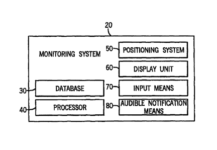
[0031] Fig. 1 is a block diagram illustrating the components of
an illustrative
embodiment of the aircraft ground maneuvering monitoring system of embodiments
of the invention;
9
CA 02679910 2015-02-19
[0032] Fig. 2 is a representation of a conventional airport chart,
indicating the
positioning of runways, taxiways, terminals and other geographical features;
[0033] Fig. 3 is the airport chart of Fig. 2, showing the position of an
aircraft
during a taxiing operation and a containment area according to one aspect of
embodiments of the present invention;
[0034] Fig. 4 is the airport chart of Fig. 3, in which a portion of the
aircraft has
entered the containment area;
[0035] Fig. 5 is a flowchart illustrating features of one method of
monitoring
potential runway incursions with the containment area of Fig. 3 in accordance
with
one aspect of embodiments of the present invention;
[0036] Fig. 6A is the airport chart of Fig. 2, showing the position of
aircraft
during a taxiing operation and a containment area according to another aspect
of
embodiments of the present invention;
[0037] Fig. 6B is the airport chart of Fig. 2, showing one of the
aircraft of Fig.
6A in a different location;
[0038] Fig. 7 is a flowchart illustrating features of a method of
monitoring
potential runway incursions using the containment area of Figs. 6A-6B in
accordance
with another aspect of embodiments of the present invention;
[0039] Fig. 8 is a flowchart illustrating features of a method of
providing
notification if an aircraft is attempting to take off from the wrong runway in
accordance with another aspect of embodiments of the present invention; and
[0040] Fig. 9 is a flowchart illustrating features of a method of
providing
notification of the proper runway to an operator of an aircraft.
DETAILED DESCRIPTION OF THE INVENTION
[0041] While this invention is susceptible of embodiment in many
different
forms, there is shown in the drawings and will herein be described in detail,
several
CA 02679910 2015-02-19
illustrative embodiments, with the understanding that the present disclosure
should
be considered as an exemplification of the principles of the invention and is
not
intended to limit the invention to the embodiments so illustrated.
[0042] While the term "pilot" is used for the sake of simplicity, it
should be
understood that, in the context of the invention, "pilot" refers to any member
of an
aircraft flight crew capable of receiving notifications regarding the state of
the
aircraft. Similarly, the term "operator" refers to any user of a monitoring
system
constructed in accordance with an aspect of the present invention.
[0043] Referring to Fig. 1, one embodiment of an aircraft ground
maneuvering
monitoring system 20 is shown. The monitoring system generally comprises a
database 30, a processor 40, a positioning system 50, a display unit 60, an
input
means 70 and an audible annunciator 80. Some or all components of the
monitoring
system 20 may be included within existing computer systems previously
installed on
an aircraft and integrated with the aircraft's avionics systems, such as the
Application
Server Unit (ASU) from Universal Avionics Systems Corporation ("Universal
Avionics"). Alternatively, the monitoring system 20 may comprise a standalone
unit,
such as an electronic flight bag (EFB) unit, which is fully portable, but is
capable of
obtaining avionics data from the aircraft's flight management system (FMS).
[0044] The database 30 is comprised of a conventional computer data
storage component, such as solid-state random access memory (RAM), CD-ROM,
hard disk drive, or the like. Database 30 is used to store chart data for
electronic
airport charts, such as those provided within Jeppesen's JeppView software
program. A conventional electronic airport chart 100 is shown in Fig. 2, and
includes
at least one runway 121, a taxiway 122, and a terminal 123, among other
geographical features. The electronic airport charts contained within the
database
30 are illustratively geo-referenced, as previously described. Database 30
further
includes data identifying one or more containment areas 124 associated with
each
airport chart 100, which are further described below with reference to Figs. 3
and 4.
11
CA 02679910 2015-02-19
. . .
[0045] Processor 40 comprises a conventional computer processing
component capable of performing mathematical operations and manipulating data,
such as the Pentium series of processors from Intel, Inc.
[0046] Positioning system 50 illustratively comprises a
conventional flight
management system (FMS), which utilizes global positioning system (GPS) and
inertial reference system (IRS) data, to instantaneously determine the
location
(latitude and longitude), heading, track and velocity of the aircraft. Such
flight
management systems are well known in the art. Positioning system 50 may
likewise
comprise any other system(s) known in the art for determining the position,
heading,
track and velocity of an aircraft, and may further utilize an augmentation
system,
such as a wide area augmentation system (WAAS), in order to determine the
position of the aircraft with increased accuracy.
[0047] Display unit 60 illustratively comprises a conventional
computer
display screen, such as a cathode ray tube (CRT) or a liquid crystal display
(LCD).
Examples of display units which are well suited for use in the monitoring
system 20
include panel-mounted display units, such the EFI-890R diagonal flat screen
display
unit from Universal Avionics, and portable, standalone display units, such as
the
UCDT, also from Universal Avionics.
[0048] Input means 70 may comprise any conventional computer input
device, such as a keyboard, mouse, voice recognition unit, touch screen, or
any
combination of the above.
[0049] Audible annunciator 80 may comprise any conventional means
of
providing an audible notification or warning, including a speaker, bell,
buzzer, horn,
or other sound-producing device. The notification provided by the audible
annunciator 80 may take the form of any conventional alarm tone, or
alternatively
may produce a synthesized voice warning. In the latter case, the notification
may
include an identification of a feature located within the containment area
being
approached by the aircraft, for example, "APPROACHING RUNWAY 27".
12
CA 02679910 2015-02-19
[0050] In accordance with one embodiment of the present invention, the
operation of monitoring system 20 is illustrated by reference to Figs. 3, 4
and 5. As
shown in Fig. 5, the monitoring system 20 first retrieves the relevant geo-
referenced
airport chart from the database 30, together with data which identifies the
location of
one or more containment areas 124 on the chart 100. The geo-referenced airport
chart 100 is then displayed on the display unit 60, together with a pictorial
representation of the aircraft 120 identifying the location of the aircraft
120 relative to
other geographical features.
[0051] In Fig. 3, a pictorial representation of aircraft 120 is shown on
the geo-
referenced airport chart 100, as being located on taxiway 122, heading toward
runway 121 (designated on airport chart 100 as Runway 8L). Aircraft 120 is
shown
at a much larger scale than runway 121 and taxiway 122, in order to enhance
the
pilot's ability to ascertain the position of aircraft 120 (which is in reality
smaller than
the width of either) relative to the various geographical features of the
airport, such
as runway 121 and taxiway 122.
[0052] Because the database 30 contains geo-referenced airport chart
data,
both the airport data and the aircraft position data necessarily utilize the
same datum
(e.g., WGS 84). The airport data and aircraft position data are processed by
the
processor 40 to create a geo-referenced graphical presentation of the airport
chart
100. It is illustrative to continually monitor the integrity of the graphical
display, to
ensure that the airport, including runways 121, and aircraft 120 are
accurately
displayed in the correct geo-referenced location and orientation relative to
each
other.
[0053] As shown in Fig. 5, the processor 40 is illustratively programmed
to
monitor and identify any errors or inconsistencies between the source data
(including
airport geographical feature data stored in database 30 and dynamic aircraft
position
and orientation data obtained from positioning system 50) and the graphical
presentation of that data on display unit 60. Before a graphical element
(e.g.,
runway 121 or aircraft 120) is presented on the display screen, the algorithm
verifies
that the element's location and orientation have been computed properly, and
that
the element has been drawn in the proper location and orientation on the
display
13
CA 02679910 2015-02-19
screen relative to other elements. Such a monitoring functionality is provided
in the
aforementioned Universal Cockpit Display and Application Server Unit products
available from Universal Avionics.
[0054] Errors or inconsistencies between the position of the graphical
elements drawn on the display screen and the actual position of those elements
as
identified from the underlying source data can potentially arise due to, for
example,
errors in the underlying source data itself (e.g., the database identifies the
position of
a runway 121 in the wrong location) or incompatibility between the graphics
software
used to draw the elements and the display unit hardware. If processor 40
identifies
any such errors, a notification is preferably provided to the pilot.
[0055] For example, if the airport chart data cannot be properly computed
by
processor 40, airport chart 100 will not be displayed on display unit 60, and
the
notification may comprise an error message displayed on display unit screen.
If an
error is detected in association with the display of a single graphical
element, such
as the position of the runway 121, the notification may comprise displaying
that
graphical element on display unit 60 in another color (e.g., yellow), to
notify the pilot
that the position of the potential error between the displayed position of the
aircraft
120 and that of the displayed graphical element.
[0056] Also shown in Fig. 3 is a containment area 124, which may also be
displayed on airport chart 100, if desired, although the invention does not
require
that a pictorial representation of the containment area 124 itself be
displayed.
Containment area 124 may comprise a fixed area surrounding a runway 121 or
other
desired geographical feature, and is bounded by a boundary 125. In the example
shown, containment area 124 comprises a rectangular area which extends a
specified distance (e.g., 100 meters) beyond the end and side boundaries of
the
runway 121. Alternatively, the containment area 124 may comprise any other
desired fixed area(s). For instance, smaller, individual containment areas 124
may
be located at each intersection between a runway 121 and a taxiway 122, or a
containment area 124 may extend along portions or the entirety of both a
runway
121 and a taxiway 122.
14
CA 02679910 2015-02-19
[0057] Of course, each containment area 124 is not to be limited to a
rectangular configuration, and may take any desired size or shape, depending
on the
specific geographical feature for which a notification is desired, such as a
construction area or military area, to name but a few.
[0058] Alternatively, the configuration of the containment area 124 may
vary
depending on various aircraft operational information such as the
instantaneous
velocity of the aircraft 120. This would enable the monitoring system 20 to
provide a
notification of a potential runway incursion at least a certain amount of time
before
aircraft 120 would reach runway 121 at its present velocity. In such a system,
the
size of the containment area 124 increases or decreases as the velocity of the
aircraft 120 increases or decreases, respectively, to assure that the
notification is
provided to the pilot with sufficient time to change course or stop the
aircraft 120 to
avoid a runway incursion, if necessary. One such configuration may comprise a
rectangular area which extends beyond the boundaries of runway 121 by a
distance
equal to v * t, where v is the instantaneous velocity of aircraft 120 and t is
the desired
period of time which aircraft 120 would require to reach the entrance to
runway 121
at that velocity. For example, if the desired period of time is 15 seconds and
aircraft
120 is taxiing at a speed of 15 knots (15 m/s), processor 40 would calculate
the
containment area 124 at that instant as extending 450 meters beyond the
boundaries of the runway 121. As the processor 40 continuously receives
instantaneous velocity data from the positioning system 50, the size of
containment
area 124 increases or decreases, as the velocity of aircraft 120 increases or
decreases.
[0059] In yet another alternative embodiment, containment area 124 may
vary according to operation information such as the velocity of the aircraft
120, as
described above, relative to a second, smaller area which extends beyond the
boundaries of the runway 121 itself. This embodiment would be intended to
ensure
that, even if the aircraft were traveling very slowly, the pilot would receive
notification
some distance prior to entering the runway. In such an embodiment, at any
given
instant containment area 124 would extend beyond the boundaries of runway 121
by
a distance equal to x + (v *t), where x equals the minimal distance from the
runway
CA 02679910 2015-02-19
at which a notification would be provided. Of course, various modifications to
the
method of determining the size of the containment area may be made to enable
the
determination of a containment area having any desired, non-rectangular shape,
based in whole or in part on the velocity of the aircraft,.
[0060] In another alternative embodiment shown in Figs. 6A-6B, and
described in further detail below, a generally circular containment area 224
is
generated and centered about the aircraft 120. The containment area 224 is not
limited to a circular shape and may be defined by other shapes such as ovals,
rectangles, and the like. Further, the location of the containment area 224 in
relation
to the aircraft 120 may be arranged in alternative manners including, but not
limited
to, centered about the front of the aircraft 120, encompassing only a portion
of the
aircraft 120, such as the wings and an area in front of the aircraft 120, and
the like.
Certain types of vehicles may have containment areas with predetermined sizes
and
geometries. For instance, a helicopter or a land-based vehicle would generally
have, at least initially, a circular containment area as these types of
vehicles may
move in various radial directions. The containment area for an airplane,
although
including at least the entire airplane body, may further require additional
space in
front of the airplane as that is the typical direction of travel.
[0061] Referring again to Figs. 3 and 4, as aircraft 120 approaches
runway
121, positioning system 50 continually monitors the instantaneous position,
heading,
track and/or velocity (horizontal and/or vertical) of aircraft 120, and
communicates
that data to processor 40. Based on the position, heading, track, and/or
velocity
data, processor 40 continuously evaluates whether aircraft 120 has entered
containment area 124. Depending on the desired method of determining the size
of
the containment area (as discussed above), any combination of the position,
heading, track and/or velocity data may be utilized by processor 40 in
determining
whether aircraft 120 has entered a containment area 124. Prior to entry of
aircraft
120 into containment area 124, monitoring system 20 can be thought of as in a
"standby mode", in which monitoring system 20 is continuously monitoring the
position of aircraft 120 relative to containment area 124, but has yet to
generate any
notification to the pilot.
16
CA 02679910 2015-02-19
[0062] When, as shown in Fig. 4, aircraft 120 has reached boundary 125 of
containment area 124, processor 40 initiates a notification signal to display
unit 60,
to provide a visible notification to the pilot that aircraft 120 has entered
containment
area 124. At this point, monitoring system 20 has entered an "alert mode", in
which
monitoring system 20 continues to provide a visible notification to display
unit 60,
until aircraft 120 either exits containment area 124, thereby returning the
system to
standby mode, or the pilot disables the visible notification as further
described below.
[0063] The visible notification may consist of a change in the way runway
121
is displayed on geo-referenced airport chart 100, such as changing the color
of
runway 121 to a color which differs from other features shown on airport chart
100
(e.g., from black to red), causing runway 121 to flash, or a combination of
the two.
Alternatively, or in addition to the change in the display of runway 121, the
visible
notification may include other changes to the display of airport chart 100,
such as
changing the color of the chart background, causing a textual warning 130
identifying
the geographic feature associated with the specific containment area 124
(e.g.,
"APPROACHING RUNWAY 8L") to appear and/or flash on a certain portion of
display unit 60, changing the color of aircraft 120, causing aircraft 120 to
flash, or a
combination of any or all of the above.
[0064] In addition to generating a visible notification, upon entering
"alert
mode," monitoring system 20 may also initiate a notification signal to audible
annunciator 80 to generate an audible notification to the pilot, as described
above.
[0065] After monitoring system 20 has entered the "alert mode", the pilot
of
aircraft 120 may be permitted to disable either or both of the visible and/or
audible
notifications, by way of input means 70. Such a feature is particularly
illustrative
where monitoring system 20 includes a repeated or continuous audible
notification,
which is no longer necessary once the pilot has been notified that aircraft
120 is
approaching runway 121. Where input means 70 comprises a touch screen, such as
with the Universal Avionics UCDT, there may be provided a location on the
touch
screen which disables the visible and/or audible notifications when touched.
Alternatively, where input means 70 comprises a keyboard, any desired
keystroke
(e.g., space bar, ESC key, etc.) or combination of keystrokes may disable the
visible
17
CA 02679910 2015-02-19
and/or audible notifications. This feature may be configured so that the pilot
may
disable the audible notification, but not the visible notification, or vice
versa.
[0066] Illustratively, when a pilot disables the visible and/or audible
notifications, those notifications are disabled only with respect to the
containment
area 124 in which the aircraft 120 is presently located. In that case,
monitoring
system 20 will return to "standby mode" upon disabling of the visible and/or
audible
notifications by the pilot, and will once again provide a notification if
aircraft 120
leaves and reenters containment area 10 124, or enters a different containment
area
124 identified in database 30. Likewise, processor 40 will be programmed so
that
monitoring system 20 will return to "standby mode" once aircraft 120 exits
containment area 124, and will once again provide a notification if aircraft
120
reenters containment area 124 or enters a different containment area 124.
[0067] Referring now to Figs. 1, 6A, 6B, and 7, an alternative aircraft
ground
maneuvering monitoring system and method is disclosed. The following
description
should also be viewed in light of the discussion regarding the method of Fig.
5,
including certain aspects such as retrieving the relevant geo-referenced
airport chart
data and monitoring for inconsistencies between the source data and the
graphical
presentation of that data that have already been fully discussed.
[0068] As shown in Figs. 6A-6B, the present position of the aircraft 120 is
displayed
on the airport chart 100 relative to a number of geographical items of
interest.
Geographical items of interest include an intended departure runway 121, a
taxiway
122, other runways 126, 127, a runway intersection 128, a helipad (not shown),
and
the like. The processor 40 obtains information regarding the airport chart 100
and
geographical items of interest specific to the airport chart 100 from the
database 30
as previously discussed. The processor 40 further obtains information
regarding the
present position, speed, track and/or heading of the aircraft 120 from the
positioning
system 50. The positioning system 50 may provide further information to the
processor 40 such as the operator-selected departure runway 121 and real time
aircraft parameters including fuel flow, throttle settings, and the like.
18
CA 02679910 2015-02-19
[0069] Based on information received from the positioning system 50, the
processor 40 defines a containment area 224 that encompasses the aircraft 120
and
an area surrounding the aircraft 120. According to the embodiment shown,
containment area 224 is comprised of an inner containment area 225 defined by
a
first boundary 226 and an outer containment area 227, defined by a second
boundary 228. Multiple containment areas with different sizes or shapes
provides
for the ability to attribute different types of notifications to different
types of incursions
into the containment areas.
[0070] According to the embodiment shown, the containment area 224 is
centered about the aircraft 120, extends radially outward therefrom, and moves
in
unison with the aircraft 120. The size and shape of the containment area 224
may
be a function of the aircraft speed or time/distance required to stop the
aircraft 120.
In other words, the containment area 224 may expand when the speed increases
and contract accordingly when the speed decreases. The inner and outer
containment areas 225, 227 may expand and contract uniformly (such as by a
linear
rate), with variable rates, or while maintaining a constant distance between
the
boundaries 226, 228. The exact configuration necessarily depends on the design
parameters required for each application.
[0071] Other relevant factors used by the processor 40 in determining the
size and shape of the containment area 224 may include whether pre-defined
runway incursion risk areas are present, the type of geographical features
present,
etc. For example, if one of the geographical features is another aircraft 131,
the
processor 40 may use that aircraft's speed and other parameters obtained via
the
ADS-B or TCAS systems to modify the containment area 224 accordingly. If the
other aircraft 131 is moving towards the aircraft 120, the processor 40 may
increase
the size of the containment area 224 to give the pilot of the first aircraft
120 more
time to react because the other aircraft 131 may not utilize a ground
maneuvering
system. On the other hand, if the other aircraft 131 is stopped or moving away
from
the first aircraft 120, no modification to the containment area 224 would be
needed.
19
- _ -
CA 02679910 2009-09-23
[0072] In one embodiment, if the aircraft 120 is moving towards a
geographical
feature of interest, e.g., runway 121, (as determined by the fact that the
distance
between the runway 121 and aircraft 120 is decreasing) and the runway or other
geographical feature of interest becomes at least partially located within the
containment area 224, a notification signal routine is initiated by the
processor 40.
As shown in Fig. 7, a notification signal is transmitted to both the display
unit 60 (i.e.,
a display screen on an ASU unit) and the aircraft's flight management system
(FMS)
unit. Alternatively, the display unit 60 and FMS unit may regularly poll the
processor
40 for notification information and react accordingly. Regardless, some form
of
notification that a potential runway incursion situation exists (shown in Fig.
6 where
at least a portion of the runway 121 is located within the containment area
224) is
made to the operator so that the appropriate action may be taken.
[0073] In one contemplated visual notification provided by the display unit
60,
the runway '121 is highlighted and flashed repeatedly. A message such as
"RNVVY
ALERT" or the like is also displayed on the FMS. An audible notification may
also be
provided to the operator. As previously described, the operator may
acknowledge or
disable the notifications even if a portion of the runway 121 is still located
within the
containment area 224. For example, if the pilot intends to take off from
runway 121
and the aircraft 120 is located on that runway, there is no need to continue
displaying this notification to the pilot. Once acknowledged or disabled, the
processor 40 causes the notifications to cease. The runway 121 shown on
display
unit 60 is no longer displayed with highlighting or flashing. Alternatively,
if the
aircraft 120 is moving away from the runway 121 (as shown in Fig. 6B) or
parallel to
it, for example, if traveling on a taxiway 129 running parallel to the runway
121, the
processor 40 may also cause the notifications to cease. After the notification
has
been acknowledged or disabled, either by the operator or the processor 40, the
monitoring system 20 again operates in a stand-by mode and continues
monitoring
the containment area 224. Thereafter, if a geographical feature of interest,
even the
same runway 121, becomes at least partially located within the containment
area
224, a new notification is provided to the operator.
_
CA 02679910 2009-09-23
[0074] Referring now to Figs. 1, 6A, 6B, and 8, an alternative method of
operating an aircraft ground maneuvering monitoring system is disclosed. In
this
embodiment, the monitoring system 20 tracks, via the positioning system 50,
and
displays, via the display unit 60, the position of the aircraft 120 relative
to the airport
chart 100. The positioning system 50 may comprise or be connected to an FMS
unit
with which an operator selects an intended departure runway 121. The processor
40
obtains this runway information and provides a visual notification, via
display unit 60,
of the intended departure runway 121. The runway 121 may be displayed in a
certain color, e.g., green, or may be indicated in other, readily
ascertainable ways.
[0075] According to one aspect of this embodiment, processor 40 also
receives
real-time aircraft parameters including information related to take-off such
as fuel
flow and throttle settings for the aircraft 120. If the aircraft is on a
runway, e.g.,
runway 127, that is not the intended departure runway, e.g., runway 121, and
one or
more of the aircraft parameters indicate that the aircraft 120 is in takeoff
mode (e.g.,
a fuel flow greater than or equal to the amount of fuel required for achieving
takeoff
speeds or other engine performance parameters), a warning message is generated
and presented to the operator. In this scenario, for example, the incorrect
runway
127 would be highlighted, displayed in red, and flashed in an attempt to warn
the
pilot. The flight management system unit may also display an appropriate
warning
message or other type of notification.
[0076] In another aspect of this embodiment, shown in Fig. 9, the selected
departure runway 121 is highlighted and displayed in green on the display unit
60. If
the aircraft 120 is moving towards the departure runway 121, i.e., the
distance
between the aircraft 120 and runway 121 is decreasing, and a portion of the
runway
121 is located within the outer containment area 227, the runway 121 is
flashed to
indicate that the aircraft 120 is near the selected departure runway 121.
[0077] While the embodiments of the invention described herein relate to a
system for alerting a pilot to potential runway incursions while engaged in
taxiing
operations at an airport, the principles of the invention are equally
applicable to in-
flight operations as well, using geo-referenced approach and/or enroute charts
such
as those provided by Jeppesen. For example, the geographical feature for which
an
21
CA 02679910 2009-09-23
approach notification is desired could comprise an area of restricted
airspace, and a
notification could be provided to a pilot when the aircraft enters a
containment area
corresponding either to a fixed distance surrounding that airspace, a variable
distance based on the amount of time which the aircraft would require to reach
that
airspace, or some combination thereof.
[0078] Additionally, while the embodiments of the invention describe herein
relate to a monitoring system utilized in connection with an aircraft in the
environment of an airport, it is to be understood that the principles of the
invention
could readily be applied to other vehicles and/or other environments where it
would
be desirable to provide a notification to the operator of a vehicle that the
vehicle is
approaching a particular geographical feature or area. The principles of the
invention would function equally well in such other environments, provided
that the
system includes a database having a geo-referenced chart showing the
environment
in which the vehicle is operating and the specific geographical features or
areas of
interest, and a display unit capable of displaying the geo-referenced chart
and the
position of the vehicle thereon.
[0079] The foregoing description and drawings merely explain and illustrate
the
invention, and the invention is not so limited as those skilled in the art who
have the
disclosure before them will be able to make modifications and variations
therein
without departing from the scope of the invention.
22