Note: Descriptions are shown in the official language in which they were submitted.
CA 02683359 2009-10-21
GYR0.021VCA PATENT
DONI'NIIOLE SURVEYInG UTTLIZlNG MULTIPLE MEASURE119]'sNTS
CROSS-REFERENCE TO RELATEI? APPLICATIONS
100011 This application is a continuation-in-part of U.S. Patent Application
Serial
No. 12/256,410, filed on October 22, 2008, entitled "Downhole Surveying
Utilizing Multiple
Measurements,the entire contents of which is hereby incorporated by reference.
BACKGROUND
Field of tlie Invention
10002J The present application relates generally to svstems and methods for
utilizing measurements from multiple sensors on a drilling tool within a
wellbore to correct
for measurement errors, detennine the curvature of a wellbore, and/or
deterinine The position
of the wellhore in relation to another wellbore.
Description of the Related Art
100031 Rotary steerable drilling tools can be equippeci with survey
instrumentation, such as measurcnient while drilling (MWD) instrumentation,
which
provides information regarding ihe orientation of The survey tool, and hence.
the orientation.
of the wcll a1 the tool location. Survey instrumentation can make use of
various ineasured
quantities such as one or more oi' acceleration. mal;netic field, and angular
rate to determine
the orientation of the tool and the associated weilbore with respect to a
reference vector such
as the Earih's gravitational held; magnetic field; or rotation vector. 'rhe
rletenziination of such
directional information at Generally regular intervals aiong The path of the
well can be
combined wilh ineusurcments of ivcll depth to allo~\, the trajectory of the
well to be
detennined. flowever, measurements used in this process can he suhject to
errors. For
example. Ihe errors may be the reSull of imperfections intenial to the
instrumentation itself or
external disturbances that can affect the output of the instrumentation and
its associated
sensors. Internal errors can generally be accounted for using calibration
teehniques and other
methods. However, external errors. such as crrors resulting 1ronl
misalignments of the
sensors within ihe welJbore, or errors caused by dis(urbances affecting the
relevant reference
vector {e.g.. the Larth's magnctic field) can be more difficult to correct.
-1-
CA 02683359 2009-10-21
100041 In addition, when a wellbore is drilled in an area in which one or more
existing wellbores are present it is useful to deterrnine the relative
position of the wellbore
and downhole portion of the dri]ling tool in relation to the existing
wellbore. For exaniple,
this information can be useful to avoid collisions with existing wellbores or
to drill a rclief
well to intercept an existing well. Furthermore, there are situations in which
it is usefUl to
drill a well alongside an existing well to implement a process knowri as steam
assisted gravity
drainage (SAGD) to facilitate the retrieval of heavy oil deposits in certain
parts of the world.
In this case, existing methods involve inserting equipment, such as a
solenoid, into the
existing wellbores. 'i'he equipment gives rise to magnetic field disturbances,
which can be
detected by sensors in #he new well and used to determine the position of the
drilling tool and
wellbore in relation to the existing wellbore. Such techniques can be costly,
in part because of
the additional equipment involved and because such operations are time
consuming.
SUMMARY
[0005] According to certain embodiments, a method of generating inforrnation
indicative of an orientation of a drill string relative to the Earth while in
a wellbore is
provided. The inethod includes receiving one or more first signals from a
first sensor package
mounted in a first portion of the di=ill string at a first position wilhin a
welibore, the first
signals indicative of an orientation of the first portion of the drill string
relative to the Earth.
The method further includes receiving one or more second signals from a second
sensor
package mounted in a second portion of the drill string at a second position
within the
wellbore, the second signals indicative of an orientation of the second
portion of the drill
string relative to the Earth. The method according to certain embodiments also
includes
calculating a differeice between the orientation of the first portion and the
second portion in
response to the first signals and the second signals.
100061 A drill string is provided in certain embodiments, comprising a
downhole
portion adapted to move within a wellbore. The downhole portion having a first
portion at a
first position within thc wetlbore and a second portion at a second position
within the
wellbore. The drill string further includes a first sensor package mounted
within the first
portion, the first sensor package sensor adapted to generate a first
measurement indicative of
an orientation of the first portion. In certain embodiments, the drill string
also includes a
-2-
CA 02683359 2009-10-21
second sensor package mounted within the second portion, the second sensor
package
adapted to generate a second measurement indicative of an orientation of the
second portion.
The drill string further includes a controller configured to calculate a
difference between the
orientations of the first portion and the second portion in response to the
first measurement
and the second measurement.
100071 In certain embodiments, a method of controlling a drill string is
provided.
The method comprises receiving one or more first signals from a first sensor
package
mounted in a first portion of the drill string at a first position with~n a
wellbore. The first
signals may be indicative of an orientation of the first portion of the drill
string relative to the
Earth. The method also includes receiving one or more second signals from a
second sensor
package mounted in a second portion of the drill string at a second position
within the
wellbore. In certain embodiments, the second signals indicative of an
orientation of the
second portion of the drill string relative to the Earth. The drill string may
be adapted to bend
between the first portioii and the second portion. The method of certain
embodiments
includes calculating a first amount of bend between the first portion and the
second portion in
response to the first signals and the second signals.
100081 A drill string is provided in certain embodiments comprising a downhole
portion adapted to move within a wellbore. The downhole portion inay have a
first portion at
a first position within the wellbore and a second portion at a second position
within the
wellbore. In certain embodiments, the downhole portion is adapted to bend
between the first
portion and the second portion. The drill string may include a first sensor
package mounted
within the first portion which can be adapted to generate a first measurement
indicative of an
orientation of' the first portion relative to the Earth. 'I'he drill string
may further include a
second sensor package mounted within the second portion which can be adapted
to generate a
second measurement indicative of an orientation of the second portion relative
to the Earth.
The drill string of certain embodiments includes a controller configured to
calculate an
aniount of bend between the first portion and the second portion in response
to the first
measurement and the second measurement.
100091 In certain embodiments, a drill string is provided which includes a
downhole portion adapted to move within a weIlbore, the downho]e portion
having a first
-3-
CA 02683359 2009-10-21
portion at a first position within the wellbore and oriented at a first angle
relative to the
wellbore at the first position and a second portion at a second position
within the wellbore
and oriented at a second angle relative to the wellbore at the second
position, wherein at least
one of the first and second angles is non-zero. The drill string of certain
embodiments
includes a first acceleration sensor mounted within the first portion, the
first acceleration
sensor adapted to generate a first signal indicative of an acceleration of the
first acceleration
scnsor. The drill string of certain embodiments also includes a second
acceleration sensor
mounted within the second portion, the second acceleration sensor adapted to
generate a
second signal indicative of an acceleration of the second acceleration sensor.
[0010) In certain enibodiments, a method for generating information indicative
of
misa]ignment between first and second acceleration sensors mounted within the
downhole
portion of a drill string is provided. The method of certain embodiments
includes providing a
drill string comprising. The drill string of certain embodiments includes a
downhole portion
adapted to move within a wellbore, the downhole portion having a first portion
at a first
position within the wellbore and orriented at a first angle relative to the
wellbore at the first
position and a second portion at a second position within the wellbore and
oriented at a
second angle relative to the wel)bore at the second position wherein at least
one of the first
and second angles is non-zero. The drill string can also include a first
acceleration sensor
mounted within the first portion, the first acceleration sensor adapted to
generate a first signal
indicative of an acceleration of the first acceleration sensor and a second
acceleration sensor
mounted within the second portion, the sccond acceleration sensor adapted to
generate a
second signa] indicative of an acceleration of the second acceleration sensor.
The method of
certain embodiments further includes generating the first signal and the
second signal while
the downhole portion of the drill string is within the wellbore.
[0011] In certain embodiments, a method of determining the misalignment
between first and second acceleration sensors mounted within a drill string is
provided. The
method of certain embodiments includes receiving one or more acceleration
measurements
frorn a first acceleration sensor in a first portion of the drill string at a
first position within a
wellbore, the first portion oriented at a first angle relative the wellbore at
the first position.
The method further includes receiving one or more acceleration measurements
from a second
-4-
CA 02683359 2009-10-21
acceleration sensor in a second portion of the drill string at a second
position within the
wellbore, the second portion oriented at a second angle relative to the
wellbore at the second
position, wherein at least one of the first and second angles is non-zero. The
method further
includes calculating the difference between the first angle and the second
angle in response to
the one or more acceleration measurements from the first acceleration sensor
and the one or
more measurements from the second acceleration sensor.
(0012] In certain embodiments, a drilling systein is provided which includes a
downhole portion adapted to move along a first wellbore, the downhole portion
comprising
one or more magnetic regions and one or more non-magnetic regions. The
drilling system of
certain ernbodiments includes at least two rnagnetic sensors within at least
one non-magnetic
region of the downhole portion, the at least two magnetic sensors comprising a
first magnetic
sensor and a second magnetic sensor spaced apart from one another by a non-
zero distance,
the first magnetic sensor adapted to generate a first signal in response to
magnetic fields of
the Earth and of the one or more magnetic regions, the second magnetic sensor
adapted to
generate a second signal in response to magnetic fields of the Earth and of
the one or more
magnetic regions. The drilling system can include a controller configured to
receive the first
signal and the second signal and to calculate the rnagnetic field of the one
or rnore magnetic
regions.
100131 In certain embodimeiits, a method for generating information indicative
of
the magnetic field in a first wellbore is provided. 'The method includes
providing a drilling
system comprising a downhole portion adapted to move along a first wellbore,
the downhole
portion comprising one or more magnetic regions and one or more non-magnetic
regions. The
drilling system of certain embodiments further includes at least two magnetic
sensors within
at least one non-magnetic region of the downhole poilion, the at least two
magnetic sensors
comprising a first magnetic sensor and a second magnetic sensor spaced apart
fi-om one
another by a non-zero distance, the first magnetic sensor adapted to generate
a first signal in
response to magnetic fields of the Earth and of the orie or more magnetic
regions, the second
magnetic sensor adapted to generate a second signal in response to magnetic
fields of the
Earth and of the one or more magiietic regions. The method further includes
generating the
first signal and the second signal while the downhole portion of the drilling
system is at a first
-5-
CA 02683359 2009-10-21
location within the first wellbore and calculating the magnetic field in the
first wellbore in
response to the first and second signals.
100141 In certain embodiments, a method for determining the magnetic field in
a
wellbore is provided. The method includes receiving one or more magnetic
measurements
from at least two magnetic sensors within at least one non-magnetic region of
a downhole
portion of a drilling system, the at least two magnetic sensors comprising a
first magnetic
sensor and a second magnetic sensor spaced apart from one another by a non-
zero distance,
the first magnetic sensor generating a first signal in response to magnetic
fields of the Earth
and of one or more magnetic regions of the downhole portion, the second
magnetic sensor
generating a second signal in response to magnetic fields of the Earth and of
the one or more
magnetic regions. The method of certain embodiments further includes
calculating the
magnetic field in response to the one or more magnetic measurements from the
at least two
magnetic sensors.
BRIEF DESCRIPTION OF THE DRAWINGS
100151 Figure i schematically illustrates an example drill string for use in a
wellbore and having first and second acceleration sensors that are misaligned
in accordance
with certain embodiments described herein.
100161 Figure 2 schematically illustrates an example drill string for use in a
wellbore and having first and second acceleration sensors that are misaligned
and where the
drill string is in a portion of the wellbore having a curvature in accordance
with certain
embodiments described herein.
{0017) Figure 3 is a flowchart of an example method of generating information
indicative of misalignment between first and second acceleration sensors
mounted in the
downhole portion of a drill string in accordance with certain embodiments
described hcrein.
10018J Figure 4 is a flowchart of an example method of determining the
misalignment between first and second acceleration sensors mounted on the
downhole
portion of a drill string in accordance with certain embodiments described
herein.
100191 Figure 5 schematically illustrates an example drilling system including
a
downhole poi-tion moving along a first wellbore and including at least two
magnetic sensors
in accordance with certain embodiments described herein.
-6-
CA 02683359 2009-10-21
10020) Figure 6 schematically illustrates the example drilling system of
Figure 5
wherein the downhole potlion is moving along a first wellbore and is
positioned relative to a
second wellbore spaced from the first we]lbore in accordance with certain
embodiments
described herein.
[0021] Figure 7 is a flowchart of an example method of generating information
indicative of the magnetic field in a wellbore in accordance with certain
embodiments
described herein.
100221 Figure 8 is a flowchart of an example method of determining the
magnetic
field in a we]lbore in accordance with certain embodiments described herein.
(0023] Figure 9 schematically illustrates an example drill string for use in a
wellbore and having first and second sensor packages in a portion of the
wellbore having a
curvature in accordance with certain embodiments described herein.
10024) Figure ] 0 schematically illustrates an example control loop for
calculating
and adjusting the curvature bctween first and second portions an example drill
string having
first and second sensor packages in a portion of the wellbore having a
curvature in
accordance witli certain embodiments described herein.
10025] Figure 1] is a directiona] diagram illustrating the relative
orientation
between a first position in the wellbore and a second position in the we]lbore
in a portion of
the wellbore having a curvature in accordance with embodiments described
herein.
100261 Figure 12 is a flowchart of aii example niethod of controlling a drill
string
according to a calculated amount of bend in aceordance with certain
embodiments described
herein.
DETAILED DESCRIPTION
100271 Certain embodiments described herein provide a downhole-based system
for utilizing measurements from multiple sensors on a drilling too] within a
wellbore to
correct for measurement errors and so allow the trajectory of the well to be
determined with
greater accuracy than could be achieved using a single set of sensors. The
application of
multiple sensors also facilitates the detetmination of the position of the
wellbore in relation to
another wellbore. In certain embodiments, the system is generally used in
logging and drilling
applications. Additionally, embodiinents described hereiri utilize rrrultiple
sensor
-7-
CA 02683359 2009-10-21
measurements to detect an amount of wel] curvature and adjust the drilling
too] to achieve a
desired curvature.
(0028] In cerlain embodiments described herein, mcasurements from multiple
sensors on a drill string provide improved measurement accuracy. For example,
certain
embodiments described herein correct for extemal sensor errors utilizing
multiple sensors.
Sensors may be included in, for example, a measurement whi]e drilling (MWD)
instrumentation pack. Additional sensors may be located on a rotary steerable
tool in
accordance with certain embodiments described herein, and can provide enhanced
accuracy
of, for example, the rneasuremerit of the direction in which the well is
progressing and can
provide more imrnediate information i-egarding changes in well direction.
Certain
embodiments described herein disclose a drill string including a MWD survey
instrument and
a rotary steerable tool, where both the MWD survey instrument and the rotary
steerable tool
inc]ude acceleration sensors, magnetic field sensors, or both.
100291 A measurement of a quantity (x~4) may be expressed as the sum of the
true
value of that quantity (x) summed with a disturbance error term (s), where the
error may be a
function of the well path, its attitude or its heading at the measureznent
location, and the
position of the sensing means with respect to a source of disturbance (dD).
For example, dD
may be the position of a magnetic field sensor with respect to a local
magnetic disturbance
field that may distort the components of the Earlh's magnetic field which the
magnetic field
sensor is configured to measure.
x~~ x+ci (I,A:dDõ-..}; (Eq. ])
where xMl is magnetic field measured by a first magnetic field sensor, x is
the rnagnetie field
of the Earth at the location of the first magnetic field sensor, and si is the
disturbance error
which. can be a function of tool azimuth angle (A), inclination (1), and the
distance (dD,) of
the magnetic sensor from a local magnetic disturbance field.
100301 A second measurement of the quantity (:c,,j) at another location along
the
tool string may be expressed as:
xn,l2 = x+ s: (1: AJd r~: ~...}. (Eq. 2)
-8-
CA 02683359 2009-10-21
where XM2 is magnetic field measured by a second magnetic field sensor, x is
the magnetic
field of the Earth at the second magnetic field sensor location, and sz is the
disturbance error
which can also be a function of azimuth (A), inclination (1) and the distance
(dn2) of the
magnetic sensor with respect to a local magnetic disturbance field.
100311 Taking the difference between the two measurements yields:
AxM = xu I -xM2 = CjI, A, dD11...)-s2(I, A,dDZ1 ...). (Eq.3)
100321 Thus, where the parameters affecting error terms are known, the
measurements may be generally used to estimate and correct for the error.
Certain
embodiinents described herein make use of measurements fro3n multiple
acceleration
sensors, multiple magnetic field sensors, or both to correct for measurement
en-ors. For
example, acceleration sensors mounted on the downhole portion of a drill
string can be used
to detertnine the inclination of the drill string. According to certain
embodiments described
herein, the use of ineasurcments from multiple acceleration scnsors may be
used to detennine
inclination measurement errors owing to the misalignment of the corresponding
portions of
the drill string in which the sensors are mounted.
10033] In certain embodiments, magnetic sensors included in a drill string can
provide measurements of the orientation of a downhole portion of the drill
string with respect
to the magnetic field of the Earth. However, magnetized portions of the drill
string can
interfere with the orientation measurements causing measureinent errors. ln
certain
embodiments disclosed herein, data from multiple magnetic sensors may be used
to
determine the amount of magnetic interference caused by the magnetized
portions of the drill
string. in certain embodiments, the magnetic sensors may also be used to
determine the
proximity of the drill string or a portion of the drill string to an existing
well.
(0034] The present application relates generally to systems and methods for
ut.ilizing measurements from multiple sensors on a drilling too] within a
wetlbore to correct
for nieasurement errors and/or determine the position of the wellbore in
relation to another
wellbore.
100351 Additionally, certain Embodiments described herein provide two or more
directional survey measurements frotn tnultiple sensors at a known separation
distance(s)
along the tooi string. Additionally, certain embodimcnts described herein
generate a measure
-9-
CA 02683359 2009-10-21
of the curvature of the well between two or more survey system locations by
differencing the
survey system estimates of orientation (e.g., inclination and azirnuth angle)
provided at each
location.
A. Comparison of Multiple Acceleration Measureinents to Determine Sensor
Misali ant
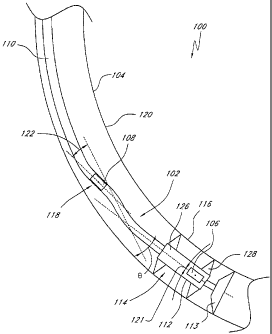
100361 Figure 1 and Figure 2 schematically illustrate an example downhole
portion 102 of a drill string 100 within a wellbore 104 having a first
acceleration sensor 106
and a second acceleration sensor 108 that are misaligned relative to one
another. In Figure 1,
the downhole portion 102 is in a generally straight section of the wellbore
104, and in Figure
2, the downhole portion 102 is in a curved or angled section of the wellboi-e
104. In certain
embodiments, the drill string 100 may include an elongate portion I 10,
comprising sections
of drill pipe and drill collars, and a rotary steerable tool 112. In certain
embodiments, the drill
string comprises a downhole portion 102 adapted to move within the wellbore
I04. In certain
einbodiinents, the downliole portion 102 includes a first portion 114 at a
first position 116
within the wellbore 104. In ceriain embodiments, the first portion 114 of the
downbole
portion 102 is oriented at a first angle 121 relative to the wellbore 104 at
the first position
116. The downhole portion 102 may further comprise a second portion 118 at a
second
position 120 within the wellbore 104 and oriented at a second angle 122
relative to the
wellbore 104 at the second position 120. At least one of the first angle 121
and the second
angle 122 is non-zero.
[00371 The drill string 100 may, in certain embodiments, be a measurement-
while-drilling string. In certain embodiments, the drill string 100 can
include a MWD
instrumentation pack. In certain embodiments, the first acceleration sensor
106 is mounted
within the first portion 114 (e.g., on the rotary steerable too] 112) and is
adapted to generate a
first signal indicativc of the specific forcc acceleration to which the first
acceleration sensor
106 is subjected. In certain embodiments, the second acceleration sensor 108
is mounted
within the second portiori 118 (e.g., on the elongate portion 110 of the drill
string 100) and is
adapted to generate a second signal indicative of the specific force
acceleration sensed by the
second acceleration sensor 108. In certain other embodiments, the first and
second
acceleration sensors 106, 108 may be mounted on the downhole portion 102 in
other
configurations compatible with embodiments described herein. For example, in
some
- f 0-
CA 02683359 2009-10-21
embodiments, both of the first and second acceleration sensors 106, 108 are
mounted on the
elongate portion 1 10 (e.g., in two MWD instrumentation packs spaced apart
from one another
or alongside one another). In other embodiments, both of the first and second
acceleration
sensors 106, 108 are mounted on the rotary steerable tool 112. In certain
embodiments, one or
more additiona] sensors (not shown) are ]ocated near the first sensor 106, the
second sensor
108, or both. For example, in some embodiments, a third sensor is located near
the first
sensor 106 and a fourth sensor is located near the second sensor 108. In such
an example, the
fourth sensor may be mounted in a separate MWD pack located alongside the MWD
pack on
which the second sensor 108 is mounted.
100381 In certain embodiments, the second position 120 can be spaced from the
first position 116 by a non-zero distance B along the axis 130. In certain
embodiments, the
distance B is about 40 feet. The distance B in certain other embodiments is
about 70 feet. In
certain embodiments, the second position 120 and the first position 1] 6 are
spaced apart from
one another by a distance B in a range between about 40 feet to about 70 feet.
Other values of
B are also compatible with certain embodiments described herein. In certain
embodiments,
the drill string 100 or the logging string includes a sufficient number of
sensors and adequate
spacings between the first acceleration sensor 106 and the second acceleration
sensor 108 to
perform the methods described herein.
100391 In certain embodiments, the rotary steerable tool 112 comprises a
housing
126 containing at least one of the acceleration sensors 106, 108. As
schematically illustrated
by Figure 1, the housing 126 of certain embodiments contains the first
acceleration sensor
106 while the second acceleration sensor 108 is attached on or within the
elongate portion
1] 0. The rotary steerable tool I 12 of certain embodiments further comprises
a drill bit l l 3
providing a drilling function. In certain embodiments, the downhole portion
102 further
comprises portions such as collars or extensions 128, which contact an inner
surface of the
wellbore 104 to position the housing 126 substantially coilinearly with the
wellbore 104. In
certain embodiments, the drill bit 113 of the rotary steerable tool 112 is
adapted to change
direction, thereby creating a curvature in the wellbore 104 (Figure 2) as the
rotary steerable
tool 112 advances. Examples of such rotary steerable tools ] 12 are described
in UK Patent
Application Publication No. GB2172324, entitled "Drilling Apparatus," and UK
Patent
-11-
CA 02683359 2009-10-21
Application Publication No. GB2177738, entitled "Control of Drilling Courses
in the Drilling
of Bore I-lo]es," each of which is incorporated in its entirety by reference
herein.
10040] In certain embodiments,.the first acceleration sensor 106 and the
second
acceleration sensor 108 comprise accelerometers currently used in conventional
wellbore
survey tools. For example, in certain embodiments, one or both of the first
and second
acceleration sensors 106, 108 comprise one or more cross-axial accelerometers
that can be
used to provide measurements for the determination of'the inclination, the
high-side tool face
angle, or both, of the downhole instrumentation at intervals along the well
path trajectory. In
certain embodiments, one or both of the first acceleration sensor 106 and the
second
acceleration sensor 108 comprise multiple (e.g., 2 or 3) single-axis
accelerometers, each of
which is sensitive to accelerations along a single sensing direction. In
certain such
embodiments, one single-axis accelerometer of the multiple single-axis
accelerometers is
advantageously mounted so that its sensing direction is substantially parallel
with the axis
130 of the downhole portion 102. In certain embodiments, one or both of the
first
acceleration sensor 106 and the second acceleration sensor 108 comprise an
accelerometer
sensitive to accelerations in multiple directions (e.g., a multiple-axis
accelerometer). For
example, a three-axis acceleration sensor can be used which is capable of
ineasuring
accelerations along the axis 130 of the downhole portion '102 and in two
generally orthogonal
directions in a plane (e.g., a cross-axial plane) that is generally
perpendicular to the axis of
the downhole portion 102. In certain embodiments, the x and y axes of the tlu-
ee-axis
accelerometer sensor are defined to lie in the cross-axial plane while the z
axis of the three-
axis accelerometer sensor is coincident with the axis of the wellbore 104 or
the downhole
portion 102. In certain such embodiments, the multiple-axis accelerometer is
advantageously
mounted so that it is sensitive to accelerations along at least one direction
parallel to the axis
l 30 of the downliole portion 102.
100411 In certain embodiments, the first acceleration sensor 106 and the
second
acceleration sensor 108 are substantially identical. Example accelerometers
include, but are
not limited to, quartz flexure suspension accelerometers available from a
variety of vendors.
Other types of acceleration sensors are also compatible with certain
embodiments described
herein. In certain ernbodiments, more than two acceleration sensors may be
included in the
-12-
CA 02683359 2009-10-21
drill string 100. The first acceleration sensor 106 is also referred to as the
"lower acceleration
sensor" and the second acceleration sensor ] 08 is also referred to as the
"upper acceleration
sensor' herein. The tenns "upper' and "lower" are used herein merely to
distinguish the two
acceleration sensors according to their relative positions along the wellbore
104, and are not
to be interpreted as limiting.
[00421 The drill string 100 in some embodiments includes a controller 124
which
can be configured to calculate the difference between the first angle ] 21 and
the second angle
122. In the embodiment schematically illustrated by Figure 1, the controller
124 is at the
surface and is coupled to the downhole portion 1'02 by the elongate portion
110. in certain
embodiments, the contro]ler 124 comprises a microprocessor adapted to perform
the method
described herein for detennining the sag misalignment of the too]. In certain
embodiments,
the controller 124 is further adapted to determine the inclination and
highside/toolface angle
of the tool or the trajectory of the downhole portion 102 within the wellbore
104. In certain
embodiments, the controller 124 further comprises a memory subsystem adapted
to store at
least a portion of the data obtained from the various sensors. The controller
124 can comprise
hardware, sofhvare, or a combination of both hardware and software. In certain
embodiments,
ihe controller 124 comprises a standard personal computer.
100431 In certain embodiments, at least a portion of the controller 124 is
located
within the downhole portion 102. In certain other embodiments, at least a
portion of the
controller 124 is located at the surfacc and is communicatively coupled to the
downhole
portion 102 within the wellbore 104. In certain embodiments in which the
downhole portion
102 is part of a wellbore drilling system capable of measurement wliile
drilling (MWD) or
logging whi]e drilling (LWD), signals from the downhole portion 102 are
transmitted by mud
pulse telemetry or electromagnetic (EM) telemetry. In certain embodiments
where at least a
portion of the controller 124 is located at the surface, the controller 124 is
coupled to the
downhole portion 102 within the wellbore 104 by a wire or cable extending
along the
elongate portion I 10. In certain such einbodiments, the elongate portion I 10
may comprise
signal conduits through which signals are transmitted from the various sensors
within the
downhole portion 102 to the controller 124. ln certain embodiments in which
the controller
124 is adapted to generate control signals for the various components of the
downhole
-13-
CA 02683359 2009-10-21
portion 102, the elongate portion 110 is adapted to transmit the control
signals from the
coiitroller 124 to the downhole portion 102.
[00441 In certain embodiments, the controller 124 is adapted to perform a post-
processing analysis of the data obtained from the various sensors of the
downhole portion
102. ]n certain such post-processing embodiments, data is obtained and saved
from the
various sensors of the drill string 100 as the downhole portion 102 travels
within the wellbore
104, and the saved data are later analyzed to determine infonnation regarding
the downhole
portion 102. The saved data obtained from the various sensors advantageously
may include
time reference information (e.g., time tagging).
100451 In certain other embodiments, the controller 124 provides a real-time
processing analysis of the signals or data obtained from the various sensors
of the downhole
portion 102. In certain such real-time processing embodiments, data obtained
from the
various sensors of the downhole portion 102 are analyzed while the downhole
poi-tion 102
travels within the wellbore 104. In certain embodiments, at least a portion of
the data
obtained from the various sensors is saved in memory for analysis by the
controller 124. The
controllcr 124 of certain such embodiments comprises sufficient data
processing and data
storage capacity to perform the real-time analysis.
[00461 One or more of the first angle 121 and the second angle 122 may be zero
degrees in certain embodiments. For example, as illustrated with respect to
Figure 1 and
Figure 2, the first portion 114 maybe oriented at an angle of zero degrees
with respect to the
wellbore 104 at the first position 106. In certain embodiments, at least one
of the farst angle
121 and the second angle 122 is non-zero. For example, as schematically
illustrated in
Figures 1 and 2, the second portion 118 rnay be oriented at a non-zero angle
with respect to
the wellbore 104 at the second position 108. In various embodiments, one or
both of the first
angle 121 and the second angle 122 may change during operation of the drill
string 100. In
certain embodiments, the first angle 121 may be much smaller than angle 122 or
the second
angle 122 may be much smaller than the first angle 121. The difference between
the first
angle 121 and the second angle 122 may also be referred to as misalignment or
vertical
misalignment. In certain embodiments, the difference between the first angle
121 and the
second angle 122 is less than about one degree. In certain embodiments, the
difference
-14-
CA 02683359 2009-10-21
between the first angle 121 and the second angle 122 is less than about 0.6
degrees. Other
values of the difference between the first angle 121 and the second angle 122
are compatible
with certain embodiments described herein. In certain embodiments, the
difference between
the first angle 121 and the second angle 122 maybe caused by gravity-induced
misalignment,
commonly referred to as sag, of one part of the drill string 100 relative to
another part of the
drill string 100. In some embodiments, the misaligmnent is caused by forces
intemal to the
wellbore 104 such as compression of the drill string 100 within the wellbore
104, or by
physical mounting misalignment of one of or both of the first and second
sensors 106, 108 on
the drill string 100. Other causes of the difference between the first angle
121 and the second
angle 122 at-e also conipatible with certain embodiments described herein.
10047J The size of the gravity-induced misalignment, the sag, is generally
proportional to the component of gravity perpendicular to the well path in the
vertical plane.
In general, the inclination error (DI) attributable to sag is therefore
assumed to be proportional
to the sine of inclination (I). Thus, the inclination error of a segment of
the dri1I string ] 00
can be expressed as:
N= S- sin I; (Eq.4)
where S is the sag/inclination error that is present at the segment of the
dril] string 100 when
the wellbore 104 is horizontal.
100481 Where there is a lower (first) sensor 106 and an upper (second) sensor
108
mounted on tlie downhole portion 102 of the drill string 100 such as described
with respect to
certain embodiments herein, and where the rotary steerable too] 112 is assumed
to be
supported within the wellbore 104 so that the lower sensor 106 aligned with
the wellbore 104
(e.g., the first angle 121 is zero), the sag of the upper sensor 108 can be
detennined using the
following equations:
li;.,, =11,-+-S=sinl.; (Eq.5)
1 cAt = I r.; (Eq.6)
where lU and IL are the true inclinations of the upper sensor 108 and the
lower sensor 106
respectively. IuM and ILM are measurements of these quantities obtained using
the x, y and z
(e.g., along wellboi-e 104) measuretnents Gx, Gy, Gz provided by ari
orthogonal triad of
-15-
CA 02683359 2009-10-21
accelerometers mounted at each sensor location. For example, the measured
inclination can
be calculated using the following equation:
1,,, = arctan G (Eq. 7)
_
100491 For a tangent well section, where the upper and lower sensors 108, 106
are
in aligiunent:
Iu = IL = I. (Eq. 8)
N ence,
L1I.,, lum -1u.,, =S=sinl; (Eq. 9)
and an estimate of the horizontal sag may be obtained using:
S = A" (Eq. 10)
sinl
[0050) In the more general situation in wliich sag is present at the locations
of
both the upper sensor 108 and the lower sensor 106, the process outlined above
can provide
an estimate of the difference in sag between the first and second portions
114, 118 of the
downhole portion 102.
10051] Figure 2 schematically illustrates an example drill string 100 having a
first
acceleration sensor 106 and a second acceleration sensor 108 that are
misaligned and where
the drill string is in a portion of'the wellbore 104 having a curvature (e.g.,
a bend or dogleg).
The curvature slrown in Figure 2 is such that the direction of the wellbore
104 changes by a
non-zero angle B. Where the drill string 100 is in a portion of the wellbore
104 having the
curvature, the measured difference in inclination between the upper and lower
sensors 108,
106 comprises an inclination difference indicative of the amount of curvature
in addition to
any inclination difference due to sag. ln certain embodiments, information
indicative of well
curvature between the upper sensor 108 and the lower sensor 106 can be used to
determine an
improved calculation of the sag. In order to provide information relating to
the amount of
curvature or bend, the drill string 100 may in certain embodiments include a
bend sensor
adapted to generate a third signal indicative of an amount of bend between the
wellbore 104
at the first position 116 and the wellbore 104 at the second position 120. In
certain
embodiments, the controller 124 is further configured to calculate the
difference between the
-16-
CA 02683359 2009-10-21
first angle 121 and the second angle 122 in response to the first, second, and
third signals.
Various types of bend sensors are compatible with certain embodiments
described herein. For '
example, the bend sensor may be similar to the bend sensors described in U.S.
Patent
Application No. 11/866,213, entitled "System and Method For Measuring Depth
and
Velocity of ]nstrumentation Within a Wellbore Using a Bendable Too1," which is
incorporated in its entirety by reference herein. For example, the bend sensor
of certain
embodiments comprises an optical system comprising a light source and a light
detector
separated from the light source by a non-zero distance along the wellbore 104.
The liglit
source can be configured to direct light towards the light detector such that
'light impinges
upon a first portion of the light detector when the downhole portion 102 is in
an unbent state
and upon a second portion of the light detector when the downhole portion 102
is in a bent
state.
100521 In certain embodiments, the drill string 100 can be configured to
calculate
the amount of bend between the wellbore 104 at the first position 116 and the
wellbore 104 at
the second position 120. For example, such a calculation may be made using one
or more of
ilie sensors mounted on the drill string 100. In certain embodiments, the
controller 124 may
be configured to calculate the amount of bend between the wellbore 104 at the
first position
116 and the wellbore 104 at the second position 120 in response to the first
and second
signals using a predictive filtering technique. The predictive filiering
technique, for example,
may be a Kalman filtering technique, examples of which described herein. In
various
embodiments, the filtering technique inay be used instead of or in addition to
using a bend
sensor to calculate the amount of bend. Further embodiments of a drill string
100 configured
to calculate the amounl of bend between the wellbore 104 at the first position
116 and the
wellbore 104 at the second position 120 are described herein (e.g., with
respect to Figures
9-11)-
[0053j A calculation of the sag which takes into account the beazd, which may
be
measured by a bend sensor, can be made as follows. As described above:
I t,M =1,; + S-sin I,; (Eq. 1 1)
I,.,, = I`. (Eq. 12)
For a curved wellbore section,
-17-
CA 02683359 2009-10-21
A1 = IL - 1u = b L; (Eq. 13)
where b is the dogleg curvature (bend) of the wellbore between the upper
sensor 108 and the
lower sensor 106 and where L is the separation between the upper sensor 108
and the lower
sensor 106.1-Ience,
DIa, = JuW - Iu,W = S- sin I- 8- L; (Eq. 14)
and an estimate of the horizontal sag may now be obtained using:
S_ Ini,l +S- L
(Eq ] 5)
sin I
100541 Figure 3 is a flowchart of an example method 300 of generating
information indicative of misalignment between the first and second
acceleration sensors
106, 108 mounted within the downhole portion 102 of a drill string 100 in
accordance with
certain embodiments described herein. While the method 300 is described herein
by reference
to the drill string 100 schematically illustrated by Figurel and by Figure 2,
other drill strings
are also compatible witli certain embodiments described herein.
[0055] In certain embodiments, the method 300 comprises providing a drill
string
100 comprising a downhole portion ] 02 adapted to move within a welJbore 104
in an
operational block 302. The downhole portion 102 comprises a first portion 114
at a first
position 116 within the wellbore 104 and oriented at a first angle 121
relative to the wellbore
104 at the first position 116. The downhole portion 102 also comprises a
second portion 118
at a second position 120 within the wellbore 104 and oriented at a second
angle 122 relative
to the weJJbore 104 at the second position 120 wherein at least one of the
first and second
angles 121, 122 is non-zero. The drill string 100 further comprises a first
acceleration sensor
106 mounted within the first portion 114. The first acceleration sensor 106 is
adapted to
generate a first signal indicative of an acceleration of the first
acceleration sensor 106. The
drill string 100 fiirtber comprises a second acceleration sensor 108 rnounted
within the
second portion l 18, the second acceleration sensor 108 adapted to generate a
second signal
indicative of an acceleration of the second acceleration sensor 108.
100561 In certain embodiments, the method 300 further comprises generating the
first signal and the second signal while the downhole portion 102 of the drill
string 100 is
within the wellbore ] 04 in an operational block 304. In certain embodiments,
the first and
-18-
CA 02683359 2009-10-21
second signals are generated whi]e the downhole portion 102 is rnoving within
the wellbore
104.
100571 In certain embodiments, the method 300 forther comprises calculating
the
difference between the first angle 121 and the second angle 122 in an
operational block 306.
ln certain embodiments, the method 300 comprises storing the difference
between the first
angle 121 and the second angle 122 in an operational block 308. In certain
embodiments, the
method 300 further comprises displaying the difference between the first angle
121 and the
second angle 122 in an operational block 310. For example, the first and
second angles 121,
122 may be displayed on a monitor of a personal computer outside the wellbore
104 at the
surface in certain embodiments. ln certain embodiments, the method 300 further
comprises
modifying a direction of drilling of the drill string 100 with respect to the
wellbore 104 based
on the difference between the first angle 121 and the second angle 122 in an
operational
block 312. In certain embodiments, the direction can be changed automatically
(e.g., by the
controller in response to the calculated difference between the first angle
121 and the second
an;gle 122. In certain other embodiments, the direction is changed by a user
responding to the
displayed differerice.
10058} Figure 4 is a flowchart of an example method 400 of determining the
misalignment between first and second acceleration sensors 106, 108 mounted
within a drill
string ] 00 in accordance with certain embodiments described herein. While the
method 400
is described herein by reference to the drill string 100 schematically
illustrated by Figures 1-
2, other drill strings are also compatible with certain embodiments described
herein.
100591 In certain embodiments, the method 400 comprises receiving one or more
acceleration measurements froin a first acceleration sensor 106 in a first
portion I l4 of the
drill string 100 at a first position 116 within a wellbore 104 in an
operational block 402. The
first portion 1 l4 is oriented at a first angle 121 relative the wellbore 104
at the first position
116. In certain embodiments, the method 400 further comprises receiving one or
more
acceleration measurements from a second acceleration sensor 108 in a second
portion 118 of
the drill string 100 at a second position 120 within the wellbore 104 in an
operational block
404. The second portion 118 is oriented at a second angle 122 relative to the
wellbore 104 at
-19-
CA 02683359 2009-10-21
the second position 120, wherein at least one of the first and second angles
121, 122 is non-
zero.
10060] In certain embodiments, the method 400 further comprises calculating
the
difference between the first angle 121 and the second angle 122 in response to
the one or
more acceleration measurements from the first acceleration sensor 106 and the
one or more
measurements from the second acceleration sensor 108 in the operational block
406. In
certain embodiments, the method 400 further comprises storing the difference
between the
first angle 121 and the second angle 122. The method 400 of certain
embodiments further
comprises displaying the difference between the first angle 121 and the seeond
angle 122. For
example, the first and second angles 121, 122 may be displayed on a monitor of
a personal
cornputer outside the wellbore 104 at the surface in certain embodiments. In
certain
emboditnents, the metllod 400 furtlier comprises modifying a direction of
drilling of the drill
string 100 with respect to the wellbore 104 based on the difference between
the first angle
121 and the second angle 122.
10061) An example calculation method for determining the misalignment between
first and second acceleration sensors 106, 108 mounted within a downhole
portion 102 of a
drill string 100 utilizing a first acceleration sensor 106 and a second
acceleration sensor 108
is described herein. While the example method described below utilizes a
minimum number
of variables, other einbodiments are not limited to only these variables.
[0062] In the example method described below, the periodicity of the
measurements froin the two accelerometer sensors define time periods or
"epochs" whereby
one set of accelerometer ineasurements are taken at every epoch k. ln certain
embodiments,
the upper and lower sensors 106, 108 may be located in sensor packagcs which
may be
mounted on the downhole portion 102 of the wellbot-e 104. Other embodiments
distinguish
the two acceleration sensors from one another using other terms.
1. Example Method Utilizing Multiple Measurements to Correct For
Misaligrvnent Due to Sag
[0063) In the example method described below, nieasurements of well path
inclination at the locations of the upper and lower accelerometer sensors 108,
106 in a drill
string 100 are compared with estimates of those quantities derived from a
mathematical
inodel of the system. In certain embodiments, these quantities are combined in
a recursive
-20-
CA 02683359 2009-10-21
filtering process which minimizes the variance of errors in the system error
model and
provide improved estimates of various system characteristics including
inclination, dogleg
curvature (bend) of the wellbore 104, and sag of the upper and lower sensors
108, 106.
System Model
[0064] The example embodiment utilizes a state vector. The state vector xk. at
time
tk, for epoch k, may be expressed as follows:
xk = [1k '5k SL SU (Eq. 16)
where,
Ik = the inclination mid-way between the two sensors 106, 108;
cSA. = the average dogleg curvature between the two sensors 106, 108;
SL = horizontal sag for the lower sensor 106; and
SU = horizontal sag for the upper sensor ] 08-
ln certain embodiments, Ik and Br are time dependent states while Si. and Si;
are indeperident
of time. Inclination predictions from one epoch to the next may be expressed
by the equation;
1k-I + A.Dk ='5k-1; (Eq. 17)
where o,Dk is the along-hole depth difference between epochs k-land k. The
dogleg curvature
is assumed to be nominally constant, which is true in certain embodiments
described herein.
The state covariance matrix at epoch k may be expressed as follows:
2
Orl.k 61b.k 61S4.k 61Si..k
2
P4. 6`Sl.k ff d.6 6hSr..k 6&, k E 18)
~ ~l GFStl,k 6S~6.Al 65,.k 6S,_S,..k
7
6Su5.k 6S, S"k 6SI..R
where c~;,k is the variance of parameter i in state vector xk, and crijk is
the covariance between
parameters i and j in state vector xk.
10065] Initial values are assigned to the inc]ination and dogleg states in
accordance with the initial inclination measurements taken at the upper sensor
108 and lower
sensor 106 locations, 1uo and IzD respectively. Hence, the initial state at
epoch 0 can be
express as follows:
xk =1(ILO + It,a)/2 (Ilo - I,(,)/L 0 0f; (Eg. 19)
-21-
CA 02683359 2009-10-21
where L is the fixed distance between the two sensors 106, 108.
100661 1'he covariance matrix Po for the initial state at epoch 0 can be
expressed
as follows:
2 2 /(M) 0 0
6; l(B~} 6; l L2 0 0
y
0~ (Eq=20)
0 0 sf
0 0 0 6s
where 6, is the uncertainty in the initial inclination mid-way between the two
accelerometer
packages, and 6S, and a'S are the uncertainties in the initial estimates of
sag at the sensor
locations.
100671 The state vector xk-I at epoch k - I can be used to predict the state
vector
xk at epoch k using the following equation:
x~ = cDA xk_,> (Eq.21)
where
I ADk 0 0
0 1 0 0
cpk 0 0 1 0 (Eq. 22)
0 0 0 ]
10068] The covariance matrix Q for the predicted state vector may be expressed
by the following diagonal matrix:
lay 0 0 0
~
Q= 0 (Ph l a 0 0 (Eq. 23)
0 0 0 0
0 0 0 0
where p, is the maximum change in inclination over the measurement update
interval and
ps is the maxiinum change in apparent dogleg over the same time period. The
elements of
the matrix associated with the sag may be set to zero owing to the fact that
the horizontal sag
for a given tool string will be constant. The parameter a is a multiplication
factor between
the standard deviation of a state vector element (or) and the maximum change
of the state
-22-
CA 02683359 2009-10-21
vector element, such that the maximum change in the state vector element can
be expressed
as p= a- o- . In certain embodiments, this factor can vary from approximately
2 to
approximately 5. In other embodiments, this factor can vary within another
range compatible
with certain embodiments described herein.
Measurement Equations
(0069] Measurements of well path inclination at the upper and lower sensor
locations 116, 120 in the drill string 100 may be extracted at regular
intervals of time from
the respective accelerometer measurements from the upper sensor 108 and the
lower sensor
106, as described above. The inclination measurements obtained at epoch k may
be expressed
as:
[h]; (Eq.24)
where
ILA = an inclination measurement derived from the lower acceleration sensor
106 at
epoch k ; and (Eq. 25)
Iz,k = an inclination measurement derived from the upper acceleration sensor
108
package at epoch k; (Eq. 26)
100701 Estimates of the inclination at the locations of the upper and lower
acceleration sensor 108, 106 at the upper and lower sensor locations 120, 116
may be
expressed in terms of the states of the model as foilows:
Z - Ik +SK =L12+St -sin(Ik +SK =L12) E 27
~ Ik -Jx =L12+SL =sin(Ik -SK =L12)]' ( 9 )
The differences between the inclination measurements and the estimates of
these quantities,
denoted Az-k , can form the inputs to a Kalman filter, where:
I114 --{Ik +SK -Ll2+SL =sin(Ik +8K =L/2))
Azzk -zk -I A. IUk - {IL_ - SK 'L/2+SU * sin(lk SK - L/2)1' (Eq.28)
The measurement differences may be expressed in terms of the system error
states,
Axk '- LAI k ASk dS,= 4S, via the following linear matrix equation:
~xA + A (Eq.29)
-23-
CA 02683359 2009-10-21
where Hk is a 2 x 4 matrix in which the elements correspond to the partial
derivatives of the
theoretical ineasureinent equations:
Hõk = l+ SL = cos(1k + 8k = L/ 2); (Eq. 30)
H,ZA. = 2Jl + S, = cos(Ik + 8k = L/ 2)); (Eq. 31)
H13k '"' Sln(Ik -{- Sk = L/ 2); (Eq.32)
H14A = 0; (Eq. 33)
H21k = I+ SC, = cos(Ik - 8k ' L/ 2); (Eq. 34)
H22k = - 2 {1 + SL, = cos(1~ - ~k = L / 2)); (Eq. 35)
H231. = 0; (Eq_ 36)
HzAk = sin(Ik - (Sk - L/ 2); (Eq. 37)
and where vk rcpresents the noise in the inclination measurements. The
covariance of the
measurement noise process at epoch k can be expressed by the following
diagonal matrix:
6;1 k 0
RA = 0 ~J.x (Eq.38)
where6h k and 61 k are the uncertainties in the upper and lower inclination
ineasurements,
respectively.
Filter prediction step
100771 The covariance matrix corresponding to the uncertainty in the predicted
state vector may be expressed as follows:
Pk k-3 "- (1)4-1 Pk-l k-t ,(Dk-1 +Qk (Eq. 39)
where P,, -, is the covariance matrix at epoch k predicted at epoch k - I, or
the covariance
matrix pnor to the update which can be determined using the inclination
measurements at
epoch k. Since the system states may be corrected following each measurement
update, a
good estimate of the state error following each measurement update can be
zero. The
predicted en-or state can also be zero in certain embodiments.
-24-
CA 02683359 2009-10-21
Filter measurement update
100721 The covariance matrix and the state vector can, in certain embodimeits,
be
updated following a measurement at epoch k using the following equations:
Pk:x ~ 1'r.ia-, -C''k 'll4 >> (Eq.40)
Xy.,1. = xkik-1 } vk 'Azk, (Eq.41)
where Pk :, is the covariance matrix following the measurement update at epoch
k, xk,k-, is
the predicted state vector and x, , is the state vector following the
measuremerit update.
100731 The gain matrix G, can be expressed as:
Gk = Px: A-i = Hk CNk '~'r.. k-, ' H~ + RA. ' (Eq.42)
B. The Use of Multiple Magnetic Field Measurements to Determine Magnetic
Interference
100741 A drilling system 200 of certain embodiments comprises magnetic
components, such as ferromagnetic materials. The magnetic components can be
magnetized
by one or more magnetic fields, such as, for example, the magnetic field of
the Earth. In
certain cases, sorne residual niagnetization will remain even aficr attcmpts
to dc-magnetize
these components of the drilling system 200. Figure 5 schematically
illustrates an example
dril]ing system 200 including a downhole portion 202 comprising one or more
magnetic
regions 210 and one or more non-magnetic regions 212. The downhole portion 202
moves
along a first wellbore 204. The drilliiig system 200 of certain embodiments
further comprises
at least two magnetic sensors 206, 208 within at least one non-magnetic region
212 of the
downhole portion 202. The at least two magnetic sensors 206, 208 comprise a
first magnetic
sensor 206 and a second magnetic sensor 208 spaced apart from one another by a
non-zero
distance L. In certain embodiments, the first magnetic sensor 206 is adapted
to generate a
first signal in response to magnetic fields of the Earth and of the one or
more magnetic
regions 210 of the too] string. The second magnetic sensor 208 is adapted to
generate a
second signal in response to magnetic fields of the Earth and of the one or
more magnetic
regions 210 of the too] string.
[00751 The downhole portion 202 of certain embodiinents comprises a driD
string.
The downhole portion 202 may include a measureinent-while-drilling string, for
example. Li
-25-
CA 02683359 2009-10-21
certain embodiments, the drilling system 200 can include a MWD instrumentation
pack. In
certain embodiments, one or more of the first and second magnetic sensors 206,
208 is
located within or mounted on the MWD instrumentation pack which may be mounted
on an
elongate portion 217 of the drill string. In certain embodiments, one or more
of the first and
second magnetic sensors 206, 208 is mounted on a rotary steerable too] 218.
For example, in
the illustrated embodiment, the first magnetic sensor 206 is mounted on rotary
steerable too]
218 and the second magnetic sensor 208 is mounted on the elongate portion 217
of the drill
string. In certain other embodiments, the first and second magnetic sensors
206, 208 may be
mounted on ttie downhole portion 202 in various configurations coinpatible
with
embodiments described herein. For example, in some embodiments, both of the
first and
second magnetic sensors 206, 208 are mounted on the elongate portion 217
(e.g., in two
MWD instrumentation packs spaced from one another or alongside one another).
In other
embodiments, both of the first and second magnetic sensors 206, 208 are
mounted on the
rotary steerable too] 218. In certain embodiments, the drilling system 200
includes a
sufficient number of sensors and adequate spacings between the first magnetic
sensor 206
and the second magnetic sensor 208 to perform the methods described herein.
100761 In certain embodiments, the rotary steerable tool 218 comprises a
housing
220 containing at least one of the magnetic sensors 206, 208. As schematically
illustrated by
Figure 5, the housing 220 of certain einbodiments contains the first magnetic
sensor 206
while the second magnetic sensor 208 is attached on or within the elongate
portion 217. The
rotary steerable tool 218 of certain embodiments further comprises a drill bit
207. ln certain
embodiments, the downhole portion 202 is substantial]y collinear with the
wellbore 204.
[00771 ]n certain embodiments, the first and second magnetic sensors 206, 208
may comprise an orthogonal triad of magnetometers which detect the magnetic
field in the x,
y, and z directions. In certain embodiments, the axial interference can be
detected by the
z-magnetometer while the cross-axial interference can be detected by the x and
y
magnetometers. The magnetometers may be of various types including flux gate
sensors,
solid state devices, or some other type of magnetometer. In certain
embodiments, the first and
second magnetic sensors 206, 208 are spaced apart from one another by a
distance L. In some
embodiments, the distance L is about 40 feet. The distance L in certain other
embodiments is
-26-
_ ,.
CA 02683359 2009-10-21
about 70 feet. In certain embodiments, the second magnetic sensor 208 and the
first magnetic
sensor 206 are spaced apart from one another by a distance L in a range
between about 40
feet to about 70 feet. hn other embodiments the distance L is anodier value
compatible with
certain embodiments described. In certain embodiments, more than two magnetic
sensors
may be included in the drill string 100. The first magnetic sensor 206 is also
referred to as the
"lower magnetic sensor" and the second magnetic sensor 208 is also referred to
as the "upper
magnetic sensor" herein. The terms "upper" and "lower" are used herein merely
to
disting-uish the two magnetic sensors 206, 208 according to their relative
positions along the
wellbore 204, and are not to be interpreted as limiting.
10078] The drilling system 200 of certain embodiments further comprises a
controller 214 configured to receive the first signal and the second signal
and to calculate the
magnetic field of the one or more magnetic regions 210. In the embodiment
schematically
illustrated by Figure 5, the controller 214 is at the surface and is coupled
to the downhole
portion 202 by the elongate portion 217. In certain embodiments, the
controller 214
comprises a microprocessor adapted to determine an estimate of magnetic
interference from
the drill stririg and corrected magnetic interference ineasurements which can
be used to
determine too] azimuth with respect to magnetic north. In certain embodiments,
the controller
214 further comprises a memory subsystem adapted to store at least a portion
of the data
obtained from the various sensors. The controller 214 can comprise hardware,
software, or a
combination of both hardware and soflware. ln certain embodiments, the
controller 214
comprises a standard personal computer.
100791 In certain embodimenls, at least a portion of the controller 214 is
located
witliin the downhole portion 202. In certain other embodiments, at least a
portion of the
controller 214 is located outside the wellbore 104 at the surface and is
comrnunicatively
coupled to the downhole portion 202 within the wellbore 204. In certain
embodiments in
which the downhole portion 202 is part of a wellbore drilling system capable
of rneasurement
while drilling (MWD) or logging while drilling (LWD), signals from the
downhole portion
202 are transmitted by mud pulse telemetry or electromagnetic (EM) telemetry.
In
embodiments where at least a portion of the controller 214 is located -outside
the wellbore
104 at the surface, the controller 214 is communicatively coupled to the
downhole portion
-27-
CA 02683359 2009-10-21
202 within the wellbore 204 by a wire or cable of the elongate portion 217. In
certain such
embodiments, the elongate portion 217 comprises signal conduits through which
signals are
transmitted from the various sensors within the downhole portion 202 to the
controller 214.
In certain embodiments in which the controller 214 is adapted to generate
control signals for
the various components of the downhole portion 202, the elongate portion 217
is adapted to
transmit the control signals from the controller 214 to the downhole portion
202.
10080) In certain embodiments, the controller 214 is adapted to perform a post-
processing analysis of the data obtained from the various sensors of the
downhole portion
202. In certain such post-processing embodiinents, data is obtained and saved
from the
various sensors of the drilling system 200 as the downhole portion 202 travels
within the
wellbore 204, and the saved data are later analyzed to determine information
regarding the
downhole portion 202. The saved data obtained from the various sensors
advantageously may
include time reference information (e.g., time tagging).
[0081] In certain other embodiments, the controller 214 provides a real-time
processing analysis of the signals or data obtained from the various sensors
of the downhole
portion 202. In certain such real-time processing embodiments, data obtained
from the
various sensors of the downhole portion 202 are analyzed while the downhole
portion 202
travels within the wellbore 204. In certain embodiments, at least a portion of
the data
obtained from the various sensors is saved in memory for analysis by the
controller 214. The
controller 214 of certain such embodiments comprises sufficient data
processing and data
storage capacity to perform the real-time analysis.
100821 In certain embodiments, the controller 214 is configured to calculate
an
axial interference and hence to calculate an improved estimate of an azimuthal
orientation of
the downhole portion 202 with respect to the magnetic field of the Earth. In
addition, and as
described herein with respect to Figure 6, the controller 214 of certain
embodiments is further
configured to calculate an estimate of a relative location of a second
wellbore 230 spaced
from the first wellbore 204.
100831 lii certain embodiments, the one or more non-magnetic regions 212 are
not
completely non-magnetic. For example, in some embodiments, the non-magnetic
regions 212
are less magnetic relative to the magnetic regions 210 but may have soine
magnetic field
-28-
CA 02683359 2009-10-21
associated witli them. The non-magnetic regions 212 of certain embodiments
comprise non-
magnetic drill collars ("NMDCs").
(0084] In certain embodiments, the downhole portion 202 of the drill string
includes one or more collars 215 and the magnetic regions 210 of the downhole
portion 202
comprise two generally equal magnetic poles with opposite signs located near
the ends 216 of
the collars 215. The magnetic regions 210 of certain embodiments generally
comprise axial
components which are due to the magnetic poles and are substantially aligned
with the
wellbore 204 in the direction of drilling. Because the poles of certain
embodiments may not
be precisely aligned with respect to the drill string axis, cross-axial
components may also be
present. However, because the misalignment of the poles may generally be
relatively small in
comparison to the axial distance between the poles and the first and second
magnetic sensors
206, 208, the cross-axial eomponents are generally small in comparison to the
axial
components. The axial and/or cross-axial components of certain embodiments can
interfere
with measuremenYs of the azimuthal orientation of the downhole portion with
respect to the
magnetic field of the Earth.
10085] In general, the niagiietic regions (e.g., drill pipes or collars)
nearest the
magnetic sensors 206, 208 can exhibit a significant efiect on the magnetic
measurements.
The axial field strength at the magnetic sensors (dB,, ) caused by the closest
magnetic collar
215 can be given by:
dB = P = 1- 1 (Eq.43)
47r
L,~~Z (L,, -t- L. z
where P)_) is the magnetic pole strength of the drill pipe, Lp is distance
between
complementary poles (usually the length of a single drill pipe or collar) and
LN is the length
of the NMDC between the magnetic sensors and the nearest magnetic pole.
E00861 An axial field strength at the magnetic sensors resulting from the
effects of
the magnetic drill pipes and collars 215 further up the drill string can be
given by the
following approximate equation;
dB,, PD 2 ; (Eq. 44)
47c = LA,
-29-
CA 02683359 2009-10-21
10087] The magnetic field sensed by a magnetic sensor can be the combined
effect of the Eartli's magnetic field and the axial drill string magnetization
( dB,, ). The
combined field generally lnay only differ from the Earth's field in the axial
(z-axis) direction,
and can therefore have the same effect as a z-magnetometer bias. The azimuth
error can
therefore given by:
dA =_ sin l= sin A 0(Eq.45)
B=cos8
where B is the Earth's magnetic field strength, B is the magnetic angle of dip
and A is the
magnetic azimuth angle.
10088) ln a straight section of a wellbore, a measured magnetic azimuth at the
upper and lower measurement locations ( Au~, and ALM )(i.e., the locations of
the upper and
lower magnetic sensors 208, 206) may be expressed in terms of the true azimuth
(A) and the
axial magnetic interference at the two locations ( dB u. and dB L ), as
follows:
= A_ sinl =sinA
A dIj
u+~ - B = cos ` , (Lq 46)
A _A
_ sin l sin A dB
L"' - B=cos8 `' (Eq.47)
where
dB . = P' (Eq. 48)
47c Ly
_ yv
(Eq. 49)
B ` 41r=(L+Lj'
L is the distance bctween the two magnetic sensors, and L)y is the length of
the non-magnetic
section above the upper magnetometer sensor 208. Calculating the difference
between the
two azimuth measurements yields:
AAM - AUM ` At,M sin l = sinA cos 0
- ddB ; (Eq.50)
B
where
AdB = dB C, - dB L = P 2- 1 (Eq. 51)
41r (L+L=`,)2
-30-
CA 02683359 2009-10-21
Hence, the disturbance pole strength may be determined using:
B=cosB-41r=6A~,
Pr, =
sinl=sinA 1 l -
L~,~ (L + LN )'
(Eq. 52)
[0089] Given knowledge of the axial interference tlu-ough the example
equations
outlined above, it is possible to coinpensate for the interference using
embodiments of the
disclosure provided herein.
(0090] Figure 6 schematically illustrates a configuration in which the
downhole
portion 202 of the drilling system 200 is moving along a first wellbore 204
and is positioned
relative to a second wellbore 230 spaced from the first wellbore 204. In
certain embodiments,
the controller 214 is further configured to calculate an estimate of a
relative location of the
second wellbore 230 spaced from the first wellbore 204. Estimating the
location of a second
wellbore 230 may be useful to help avoid collisions between, for example, a
new wellbore
230 under construction and an existing wellbore 204. The first wellbore 204
may also be
described as a new wellbore 104 and the second wellbore 230 niay be also
described as an
existing wellbore 104 throughout the disclosure. The terms new wellbore 104
and existing
wellbore 104 are not intended to be limiting.
100911 In addition, detecting the location of the second wellbore 230 may also
be
beneficial when it is desirable to intercept a second wellbore 230 such as,
for example, to
drill a relief to intercept the second wellbore 230. In general, as the
downhole portion 202
approaches a second wellbore 230, the presence of the second wellbore 230 can
be detected
using measurements from the first and second magnetic sensors 206, 208 of the
drilling
system. For example, the first and second sensors 206, 208 may be used to
detect the
azimuthal orientation of the drilling system 200 with respect to the magnetic
field of the
Earth. The estimated azimuthal orientation may then be used to steer the
drilling system 200.
In accordance with certain embodiments described herein, the magnetic field
resulting from
the magnetized material in the second wellbore 230 (e.g., in the casing string
of an existing
wel)bore) may be detected by the first and second sensors 206, 208 and
extracted from
measurements indicating the magnetic field of the Earth. These extracted
values may then be
used to determine the location of the secorid wellbore 230 in certain
embodirnents.
-31-
CA 02683359 2009-10-21
10092] Referring to Figure 6, the angular separation between the two well
paths
can be denoted by yr . An axial field strength uncertainty at the lower
magnelic 206 can be
caused by magnetized material in the second wellboi-e 230 (e.g., in the casing
string) and can
be given by the following approximate equation:
dBr~ 0.8Lr 3 2- Pc = cos yr + 0.9x 3 2- Pr = sin yr ; (Eq. 53)
(4x2 + Lc } (4,rz + Lc ) The cross-axial interferenee sensed at the lower
inagnetic sensor 206 can be given by:
dBr~ ~- 0.8LZ ; Z, PC . sin yr + i0'~ z~ Z= Pr = cos yi ; (Eq. 54)
~4x` +Lc 1 (4x +Lc ~
where)1c represents the casing magnetic pole strength, L,- represents the
average length of
the casing sections, and x represents the separation between the casing string
and the lower
magnetic sensor 206 in the new wellbore 204.
100931 The upper magnetic sensor 208 in the new wellbore 204 may also be
subject to interference from the magnetic portions 210 of the casing in the
second wellbore
230. In certain erimbodiments, the magnetic interference will be lower for the
situation shown
. in Figure 6 where the new wellbore 230 is approaching the existing wellbore
204 because the
upper magnetic sensor is further from the source of magnetic' interference
(e.g., the casing of
the existing wellbore). The axial field strength uncertainty at the upper
magnetic sensor 208
caused by casing interference can be given by the following approximate
equation:
0.8LC dB:o (4(x+L sinyi)Z+Lr~'`z Pc cosyr
+ 0-9(x+L-sinyr) P sin ' (E~1 55}
Vj
(4(x+L-sinyr)' +Lcy~2
while the cross-axial interference at this location can be given by:
dBõc ~~ - 0.8LC 12 PC =sinyr
(4(~:+I_=sinyi)Z+Lr~
; (Eq. 56)
+ 0.9(x+L-sinyr) 2 .Pc cosr/r
j
(4(x-~L-sint~)z +Lz r~
where L is the separation of the two magnetic instruments along the tool
string. Based on
these two sets of magnetic readings, four equations having three unknowns (P,
x and yi ) may
-32-
CA 02683359 2009-10-21
be generated. Tlierefore, it is possible in certain embodiments to determine
the unknown
parameters by solving the equations. For example, in one embodiment, a least
squares
adjustment procedure may be used to compute these values.
100941 Using certain embodiments described herein, the difference between two
upper and lower measurements generally increases as the new wellbore 204
approaches the
existing wellbore 230. In general, when the new wellbore -204 approaches the
existing
wellbore 230 along a perpendicular path, the difference in the field
measurements between
the upper and lower magnetic sensors 208, 206 will be the greatest. As will be
appreciated by
skilled artisans from the disclosure provided herein, certain embodiments
described lierein
can use the calculated difference in the magnetic fields sensed by the upper
and lower
magnetic sensors 208, 206 to determine the changing separation distance
between the new
well 204 and an existing well 230 and to use this information either to avoid
a, collision
between the new well 204 and an existing wellbore 230, or to cause the new
well 204 to
intercept an existing wellbore 230. For example, where a new wellbore 204
approaches an
existing wellbore 230 along a path perpendicular to the existing wellbore 230,
the
rnagnetization resulting from the second wellbore 230 and detected by the
first and second
magnetic sensors 206, 208 in the new wellbore 204 are generally influenced by
the same sets
of poles in the existing wellbore 230. However, when the new wellbore 204 is
approaching
the existing wellbore 230 along a non-perpendiculaT angle, as shown in Figure
4, the group of
magnetic poles from the second wellbore 230 influencing the magnetic field
measured by the
first magnetic sensor 206 may be different from the group of magnetic poles
influencing the
magnetic field measured by the second magnetic sensor 208. Whether different
sets of
magnetic. poles are detected by the first and second sensors 206, 208 can
depend, for
example, on relative separation and can also vary with time as the drilling
system 200 moves
with respect to the second wellbore 230.
100951 l.n certain embodiments, the first and second magnetic sensors 206, 208
can also be used during the construction of a new wellbore 204 in close
proximity to an
existing wellbore 230. For example, when a drilling system 200 in a new
wellbore 204 is
moving parallel to an existing wellbore, the magnetic field measurernents from
the first and
second magnetic sensors 206, 208 may generally be represented by signals
having similar
-33-
CA 02683359 2009-10-21
magnitude but varying phase. The relative phase of the two signals can depend,
for example,
on the spacing between the two magnetic sensors 206, 208 and the length of the
casing in the
existing well. In certain embodiments, the drilling system 200 can detect a
difference
between the measurements of the first and second magnetic sensors 206, 208
which indicates
that the new wellbore 204 is becoming closer to or is diverging from the
existing well 230. In
certain embodimeiits, this indication can be used to direct the drilling
system 200 to drili the
new wellbore 104 in a direction substantially parallel to the existing
wellbore.
[0096) Figure 7 is a flowchart of an example method 700 of generating
information indicative of the magnetic field in a first wellbore 204 in
accordance with certain
embodiments described herein. In certain embodiments, the method 700 comprises
providing
a drilling system 200 in an operational block 702. The drilling system 200 of
some
embodiments cornprises a downhole portion 202 adapted to move along a first
wellbore 204.
The downhole portion 202 can include one or rnore magnetic regions 2] 0 and
one or more
non-magnetic regions 212. The drilling system 200 further comprises at least
two magnetic
sensors 206, 208 within at least one non-magnetic region 212 of the downhole
portion 202.
The at least two magnetic sensors 206, 208 comprise a first magnetic sensor
206 and a second
magnetic sensor 208 spaced apart from one another by a non-zero distance L in
certain
embodiments. The first magnetic sensor 206 in certain embodiments is adapted
to generate a
first signal in response to magnetic fields of the Earth and of the one or
more magnetic
regions 210 of the drill string. In some embodiments, the second magnetic
sensor 208 is
adapted to generate a second signal in response to magnetic fields of the
Earth and of the one
or rnore magnetic regions 210 of the drill string.
10097] In an operational block 704, the method 700 of some embodiments
furtlier
comprises generating the first signal and the second signal while the downhole
portion 202 of
the drilling system 200 is at a first location within the first wellbore 204.
In certain
embodiments, the method 700 further includes calculating the magnetic field in
the first
wellbore 204 in response to the first and second signals in an operational
block 706. In
certain embodiments, the method 700 further comprises using the calculated
magnetic field
to calculate an axial interference and hence to calculate an improved estimate
of an azimuthal
orientation of the downhole portion 202 with respect to the magnetic field of
the Earth at
-34-
CA 02683359 2009-10-21
operational block 708. The method 700 of some embodiments comprises using the
calculated
magnetic field to calculate an estimatc of a relative location of a second
we]lbore 230 spaced
from the first wellbore 204.
[00981 Figure 8 is a flowchart of an example method 800 for determining the
magnetic field in a wellbore 204 in accordance with certain embodiments
described herein. ]n
certain embodimcnts, the method 800 comprises receiving one or more magnetic
measurements from at least two magnetic sensors 206, 208 within at least one
non-magnetic
region 212 of the downhole portion 202 of a drilling system 200 in an
operational block 802.
In certain embodiments, the at least two magnetic sensors 206, 208 comprise a
first magnetic
sensor 206 and a second magnetic sensor 208 spaccd apart from one another by a
non-zero
distance L. In certain embodiments, the first magnetic sensor 206 generates a
first signal in
response to magnetic fields from the Earth and from one or more magmetic
regions 2] 0 of the
downhole portion 202. In certain embodiments, the second magnetic sensor 208
generates a
second signal in response to magnetic fields from the Earth and from the one
or more
magnetic regions 210.
10099) In an operational block 804, the method 800 of sorne embodiments
further
comprises calculating the magnetic field in response to the one or more
magnetic
measurements from the at least two magnetic sensors 206, 208. In certain
embodiments, in an
operational block 806, the method 800 further comprises using the calculated
rriagnetic field
to calculate an axial interference and hence to calculate an improved estimate
of an azimuthal
orientation of the downhole portion 202 with respect to the magnetic field of
the Earth. In
some embodiments, the method 800 further comprises using the calculated
magnetic field to
calculate an estimate of a relative location of a second wellbore 230 spaced
fi-oni the wellbore
204.
101001 An example calculation method for determining and correcting for axial
magnetization conipatible with einbodimeiits of the disclosure is described
below. Wliile the
example method has a minimum number of variables, other embodiments are not
limited to
only these variables. Additional variables may also be used, including, but
not limited to,
velocities and/or depths of the downhole portion of the wellbore 204. In
certain
-35-
CA 02683359 2009-10-21
embodiments, the units of the parameters and variables below are in meters-
kilogram-second
(MKS) units.
10101) ln the example method described below, the periodicity of the
measurements from the two magnetic sensors 206, 208 define time periods or
"epochs"
whereby one set of magnetic measurements are taken at every epoch k. ln
certain
embodiments, the upper and lower magnetic sensors 208, 206 may be located in
sensor
packages which may be mounted on the downhole portion 202 of the wellbore 204.
Other
embodiments distinguish the two magnetic sensors from one another using other
terms.
1. Example Method Utilizing Multiple Measurements to Correct For Axial
Magnetization
[0102) In the example method described below, measuremeiit of magnetic
azimuth based on measurements from the upper and lower magnetic sensors 208,
206 in a
drilling system 200 are compared with estimates of' those quantities derived
from a
mathematical model of the system to provide a determination and correction of
axial
magnetic interference. In certain embodiments, these quantities are combined
in a recursive
filtering process which minimizes the variance of errors in the system error
model and
provide improved estimates of various system characteristics including
magnetic azimuth (A)
and drill string pole strength (PD).
System model
(O103) A state vector x,, at epoch k, can be expressed as follows:
xk = [Ak Pl, }'. ; (Eq.57)
where
Ax. = magnetic azimuth mid-way between the two magnetic sensors (e.g., two
magnetometer packages); and (Eq. 58)
Pn = drill string pole strength. (Eq. 59)
A* is time dependent while PD is independent of time. Azimuth doglegs are
assumed to be
small in the example method and are therefore ignored.
101041 The initial va]ue assigned to the azimuth state may be the mean of the
azimuth readings obtained for the upper and lower magnetometer locations, Ai,o
and ALO ,
-36-
CA 02683359 2009-10-21
respectively, assuming any small dogleg curvature that does exist is fixed
between these two
drill pipe locations. Hence, the initial state at epoch 0 can be given by the
following equation:
xk - L(ALO + AU0 )12 OJr ; (Eq. 60)
The covariance rnatrix Po for the iiiitial state at epoch 0 can be expressed
as follows:
[UA 0
Po = 0 6z (Eq.61)
Py
where c- A is the uncertainty in the initial azimuth approximately mid-way
between the two
magnetic sensors 206, 208 and 6PL is the uncertainty in the initial estimate
of the pole
strength.
10105] The state vector xk-, at epoch k-1 can be used to predict the state
vector
Xk at epoch k using the following equation:
xR = xk-, ; (Eq. 62)
The covariance matrix Q for the predicted state vector can be given by the
following
diagonal matrix:
z
Q - [(p4 lOa 0 (Ecl. 63)
0]
where pA is the maxirnum change in azimuth over the measurement update
interval. The
drill-string pole strength can be assuined to be constant and the matrix
element associated
with this state can therefore be set to zero. The parameter a is a
multiplication factor
between the standard deviation of a state vector element ( 6) and the inaximum
change of the
state vector element such that the maximum change in the state vector element
can be
expressed as p = a- a. In certain embodiments, this factor can vary from
approximately 2 to
approximately 5 in one embodiment. In other embodiments, this factor can vary
within
another range compatible with certain embodiments described herein.
Measurement Equations
101061 Measurements of the well path azimuth based on the respective magnetic
sensor measurements at the upper and lower locations of the magnetic sensors
206, 208 in the
-37-
CA 02683359 2009-10-21
drill string may be extracted at generally regular intervals of time. The
inclination
measurements obtained at epoch k may be expressed as:
Zk = ALk i (Eq. 64)
AUk
where
ALk = the azimuth measurement derivcd from the lower magnetometer package at
epoch k ; (Eq. 65)
Am = the azimuth measurement derivcd from the upper magnetometer package at
epoch k ; (Eq. 66)
(0107] Estimates of the azimutli at the upper and lower
magnetometer/accelerometer package locations based on the mode] may be
expressed in
terms of the states of the mode] as follows:
z _ Ak +sinILk =sinAk -Pol(4=7r=BH =(L+L,,,)2~ . (E 67
k ~ Ak +sinlL~ =sinAl -Pal(4=rr-BH =L~,?) ~ q )
Differences between the azimuth measurements and the estimates of these
quantities, denoted
Azk , form the inputs to a Kalman filter, where:
[ALk -- JAx + sin lLk - sin Ak = PD /(4 B~, (L + LN )z )~
Azk -Zk -~k Auk -~Ak +sinlL,k 'sinAk =PDl(4=7r=Bõ -LNZI~
The measurement differences may be expressed in terms of the systeni lerror
states, via tbe
following linear matrix equation:
Az-k =Hk =dx~. +vk ; (Eq. 68)
where Hk comprises a 2 x 2 matrix in which the elements correspond to the
partial
derivatives of the theoretica] measurement equations:
Hõk =]+sin1Lk -cosAk =PDl(4-Tr=BN =(L+L,,,)'(Eq.69)
H12k = sin l f.k ' cos Ak /(4 = Tr = B1i - (L + L, )Z ) ; (Eq.70)
H11k =1+sinluA - cosAk - PI) l(4=;r-BH =L,^,z); and (Eq. 7l)
H2zk = sin Iuk ' cOs Ak l{4' ~r' BH ' Ln,2 (Eq. 72)
-38-
CA 02683359 2009-10-21
and where vk represents noise in the azimuth measurements. The covariance of
the
measurement noise process at epoch k can be given by the following diagonal
matrix:
6z
ALk 0
Rk = 2 ; (Eq. 73)
O ,AUk
where 6A,k and 6,,lk comprise the uncertainties in - the upper and lower
azimuth
measurements, respectively.
10108] In certain embodiments, the above system and measurement equations can
be used to implement the filtering process as follows.
Filter Predictioin Step
101091 The covariance matrzx corresporrding to the uncertainty in the
predicted
state vector can be given by:
Pk: k-1 - Pk-l. k-1 +Qk-t; (Eq. 74)
Filter Measurement llpdate
1011-01 The covariance matrix and the state vector are updated following a
measurement at epoch k using the following equations:
Pk k Pklk-l -Gk -Hk Pkik-t ; (Eq= 75)
Tk =k = Yk: k-1 +Gk =A.-,k; and (Eq. 76)
Gk =Pk;k-I =Hk [Ilk'Pk;k-, - Hk +Rk~I. (Eq.77)
C. The Use of Multiple Directional Survey Measurements to Determine a Measure
of the
Curvature of the Wellbore
10111] As discussed, certain embodiments described herein provide two or more
directional survey measurements from the multiple sensors at a known
separation distance(s)
along the tool string. Additionally, certain embodirnents described herein
generate a measure
of the curvature of the wellbore between two or more survey systc.~rn
locations by comparing
(e.g., differencing) the survey system estimates of orientation (e.g.,
inclination and azimuth
angle) provided at each location. The tenns bend, curvature, and dog-leg are
generalJy used
interchangeably herein.
10112] For example, where a rotary steerable tool is used to drill a vrell,
two sets
of survey measurements may be generated, one by survey sensors mounted within
the rotary
-39-
CA 02683359 2009-10-21
steerable tool and a second set of ineasuremeiits using a measurement while
drilling (MWD)
instrumentation pack or a gyro survey tool mounted above the drilling tool.
The rotary
steerable tool can attempt to create curvature of the well being drilled (a
dog-leg section) by
bending the drill shaft passing through it in the desired direction, for
example. By comparing
(e.g., differencing) the two sets of directional data provided by the two sets
of survey sensors
(e.g., froni the rotary steerable tool and the MWD instrumentation pack), an
independent
measure of the amount of dog-leg curvature created by the rotary steerable
tool over the
separation distance between the two sets of sensors can be obtained according
to certain
embodiments described herein. Differences between the target or desired well
curvature and
the measured well curvature can then be used adjust the shaft bending and so
correct the
curvature in accordance with the desired trajectory.
101131 Figure 9 schematically illustrates an example drill string 900 for use
in a
wellbore 904 and having first and second sensor packages 906, 908 in a portion
of ihe
wellbore 904 having a curvature P in accordance with certain embodiments
described herein.
The drill string 900 comprises a downhole portion 902 adapted to move within
the wellbore
904. The downhole portion 902 includes a first portion 914 at a first position
916 within the
wellbore 904 and a second portion 918 at a second position 920 within the
wellbore 904. The
downhole portion 902 is adapted to bend between the first portion 914 and the
second portion
918.
101141 The first sensor package 906 of certain embodiments is mounted withiil
the first portion 914 and adapted to generate a first measurement indicative
of an orieniation
of the first portion 914 relative to the Earth. Additionally, the second
sensor package 908 of
certain embodiunents is mounted within the second portion 918 and is adapted
to generate a
second measurement indicative of an orientation of the second portion 918
relative to the
Earth. The drill string 900 may fijrther comprise a controller (not shown)
configured to
calculate a first amount of bend (3 between the first portion 914 and the
second portion 918 in
response to the first measurement and the second measurement.
10115) The drill string 900 may, in certain embodiments, be a measurement-
while
drilling (MWD) string. In certain embodiments, the drill string 900 includes a
MWD
instrumentation pack. In certain embodimeits, the first portion 914 comprises
a rotary
-40-
CA 02683359 2009-10-21
steerable portion 912 and the first sensor package 906 is mounted on the
rotary steerable
portion 912. Tlie second sensor package 908 of some embodiments is part of a
MWD
instrumentation pack mounted on the second portion 918 (e.g., on the elongate
portion 910 of
the drill string 900). In some embodiments, the second sensor package 908
comprises a
gyroscopic survey tool. In other embodiments, the first and second sensor
packages 906, 908
are mounted on the downhole portion 902 in otller configurations compatible
with certain
embodiments described lierein. For example, in some embodiments, both of the
first and
second sensor packages 906, 908 are mounted on the elongate portion 910 (e.g.,
in two MWD
instrumentation packs spaced apart from one another or alongside one another).
In other
embodiments, both of the first and second sensor packages 906, 908 are mounted
on the
rotary steerable tool. 912. In certain embodiments, one or more additional
sensor packages
(not shown) are located on the drill string 900, e.g., near the first sensor
package 906, the
second sensor package 908, or both. For example, in some embodiments, a third
sensor
package is located near the first sensor package 906 and a fourth sensor
package is located
near the second sensor package 908. In sueh an example, the fourth sensor
package may be
mounted in a separate MWD pack located alongside the MWD pack on which the
second
sensor package 108 is n-iounted.
[0116) The first aiid second sensor packages of certain enibodiments 906, 908
include sensors capable of generating directional survey measurements such as
inclination,
azimuth angle, and tool-face angle. For example, in certain embodiments, the
first sensor
package 906 and the second sensor package 908 comprise accelerometers
currently used in
conventional wellbore survey tools. The first sensor package 906 and the
second sensor
package 908 may comprise any of the accelerometers described herein (e.g.,
with respect to
Figures 1-4). Such accelerometer sensors may be capable of measuring the
inclination, the
high-side tool face angle, or both, of the downhole instrumentation at
intervals along the well
path trajectory, for example. The first and second sensor packages 906, 908
may comprise
gyroscopic sensors. One or more of the first and second sensor packages 906,
908 may be
part of a gyroscopic survey system, for example. Such gyroscopic sensors may
be capable of
measuring the azimuth angle of the downhole instrumentation at intervals along
the well patll
trajectory. Other types of sensors may be included in the first and second
sensor packages
-41-
CA 02683359 2009-10-21
906, 908. For example, one or more magnetic sensors such as any of the
magnetic sensors
described herein (e.g., with respect to Figures 5-8) may be included.
Generally, the first and
second sensor packages 906, 908 may comprise any sensor packages capable of
providing
directional measurements such as inclination, azimuth, tool face angle or
other parameters for
determining the orientation of the drill string 900, components thereof,
and/or the wellbore
904.
10117] In some embodiments, the drill string 900 may further include one or
more
bend sensors such as any of the bend sensors described herein (e.g., the
optical and
mechanical bend sensors described with respect to Figure 2) may be included.
Such bend
sensors may be used to in conjunction with the bend calculation made using the
measurements froin the first and second sensor packages, for example. In some
embodiments,
the calculation from a separate bend sensor may be combined or compared with
the bend
calculation made using the measurements from the first and second sensor
packages to
provide a more accurate determination of the bend. As such, the additional
data provided by
the bend calculation can provide measurement redundancy which can be used to
improve
and/or provide a quality check on the estimate of the bend.
(0118] In certain embodiments, the first and second sensor packages 906, 908
are
spaced apart from one another by a non-zero distance A along an axis 930. The
distance A is
about 40 feet in certain embodiments. The distance A in other embodirnents is
about 70 feet.
In certain embodiments, the second sensor package 908 and the first sensor
package 906 are
spaced apart from one another by a distance A in a range between about 40 feet
to about 70
feet. Other values of A are also compatible with embodiments described herein.
In some
embodiments, the drill string 900 or the logging string includes a sufficient
number of
sensors and adequate spacings between the first acceleration sensor 906 and
the second
acceleration sensor 908 to perform the methods described herein.
10119] In certain embodiments, the rotary steerable tool 912 coniprises a
housing
926 containing at least one of the first and second sensor packages 906, 908
or upon which at
least one of the frrst and second sensor packages 906, 908 is mounted. As
schematically
illustrated by Figure 9, the housing 926 of certain embodiments coritains the
first sensor
package 906 whiie the second acceleration sensor package 908 is attached on or
within the
-42-
CA 02683359 2009-10-21
elongate portion 910. The rotary steerable tool 912 of certain embodiments
further comprises
a drill bit 913 providing a drilling function. In certain embodiments, the
downhole portion
902 further comprises portions such as collars or extensions 928, which
contact an inner
surface of the wellbore 904 to position the housing 926 substantially
collinearly with the
wellbore 904.
[0120] The controller (not shown) of certain embodiments is configured to
calculate an amount of bend jl between the first portion 914 and the second
portion 918 in
response to the first measurement from the first sensor package 906 and the
second
measurement from the second sensor package 908. While not shown with respect
to Figure 9,
the downhole portion 902 may further comprise an actuator configured to
generate an amount
of bend of the downhole portion 902 at least between the first portion 914 and
the second
portion 918. In certain embodiments, for example, the actuator is configured
to bend a shaft
passing through the rotaiy steerable portion 912 so as to change the direction
of the drill bit
913 of the rotary steerable tool 912, thereby creating a curvature in the
wellbore 904 as the
rotary steerable tool 912 advances. The controller may be further configured
to compare the
calculated amount of bend P to a target amount of bend and to calculate a bend
adjustment
amount. For example, the dotted lines 905 in Figure 9 show an example desired
trajectory for
the wellbore 904 having a desired or target well curvature or bend (1t. In
such embodiments,
the actuator can be configured to adjust the generated amount of bend between
the first
portion 914 and the second portion 918 by the bend adjustment amount.
Additionally,
according to certain embodiments, the generated. amount of bend between the
first portion
914 and the second portion 918 following adjustment by the actuator is
substantially egual to
the target amount of bend (3,. As a result, drill strings described herein can
generally detect an
amount of bend and adjust course to generate a desired amount of bend.
10121J Figure 10 schematically illustrates an example control loop 931 for
implementing the calculating and adjusting of the curvature P between first
and second
portions 914, 918 of a drill string 900. The control loop 931 of certain
embodiments
comprises one or more modules which provide various functions for the control
loop 931.
7'hese modules can be constructed using hardware, software, or both. For
example, one or
more of the modules may be software modules implemented in the controller in
certain
-43-
CA 02683359 2009-10-21
embodiments. In some embodiments, one or more of the modules may be physically
implemented in ihe dowrnhole portion 902. In other embodiments, the one or
more modules
may be positioned above ground and be in communication with the downhole
portion. Figure
further schematically illustrates an example drill string 900 in accordance
with certain
embodiments described herein. As shown, module 932 also receives, from the
first sensor
package 906, signals 936 indicalive of a first measurement of an orientation
of the first
portion 914 of the drill string 900 relative to the Earth. Module 932 also
receives, from the
second sensor package 908, signals 934 indicative of a second measurement of
an orientation
of the second portion 918 of the drill string 900 relative to the Earth.
10122] Module 932 can further be configured to calculate an amount of bend 938
between the first portion 914 and the second portion 918 in response to the
first measurement
and the second measurement. The calculated amount of bend 938 can be compared
by
module 942 to a target ainount of bend 940. In one embodiment, the modules of
the control
loop 931 are implemented in the downhole portion 902 and the target amount of
bend 940 is
received from the surface. For example, in some embodiments, the calculated
amount of bend
938 rnay be subtracted from the target amount of bend 940 by module 942. A
bend
adjustment amount 944 (e.g., the difference between the target amount of bend
940 and the
calculated amount of bend 938) may be generated by module 942 in response to
the
comparison.
[0123J The bend adjustment amount 944 may be received by module 946, and
module 946 may generate an actuator command 948. The actuator command 948 is
received
by the actuator 950 aiid is configured to cause the actuator 950 to adjust the
generated amount
of bend between the first portion 914 and the second portion 918 by the bend
adjustment
amount 944. For example, the actuator 950 may bend the shaft of the rotary
steerable portion
912 so as to steer the drill bit 913, thereby adjust the generated amount of
wellbore 904
curvature as the drill string 900 progresses during drilling. ln one
einbodiment, the actuator
950 comprises a hydraulic actuator and the actuator command 948 comprises an
electrical
signal which causes the hydraulic actuation mechanism in the actuator 950 to
activate.
According to certain embodinients, the generated amount of bend between the
first portion
914 and the second portion 918 following adjustment by the actuator 950 is
substantially
-44-
CA 02683359 2009-10-21
equal to the target amount of bend 940. As a result, in certain embodiments,
the drill string
910 described herein can generally detect an amount of bend and adjust course
to generate a
desired amount of bend 940. In certain embodiments, one or more of the modules
(e.g., the
modules 932, 942, 946) of the control loop 931, either individually or in
combination,
include components such as a filtering network, components configured amplify
and/or
attenuate the signals (e.g., the signals 934, 936, 938, 940, 944) in the
control loop 931, etc.
Additionally, one or more of the modules, either individually or in
combination, can include a
control mechanism, such as some form of an adaptive control mechanism
configured to
control the drilling process and hclp maintain a generally stable control loop
931 101241 In general, the controller may be configured to progranuned or
otherwise
capable of performing the functions of one or more of the modules (e.g., the
modules 932,
942, 946). Additionally, in certain embodiments, one or more of the calculated
amount of
bend 938, target amount of bend 940, bend adjustment amount 944, and actuator
command
948 comprise electrical signals representative of the respective values or
commands.
10125] The controller (not shown) may be at the surface and coupled to the
downhole portion 902 by the elongate portion 910. Tn certain other
embodiments, the
controller coinprises a microprocessor adapted to perform the method described
herein for
determining the bend. In certain embodiments, the controller is further
adapted to determine
the inclination, aziniuth, and/or highside/toolface angle of the too] or the
trajectory of the
downhole portion 102 within the wellbore 904. In certain embodiments, the
controller further
comprises a memory subsystem adapted to store at least a portion of the data
obtained from
the various sensors. The controller can comprise hai-dware, software, or a
combination of
both hardware and software. In certain cmbodiments, the controller comprises a
standard
personal computer.
101261 In certain embodiments, at ]east a portion of the controller is Iocated
within the downhole portion 902. In certain other embodiments, at least a
portion of the
controller is located at the surface and is communicatively coupled to the
downhole portion
102 within the wellbore 904. In certain embodiments in which the downhole
portion 902 is
part of a wellbore drilling system capable of ineasurernent while drilling
(MWD) or logging
while drilling (LWD), signals from the downhole portion 902 ase transmitted by
mud pulse
-45-
CA 02683359 2009-10-21
telemetry or electromagnetic (EM) telemetry. In certain embodiments where at
least a portion
of the controller is located at the surface, the controller is coupled to the
downhole portion
902 within the wellbore 904 by a wire or cable extending along the elongate
portion 910. In
certain such embodiments, the elongate portion 910 may comprise signal
conduits through
which signals are transmitted from the various sensors within the downhole
portion 902 to
the controller. ln certain embodiments in which the controller is adapted to
generate control
signals for the various components of the downhole portion 902, the elongate
portion 910 is
adapted to transmit the control signals from the controller to the downhole
portion 902. For
example, the controller may generate control signals for the actuator so as to
generate an
amount of bend of the downhole portion 902 at least between the first portian
914 and the
second portion 918 as described herein.
10127] In certain embodiments, the controller is adapted to perform a post-
processing analysis of the data obtained from the various sensors of the
downhole portion
902. In certain such post-processing embodiments, data is obtained and saved
from the
various sensors of the drill string 900 as the downhole portioii 902 travels
within the wellbore
904, and the saved data are later analyzed to detennine inforrnation regarding
the downhole
portion 902. The saved data obtained from the various sensors advantageously
may include
time reference information (e.g., time tagging).
101281 ln certain other embodiments, the controller provides a real-time
processing analysis of the signals or data obtained from the various sensors
of the downhole
portion 902. ln certain such real-time processing embodiments, data obtained
from the
various sensors of the downhole portion 902 are analyzed while the downhole
portion 902
travels within the wellbore 904. hi certain embodiments, at least a portion of
the data
obtained from the various sensors is saved in memory for analysis by the
controIler. The
controller of certain such embodiments comprises sufficient data processing
and data storage
capaeity to perform the real-time analysis.
1. Example Method Utilizing Multiple Measurements to Calculate Bend
[0129] Figure l1 is a directional diagram illustrating the relative
orientation
between a first position 916 in the wellbore 904 and a second position 920 in
the wellbore
904 in a portion of the wellbore having a curvature in accordance with certain
embodiments
-46-
CA 02683359 2009-10-21
described herein. For clarity of illustration, a drill string is'not shown
with respect to Figure
11. However, the wellbore 904 shown in Figure 11 and associated curvature may
have been
generated by one of the drill strings described herein. For example, the
rotary steerable
portion 912 of the drill string 900 may be used to create the curvature of the
well (or dog-leg
section) in generally any direction (e.g., a combination of inclination and
azimuth change).
One position (also referred to herein as a "station") in the drill string 900
and a next position
in the drill string 900 (e.g., the first position 916 and the second position
920) are denoted in
Figure 11 as Station k and Station k+l, respectively. The relative orientation
of Station k and
Station k + I may be defined by two direction vectors, denoted tk and tk+t .
Figure 1 l shows
the inclination and azimuth angle Ak, Ik at Station k and Ak+J, lk+], at
Station k+I, respectively.
The vectors may be given by the following equations:
Sln Ik cos Ak
t k = sin Ik, sin Ak (Eq. 78)
coslk
sln 1k+, cos Ak+
k+, = sin 1k+, sin Ak+, , (Eq. 79)
. coslk.+,
where Ik., Ik+i and Ak, Ak+l represent the inclination and azimuth angles at
locations k and k+l
respectively.
. 101301 A measure of the bend in the well trajectory between these two
locations
may be determined by taking the dot product of the two vectors t, and tA+r ,
yielding the
following equation for the well curvatureQ between these two locations:
cos 18 = cos lk cos Ik,I + sin ik sin ik+, cos(Ak,] - Ak ). (Eq. 80)
101311 For relatively small angles, as encountered typically during the
drilling
process, an estimate of the bend in the well trajectory (/3) between
successive locations k and
k+l can be given by the following equation:
,8 =2sin-' sin2 2 )+sini*sinlki, sin2(Ak+l Ak~ (Eq,81)
-47-
CA 02683359 2009-10-21
Equation 81, which may be derived directly from Equation 80, is disclosed in
S. J. Sawaryn
and J. L. Thorogood, "A compendium of directional calculations based on the
minimum
curvature method", SPE Drilling & Completion, March 2005_
10132] This information provides feedback between the achieved and desired
well
curvature and may be used to correct the trajectory to the desired path as the
well is being
created. The cstimates of tool-face, inclination and azimuth obtained using
the first and
second sensor packages 906, 908 (e.g., from first sensor package 906 located
on or within a
rotary steerable system 912 and a second sensor package 908 located on or
within an MWD
instrumentation pack located on the elongate portion 910 of tlie drill string
900) are received
by a controller or processor in which the achieved curvature of the well (i
(the dog-leg angle)
is calculated using the equations described above. A comparison (e.g., the
difference)
between the target (which can also be referred to as "demanded") and achieved
dog-leg
trajectory can be calculated. A control signal may be generated as a function
of the dog-leg
difference and passed to the actuator of the drill string 900 (e.g., an
actuator 950 of the rotary
steerable, system 912) to generate the target bend in the shaft passing
through the rotary
steerable system,9l 2. Examples of such a process are further described herein
with respect to
the drill string 900 of Figure 9, the control loop 931 of Figure 10, and the
method 1200 of
Figure 12, for example.
101331 Figure 12 is a flowchart of an example method 1200 of conttolling a
drill
string 900 according to a calculated amount of bend in accordance with certain
embodiments
described herein. Wbile the method 1200 is described herein by reference to
the drill string
900 schematically illustrated by Figure 9 and by Figure 10, other drill
strings are also
compatible with embodiments described herein.
101341 In certain embodiments, the method 1200 at operational block 1202
comprises receiving one or more first signals from a first sensor package 906
mounted in a
first portion 914 of the drill string 900 at a first position 916 within a
wellbore 904. The first
signals of certain embodiments are indicative of an orientation of the first
portion 914 of the
drill string 900 relative to the Earth. The method 1200 at operational block ]
204 further
cornprises receiving one or more second signals from a second sensor package
908 mounted
in a second portion 918 of the drill string 900 at a second position 920
within the wellbore
-48-
CA 02683359 2009-10-21
904. The second signals of certain embodiments are indicative of an
orientation of the second
portion 918 of the drill string 900 relative to the Earth, and the drill
string 900 can be adapted
to bend between the first portion 914 and ihe second portion 18.
101351 At operational block 1206, the method 1200 further comprises
calculating
a first amount of bend between the first portion 914 and the second portion
918 in response to
the first signals and the second signals. In certain embodiments, the method
1200 further
comprises comparing the first amount of bend to a target amount of bend. The
comparing
comprises calculating a difference between the first amount of bend and the
target amount of
bend in some embodiments. The method 1200 may further include calculating a
bend
adjustment amount in response to the comparison.
107361 In certain embodiments, the method 1200 may further comprising
adjusting the first amount of bend between the first portion 914 and the
second portion 918
by the bend adjustment amount, resulting in a second amount of bend between
the first
portion 914 and the second portion 918. The second amount of bend between the
first portion
and the second portion can be substantially equal to the target amount of
bend, for example.
101371 In certain embodiments, the first signals are indicative of one or more
of
the inclination, azimuth and high-side tool-face angle of the first portion
914 of the downhole
portion 902 and the second signals are indicative of the inclination, azimuth
and high-side
tool-face angle of tlle second poi-tion 918 of the downhole portion 902.
101381 The first sensor package 906 of certain cmbodiments comprises at least
one accelerometer sensor and at least one magnetic sensor. Likewise, the
second sensor
package 908 can comprise at least one accelerometer sensor and at least one
magnetic sensor.
In some embodiments, the first sensor package 906 comprises at least one
accelerometer
sensor and at least one gyroscopic sensor and the second sensor package 908
comprises at
least one accelerometer sensor and at least one gyroscopic sensor. In some
embodiments, the
first aild second sensor packages are spaced apart from one another by a non-
zero distance.
The non-zero distance of certain embodiments is in a range between about 40
feet to about 70
feet.
10139] Certain embodinients described herein provide a nieasure of the
misalignment of multiple acceleration sensors mounted in the downhole portion
of a drill
-49-
CA 02683359 2009-10-21
string. In certain embodiments, the measure of the misalignment corresponds to
a measure of
sag which can be uscd to provide an improved estimate of the inclination of
the downhole
portion of the drill string and/or the wellbore. In certain embodiments, the
measurements are
based entirely on the use of down-hole sensors, and are independent of any
surface
measurement devices which are subject to error in the detection of true down-
hole location
and movement. In order to provide an improved determination of the trajectory
and position
of the downhole portion of the drill string, certain embodiments described
herein may be used
in combination with a system capable of determining the depth, velocity, or
both, of the
downhole portion. Examples of such systems are described in U.S. Patent No.
7,350,410,
entitled "System and Method for Measurements of Depth and Velocity of
Instrumentation
Within a Wellbore," and U.S. Patent Application No. 11/866,213, entitled
"System and
Method For Measuring Depth and Velocity of Instrumentation Within a Wellbore
Using a
Bendable Too]," each of which is incorporated in its entirety by reference
herein.
(0140] In certain embodiments, a processing algorithm based on a mathematical
model of wellbore curvature (dogleg), inclination, and misaligrunent of
sensors mourited in
the wellbore is used to provide an improved estimate of the inclination of the
downhole
portion of a drill string and/or wellbore. The measurenents generated by the
multiple
accelerometers in certain embodiments can be compared with estimates of the
same
quantities derived from the states of the model. These measurement differences
can form the
inputs to the processing algorithm which effectively cause the outputs of the
model to be
driven into coincidence with the measurements, thus correcting the outputs
of'the model. in
certain embodiments, estimates of the misalignment error are based on
measurements fi-om
each location as the drill string traverses the path of the wellbore. The
measurement accuracy
in certain such embodiments is enhanced by the use of the independent
measurements of well
curvature or inclination, obtained in the vicinity of the sensor locations,
thereby increasing
the accuracy and reliability of the estimation algoritlun.
101411 Certain embodiments described herein provide an estimate of the
magnetic
interference incident upon multiple magnetic sensors mounted within a non-
inagnetic region
of the downhole portion of a drilling system. ln certain such embodiments, the
interference
components result from magnetic fields incident upon the sensors which are not
from the
-50-
CA 02683359 2009-10-21
magnetic field of the Earth. Certain embodiments utilize the magnetic
measurements to
determine an axial interference resulting from one or more magnetic portions
of the
downhole portion and to provide an improved estimate of the azimuthal
orientation of the
downhole portion with respect to the magnetic field of the Earth. Certain
embodiments utilize
a processing algorithm based on a mathematical model of magnetic azimuth mid-
way
between two magnetic sensors and drill string pole strength. The measurements
generated by
the two magnetic sensors in certain embodiments can be compared with estimates
of the
same quantities derived from the states of the model. These measurement
differences can
form the inputs to the processing algorithm which effectively cause the
outputs of the model
to be driven into coincidence with the measurements, thus correcting the
outputs of the model.
10142] In certain embodiments, the mapnetie measurements are used to detect
magnetic fields from sources other than magnetic regions in the downhole
portion of the drill
string, such as, for example, from magnetic regions in a second wellbore. In
certain such
embodiments, the magnetic measurements are used to detect the location of the
second
wellbore relative to the first wellbore.
101431 Various embodiments have been described above. Although described with
reference to these specific embodiments, the descriptions are intended to be
illustrative and are
not intended to be limiting. Various modifications and applications may occur
to those skilled
in the art without departing from the true spirit and scope of the invention
as defined in the
appended claims.
-51-