Note: Descriptions are shown in the official language in which they were submitted.
CA 02690695 2014-10-22
DIGITAL PAPER-ENABLED PRODUCTS AND METHODS RELATING TO
SAME
FIELD OF THE INVENTION
[0001] This invention relates generally to a digital paper-enabled product
having
digital paper with a digital pattern that spatially cooperates with one or
more features or
boundaries printed on the pattern, and more specifically to spatial
information systems that
manage the features or boundaries and communicates with a writing instrument
previously
used to effect changes to the digital paper-enabled product.
BACKGROUND OF THE INVENTION
[00021 Spatial information systems (spatial information system) allow for the
creation,
review, update, and deletion (CRUD) of data items which have the
distinguishing
characteristic of a spatial aspect. In general, spatial information systems
include data
- 1 -
CA 02690695 2014-10-22
repositories, which may include various levels of definition of the data
within the data
repositories. For example, the various levels of definition may provide
attributes, boundaries,
values and other defining aspects of the data. The spatial information system
may otherwise
be referred to as a spatial data model for storing and managing the data.
[0003] The data repositories may take the form of files, databases, or any
other
accessible means of storage and may include a repository for geo-spatial
information. Further,
the data repositories may be configured for accessibility and operational
efficiency and where
access to the data is accomplished through high-speed and electro-physical or
photo-physical
devices.
[0004] Each of the manners through which spatial information systems afford
CRUD
of parts of the model must account for the implicitly mentioned disconnection
between the
model (contained within the spatial information system) and the external
artifacts which are
being modeled. The disconnection between the model and the external artifact
may cause or
increase an amount of error and expense. The distance between point of model
access and the
modeled artifacts are generally a result of the physical actuality of the
artifacts on one hand
and the physical constraints, related to infrastructure requirements such as
electrical
transmission and environmental concerns, of computer systems on the other.
[0005] Mobile computing platforms such as laptops, hand held computing
devices,
and equivalent devices have been utilized to extend the mobility of the model
into field
environments, for example into environments that do not have computing
infrastructure. By
way of example, non-computing platforms of the model within the spatial
information system
may take the form of a blueprint, map, diagram, etc. The non-computing
platforms may
survive greater extremes of environmental concerns, are less expensive to
generate and
reproduce, may provide a larger display size and a higher resolution, and may
be easier to use,
which further reduces training costs.
[0006] A digital paper system includes a writing surface and a writing utensil
in which
the utensil knows its location in real time when it is marking on the surface.
The writing
surface may take the form of a digital tablet or digital paper, for example
digital paper made
by the Anoto Group AB and having an ANOTOO pattern. Various types of
conventional
digital pens include, but are not limited to, the MAXELLO digital pen, the
NOKIA digital
- 2 -
CA 02690695 2014-10-22
pen, the LEAPFROG FLYFUSION(R) digital pen, the ANOTOCD digital pen, and the
LOGITECHO digital pen. Besides knowledge of placement location, some digital
paper
systems also maintain records of information like pressure or time as well as
various "state"
values such as color or width.
[0007] Similarly to technological devices like routers, repeaters, etc. which
can be
classified as existing within the physical layer of the internet protocol
technology stack, the
digital paper utensil and surface are a physical layer of the digital paper
technology "stack".
These two physical artifacts are part of an interaction within which there is
nothing but
intrinsic and state information. A transmission layer exists above the
physical, but the system
requires a further layer above these, referred to as a semantic layer, in
order to become useful.
[0008] The semantic layer provides a grounded regional description of the
writing
surface and any significant regions upon it, such as an 8.5"xl 1" region that
encompasses an
entire page and may be used for freehand sketches. In more complex cases, the
semantic layer
may include a number of areas, with many possible relational aspects between
them where
each may have a rich individual, shared, or composed meaning to assign writing
related to
them. These regional areas are usually, though not necessarily, communicated
to users via
visual indication like the placement of a label next to a horizontal line or
box upon which one
is to write their name on a form.
[0009] Using these layers, the writing placed upon the writing surface with
the utensil
may be characterized with a myriad of possible placement schemes using either
the regional
definitions, semantic definitions, or their fusion and thereby assigning
character according to
the regional semantic definitions. The writing may be interpreted according to
its
characterization, where the interpretation may be determined through
handwriting
recognition, detecting a change of user intention, or the performance of some
action.
SUMMARY OF THE INVENTION
[0010a] Accordingly, the present invention provides a digital paper-enabled
product
comprising: a digital paper system including a physical document bearing a
digital pattern and
- 3 -
CA 02690695 2014-07-02
having at least one identifiable region spatially correlated to the digital
pattern using a first
coordinate system; an action palette overlaid onto and spatially correlated to
the digital pattern
using a second coordinate system, the action palette having at least one
symbol that is
selectable by a writing utensil to generate an editorial action with respect
to a feature managed
by a spatial information system, wherein the editorial action occurs within
the at least one
identifiable region; and a processing system configured to assign semantics to
one or more ink
strokes made by the writing utensil onto the digital paper system, wherein the
assigned
semantics are determined by dividing the one or more ink strokes into equally
spaced points
and then assigning each point a priority level based on at least one area in
which the point is
located with respect to the document, and wherein the processing system
determines which
area includes the most points at a selected priority level.
[0010b] The present invention also provides a method of making a digital paper-
enabled product, the method comprising: arranging at least one action icon
within an action
palette, which includes a first coordinate system co-operable with a digital
pattern carried by a
document, the at least one action icon manageable by a spatial information
system and having
a spatial relationship to at least one other feature managed by the spatial
information system;
selecting a spatial reference frame having a second coordinate system co-
operable with the
digital pattern carried by the document; applying the action palette onto the
digital pattern of
the document, wherein the at least one action icon becomes spatially
determinable using the
first coordinate system in conjunction with the digital pattern; applying the
spatial reference
frame onto the digital pattern of the document, wherein the spatial reference
frame includes at
least a bounded region that is spatially determinable using the second
coordinate system in
conjunction with the digital pattern; positioning the action palette with
respect to the spatial
reference frame on the document; and assigning semantics to one or more ink
strokes applied
to the digital paper system, wherein assigning semantics includes dividing the
one or more ink
strokes into equally spaced points and then assigning each point a priority
level based on at
least one area in which the point is located with respect to the document, and
determining
which area includes the most points at a selected priority level.
[0010c] The present invention further provides a method of processing
information
obtained from a digital paper-enabled product, the method comprising:
receiving information
- 3a-
CA 02690695 2014-07-02
with a writing utensil that indicated a modification of at least one feature
of the digital paper-
enabled product, the at least one feature having a property associated
therewith and correlated
to a digital pattern on digital paper; placing the writing utensil in
communication with a
spatial information system configured to manage the at least one feature;
transferring the
information from the writing utensil to the spatial information system to
update the property
of the at least one feature within the spatial information system;
synchronizing the spatial
information system to generate an updated version of the digital paper-enabled
product; and
assigning semantics to one or more ink strokes applied to the digital paper-
enabled product,
wherein assigning semantics includes dividing the one or more ink strokes into
equally spaced
points and then assigning each point a priority level based on at least one
area in which the
point is located with respect to the document, and determining which area
includes the most
points at a selected priority level.
[0010d] The present invention also provides a method of using a digital paper-
enabled product when de-coupled from a spatial information system, the method
comprising:
accessing the digital paper-enabled product having a sheet of digital paper
bearing a digital
pattern and having at least one identifiable region spatially correlated to
the digital pattern
with a coordinate system;
indicating on the product an editorial action effecting a property
of a feature managed by the spatial information system; recording the
editorial action with an
indicating device; applying a plurality of ink strokes onto the digital paper
with a writing
utensil; and assigning semantics to the plurality of ink strokes to correlate
the actions of the
writing utensil with the feature managed by the spatial information system,
wherein assigning
semantics includes dividing the plurality of ink strokes into equally spaced
points and then
assigning each point a priority level based on at least one area in which the
point is located
with respect to the document, and determining which area includes the most
points at a
selected priority level.
BRIEF DESCRIPTION OF THE DRAWINGS
[0011] Preferred and alternative examples of the present invention are
described in
detail below with reference to the following drawings:
- 3b -
CA 02690695 2009-11-09
WO 2008/141250
PCT/US2008/063344
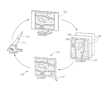
[0012] FIGURE 1A is a process diagram showing a digital paper-enabled product
according to an embodiment of the present invention;
[0013] FIGURE 1B is a process diagram showing the making of a digital paper-
enabled product according to an embodiment of the present invention;
[0014] FIGURE 2 is a top plan view of a prior-art sheet of digital paper with
a
desired pattern applied thereon;
[0015] FIGURE 3 is a top plan view of a prior-art document having map features
printed thereon; and
[0016] FIGURE 4 is a top plan view of a digital paper-enabled document having
action palettes according to an embodiment of the present invention.
DETAILED DESCRIPTION OF THE PREFERRED EMBODIMENT
[0017] In the following description, certain specific details are set forth in
order to
provide a thorough understanding of various embodiments of the invention.
However,
one skilled in the art will understand that the invention may be practiced
without these
details or with various combinations of these details. In other instances,
well-known
systems and methods associated with, but not necessarily limited to, spatial
information
systems, digital paper systems, digital pens and methods for operating the
same may not
be shown or described in detail to avoid unnecessarily obscuring descriptions
of the
embodiments of the invention.
[0018] The present invention is generally directed to a digital paper-enabled
product for digital data collection using digital paper systems, such as maps,
blueprints,
diagrams, CAD drawings, and other documents having spatially relevant
information
printed or applied thereon. The digital paper-enabled product allows a user to
create,
import, edit, share, and act on paper-based data in and between geographic
information
systems (GIS). In one embodiment, the system is compatible with geodatabase
feature
classes, such as personal and enterprise ArcSDEO. In the same or alternate
embodiment,
the system enables the user to print out any ArcGISO map and feature legend on
digital
paper, and then make changes and annotations to the map by simply writing on
the
printed map with a writing utensil, such as a digital pen.
[0019] At least one embodiment of the present invention relates generally to a
digital paper-enabled product having digital paper with a digital pattern that
spatially
cooperates with one or more features or boundaries printed on the pattern, and
more
- 4 - BLACK LOWE & GRAHAM
25315 ADPX-11-1007AP--1k"
701 Fifth Avenue, Suite 4800
CUSTOMER NUMBER Seattle, Washington 98104
Irv: 2521 2.2AA = 'G. onr. aQ1 22111
CA 02690695 2009-11-09
WO 2008/141250
PCT/US2008/063344
specifically to spatial information systems that manage the features or
boundaries and
communicates with a writing instrument previously used to effect changes to
the digital
paper-enabled product. In one embodiment of its product form, the digital
paper-enabled
product may take the form of a sheet of digital paper bearing a digital
pattern and where
features (e.g., such as map features) or a spatial reference frame are printed
onto the
digital pattern and where at least one action palette is printed onto the
digital pattern,
correlated therewith, and usable to effect changes to the features. Other
embodiments
include a method of making the digital-enabled product, a method of processing
information obtained from the digital paper-enabled product, and a method of
using the
digital paper-enabled product. By way of example, a user may use a writing
instrument or
indication device, such as a digital pen, to alter one or more aspects (e.g.,
the features,
boundaries, etc. printed on the digital pattern) through executable actions
produced by
interaction of the writing instrument with the digital paper-enabled product.
[0020] In one aspect of the present invention, a digital paper-enabled product
includes a digital paper system comprised of a physical document bearing a
digital
pattern and having at least one identifiable region spatially correlated to
the digital
pattern using a first coordinate system. The product further includes an
action palette
overlaid onto and spatially correlated to the digital pattern using a second
coordinate
system, the action palette having at least one symbol that is selectable by a
selection
device to generate an editorial action with respect to a feature managed by a
spatial
information system, wherein the editorial action occurs within the at least
one
identifiable region.
[0021] In another aspect of the present invention, a method of making a
digital paper-enabled product includes the steps of (1) arranging at least one
symbol
within an action palette, which includes a first coordinate system co-operable
with a
digital pattern carried by a document, the at least one symbol manageable by a
spatial information system and having a spatial relationship to at least one
other
feature managed by the spatial information system; (2) selecting a spatial
reference
frame having a second coordinate system co-operable with the digital pattern
carried
by the document; (3) applying the action palette onto the digital pattern of
the
document, wherein the at least one symbol becomes spatially determinable using
the
first coordinate system in conjunction with the digital pattern; (4) applying
the
spatial reference frame onto the digital pattern of the document, wherein the
spatial
- 5 - BLACK LOWE & GRAHAM
25315 ADPX-11-1007AP--1k"
701 Fifth Avenue, Suite 4800
CUSTOMER NUMBER Seattle, Washington 98104
Irv: 2521 2.2AA = 'G. onr. aQ1 22111
CA 02690695 2009-11-09
WO 2008/141250
PCT/US2008/063344
reference frame includes at least a bounded region that is spatially
determinable
using the second coordinate system in conjunction with the digital pattern;
and (5)
positioning the action palette with respect to the spatial reference frame on
the
document.
[0022] In yet another aspect of the invention, a method of processing
information obtained from a digital paper-enabled product includes (1)
receiving
information with a writing utensil that indicated a modification of at least
one feature
of the digital paper-enabled product, the at least one feature having a
property
associated therewith and correlated to a digital pattern on digital paper; (2)
placing
the writing utensil in communication with a spatial information system
configured to
manage the at least one feature; (3) transferring the information from the
writing
utensil to the spatial information system to update the property of the at
least one
feature within the spatial information system; and (4) synchronizing the
spatial
information system to generate an updated version of the digital paper-enabled
product.
[0023] And still yet in another aspect of the invention, a method of using a
digital paper-enabled product when de-coupled from a spatial information
system
includes the steps of (1) accessing the digital paper-enabled product having a
sheet of
digital paper bearing a digital pattern and having at least one identifiable
region
spatially correlated to the digital pattern with a coordinate system; (2)
indicating on
the product an editorial action effecting a property of a feature managed by a
spatial
information system; and (3) recording the editorial action with an indicating
device.
[0024] FIGURES 1A and 1B show a digital paper-enabled product 100 having a
spatial information system 102 with data stored, managed or otherwise
controlled
therein. In the illustrated embodiment, the spatial information system 102
takes the
form of computational processing device, such as a computing device, which may
be, but is not limited to, a personal, mainframe, handheld, or other type of
computer
with sufficient memory and computing capacity to process the data. The data,
in
turn, may digitally define features, icons, graphical elements, symbols,
characters,
indicia, mathematical or computational elements, or any other feature
(hereinafter
generally referred to as feature or features) that may be used to represent
some
portion of a map, blueprint, drawing, photo, image, diagram, or other
document. The
features may have spatial relationships with respect to one another, to a
desired
- 6 - BLACK LOWE & GRAHAM
25315 ADPX-11-1007AP--1k"
701 Fifth Avenue, Suite 4800
CUSTOMER NUMBER Seattle, Washington 98104
Irv: 2521 2.2AA = 'G. onr. aQ1 22111
CA 02690695 2009-11-09
WO 2008/141250
PCT/US2008/063344
coordinate system, and to their location on a digital pattern on a sheet of
digital
paper. By way of example, the features may be geo-spatial features used to
produce
a map. In one embodiment, the spatial information system 102 takes the form of
an
ARCGIS system and includes computational, design, display and other tools for
modeling geographic information. It is appreciated that the spatial
information system
may take other forms that are unrelated to geo-spatial or geo-relational data.
Further to
the example, the ARCGIS system may allow a user to author data, maps, globes,
and
models on a desktop or laptop computer; serve them to a geographic information
system
(GIS) server; and access the data through the intern& and mobile clients.
[0025] The digital paper-enabled product 100 includes digital paper 104
(FIGURE 2) having a digital pattern 106 (FIGURE 2) applied thereon and at
least a
spatial reference frame 108 or feature 110 (e.g., terrain, physical object,
symbol, and
any suitable representation thereof) (FIGURE 3) arranged on the digital paper
104.
The digital paper 104 may include boundaries (height = X; width = Y) that are
adaptable to various size sheets and customizable as desired for a variety of
applications. The digital paper 104 may also be referred to as interactive
paper. In
one embodiment, the spatial reference frame 108 may take the form of a
bitmapped
boundary without any other features 110 located therein, such that the
features 110
are to be added by a user after the boundary has been printed onto the digital
pattern
106.
[0026] The digital pattern 106 may interact with writing utensil 112, which
may
otherwise be referred to as an indicating device or a selection device that
may or may not
employ ink during use. By way of example, the writing utensil 112 may take the
form of
a digital pen used to mark on, select, indicate, or otherwise interact with
the spatial
reference frame 108 and/or one or more action icons or features 110. The
digital pattern
106 may generally take the form of a dot pattern that uniquely identifies
positional
coordinates on the digital paper 104 and particularly within the spatial
reference frame
108. In one embodiment, the pattern 106 takes the form of an ANOTO pattern.
The
writing utensil 112 may be used to store, record or even contemporaneously
transmit any
information such as any marks, selections, indications or interactions that
effect one or
more of the features 110. Information stored or recorded may be transmitted or
uploaded
to the spatial information system 102 at a later time, for example when the
user docks the
digital pen into a docking station 111 coupled to the spatial information
system 102.
- 7 - BLACK LOWE & GRAHAM
25315 ADPX-11-1007AP--1k"
701 Fifth Avenue, Suite 4800
CUSTOMER NUMBER Seattle, Washington 98104
Irv: 2521 2.2AA = 'G. onr. aQ1 22111
CA 02690695 2009-11-09
WO 2008/141250
PCT/US2008/063344
[0027] Once the spatial reference frame 108 and/or features 110 have been
applied onto the digital pattern 106, for example printed onto the digital
pattern 106,
the resulting document may be referred to as a digital paper-enabled document
114.
The spatial reference frame 108 and/or features 110 may or may not be visible,
and
may be editorially actionable or benign. The term editorial action as used
herein may
refer to a variety of interactions, requests, selections, queries and other
activities that
may be expressly initiated by the user and/or interpreted with respect to the
digital
paper-enabled document 114. By way of example, the user may query information
from the document 114, such as route distances (as traveled or point-to-
point),
request general details about one or more features (e.g., request the square
footage
and number of floors of a selected building), find a desired business
location, locate all
features of a certain type within the operable boundaries of the document 114,
and many
other tasks or actions. Editorial action may further refer to spatial data
actions, such as
spatial queries and spatial processing activities, which may include creation,
review,
update, and deletion. A query may include querying to a list, for example
creating,
importing, editing, and sharing information with regards to a list or data
table.
[0028] Referring to FIGURE 4, when the digital document 114 is generated
(e.g., printed), the printed version may be referred to as a static or frozen
version
because changes to the document may only be made through interaction with an
active version (e.g., digitally accessible) or through interaction with the
writing
utensil 112 (FIGURE 1) as described below.
[0029] Referring briefly back to FIGURE 1 and by way of example, the writing
instrument 112 may provide a series of ink strokes placed on one or more pages
of the
digital paper 104, where the location of each stroke relative to the
underlying pattern 106
is recorded. This information may then be received by the spatial information
system 102
such that the digital document 114 may be updated based on the actions or
operations of
the writing instrument 112 remote from spatial information system 102. For
example, if
the digital paper 104 was printed with an image displayed thereon, the
location of the
strokes could be determined relative to the image or portions of the image
using one or
more coordinate systems associated with the digital pattern 106. Through this
analysis,
the product 100 may interpret what the user meant to do when placing the
strokes on the
document 114. These aspects of the invention and more are explained in more
detail
below in the description related to the legend and palette.
- 8 - BLACK LOWE & GRAHAM
25315 ADPX-11-1007AP--1k"
701 Fifth Avenue, Suite 4800
CUSTOMER NUMBER Seattle, Washington 98104
Irv: 2521 2.2AA = 'G. onr. aQ1 22111
CA 02690695 2009-11-09
WO 2008/141250
PCT/US2008/063344
[0030] In one embodiment, the ink strokes from the writing utensil 112 are
assigned a meaning or alternatively stated the strokes are assigned semantics
that
correlate the actions of the writing utensil 112 with features, images, or
other geo-spatial
information printed on the digital paper 104. By way of example, the product
100
attempts to decide what areas the user intended the ink stroke to cover by
counting what
ratio of the stroke was in each region or area of the digital paper, and then
assigning that
stroke to the area in which the majority of the stroke occurred. The
"majority" decision
may be resolved by counting points in the stroke, or by weighting the length
of each
segment of the stroke.
[0031] In another embodiment, the product 100 applies an algorithm to denote
certain areas (e.g., the boundaries of a legend located on a printed map) as
being higher
priority than the map area. The algorithm divides the ink stroke into many
equally spaced
points, and then for each point, assigns that point to the highest-priority
area for which it
is located within (note that a single point could be inside multiple areas,
with overlapping
areas.) Then, the algorithm chooses the highest priority level for which any
points were
found, and examines that priority level to discover which area had the most
votes or the
highest value at that priority level. The "high value" area becomes the area
to which the
stroke is assigned. Using this system, the user may have any number of
overlapping areas,
and their semantics may be kept distinct, as long as the ink strokes are
assigned distinct
priority levels by the decisions made when the writing utensil is used to
originally mark
on the digital paper 104.
[0032] The digital paper-enabled product 100 integrates the spatial
information
system 102 with the digital paper 104 according to an embodiment of the
present
invention. More specifically, the digital paper-enabled product 100 provides
for a user or
multiple users to create, revise, update, delete and possibly review the
frozen version of
the digital document 114 through interaction with the writing instrument 112
and/or
through direct interaction with an active version of the digital document 114.
[0033] Digital-paper-enabling as used herein includes providing the ability to
create, modify and/or delete portions and sub-portions of the spatial
information system
102, to include the underlying modeling data that may define one or more
attributes or
values for the features that may be printed on the digital paper 104. Again,
the features
may include any feature that has some spatial relationship to other features
to form a map,
CAD drawing, diagram, etc.
- 9 - BLACK LOWE & GRAHAM
25315 ADPX-11-1007AP--1k"
701 Fifth Avenue, Suite 4800
CUSTOMER NUMBER Seattle, Washington 98104
Irv: 2521 2.2AA = 'G. onr. aQ1 22111
CA 02690695 2009-11-09
WO 2008/141250
PCT/US2008/063344
[0034] As will be described in greater detail below, the digital paper-enabled
product 100 integrates the spatial information system 102 with the digital
paper 104 to
create both active and frozen versions of maps, diagrams, CAD drawings, and
other such
digital documents 112 that may be modified in some manner by one or more
users. The
operation of the product 100 may include the following processes: (1)
generating the
digital document 114, also referred to as a display model 114, from the
spatial
information system 102, such as generating at least a portion of the map,
diagram or CAD
drawing; (2) interacting with the display model 114 using the writing utensil
112 through
an active legend and possibly through an action palette (both of which are
described
below); (3) connecting the results of the user's interactions on the frozen
version of the
display model 114 to the spatial information system 102; and (4) processing
the data
received by the writing utensil 112 to update the spatial information system
102 and in
turn update the display model 114.
[0035] Generating the display model or digital document 114 from the spatial
information system 102, which may include, but is not limited to, generating
at least a
portion of the map, diagram or CAD drawing, and may involve creating features
by
querying the spatial information system 102 and then generating two-
dimensional or
three-dimensional graphical elements (e.g., points, lines, curves, etc.) to
form the
document 114. The data within the spatial information system 102 provides the
definitions, boundaries, attributes, actions and other aspects of the features
110 using
associated attribute tables, value tables, property tables, coordinate tables,
etc., which
may or may not be combined into a single table. Alternatively, generating the
display
model 114 may involve querying the spatial information system 102 to generate
non-
spatial graphical representations such as forms or data grids, which may be
filled in by the
user. In turn, the data may be altered without further querying the spatial
information
system 102 and then re-inserted into the spatial information system 102 at a
later time.
[0036] In another embodiment, generating the display model or digital document
114 may include the generation of semantic descriptions by querying and
analyzing the
spatial information system 102. The semantic descriptions are those derived by
an
interpretation of the user's actions when interacting with the product 100.
[0037] The product 100 is an interactive system, meaning that in most
instances
the user may interact with the digital paper 104 with the writing utensil 112.
In one
embodiment, the product 100 is configured to permit the user to communicate
with the
- 10- BLACK LOWE & GRAHAM
25315 ADPX-11-1007AP--1k"
701 Fifth Avenue, Suite 4800
CUSTOMER NUMBER Seattle, Washington 98104
Irv: 2521 2.2AA = 'G. onr. aQ1 22111
CA 02690695 2009-11-09
WO 2008/141250
PCT/US2008/063344
writing utensil 112 while the system interprets or attempts to interpret the
user's
intentions.
[0038] Referring again to FIGURE 4 and by way of example, the digital
document 114 takes the form of a digital map 112 printed onto the pattern 106
of the
digital paper 104 and includes a first action palette 116 and a second action
palette 118
(hereinafter referred to as a legend 118). Both the palettes 116, 118 may
include action
icons or features 110. In one embodiment, the first action palette 116
includes action
icons that invoke a desired "action" related to the spatial data located on
the
document 114. And, the second action palette or legend 118 includes features
110
that may or may not have encoded or embodied actions pertaining thereto. Thus,
the
features 110 in the legend 118 may take the form of representations relevant
to the
document 114. For a map, for example, the features 110 may be roads, bridges,
walkways, landmarks, signs, etc. For a blueprint, the features 110 may be
building
furnishings, offices, restrooms, etc. For CAD drawings, the features 110 may
be
gears, levers, rods, hydro-mechanical symbols, electrical symbols, computer
symbols, etc.
[0039] Interacting as used herein generally refers to using a document with
spatially interacting features printed on digital paper, which may include the
ANOTOO
pattern printed under the features as a watermark. In the field, the user may
create, edit,
move, and delete features on the document with a writing utensil by selecting
items from
a legend and placing them on the document. The user may also select desired
editorial
actions from an action palette. After the document has been annotated, the
associated data
may be uploaded into a spatial information system 102 to interpret the strokes
of the
writing utensil 112 and then accurately integrate any changes into a new
version of the
document 114, which may be printed at a later time.
[0040] When interacting with the frozen version of the digital document 114,
the
user may use the writing instrument 112 to select the editorial action in the
first action
palette 116 (e.g., add, revise, move, delete, etc.), then select the feature
in the legend 118,
and then select a point or region on the map 112 outside of the boundaries of
the legend
118 and palette 116. For example, the map 112 may be a representation of
several city
blocks and the user may want to add features to the map 112 for an upcoming
parade and
then provide the revised map 112 to parade organizers. While in the field, the
user may
select the "add" icon from the action palette 116 on a frozen version of the
map 112, then
- 11 - BLACK LOWE & GRAHAM
25315 ADPX-11-1007AP--1k"
701 Fifth Avenue, Suite 4800
CUSTOMER NUMBER Seattle, Washington 98104
Irv: 2521 2.2AA = 'G. onr. aQ1 22111
CA 02690695 2009-11-09
WO 2008/141250
PCT/US2008/063344
select the "set of bleachers" feature from the legend 118. And still using the
writing
instrument 112, the user places the bleachers along a desired street displayed
on the map
112. Likewise, the user may take other or subsequent actions like "revise,"
"move," or
"delete" with respect to the same or other features provided in the legend
118. Again,
such interactions are not limited to maps, but may be for other documents such
as
blueprints, CAD drawings, diagrams, etc. In one embodiment, the legend 118
and/or the
palette 116 are not located on the digital document 114, but instead displayed
on a
separate tablet or device, such as, but not limited a handheld computing
device, personal
computing tablet, or equivalent device.
[0041] Once again referring back to FIGURE 1, the writing instrument 112 is
configured to cooperate with the active legend 118 to select a desired feature
and to
cooperate with the action palette 116 to receive an actionable command. The
information recorded by the writing instrument 112 may be downloaded to the
spatial information system 102 through a variety of means, such as the docking
station 111 having a USB cable or a wireless (e.g., Bluetooth) connection to
the
spatial information system 102. The writing utensil 112 may use ink or an
equivalent,
visible marking substance as it captures the writing digitally with an
infrared camera. The
writing utensil 112 may further include an image processor, a memory and a
rechargeable
power supply.
[0042] When interacting, the user's actions with the writing utensil 112 may
indicate that data is to be created, edited, moved, or deleted and further
provide an
indication of what action or actions were to occur next. For example, the user
may desire
to create or add a bus stop at a desired location of a blueprint for a transit
system. The
user takes steps similar to those discussed above and thus the "add" action
may become
semantically grounded within the product 100.
[0043] In another example, the user may choose to delete the bus stop or an
entire
portion of the transit system. The deletion of the bus stop may be indicated,
in part, by the
deletion of what had once been a transit transfer point by selecting this item
or feature
from the active legend 118 in combination with the icon from the action
palette 116. In
one embodiment, the action may be bounded by a domain of accepted values
corresponding to the selected feature. The domain of selected values may
include, but not
limited, dimensions, type, material, interface requirements, etc. In addition,
when the
feature is placed using the writing utensil 112, it may be spatially bounded
or constrained
- 12- BLACK LOWE & GRAHAM
25315 ADPX-11-1007AP--1k"
701 Fifth Avenue, Suite 4800
CUSTOMER NUMBER Seattle, Washington 98104
Irv: 2521 2.2AA = 'G. onr. aQ1 22111
CA 02690695 2009-11-09
WO 2008/141250
PCT/US2008/063344
by delineating (e.g., drawing or marking) a boundary or perimeter around the
feature with
the writing utensil. The delineation of the boundary may also be used to
indicate the
movement, revision, or deletion of whole classes of features. In yet another
type of
interaction, the product 100 may determine a route from a first location to a
second
location when the user selects each location, in order, with the writing
utensil 112. After
such a selection, the user may select an icon on the action palette 116
identified as
"calculate route," or "determine distance," or any other type of route-related
information.
The product 100 then performs the action and reports the results to the user
through a
display interface, such as a computer screen.
[0044] As described above, the user, though the use of the digital paper 104,
may
bring the spatial information system 102 or a portion thereof in the form of a
frozen
model 114 (e.g., map) with them into a field environment and interact directly
with the
model 114. However, the actions taken may not automatically be applied in real
time to
the spatial information system 102 or the model 114. To bring effect to the
actions, the
user will have to connect at least the writing utensil 112 to the spatial
information system
102. Such a connection may take various forms, such as, but not limited to a
wireless or
Bluetooth transmission either in real time or in a batch mode, a wired
connection, for
example through a USB cable, or some other known method of transferring data
from one
device or system to another. The product 100 may include various checks and
balances
during data transmission to insure the data is transmitted completely and
correctly to the
spatial information system.
[0045] In one embodiment, the transmission of the data includes transmitting
the
data from the digital paper system 104 to a local computing or data storage
system that is
not able to actively update the spatial information system 102. And then, the
data may be
re-transmitted from the local computing or data storage system to an active or
updatable
version of the spatial information system. In one embodiment, such a re-
transmission may
be performed by a COVELUSTM cell phone routing system. Advantageously, the
initial
transmission and re-transmission of the data may be performed concurrently,
thus
providing almost immediate feedback for the user or a reviewer. It is
appreciated that the
spatial information system 102 and the data used to generate the digital
documents 112
may reside on a single or central system and that updates may only be
effective when a
connection is made with the single or central spatial information system 102.
- 13 - BLACK LOWE & GRAHAM
25315 ADPX-11-1007AP--1k"
701 Fifth Avenue, Suite 4800
CUSTOMER NUMBER Seattle, Washington 98104
Irv: 2521 2.2AA = 'G. onr. aQ1 22111
CA 02690695 2014-10-22
[0046] Processing includes applying the user's intentions to the spatial
information
system 102 and to the model or document 114 and may further include
interpretation of the
user's intentions. In addition and after processing, all changes or only
certain changes may be
process for review, correction, and acceptance as a way to validate the
interpretations.
[0047] Processing may include receiving information from the writing utensil
112 and
interpreting at least portions of that information based on a form relevant to
the domain of the
spatial information system 102 and in accordance with any supported CRUD
actions. In one
embodiment, processing may take the form of creating a feature class instance,
which can be
formed by the contextual information (say school house), spatial information
(say geo-
coordinates 140.9023E,50.33321N), and [optionally] explicit information from a
particular
entry (say K-5, 425 students, 25 teachers). The creation and initialization of
the feature class
instance may then be added to a layer that contains such objects (from the map
used to
generate the original writing surface).
[0048] As briefly discussed above, processing may include interpreting the
user's
intentions and/or interactions through the processes of assignment and
annotation. The user's
intentions and/or interactions may be processed based on their semantic
context. In the case of
a stroke written upon the simple palette of an ArcGIS map, a user intention
to create or add
desired feature may be interpreted by the user not selecting any conflicting
actions from the
action palette 116. This interpretation may become the default for any
following strokes.
[0049] While the preferred embodiment of the invention has been illustrated
and
described, as noted above, many changes can be made without departing from the
scope of the
invention. Accordingly, the scope of the invention is not limited by the
disclosure of the
preferred embodiment. Instead, the invention should be determined entirely by
reference to
the claims that follow.
- 14-