Note: Descriptions are shown in the official language in which they were submitted.
CA 02691171 2013-11-08
PORTABLE NAVIGATION SYSTEM
FIELD OF THE INVENTION
[0001] The present invention relates generally to a portable navigation system
adapted for use by an individual both when on foot or in a vehicle or on a
moving
platform, for the purpose of navigation and positioning.
BACKGROUND OF THE INVENTION
[0002] The common practice in the field of portable navigation is the use of
GPS-
only systems. The position and/or velocity information from the GPS receiver
is
displayed on a digital map to identify the location of the user. However, GPS
is not
reliable as it needs a direct line of sight to at least four different GPS
satellites and the
line of sight may be interfered with, for example by trees when in a forest or
blocked,
for example when in a tunnel.
[0003] Inertial sensors are self-contained sensors that sense the changes in
accelerations and angular rates of the conveying body. These sensors are
sometimes
used to bridge the GPS signal outages if they are tethered with the moving
body in a
well defined orientation. The tethered and well aligned constraints make the
device
application specific and not user friendly.
[0004] Navigation when using an assembly of inertial sensors has heretofore
involved
the use of different navigation algorithms for different transit/conveyance
modes.
Consequently, there has been no commercially available system known to us that
can
provide seamless navigation (position, velocity and attitude) information,
when
multiple modes of conveyance are involved, due to the fact that different
algorithms
have been used. More specifically, the on-foot mode of transit is implemented
by
using pedestrian dead reckoning (PDR) algorithm to avoid the huge drifts
associated
with the integration of inertial signals. However, PDR requires assumptions
that must
be satisfied for all type of walking modes. For example, climbing up the
stairs require
different assumptions for stride length and step detection threshold than
going down
the stairs. In addition, the in-vehicle navigation mode cannot be implemented
using
PDR and needs mechanization algorithm. Hence, two algorithms are used for the
two
most common transit modes. It is important for the system to recognize the
1
CA 02691171 2013-11-08
appropriate mode of transit to switch between the modes otherwise the system
will
not work well. A mechanization algorithm for on-foot is not desirable due to
the
quadratic drift of derived navigation parameters with time. This problem has
been
resolved in the prior art as follows:
1) Use of wireless only positioning (GPS or cellular signals triangulation)
for
different transit modes (such as positioning used in iPhone). Wireless
positioning has only one algorithm no matter what the mode of transit is.
However, as previously stated, wireless signals require line of sight to four
different signal sources (such as four GPS satellites in case of GPS
positioning) to provide a position. Unfortunately, this condition cannot be
satisfied all the time;
2) Use of a physical switch, such as cables or tethering inside a land
vehicle, to
ensure that mechanization algorithm is used for in-vehicle navigation. If in
doubt, such systems use wireless only navigation. If wireless only navigation
is unavailable, then the user simply doesn't get the navigation information;
or
3) Design separate systems, if seamless positioning using inertial sensors is
desired, for on-foot and in-vehicle navigation, to ensure the desired use of
the
navigation system.
SUMMARY
[0005] The challenge is to provide a user-friendly system:
= that does not need to be tethered and precisely aligned in either on-foot
or on a moving platform mode of transit;
= that provides a useful navigation solution for either mode of transit or
conveyance, preferably using a single navigation or core algorithm and
constraining drifts of the navigation algorithm during on-foot mode,
for example by using updates from PDR without any assumptions; and
= that is preferably capable of GPS integration along with inertial sensor
based positioning without assumptions.
[0006] The objective of the present invention is therefore to provide a
portable
navigation system (`PNS') module adapted to seamlessly produce a navigation
2
CA 02691171 2013-11-08
solution pertaining to the module, for both in-vehicle (including a moving
platform)
and on-foot modes of transit.
[0007] The PNS module utilizes two independent sources of navigational
information. It melds the information, when both sources are available, to
produce
the navigation solution; or it can produce the solution using the information
from only
one source, when the information from the other source is temporarily
unavailable.
Thus the output of the module is seamless or continuous.
[0008] More particularly, the PNS module incorporates:
= a receiver, such as a GPS receiver, for receiving navigational
information from
an external source, such as GPS satellites. The receiver produces an output of
absolute navigational information pertaining to the module, in the form of
signals indicative thereof;
= an assembly of sensors for generating navigational information at the
module.
The sensor assembly produces an output of measured navigational information
pertaining to the module, in the form of signals indicative thereof; and
= a processor coupled to the receiver and sensor assembly for receiving
their
signals and programmed to accomplish the following:
o determining the mode of conveyance of the module;
o determining the orientation of the sensors; and
o using the absolute and measured navigational information, together
with the mode of conveyance and orientation information, to determine
and produce the navigation solution. The solution will provide
positioning and heading information of the user and module, such as
instantaneous position, velocity and attitude information.
[0009] The processor is preferably programmed with:
= a mechanization navigation algorithm for converting the sensor
measurements
to relative navigational information;
= a conveyance algorithm for using the composite absolute and relative
navigational information to establish the mode of conveyance;
= an orientation algorithm for using the composite navigational information to
establish the orientation of the sensors; and
3
CA 02691171 2013-11-08
= a core or navigation algorithm for using the composite navigational
information, the mode of conveyance information and the orientation
information to determine and produce a filtered navigation solution.
[0010] By initially determining the mode of conveyance and the orientation of
the
sensors, the core navigation algorithm is able to select and use appropriate
constraints
to ameliorate errors (such as drift) arising from the sensors.
[0011] By way of example, if the mode of conveyance is determined to be on-
foot,
the core navigation algorithm can be aided by a pedestrian dead reckoning
(PDR)
algorithm to limit sensor drift.
[0012] Optionally, the navigation solution may be communicated to a display
and
shown thereon. The display may be part of the module body, or may be separate
from
and wirelessly connected to the module.
[0013] In another aspect, a method is provided for seamlessly producing a
navigation
solution using a portable navigation system module, comprising:
= receiving navigational information at the module from an external source and
producing signals indicative thereof;
= generating navigational information at the module using sensors and
producing signals indicative thereof;
= determining the mode of conveyance of the module using navigational
information derived from the receiver and sensor signals and producing
information indicative thereof;
= determining the orientation of the sensors using navigational information
derived from the receiver and sensor signals and producing information
indicative thereof; and
= processing and filtering the navigational information, the mode of
conveyance
information and the orientation information to determine and produce a
navigation solution.
[0014] Optionally, the filtered navigation solution is displayed, either at
the module
or at another location.
[0015] Broadly stated then, a system is provided which combines:
4
CA 02691171 2013-11-08
= providing and using a composite of navigational information, derived from
an
external source and measured at the module with sensors, to determine the
mode of conveyance of the module and the orientation of the sensors; and
= using the composite navigational information, the mode of conveyance
information and the orientation information to produce a navigation solution
pertaining to the module using an appropriately aided core navigation
algorithm.
[0016] In the event the navigational information from the external source is
temporarily not available, the system produces the solution using only the
information
measured by the sensors.
DESCRIPTION OF THE DRAWINGS
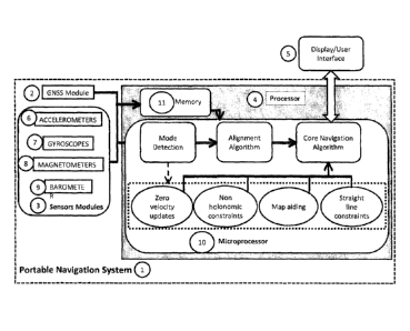
[0017] Figure 1 is a block diagram of a navigation module according to the
present
invention;
[0018] Figure 2 is a flowchart illustrating the mode of conveyance algorithm;
and
[0019] Figure 3 is a flowchart illustrating the core algorithm.
DESCRIPTION OF THE PREFERRED EMBODIMENT
[0020] In the development of the present system, the information contained in
the
thesis of Dr. Zainab Syed was used. The thesis is available at
http ://www. ucalgary. ca/engo_webdoc s/NE S/09.20288 .Zainab . Syed. pdf. It
provides
background and guidance with respect to the system and its disclosure.
[0021] In one embodiment, a portable electronic module 1 is provided which
comprises a GPS receiver 2, an assembly 3 of sensors, a processor 4 and a
display 5.
[0022] The GPS receiver 2 receives navigational information in the form of
signals
from GPS satellites and converts the information into position and velocity
data
(referred to as 'absolute navigational information'). The receiver produces
the data in
the form of signals indicative thereof.
[0023] The sensor assembly 3 comprises: accelerometers 6 for measuring module
accelerations; gyroscopes 7 for measuring module turning rates; magnetometers
8 for
measuring magnetic field strength for use in establishing module heading; and
a
5
CA 02691171 2013-11-08
barometer 9 for measuring pressure for use in establishing altitude changes.
The
sensor assembly 3 generates data indicative of these measurements, in the form
of an
output of signals. It will be noted that the sensor assembly 3 generates this
information at the module. The information so produced is used to compute
'relative
navigational information' pertaining to the module.
[0024] As a minimum, the sensor assembly 3 may get by with inertial sensors,
namely two accelerometers for monitoring forward/ backward and lateral
directions
and a vertical gyroscope for monitoring heading rate. However, a full
complement of:
three accelerometers (for forward/backward, lateral and vertical accelerations
monitoring); and three gyroscopes (two horizontal gyros for measuring roll and
pitch,
and a vertical gyro for measuring heading) is preferably utilized for the most
accurate
solution.
[0025] The receiver 2 and sensor assembly 3 are coupled to the processor 4 so
as to
communicate thereto the absolute navigational information and the sensors'
data.
This may be done using, for example, a Texas Instruments MSP430 family or
other
basic microcontroller to capture and time synchronize all the sensor data
before
transferring the data to a higher powered processor such as an ARM9 based unit
or
other dedicated DSP for the navigation processing.
[0026] The processor is programmed with: a mechanization algorithm for
converting
the sensor data to relative navigational information by using mechanization
equations
such as are described in section 2.3 of Syed's thesis; a conveyance algorithm
for using
the composite navigational information to establish the mode of conveyance; an
orientation algorithm for using the composite navigational information to
establish the
orientation of the sensors; and a core algorithm (for example an extended
Kalman
Filter as discussed in sections 2.4 and 2.5 of Syed's thesis) for using the
navigational
information, the mode of conveyance information and the orientation
information to
determine and produce a filtered navigation solution.
[0027] As previously stated, the solution is seamless ¨ that is, it is
produced
continuously even though the GPS may temporarily be inoperative.
[0028] In an experimental prototype, the GPS receiver 2 used was an Antaris
LEA-4T
receiver module; and the sensor assembly 3 comprised: three orthogonal Micro-
Electro-Mechanical Systems MEMS accelerometers (model LIS3L02AL, available
6
CA 02691171 2013-11-08
from ST Microelectronics); three orthogonal MEMS gyroscopes (model LISY300AL,
available from ST Microelectronics); three orthogonal magnetometers (model HMC
5843, available from Honeywell); and a barometer (model 1451, available from
MSI
Sensors).
[0029] The processor 4 comprised a micro-processor 10 and memory 11. The micro-
processor 10 was programmed as stated to apply the algorithms, which utilized
the
composite absolute navigational information and sensors data stored in memory
buffer.
[0030] More particularly, a mechanization algorithm was applied by the
processor 4
to the data incoming from the sensor assembly 3, to convert the data to
relative
navigational information. This was accomplished by applying mechanization
equations, trigonometric identities and pressure to height conversion
formulas.
Guidance in this regard is provided in the Syed thesis where section 2.3
contains
information about a mechanization algorithm and heading estimation using
magnetometers. The pressure can be changed into height by following the steps
provided in Ranta-aho 2003 which can be accessed at
http://wwvv.vaisala.com/files/height_calculation.pdf.
[0031] Using the available absolute and relative navigational information
derived
from the receiver 2 and sensor assembly 3, (said information being referred to
herein
as 'the composite navigational information'), the mode of conveyance algorithm
was
applied to establish the mode of module conveyance. The mode of conveyance
algorithm uses inertial, magnetometer and barometer signals to determine the
physical
state of the sensor module, i.e., if the module is carried by a person or
inside a land
vehicle. After the mode of conveyance is established, two distinct alignments
were
determined, specifically: (1) the alignment between the moving body, for
example the
user or vehicle, and the module; and (2) the alignment of the moving body in
the
navigation frame. The former is referred to as the relative alignment or
orientation
while the latter is referred to as the absolute alignment. The means for
accomplishing
this utilized an Extended Kalman filter which estimated the misalignment error
states
between the moving body and the module. The filter used updates from: physical
constraints, namely straight line velocity constraints or non holonomic
constraints; the
GPS measurements; gravity measurements; and zero velocity periods; to converge
to
7
CA 02691171 2013-11-08
the true values. The misalignment Extended Kalman Filter (EKF) used is
provided in
section 6.2.4 in Syed's thesis. In conjunction therewith, the core algorithm
estimated
the errors in the absolute alignment using heading updates taken from the
magnetometers and/or derived using instantaneous velocity values from the GPS
information.
[0032] Following are the details of the algorithms used in the prototype.
[0033] For mode detection, the accelerometer and gyroscope information was
checked first at the highest frequencies, typically above 1 Hz. The
magnetometer
information was checked for repetitive attitude changes between 1 and 2
seconds,
which would indicate walking. The barometer information was checked over 2 to
4
seconds for repetitive signal changes which would occur during walking due to
repetitive height and pressure changes. Lastly, a platform mode was checked
based
on large velocities of the combined sensor and/or GPS information, beyond what
a
human could achieve on foot over a non-moving surface. The entire process was
always occurring with update rates of 2-4 seconds.
[0034] The mode of conveyance could be:
1. Undetermined ¨ in which case the core algorithm was used without
aiding from the mode of conveyance;
2. On-foot (for example on the belt or in the hand of a user walking on an
immovable object such as a sidewalk); or
3. On-platform (for example, the system was arbitrarily positioned within
a vehicle but without attachment to the vehicle);
4. On-foot on a movable platform (for example, a person walking on a
moving train or bus). In this case, the navigation was performed for
two motions (on-foot motion which is usually low velocity, and
platform motion with higher velocity). The two motions, i.e., on-foot
and platform motion, were identified on the basis of underlying
frequencies using either Fast Fourier Transform (FFT) or wavelets.
The navigation core gave precedence to the high velocity platform and
computed the navigational information. Although not implemented yet,
a separate core algorithm (the second copy of core algorithm) can be
used to compute the navigational information of the low velocity on-
8
CA 02691171 2013-11-08
foot motion depending on microprocessor capabilities. In this case, the
two solutions (high and low velocity) will be combined to contribute to
the overall navigation solution.
[0035] The orientation of the module with respect to the person or platform
was also
needed, to permit the application of aiding sources and constraints to the
navigation
core algorithm. A separate orientation algorithm was therefore always running,
which
provided an estimate of the orientation, along with its perceived accuracy.
The orientation could be:
1. Undetermined;
2. Determined person to module;
3. Determined platform to module; or
4. Determined platform to person to module.
[0036] The detail implementation of the orientation of misalignment algorithm
used,
along with the equations, is given in section 6.2.4 of Syed's PhD thesis.
Furthermore,
in the case that the orientation is undetermined, the produced navigation
solution will
be with respect to the navigation system and will not provide all the
information about
the person's positioning.
[0037] Once the mode of conveyance was established and the standard deviation
dropped below pre-defined thresholds for the orientation algorithm, the aiding
sources
could be applied appropriately. Even after this condition, the orientation
algorithm
was applied continuously, to determine the module's orientation during the
periods of
motion, with accurate GPS updates and estimates of roll and pitch when it was
stationary.
[0038] The following constraints were used in connection with the prototype:
1. Nonholonomic constraints that keep a person or a vehicle moving in a
straight
line, or prevent the vehicle from jumping off the ground. Both the mode of
conveyance and the orientation between the module and the vehicle/person
have to be resolved before this constraint can be applied.
2. Level ground constraint for the stride length for on-foot mode of travel.
Appropriate stride lengths can be estimated using either available techniques
such as walking frequency or pre-training of the system, and fixed for
9
CA 02691171 2013-11-08
computations when walking on level ground. The mode of conveyance has to
be resolved to apply this stride length constraint for level ground.
[0039] The following aids were provided to the core algorithm:
1. Map aiding was applied to both on-foot and in-vehicle modes of conveyance.
The mode of conveyance had to be resolved for this position update to use
appropriate maps/algorithms.
2. Zero velocity update, where the navigation core algorithm was aided by the
physical state of the platform. The algorithm applied no motion as updates to
improve the navigation solution. The mode of conveyance needed to be
determined to trigger appropriate no-motion constraints for different modes of
conveyance.
3. Odometer aiding was also applied during in-vehicle navigation mode, if the
signals were available to the processor. The odometer aiding has shown over
two times improvements of navigation solution when used with the collected
sensor signals. The processing was done in a post-processing configuration.
[0040] Variants:
It is contemplated that various equivalent means can be substituted for the
following elements:
= Cellular phone, WiFi or Bluetooth piconet positioning capabilities can
substitute the GNSS positioning capabilities if GNSS is unavailable; and
= Any type of inertial sensors (not just limited to MEMS based) are
potentially
useful.