Note: Descriptions are shown in the official language in which they were submitted.
CA 02691537 2009-12-21
WO 2009/002699 PCT/US2008/066420
DYNAMIC RESOURCE ASSIGNMENT AND EXIT INFORMATION
FOR EMERGENCY RESPONDERS
BACKGROUND OF THE INVENTION
Field of the Invention
[0001] The present invention generally relates to communications systems and,
more particularly, to emergency response communications systems.
Backaound of the Invention
[0002] Emergency responders at an incident scene often are confronted with a
number of issues, one of which is resource management. During a structure
fire, for
example, an emergency response coordinator typically decides how to allocate
emergency response resources (e.g. personnel, equipment, etc.) to attack the
fire, and
then provides instructions to personnel to implement the resource allocations.
The
decision making process is usually based on situational assessments made by
analyzing human sensory perceptions and by gathering information from
bystanders.
Oftentimes, such perceptions and information gathered are insufficient to
provide
adequate situational awareness. In consequence, the emergency response
resources
may not be allocated in a manner which maximizes their effectiveness.
Moreover,
some emergency response resources may be placed in unacceptably risky
situations.
[0003] Another issue that emergency responders confront is the issue of
planning
for the safe exit of emergency response resources from the incident scene. For
instance, during a structure fire, emergency responders need to be able to
find a safe
exit from the structure should the fire create unacceptably dangerous
conditions
within the structure. Exit signs may be damaged or hidden from view due to
smoke
or debris, however, and certain exit routes also may be blocked. Emergency
1
CA 02691537 2009-12-21
WO 2009/002699 PCT/US2008/066420
responders therefore may be unaware of the safest exit path and may be exposed
to
danger longer than is necessary.
SUMMARY OF THE INVENTION
[0004] The present invention relates to a method of providing situational
awareness at an incident scene. The method can include receiving sensor data
from at
least one sensor located at the incident scene and receiving position data for
at least
one resource located at the incident scene. Based on the received sensor data
and
position data, at least one optimal exit route for the resource to exit a
location at the
incident scene can be calculated.
[0005] The present invention also relates to a system that provides
situational
awareness at an incident scene. The system can include a communications
adapter
that receives sensor data from at least one sensor located at the incident
scene and
position data for at least one resource located at the incident scene. The
system can
also include a processor that calculates at least one optimal exit route for
the resource
to exit a location at the incident scene based on the received sensor data and
position
data.
[0006] The present invention can also be embedded in a program storage device
readable by a machine, tangibly embodying a program of instructions executable
by
the machine to perform the various steps described herein.
BRIEF DESCRIPTION OF THE DRAWINGS
[0007] Preferred embodiments of the present invention will be described below
in
more detail, with reference to the accompanying drawings, in which:
2
CA 02691537 2009-12-21
WO 2009/002699 PCT/US2008/066420
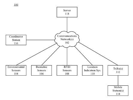
[0008] FIG. 1 depicts a communications system that is useful for understanding
the present invention;
[0009] FIG. 2 depicts a block diagram of a server that is useful for
understanding
the present invention;
[0010] FIG. 3 depicts a map that is useful for understanding the present
invention;
and
[0011] FIG. 4 is a flowchart that is useful for understanding the present
invention.
DETAILED DESCRIPTION
[0012] While the specification concludes with claims defining features of the
invention that are regarded as novel, it is believed that the invention will
be better
understood from a consideration of the description in conjunction with the
drawings.
As required, detailed embodiments of the present invention are disclosed
herein;
however, it is to be understood that the disclosed embodiments are merely
exemplary
of the invention, which can be embodied in various forms. Therefore, specific
structural and functional details disclosed herein are not to be interpreted
as limiting,
but merely as a basis for the claims and as a representative basis for
teaching one
skilled in the art to variously employ the present invention in virtually any
appropriately detailed structure. Further, the terms and phrases used herein
are not
intended to be limiting but rather to provide an understandable description of
the
invention.
[0013] The present invention relates to a method and a system that provides
situational awareness at an incident scene. The system can process sensor data
received from the incident scene and calculate safe exit routes for emergency
3
CA 02691537 2009-12-21
WO 2009/002699 PCT/US2008/066420
responders and other emergency response resources at the scene. For instance,
if
there is a structure fire at the incident scene, the system can calculate safe
exit routes
out of the structure. Further, the system can process sensor data to determine
when
the emergency response resources should begin exiting the structure.
[0014] FIG. 1 depicts a communications system 100 that is useful for
understanding the present invention. The communications system 100 can include
a
communications network 102, which may comprise a wide area network (WAN),
such as the Internet, the World Wide Web, a dispatch communications network,
an
interconnect communications network (e.g. a cellular communications network),
a
public switched telephone network (PSTN), and the like. The communications
network also may comprise a local area network (LAN), a metropolitan area
network
(MAN), a WiFi network, a Mesh network, a public safety network (e.g. Astro,
TETRA, HPD, etc.) and/or any other networks or systems over which
communication
signals can be propagated. In that regard, the communications network 102 can
include wired and/or wireless communication links. The communications network
102 can be configured to communicate data via IEEE 802 wireless
communications,
for example, 802.11 and 802.16 (WiMAX), 3G, 4G, EUTRAN, UMB, WPA, WPA2,
GSM, TDMA, CDMA, WCDMA, OFDM, direct wireless communication, or any
other communications format. Indeed, the communications network 102 can be
implemented in accordance with any suitable communications standards,
protocols,
and/or architectures, or a suitable combination of such standards, protocols,
and/or
architectures.
[0015] The communications system 100 can also include one or more sensors, for
example environmental sensors 104, biometric sensors 106 and/or radio
frequency
4
CA 02691537 2009-12-21
WO 2009/002699 PCT/US2008/066420
identifier (RFID) sensors 108. The environmental sensors 104 can monitor
environmental conditions at the incident scene. For example, the environmental
sensors 104 can monitor temperature, humidity and air quality (e.g. carbon
monoxide
levels, carbon dioxide levels, oxygen levels, nitrogen levels, smoke levels,
airborne
particulates, fumes, leaking gas, etc.). The environmental sensors 104 can
also
monitor positions of structural features, structural movement, structural
fatigue,
structural failures and/or any other structural parameters which may be
measured with
a suitable sensor. In addition, the environmental sensors 104 can monitor
positions of
items or personnel disposed within or proximate to a structure. Examples of
suitable
environmental sensors 104 can include, but are not limited to, video cameras,
oxygen
sensors, carbon monoxide sensors, carbon dioxide sensors, nitrogen sensors,
thermometers, thermocouples, altimeters and transducers (e.g. microphones,
accelerometers, stress sensors, and the like).
[0016] The environmental sensors 104 and/or RFID sensors 108 can be positioned
at a potential incident scene. For example, the sensors 104, 108 can be
installed
within structures or other areas of a location. The sensors 104, 108 can be
installed
during development of the location, after the location has been developed, or
in
response to an emergency situation being identified at the location. The
sensors 104,
108 can be communicatively linked to the communications network 102 via wired
and/or wireless communications links. For example, the sensors 104, 108 can be
communicatively linked to one or more switches, routers, access points,
gateways, or
any other suitable components linked to the communications network 102.
[0017] The biometric sensors 106 can measure biological parameters to generate
biometric data, and can also be communicatively linked to the communications
CA 02691537 2009-12-21
WO 2009/002699 PCT/US2008/066420
network 102 via wired and/or wireless communications links. The biometric
sensors
106 can measure biological parameters of emergency response personnel, such as
heart rates, respiration rates, oxygen levels, carbon dioxide levels, carbon
monoxide
levels, body temperatures, brain wave activities, blood chemistry, physical
exertion
levels, or any other biological parameters that may be measured. In one aspect
of the
inventive arrangements, the biometric sensors 106 can be carried on the person
of
personnel or attached to emergency response equipment.
[0018] The communications system 102 further can include a location indication
system 110 that indicates the location of the incident scene. The location
indication
system 110 can include, for example, a global positioning system, a local
positioning
system, a beacon, a transponder, an RFID tag or any other system or device
that
indicates the location of the incident scene or the position of one or more
resources at
the incident scene. For example, in one arrangement the location indication
system
110 can include a global positioning satellite (GPS) receiver carried by one
or more
resources at the incident scene. In another arrangement, such location can be
indicated by a device or system installed at the incident scene that indicates
the
incident scene location. A signal from such a device or system can be
communicated
directly to emergency response equipment or communicated via the
communications
network 102.
[0019] One or more transceivers 112 can also be provided as components of the
communications network 102. The transceivers 112 can modulate and demodulate
signals to convert signals from one form to another, and can transmit and/or
receive
such signals over one or more various wireless communication links. The
transceivers can be components of access points, base stations, repeaters,
wireless
6
CA 02691537 2009-12-21
WO 2009/002699 PCT/US2008/066420
routers, satellites, switches, or any other wireless network nodes. In
illustration, the
transceivers 112 can be configured to communicate data via IEEE 802 wireless
communications, for example, 802.11 and 802.16 (WiMAX), WPA, or WPA2. In
another example, the transceivers 112 can communicate data via GSM, TDMA,
CDMA, WCDMA, OFDM, or direct wireless communication.
[0020] The transceivers 112 can support communications for one or more mobile
stations 114 carried by emergency response personnel and provide access to the
communications network 102. The transceivers 112 can also provide access to
the
communications network 102 for one or more of the environmental sensors 104,
biometric sensors 106, RFID sensors 108 and/or location indication systems
110. The
transceivers 112 can be installed at the incident scene, or carried by an
emergency
response vehicle to the incident scene. For instance, one or more of the
transceivers
112 can be integrated into a mobile router.
[0021] The mobile stations 114 can be mobile telephones, mobile radios,
personal
digital assistants, mobile computers, or any other suitably configured
wireless
communication devices, for example the transceivers 112. In one arrangement,
one or
more of the mobile stations 114 can include a positioning system, such as a
GPS
receiver, a local positioning system or RFID tags that may be detected by the
RFID
sensors 108. The positioning systems can generate positioning data associated
with
respective resources, such as emergency responders and equipment located at
the
incident scene.
[0022] An example of a local positioning system is a system that receives
signals
from a plurality of signal generators, for instance transceivers 112, and
implements
trilateration in order to determine a respective location of a mobile station
114. The
7
CA 02691537 2009-12-21
WO 2009/002699 PCT/US2008/066420
signal generators can be located within a building, a park, a city, or any
other
geographically defined region.
[0023] In another arrangement, one or more of the mobile stations 114 can
transmit signals detectable by signal receivers (e.g. transceivers 112). Such
signals
can be processed to determine the respective locations of the mobile stations
114. For
example, each mobile station 114 can transmit a positioning signal at a
frequency
and/or in a respective time slot that is allocated to the respective mobile
station 114.
The positioning signal can be in the radio frequency (RF) spectrum,
ultraviolet (UV)
spectrum, infrared (IR) spectrum, or any other suitable frequency spectrum.
The
plurality of receivers can receive the signals and generate timing information
correlating to the respective positioning signals. The timing information can
be
forwarded to a server, such as a server 118, and processed to determine the
respective
locations using trilateration. In lieu of positioning signals, communication
signals
otherwise generated by the mobile stations 114 can be processed to generate
the
timing information that is used to determine the respective locations of the
mobile
stations 114.
[0024] The communications system 100 can also include a coordinator station
116, which can also be embodied as a mobile station, for example as a mobile
computer or personal digital assistant. The coordinator station 116 can
present
situational awareness data to an emergency response coordinator. For example,
the
coordinator station 116 can present maps of the incident scene and map
overlays to
the emergency response coordinator, indicate locations of resources, and
present data
generated by the sensors 104-108 and the location indication system 110.
Further, the
coordinator station 116 can provide a communication link to the mobile
stations 114
8
CA 02691537 2009-12-21
WO 2009/002699 PCT/US2008/066420
via which the emergency response coordinator can communicate resource
allocation
instructions, as well as other messages, to resources/personnel. Such messages
can
comprise audio, video, text, data and the like. The coordinator station 116
can also
provide a communication link to other resources that may or may not be located
at the
incident scene.
[0025] In one arrangement, the server 118 can be communicatively linked to the
coordinator station 116. In another arrangement, the coordinator station 116
and the
server 118 can be provided as a single system which supports communication
between coordinator station applications and server applications.
[0026] In operation, the server 118 can receive and process information
received
from the environmental sensors 104, the biometric sensors 106, the RFID
sensors 108,
the location indication system 110, the mobile stations 114 and/or the
coordinator
station 116. The server 118 can also implement trilateration, as previously
described,
to track the location of the respective mobile stations 114. In addition, the
server 118
can receive messages that relay requests, data updates, and other information
that may
be processed to provide situational awareness. For example, the server 118 can
receive resource assignments from the coordinator station 116 and can compute
optimal exit routes for resources to exit a location at the incident scene.
Such location
can be a structure, a geographic region, or the like.
[0027] In addition to receiving and processing information, the server 118 can
also communicate data generated by such processing. For example, the server
118
can communicate messages to the coordinator station 118 and/or the mobile
stations
114 in response to requests received from such entities. The server 118 can
also
provide mapping information to the coordinator station 116 and/or the mobile
stations
9
CA 02691537 2009-12-21
WO 2009/002699 PCT/US2008/066420
114, can indicate the respective locations of the mobile stations 114 or other
resources
within the incident scene, can indicate respective directions of movement and
can
provide information related to the optimal exit routes that were computed. For
example, the server 118 can communicate location maps and map overlay
information. On the maps, the map overlay information can indicate the
respective
positions of the mobile stations 114 (and/or other resources), their
respective
directions of movement, and the optimal exit routes. Further, the server 118
can
provide an indicator that indicates when resources should exit the incident
scene.
[0028] FIG. 2 depicts a block diagram of a server 118 that is useful for
understanding the present invention. The server 118 can be any suitable
processing
system or group of processing systems. In that regard, the server 118 can
include a
processor 202, which can comprise, for example, one or more central processing
units
(CPUs), one or more digital signal processors (DSPs), one or more application
specific integrated circuits (ASICs), one or more programmable logic devices
(PLDs),
a plurality of discrete components that can cooperate to process data, and/or
any other
suitable processing device. In an arrangement in which a plurality of such
components are provided, the components can be coupled together to perform
various
processing functions as described herein.
[0029] The server 118 can also include a communications adapter 204 that is
communicatively linked to the processor 202. The communications adapter 204
can
be any data send/receive device that is suitable for communicating via a
communications network. For example, the communications adapter 204 can be a
transceiver that is configured to wirelessly communicate via a base
transceiver station,
a repeater, an access point, or any other suitable wireless network device. As
such,
CA 02691537 2009-12-21
WO 2009/002699 PCT/US2008/066420
the communications adapter 204 can communicate data via IEEE 802 wireless
communications, for example, 802.11 and 802.16 (WiMAX), 3G, 4G, WPA, WPA2,
GSM, TDMA, CDMA, WCDMA, OFDM, direct wireless communication and/or any
other suitable wireless communication protocols. In another arrangement, the
communications adapter 204 can be a wired communication port or a network
adapter
configured to communicate via wired communication, for instance via a switch
or a
router. The communications adapter 204 can communicate data via TCP/IP and/or
any other suitable communication protocols.
[0030] The communications adapter 204 can receive sensor data generated by the
various sensors, location information associated with the incident scene,
position
information for various resources, messages, and any other data communicated
to the
server 118. The communications adapter 204 can also communicate maps, map
overlay information, messages, and any other data communicated from the server
118.
[0031] The server 118 can also include a data storage 206. The data storage
206
can include one or more storage devices, each of which can include, but is not
limited
to, a magnetic storage medium, an electronic storage medium, an optical
storage
medium, a magneto-optical storage medium, and/or any other storage medium
suitable for storing digital information. In one arrangement, the data storage
206 can
be integrated into the processor 202, though this need not be the case.
[0032] Mapping data 208 can be contained on the data storage 206, as well as a
resource tracking application 210 and a sensor analysis application 212. The
mapping
data 208 can include maps for a plurality of locations that are potential
incident
scenes, including, but not limited to, maps of geographic regions, cities,
neighborhoods, parks, structures (including internal layout information), and
the like.
11
CA 02691537 2009-12-21
WO 2009/002699 PCT/US2008/066420
The mapping data 208 can be stored in a database, data tables, data files, or
in any
other suitable manner.
[0033] The resource tracking application 210 and sensor analysis application
212
can be executed by the processor 202 to implement the methods and processes
described herein that are allocated to the server 118. For example, at runtime
the
sensor analysis application 212 can receive sensor data from the various
sensors
providing sensor data from the incident scene, and analyze the sensor data to
generate
situational awareness information, such as information related to oxygen
levels,
carbon monoxide levels, carbon dioxide levels, nitrogen levels, temperatures,
structural fatigue, blocked passageways, biometric information for emergency
responders, and so on.
[0034] The resource tracking application 210 can receive resource allocation
information from the coordinator station and situational awareness information
from
the sensor analysis application 212. The tracking application 210 can also
receive or
compute the positions of the respective resources, their distance from one or
more
optimal/safe exits, their direction of movement and routes to optimal/safe
exits, as
previously described. Further, the tracking application 210 can determine when
to
require certain resources to exit from a location.
[0035] For example, the tracking application 210 can monitor body temperature
data received from a biometric sensor associated with a particular emergency
responder, as well as ambient temperature data received from an environmental
sensor
within a structure in which the emergency responder is located. The tracking
application 210 can also estimate an amount of time likely to be required for
the
emergency responder to exit the structure following an available exit route.
Based on
12
CA 02691537 2009-12-21
WO 2009/002699 PCT/US2008/066420
the biometric and environmental temperature data, the tracking application 210
can
determine when it is likely the emergency responder's body temperature (or
other
physical parameter) will reach an unsafe level. The tracking application 210
can
signal the emergency responder to exit the structure in a manner that insures
the
emergency responder has adequate time to exit the structure before the body
temperature (or other parameter) reaches the unsafe level.
[0036] For instance, if it is estimated that the emergency responder needs
five
minutes to exit the structure following a safe exit route, and it is estimated
that the
emergency responder's body temperature will reach an unsafe level at 4:01
P.M., the
tracking application 210 can signal the emergency responder to begin exiting
the
structure no later than 3:56 P.M. The tracking application 210 can also
indicate to the
emergency responder the optimal exit route that should be followed.
[0037] Further, the tracking application 210 can estimate an amount of time an
optimal exit route may remain available. For instance, based on sensor data,
the
tracking application 210 can monitor a rate at which a fire is spreading
and/or debris
is falling within a structure and estimate when the fire and/or debris likely
will block a
particular exit. If it is anticipated that the optimal exit route will be
unavailable by a
certain time, the tracking application 210 can signal the emergency responder
to begin
exiting the structure to insure that the emergency responder has adequate time
to
safely exit. For instance, if it is anticipated that the optimal exit route
will only
remain available unti13:56 P.M. and it is estimated that the emergency
responder
should need no more than five minutes to exit, tracking application 210 can
signal the
emergency responder to begin exiting the structure no later than 3:51 P.M.
13
CA 02691537 2009-12-21
WO 2009/002699 PCT/US2008/066420
[0038] The tracking application 210 can also monitor other potential exit
routes
that may be used by emergency responders, for example if the optimal exit
route
should become unavailable. If the exit path that was originally considered
optimal
becomes blocked or is no longer deemed optimal, a second exit route can be
selected
as the optimal exit route. By way of example, if it is estimated that the
first optimal
exit route will become unavailable in five minutes, but an emergency responder
is
available to stay at the location for longer than five minutes, a second exit
route which
is anticipated to remain available for an adequate amount of time for the
emergency
responder to safely exit the location can be selected as the optimal exit
route for that
emergency responder. In addition, one or more other exit routes can be
selected as
alternatives to the second exit route should the second exit route become
unavailable.
The first exit route may remain the optimal exit route for other emergency
responders
who may begin exiting with adequate time to exit along the first exit route,
though
this not need be the case as such emergency responders also may be instructed
to
proceed along the second exit route.
[0039] Data can be generated to visually present the optimal exit route on one
or
more displays viewable by the emergency responder and/or the response
coordinator.
For example, from the mapping data, resource allocation information,
situational
awareness information and position information, the resource tracking
application 210
can generate map overlay data. In addition to the optimal exit route, the map
overlay
data can include at least one icon corresponding to an emergency responder, a
status
indicator that is associated with the emergency responder, a status indicator
that
presents environmental data, instructions conveyed or to be conveyed to
emergency
responders, and so on.
14
CA 02691537 2009-12-21
WO 2009/002699 PCT/US2008/066420
[0040] The tracking application 210 can communicate a map and map overlay
data to the coordinator station and/or the mobile stations via the
communications
adapter 204. The tracking application 210 can also periodically update the map
overlay data and communicate such updates to the coordinator station and/or
the
mobile stations via the communications adapter 204.
[0041] FIG. 3 illustrates an example of a map with map overlay information
(collectively referred to as map 300) that may be generated by the resource
tracking
application 210 to visually present situational awareness information. The map
300
can depict structures 304 at the incident scene 302, as well as resources,
such as
personne1306, 308, 310 and equipment 312. The map 300 can also display access
points 314 and base transceiver stations/repeaters 316.
[0042] The map 300 can also depict the optimal exit routes 318 computed for
resources (e.g. personne1306, 308). For example, an exit route 320, which may
be
the shortest exit route, may be blocked by an obstacle 322. The tracking
application
210 can detect such obstacle 322 via data received from an environmental
sensor,
such as a video camera, and compute the exit route 318 as an alternate route
that is
optimal given the current environmental conditions.
[0043] The map 300 further can depict status indicators 324 that present data
received from the various environmental sensors. Status indicators 326
associated
with emergency responders 306, 308 can also be depicted. The status indicators
326
can present biometric data received from biometric sensors, as well as any
other
desired information, for instance whether an emergency responder 308 needs
assistance and/or the emergency responder's distance from the exit. The
biometric
data for a particular emergency responder 306, 308 can be presented
continuously,
CA 02691537 2009-12-21
WO 2009/002699 PCT/US2008/066420
periodically, or when a cursor 328 is placed over an icon 330 representing the
emergency responder 306.
[0044] In addition, the map 300 can indicate instructions 332 to be
implemented
for resources, for instance when to begin exiting a structure, rescue another
responder,
replace another responder at a position, and so on. Such instructions can be
communicated from the coordinator station and/or one or more mobile stations.
In
one aspect of the inventive arrangements, the instructions can be entered
verbally, and
speech recognition can be used to convert the verbal instructions to text. For
instance,
a speech recognition application can be instantiated on the coordinator
station and/or
the mobile stations.
[0045] FIG. 4 is a flowchart that presents a method 400 of providing
situational
awareness that is useful for understanding the present invention. Beginning at
step
402, a map of the incident scene can be received. For instance, a server can
receive
location information from a location indication system or the location
information can
be manually entered. At step 404, sensor data from various environmental and
biometric sensors can be monitored, as well as the positions of resources at
an
emergency scene and their direction of movement. The respective positions can
be
monitored via a global positioning system, local positioning system, RFIDs, or
in any
other suitable manner.
[0046] Referring to decision box 406, if the environmental sensors indicate
that
one or more environmental conditions (e.g. gas level(s), structural integrity,
temperature, etc.) is approaching an unacceptable level, at step 408 a
threshold
distance from a safe exit can be selected based on the environmental
conditions. For
16
CA 02691537 2009-12-21
WO 2009/002699 PCT/US2008/066420
example, if the environmental sensors detect a level of gas or a gas leak that
is higher
than a threshold value, a particular distance can be selected as a threshold
distance.
[0047] At decision box 410, if a resource (e.g. emergency responder) is over
the
threshold distance away from a safe exit, at step 412 an optimal exit route
can be
calculated. In one arrangement, the optimal exit calculation can choose the
shortest
exit route that meets certain exit criteria. Such criteria can include any
criteria that
may be considered in selecting a suitable exit route. Examples of such
criteria can
include, but are not limited to, rules based on whether the route is blocked
by an
obstacle (e.g. furniture or debris), whether the temperature along the route
exceeds a
threshold temperature or is higher than temperatures along other available
routes,
whether fire is detected on the route, gas levels along the route and other
available
routes, and so on.
[0048] As noted, one ore more additional exit routes can also be calculated
for use
should the optimal exit route become unavailable or no longer meet the exit
criteria.
Such additional exit routes can be prioritized based on the exit criteria to
identify the
next best exit route, the third best exit route, and so on. The first optimal
exit route
and alternative exit routes can be monitored and re-prioritized as conditions
at the
location change.
[0049] At step 414, an amount of time that will be required for the resource
to
safely exit from its current location can be estimated. At step 416, safe exit
route
information, such as a map overlay, can be provided to the resource. The map
overlay
can be presented to an emergency responder on a mobile station, for example.
In
addition, an exit notification message can be provided to prompt withdrawal of
the
resource from the location with adequate time to allow for a safe exit. For
instance, if
17
CA 02691537 2009-12-21
WO 2009/002699 PCT/US2008/066420
it is estimated that the time to exit the location will be approximately two
minutes,
and it is estimated that gas levels caused by a gas leak will exceed a
threshold value at
2:45 P.M., the exit notification can be provided at 2:43 P.M., or earlier.
[0050] Referring again to decision boxes 406 and 410, if the environmental
conditions are not approaching an unacceptable level or the resources are
adequately
near a safe exit with respect to environmental conditions that are present,
the process
can proceed to decision box 418 and a determination can be made whether a
biological condition (e.g. heart rate, breathing rate, body temperature, etc.)
is
approaching an unacceptable level. If so, at step 420 a threshold distance
from a safe
exit can be selected based on the biological condition. For example, if a
heart rate or
breathing rate is approaching an unacceptable level, a particular distance can
be
selected as a threshold distance. At decision box 422, if a resource (e.g.
emergency
responder) is over the threshold distance away from a safe exit, the process
can again
proceed to steps 412-424 as previously described.
[0051] For example, assume that an emergency responder's body temperature is
rising at a particular rate, and at the current rate of increase the body
temperature will
reach a threshold value in ten minutes. Also assume that, based on the best
exit route
that was calculated, it is estimated that it will take six minutes for the
emergency
responder to exit the current location. Within four minutes (or less) from the
current
time the exit notification can be provided to the emergency responder.
[0052] In addition to providing safe exit route information and exit
notifications,
at step 424 the process can also include re-assigning resources to replace
exiting
resources, to perform rescue operations for injured emergency responders
and/or to
recover emergency response equipment.
18
CA 02691537 2009-12-21
WO 2009/002699 PCT/US2008/066420
[0053] The flowchart and block diagrams in the figures illustrate the
architecture,
functionality, and operation of possible implementations of systems, methods
and
computer program products according to various embodiments of the present
invention. In this regard, each block in the flowchart or block diagrams may
represent
a module, segment, or portion of code, which comprises one or more executable
instructions for implementing the specified logical function(s). It should
also be
noted that, in some alternative implementations, the functions noted in the
block may
occur out of the order noted in the figures. For example, two blocks shown in
succession may, in fact, be executed substantially concurrently, or the blocks
may
sometimes be executed in the reverse order, depending upon the functionality
involved.
[0054] The present invention can be realized in hardware, software, or a
combination of hardware and software. The present invention can be realized in
a
centralized fashion in one processing system or in a distributed fashion where
different elements are spread across several interconnected processing
systems. Any
kind of processing system or other apparatus adapted for carrying out the
methods
described herein is suited. A typical combination of hardware and software can
be a
processing system with an application that, when being loaded and executed,
controls
the processing system such that it carries out the methods described herein.
The
present invention can also be embedded in a program storage device readable by
a
machine, tangibly embodying a program of instructions executable by the
machine to
perform methods and processes described herein. The present invention can also
be
embedded in an application product which comprises all the features enabling
the
19
CA 02691537 2009-12-21
WO 2009/002699 PCT/US2008/066420
implementation of the methods described herein and, which when loaded in a
processing system, is able to carry out these methods.
[0055] The terms "computer program," "software," "application," variants
and/or
combinations thereof, in the present context, mean any expression, in any
language,
code or notation, of a set of instructions intended to cause a system having
an
information processing capability to perform a particular function either
directly or
after either or both of the following: a) conversion to another language, code
or
notation; b) reproduction in a different material form. For example, an
application
can include, but is not limited to, a subroutine, a function, a procedure, an
object
method, an object implementation, an executable application, an applet, a
servlet, a
MIDlet, a source code, an object code, a shared library/dynamic load library
and/or
other sequence of instructions designed for execution on a processing system.
[0056] The terms "a" and "an," as used herein, are defined as one or more than
one. The term "plurality," as used herein, is defined as two or more than two.
The
term "another," as used herein, is defined as at least a second or more. The
terms
"including" and/or "having," as used herein, are defined as comprising (i.e.,
open
language).
[0057] This invention can be embodied in other forms without departing from
the
spirit or essential attributes thereof. Accordingly, reference should be made
to the
following claims, rather than to the foregoing specification, as indicating
the scope of
the invention.
[0058] What is claimed is: