Note: Descriptions are shown in the official language in which they were submitted.
CA 02693035 2010-01-12
. . .c. , - . ' - .. _ .... - . - .
1
Device for assisting in the navigation of a person
The present invention relates to a device for assisting a person in his
navigation, both inside and outside a building.
In some cases, it is necessary to guide a person in his movements inside or
outside a building. In particular, aid with the navigation of blind persons in
public places is becoming obligatory.
The technical problem can be solved outdoors through the use of GPS
signals. Numerous navigation systems exist commercially, for equipping
automobiles and also hikers. Inside a building it is no longer possible to use
GPS signals. The current solutions are not satisfactory. Two types of
solutions exist. The solutions of a first type are based on the use of
location
beacons. The other solutions are based on recognition of places.
As regards beacon systems, there exist solutions established by way of
experiment in public places. These systems use location posts. By
integrating a large number of reference beacons and by applying the known
schemes based on trilateration, triangulation or schemes based on
hyperbolas, it is possible to locate an object and thereafter propose a
navigation. However, these schemes demand very significant complementary
equipment for buildings and therefore give rise to installation and
maintenance costs which penalize these systems. For example, a solution
based on RFID beacons requires that posts be set up every five meters in
the underground corridors and stations of the subway, this not being
financially conceivable.
In the case of systems based on recognition of places, various solutions
exist, and they arise for the most part from robotics. Some use inertial
units.
These units include sensors of accelerometer or gyrometer type. By data
fusion between these sensors, it is possible to reproduce the three-
dimensional orientation of the unit. However for inertial units intended for
use
by the "general public", the measurements performed exhibit a significant
temporal drift making absolute location impossible. Other solutions exist
using vision. The location function can in these cases be ensured by the
images from a camera through the use of techniques called SLAM, which
stands for "Simultaneous Localization And Maoping". However, all the vision-
CA 02693035 2010-01-12
2
based schemes are currently rather unreliable and they are notably sensitive
to variations in the scene captured, such as for example changes in
brightness, displaced objects or else different angles of view. In addition,
they
require a large amount of calculation. Moreover, it is necessary to provide
for
the use of a camera worn by the person to be located and guided, this being
detrimental to the discretion of the device. Finally, other solutions use a
laser.
A two-dimensional laser scanner makes it possible to measure according to
an angle of about 1800 the distance with respect to the obstacles. The image
obtained is thereafter realigned with respect to the map of the building in
which the object or the person to be located is situated. This realignment
makes it possible to reposition this object in the scene. This principle, now
commonly used in industrv, is unsuitable for the present location application.
Indeed, the presence of other people, considered by the laser to be
obstacles, disturbs the measurement and prevents location. Moreover, laser
scanner systems are not yet sufficiently miniaturized to be easily wom and
they are not discreet. Moreover, their cost is high.
An article by Y.Tadokoro, S.Takuno and Y.Shinoda "Portable Traveling
Navigation Systern for the Blind and its Application to Traveling Training
System" Proceedings of the First Joint BMES/EMBS Conference, Advancing
Technology Oct. 1999, Atlanta, page 589, describes a portable navigation
system comprising a computer with the planned path for a destination in the
memory, movement sensors and an audible HMI. The computer calculates
the distance traveled and the uirection of movement and compares them with
the planned path, and the HiVIi gives indications to the user. However the
solution described in this publ'c-ition does not make it possible to correct
the
drifts of the calculaied path 7vith respect to thti real path.
A patent application WO 2005/080917 discloses a system for determining the
path followed by a pedestriari. This systern com-prises three inertial sensors
attached to a user. It requires a calibration for each user.
A document US 2003/179133 Al discloses a device for assisting in the
navigation of a person, the person being fitted with this device which uses a
GPS.
A document US 2007/018890 Al discloses a device for aiding navigation
fitted to a person, the device performing a learning of places.
An aim of the invention is to alleviate the aforesaid drawbacks, while making
it possible notably tc avoid the addition cf complementary equipment inside
A;V16NDED SIicE IA
CA 02693035 2010-01-12
2ck
buildings. For this purpose, the subject of the invention is a device for
assisting in the navigation of a person, fitted to this person and comprising
at
least:
- a computer comprising in memory a digitized map of the place in
which the path of the person is planned between a departure point and
an arrival point, and a location software;
- a human-machine interface linked to the computer;
- a set of sensors worn by the person and linked to the computer, the
sensors delivering inform:}ion about the movements of the person;
the location software performing aa prcct'ssing cf the signals giving by the
sensors and by the interface and performing the fusion of the data provided
by the digital map and the information arising from the sensors worn by the
person and from the interf:ace, and then calcula.ting on the basis of these
data
the relative location of the perscn, doir~g so without the use of either to
pre-
installed places (GPS, RF!D, et^.), or ta prior learned places.
A navigation software can then calculate for e>:air.ple the route to be
traveled
by the person on the basis of `:^,e p: evioulsly calculated location and can
provide the necessary informat-or f(-,.r }he navi;atioi-, of the person
through
the human machine interfaue.
One sensor at least is ,or example an inetal ur;it.
The calculation of the rOute to t=,O travele~-! is for exampie updated
according
to identified attained in+errnedi,^+e ot-,ject?ves of the path reached, these
intermediate objectives being rnarked or the digi`?l niap
The reached objective can a?so bc .a r:ha-JIcteri~.tic movement of the person,
detected by at least one sPnsnr observe:i `nr exar=~Fp-fa cin the signature of
the signal of a sensor).
The reached objective cL.^> also be identified by an information provided
trough the interface by the peF--.on.
An aim of the invention is to alleviate the aforementionned drawbacks, while
making it possible notably to avoid the addition of complementary equipment
inside buildings. For this purpose, the subject of the invention is a device
for
assisting in the naviqatiori of a person, fitteci to this person and
comprising at
A',?EtiD::D Sl:ZcT
CA 02693035 2010-01-12=
_. . . : : .. . ~ -.
3
least:
- a computer comprising in memory a digitized map of the place in
which the path of the person is planned between a departure point and
an arrival point, and a location software;
- a human-machine interface linked to the computer;
- a set of sensors worn by the person and linked to the computer, the
sensors delivering information about the movements of the person;
the location software performing a processing of the signals given by the
sensors and by the interface and performing the fusion of the data provided
by the digital map and the information arising from the sensors worn by the
person and from the interface, and then calculating on the basis of these data
the relative location of the person, doing so without the use of either pre-
installed places (GPS, RFID, etc.), or prior learned places
A navigation software can then calculate fo; example the route to be traveled
by the person on the basis of the previously calculated location and can
provide the necessary inforrrratic: n for the navigation of the person through
the human-machine interface.
One sensor at least is for example an inertial unit.
The calculation of the route tc? be traveled is for example updated according
to identified intermediate ociectives o-f the path reached, these intermediate
objectives being marked on the digital map.
The reached objective can be identified bv a characteristic movement of the
person, detected by at feast one sensor (observed for example on the
signature of the signal of a sensor).
The reached objective can also be identified by an information provided
trough the interface by the ,persorl.
Advantageei:sly, the device irnpiements for example an iterative process
according to the of the inTerriiectiate objectives to he reached along the
path,
- the objective to be reached being defined;
- in a first step the est:m=tion of the route as well as the possible
correction, of the trajectory are calcu,ated;
- in the following step, if the objective is reached a new objective to be
reached is drfined, ii- tf-aL objective is tiot reacred a probabilistic
estimation of the posi`ion is performed and then a new objective to be
reached is +Jeiined.
4
Other characteristics and advat:;:ages of t-he inventior: will become apparent
with the following description, given in rel~~tion to appended drawings which
represent:
- Figure 1, an illustration of the principle of using a device according to
the invention;
- Figure 2, a presentation of ite:ative steps implemented in a device
according to the invention;
- Figure 3, an illustration of a possible progrees of the aforementioned
steps;
- Figure 4, a presentation of the possible main functional blocks of a
device according to the invention.
Figure 1 illustrates the principle of using a device according to the
invention.
A user indicates via a suitable human-machine interface, HMI. the position
where he is situated, his deoart.ure point A, and his arrival point B. The
departure point A can be entered by the 1.rser into a navigation device,
either
given or confirmed by a so-calied RFID radiofrequency identification post
(RFID), or any othe;- means of aL,a+;lute !ocation.
The corridors 1 of '(fie su :lvvay are ari exernpie of a possib!e use of the
invention. The user then enters tf-ie departure point A as beirig the entrance
of the sut,way static:ii which he; is eriterii-ii7, this station entrance
possibly
being confirnied by an RFID post. The user moreover indicates the arrival
point B, ia this instance ttye subvvay station to which he wishes to go. The
navigation software then calculates the route to be followed by the user. In
the exampie of Figure 1, the navigation sUi'tware begins by searching for the
subway line to be taken and marks the pEatform to which the person should
go. It thert calculates the r&ate to be followed by tl-re Liser.
The system possesses a map of places in which the user will iourney. The
HMI indicates to the user the directions to he followed and the key points
that
he will reach. It indicates for example that 200 meters frorn departure there
will be a staircase 2 and that at tr re bottorr; of the staircase it is
necessary to
take a 90 turr; to ti?., right.
The systerrr riiakes ii pos.4iJle follcw the user's iuurney on the map so as
to indicate to Iiim correct;y the u~irections to follow as function of his
location.
CA 02693035 2010-01-12
CA 02693035 2010-01-12
For this purpose, the systern imp)~ements Vine process illustrated by the
steps
of Figure 2.
Figure 2 therefore iflustrates t~-,ree possible steps applied by a system
5 according to the inventi::n. A. !nrogress estimation step 21 involves an
estimation of movement in three dimensions, 3D. This estimation is
obtained on the basis of sensars wo~-n by the user, such as for example
accelerometers, gyrometers, a magnetometer or else a barometer.
During the course of the user's movement, the system can, regularly or
otherwise, reorient the user if it detects a drift of heading or of progress
with
respect to the fixed objective.
On the basis of the 3D movement est'mat;on obtained on the basis of the
sensors, the location system oerforms for example a realignment with
respect to the map so as to remove the lateral positioning errors due to the
drifting of 'the sensors. In particular in the example of Figure 1, if the
estimation positions the user insi e a wall, the system realigns the user in
the
middle of the corridor 1, p,-ese ving the cstimation of progress along the
trajectory.
In a follovving step 22, tihe s~stem undertakes the identification of the
objective reached The estin:ation of progress obtained in fact drifts over
time
through accumulation of er-rof, viitn each stride by the user. it is therefore
necessar/ to regularly re'~-3cGte t=:e IatLer crF a F}jc^ai;E:J7'iap. The
system then
seeks to identify that, The incijtsated objecti.ie has been reached. Two modes
of identificaiion can for example be used:
- one mode uses ttie peri;eotion os' the user who indicates that the
objective is reached by ; e;i.nding an ;nforma6on cue, for example of the
"click" type, to the navigation device:
- another mode is based on the recoanitien of the objective on the basis
of the signature of the sigr;ais originating from the sensors.
In both these cases, the rEavigdtion device c;ives, once the objective has
been
reached, a new objective 1:o ba reach,ed. Ali thesz objectives are in fact
intermediate objectives situ<<~:ed betweer the departure point A and the
arrival point B. The recognition :,t the reas,zing of a!'i objective can be
done
for example through a rnea surement of ~_,- change of heading, such as a
change of corridor notably. t<<ror4gh an estimation of going up or going down
CA 02693035 2010-01-12
6
in the case of a sta:rcase, 1hroug~ an identification of a movement without
the
person actual'y moving, when he is notably in a subway train or else through
an indication by the persors tc: tbc: HMI.
Another step 23 relates tc the i~~ises of !oss of location of the user. These
cases of loss of location ca; i anse in particular in extremely difficult
spots
where a crowd is for example nrGsznt or ir:_:ide very large halls.
On the basis of the latest measurements received and of data that can be
provided by the user such as for example information about the presence of
a corridor or gate, the system can perform a probabilistic calculation of the
most probable 'posEtions, other than that defined initially and can then
propose an alternative solution to attain the defined objective.
Figure 3 illustrates a possible chaining of tl-ie previously described steps
21,
22, 23, which can follow one a; .cther acca-ding to an iterative process as a
function of the renewal of flhe obiectives to be reached the whole way along
the trip. Initially 31 the objective to be reached is presented. Then in the
first
step 21 the s~vstem oersorr'is he,: estimatior. of tha movc=ment as well as
the
correction, it any; ot tVtc ~ra1;~;ct::ry. En tt;f, foliai,virEc, step 22
depending on
whettier the objective has or 1has not beer, readhed, several actions are
possible. if the objective has '.eer: reached a new objective to be reached is
presented 31. If the objective ;)a_, not beer~ reached a probabilistic
estimation
32 of the position is frer-rorjvoacl ~-,õd then a new objective to be reached
is
presented.
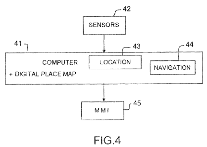
Figure 4 presents the variaus possible functionai blocks of a system
according tn the irrventi~n such as described previously. 1"he device
comprses acompifl:-;r 41 vv:,r:-, fc;r exarriEliP, at the !eve' of the user's
waist
and sensors 42. f.tistributec' o,rer t%re user's body. Each sensor 42 can
represent a set of sensors ct:^tral',zed at a particu'a.r spot on the body.
The computer 41 can be lirt":ed .:;y a bidirectional link to an HMl 45
intended
notably for entering irrput da`;;, part:cul:tr for inputting til;e departure
point
and the arrival point, as vjell as fc:r inputting interriiediate markers for
examPle. 7he HMI ;s for exarnt:Es>k also intenc+ed for presenting information
as
output fron-, :he c;oropilr't: rA i--i:ch as ricitab'y inca;c.ation::
regarding the
planried route, ciist.,.=,,ce-i ::) ef .-iireci:;c-n,. This information can be
. . . ' . . . - s .. . .
. ... . ..... . . _ ,... . , . . . ..
. . . _ . , . . . . .
. , . ' . . ' .. . - _ .. . _ . . .:._.-. . , . .- , . . . . _ . _ ._ . .. . f
delivered in audible, visual o< fac=ife form.
The computer comprises in memory a 2D or 3D digital mappin; of places, in
which the user's movements are p.lannea.
The computer moreover (-omprises in memory the location
software comprising a system for processing the signals originating from the
sensors 42, and from the H;`=Jil, as well as for example a computerized system
which performs thE fusion o- the ;'ata between the mapping and the
information arising from the sensors and from the HMI, this system
calculating on the basis of thes.e data the user's instantaneous absolute
location, that is to say the user's positior referenced with respect to the
map.
It can also comprise for example a navigation software 44 performing the
planning of the route to be traveled on the basis cf the arrival point and of
the
user's position referenced with resc;ect to 1:he map.
The sensors 42 are iinked t,~ the computer.
These sensors 42 car, be inertial units. an inertiai unit i.,eina able in this
case
to be the associa;ior, of 3 g, rrn:eters and 3 au-celerometerP-:. These
inertial
units give acceleration and relkation speed information, but not position
information. 1"3ie .sNstern mus; '.iT::refore de'ermirie the user's position
on the
basis of the data f`iOvideci ID'`f these s:~"":,ors. iaevice ::an moreover
comprise other types o~f szr,sors si.ich as a barometer and/or a
magnetorneter, these senst~)rs being situated for example in the same
housing as tr+at which cornovises trie corfti}Ealer.
To define the position ot the user, ~:irn; ta integration o~ the speeds and
accelerai:ons given by the s=,n-c7rs is r.o~' sufficient since the ;osition
thus
calculated drs~ts rapidly. The sys;em there,ore makes it possible to regularly
realign tne calcuiate:i position c f'Ohe user. For this purpose, tf le system
uses
for example:
- the sic,tature of signai-_: r,r ieac,":irIg tFhe key po:rats o~ fihe path
such as
for exdmpie staircases or ~= ;,harige of direction;
- the information given by i`;e use,-, for example when reaching the
barriers oi' the sabv!-Rv; o~
- the cietection of strides.
An HMi can be useu to e<<'L~~;r inx7>.i? data ar,-: to ~,.esert information at
output.
This HNtt cari use serfso,~= ->iqnais, fo.r ox,ampl e at-idible or tactile
and/or
CA 02693035 2010-01-12
CA 02693035 2010-01-12
~
visual. The interface., &osnn fcr examplrr so as to comply with rules which
may be important such as not masking, aitering or disturbing audible, haptic,
olfactory or therr, a! indices~ custornarily exploited by users. The HMI must
moreover preferably corr, ;'t,.anicate only what is useful at the opportune
moment without genErating errors or !oWersrirt the levei of vigilance.
As regards the mapping of p1:;c~ws, ;;D pians of the subway for example
already exist and the plans of p"blic p'aces or buildings are relatively
simple
to produce in 3D, or in 21'j if orie limits Gnleself to movements on a single
floor.
For the navigation operations, standar-d algorithms can be used.
The invention advantaaeous!y makes it possible to perform the integration in
one and the same device of a set of variab!es originating from sensors, from
the user and from a prerecorded rnappinq. and uses the fusion of data arising
from the sensors and detai's qiveõ by the ;.iser W~i-`h the mappirg. The
fusion
of the data arisinc from the se?:sors is fc;r exarnp!e performed continually.
The location and navigatio; ~ software embedded in the system takes account
of the information arising from the sensors, the information given by the user
and the rrtappinq ir~tr; rr~ tic: ,. arc' on the oasis of tlhis +nformation it
delivers
the infori;zaiiun fur 'Li-te route tc ot J!
Advantageously, a device accaiding tU dhF: invEr;tion does not require any
complemerrtciry equij.;+n1 fer ti f! ir tl'f; t)E.fil(liiigs frave('s}.'.C,.
It is f;iol-eover discreet,
easy to vvear arlc; !i ;htwc:ight. is O*daotabie _o Gil the places mapped
beforehand. !t L;ses rniniaturi-":eo ai -id 'sc:vv-cost sensors. It is
particularly
adapted for partially-sighiad pe, s:;ns but i1 can also be used by able-bodied
persons.