Note: Descriptions are shown in the official language in which they were submitted.
CA 02693702 2010-01-12
WO 2009/017993
PCT/US2008/070575
METHOD FOR DETERMINING SEISMIC DATA QUALITY
BACKGROUND OF THE INVENTION
This invention relates to seismic exploration and processing, and more
specifically to determining the seismic data quality for a plurality of
locations in a given
seismic survey.
In the petroleum industry, seismic prospecting techniques are commonly used to
aid in the search for and the evaluation of subterranean hydrocarbon deposits.
In
seismic prospecting, one or more sources of seismic energy emit waves into a
subsurface region of interest, such as a geologic formation. These waves enter
the
formation and may be scattered, e.g., by reflection or refraction, by
subsurface seismic
reflectors (i.e., interfaces between underground formations having different
elastic
properties). The reflected signals are sampled or measured by one or more
receivers,
and the resultant data is recorded. The recorded samples may be referred to as
seismic
data or a "seismic trace". The seismic data may be analyzed to extract details
of the
structure and properties of the subsurface region of the earth being explored.
Seismic prospecting consists of three separate stages: data acquisition, data
processing and data interpretation. The success of a seismic prospecting
operation
depends on satisfactory completion of all three stages.
In general, the purpose of seismic exploration is to map or image a portion of
the subsurface of the earth (a formation) by transmitting energy down into the
ground
and recording the "reflections" or "echoes" that return from the rock layers
below. The
energy transmitted into the formation is typically sound energy. The downward-
propagating sound energy may originate from various sources, such as
explosions or
seismic vibrations on land, or air guns in marine environments. Seismic
exploration
typically uses one or more energy sources and typically a large number of
sensors or
detectors. The sensors that may be used to detect the returning seismic energy
are
usually geophones (land surveys) or hydrophones (marine surveys).
- 1 -
CA 02693702 2014-12-04
One example of a seismic survey that is used in the art is three-dimensional
("3D") seismic exploration. In 3D seismic exploration survey lines and seismic
arrays
are closely spaced to provide detailed subsurface coverage. With this high
density
coverage, extremely large volumes of digital data need to be recorded, stored
and
processed before final interpretations can be made. Processing requires
extensive
computer resources and complex software to enhance the signal received from
the
subsurface and to mute accompanying noise which masks the signal.
After the data is processed, scientists and engineers assemble and interpret
the
3D seismic information in the form of a 3D data cube which represents a
display of
subsurface features. Using this data cube, information can be displayed in
various
forms. Horizontal time slice maps can be made at selected depths. Using a
computer
workstation, an interpreter can also slice through the data cube to
investigate reservoir
issues at different seismic horizons. Vertical slices or cross-sections can
also be made
in any direction using seismic or well data. Seismic picks of reflectors can
be
contoured, thereby generating a time horizon map. Time horizon maps can be
converted to depth to provide a true scale structural interpretation at a
specific level.
Seismic data is generally acquired and processed for the purpose of imaging
seismic reflections for structural and stratigraphic interpretation. The
quality of the
seismic data that is ultimately used in the structural arid stratigraphie
interpretation
depends on many different factors and varies from survey to survey. Steps that
are
omitted or not correctly completed in the data acquisition, data process and
data
interpretation stages can greatly affect the quality of the final images or
numerical
representation of the subsurface features. The quality of the seismic data
directly
affects the reliability of observations and numerical measurements made from
the
seismic data and affects the decisions that can or should be based on the
seismic data.
Constructing accurate seismic images and corresponding earth models is
important in making business or operational decisions relating to oil and gas
exploration
and reservoir management. For example, earth scientists use seismic images to
determine where to place wells in subterranean regions containing hydrocarbon
reservoirs. They also build models of the subsurface to create reservoir
models suitable
- 2 -
CA 02693702 2010-01-12
WO 2009/017993
PCT/US2008/070575
for reservoir fluid flow modeling. The quality of the business and operational
decisions
is highly dependent on the quality of the seismic images and earth models.
As described above, determining the quality of the seismic data used in
seismic
images and earth models is important. Prior art methodologies for determining
seismic
data quality generate only a single value for data quality for an entire
seismic survey.
Seismic data quality is not measured and the spatial variability of seismic
quality within
a particular survey is ignored. Prior art methodologies do not take into
account that the
quality of the seismic data may vary at differing points in a single seismic
survey.
Thus, one particular location in a seismic survey may have poor seismic data
quality
while another location in the same survey may have relatively good seismic
data
quality. The prior art does not differentiate between locations within a
seismic survey
based on seismic data quality. Thus, when seismic property estimates are
combined
with well data, a global correlation coefficient is used, and no account is
given to the
spatial variability of the quality of the seismic data.
Determining where the high or the low quality seismic data resides within a
given seismic survey is important when decisions relating to oil and gas
exploration and
reservoir management are based in large part on seismic data.
There is a need for a method which determines the seismic data quality for a
plurality of locations in a given seismic survey.
SUMMARY OF THE INVENTION
The present invention overcomes the above-described and other shortcomings
of the prior art by providing a method of determining seismic data quality for
a plurality
of locations within a given seismic survey.
One embodiment of the present invention includes a method for measuring
seismic data quality which includes acquiring pre-stack seismic data for a
seismic
survey for an area of interest, and comparing predicted attributes to related
attributes
associated with the pre-stack seismic data to generate data quality
measurements for
- 3 -
CA 02693702 2010-01-12
WO 2009/017993
PCT/US2008/070575
each of a plurality of locations within the seismic survey. The predicted
attributes are
geophysically constrained so that they may be accurately forecasted. The
method
further includes displaying the data quality measurements to a user to
illustrate
differences in seismic data quality for the plurality of locations within the
seismic
survey.
It should be appreciated that the data quality measurements generated by the
present invention can be utilized in a variety of ways. For example, one
embodiment
of the present invention additionally includes acquiring well logs related to
the area of
interest, and computing well-tie measurements for the well logs to the pre-
stack
seismic data. The data quality measurements are compared with the well-tie
measurements to generate a plurality of correlation coefficients used in
geostatistical
models. One use of the geostatistical models is to determine P90, P50 and P10
values
that are associated with the analysis preformed on the seismic data.
Another embodiment of the present invention further includes degrading the
well log data and computing well tie measurements for the degraded well log
data,
and comparing the data quality measurements with the well tie measurements for
the
degraded well log data to generate a plurality of correlation coefficients to
be used in
geostatistical models.
It should be appreciated that the predicted geophysical attributes and the
geophysical attributes associated with the pre-stack seismic data which are
used to determine seismic data quality include seismic amplitude and angle of
incidence or seismic amplitude and offset (distance between source and
receiver).
It should also be appreciated that by determining the area in which the
seismic
data quality is low further analysis can be performed to determine the
cause(s) of the
low seismic data quality. Examples of such causes which are well-known in the
art
are multiples, residual moveout, anisotropy, random noise and coherent noise.
- 4 -
CA 02693702 2016-07-25
Oil and gas exploration arid reservoir management plans also benefit from the
present invention. Plans can be adjusted or based on areas of high seismic
data quality.
For example, delineation and production wells can be drilled in locations with
the best
quality seismic data available. The wells will then be drilled with a high
degree of certainty that the predicted stratigraphy will be accurate. This can
be
especially true for the initial wells that are being drilled in areas where
there is little or
no well log data.
A significant fraction of the value of a well is that it provides hard data on
the
geology of the subsurface, and in particular, the reservoir in the localized
region of the
well. If wells are drilled in areas of poor or marginal data quality, there
will be poor
well-to-seismic ties, i.e. tying well properties to seismic after the well has
been drilled.
Poor well-to-seismic ties are a severe limitation on the estimation of
reservoir properties
from seismic data. Well-to-seismic ties are a direct primary input into
reservoir property workflows. Poor well-to-seismic ties are significant
factors in poor
seismic seismic estimation of lateral changes in lithology and/or porosity.
It should also be appreciated that the present invention is intended to be
used
with a system which includes, in general, an electronic configuration
including at least
one processor, at least one memory device for storing program code or other
data, a
video monitor or other display device (i.e., a liquid crystal display) and at
least one input
device. The processor is preferably a microprocessor or microcontroller-based
platform
which is capable of displaying images and processing complex mathematical
algorithms. The memory device can include random access memory (RAM) for
storing
event or other data generated or used during a particular process associated
with the
present invention. The memory device can also include read only memory (ROM)
for
storing the program code for the controls and processes of the present
invention.
In an aspect, there is provided a method of measuring seismic data quality,
comprising: acquiring pre-stack seismic data for a seismic survey for an area
of
interest; comparing predicted attributes to related attributes associated with
the pre-
stack seismic data to generate data quality measurements for each of a
plurality of
locations within the seismic survey, wherein the predicted attributes are
geophysically or geologically constrained; and displaying the data quality
measurements to a user to illustrate differences in seismic data quality for
the
-5-
CA 02693702 2016-07-25
plurality of locations within the seismic survey, wherein the seismic data
quality is
a measure of the seismic data reliability.
Additional features and advantages of the present invention are described in,
and will be apparent from, the following Detailed Description of the Invention
and the
Figures.
-5a-
CA 02693702 2010-01-12
WO 2009/017993 PCT/US2008/070575
BRIEF DESCRIPTION OF THE DRAWINGS
These and other objects, features and advantages of the present invention will
become better understood with regard to the following description, pending
claims
and accompanying drawings where:
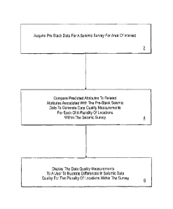
Fig. 1 illustrates a flow chart of one embodiment of the present invention;
Fig. 2 illustrates one embodiment of the present invention utilized in a
workflow for reservoir management;
Fig. 3 illustrates one embodiment of the present invention utilized in a
workflow for exploration/appraisal;
Fig. 4 illustrates a graph of seismic amplitude and angle of incidence which
is
used by one embodiment of the present invention to determine seismic data
quality;
Fig. 5 illustrates an image of a seismic survey;
Fig. 6 illustrates the seismic survey shown in Fig. 5 wherein one embodiment
of the present invention determined the seismic data quality for a plurality
of locations
throughout the seismic survey;
Fig. 7 illustrates the seismic survey shown in Fig. 6 with full angle stacks
included in the image;
Fig. 8 illustrates an input gather, predicted gather and residual (subtraction
of
the predicted gather from the input gather) generated by one embodiment of the
present invention for a location selected on the seismic survey shown in Fig.
7;
Fig. 9 illustrates the seismic survey shown in Fig. 7 with two selected
locations;
-6 -
CA 02693702 2010-01-12
WO 2009/017993
PCT/US2008/070575
Fig. 10 illustrates an input gather, predicted gather and residual generated
by
one embodiment of the present invention for the two selected locations
included in the
seismic survey shown in Fig. 9;
Fig. 11 illustrates a workflow of one embodiment of the present invention
wherein the seismic data quality is utilized to perform geostatistical
interpolation of
well data and reservoir properties estimated from seismic;
Fig. 12 illustrates a graph which is used by one embodiment of the present
invention to determine correlation coefficients; and
Fig. 13 illustrates a map view of a geological region of interest wherein one
embodiment of the present invention has determined the seismic data quality
for a
plurality of location included on the horizon.
- 7 -
CA 02693702 2010-01-12
WO 2009/017993
PCT/US2008/070575
DETAILED DESCRIPTION OF THE INVENTION
While this invention is susceptible to embodiments in many different forms,
there are shown in the drawings, and will herein be described in detail,
preferred
embodiments of the invention with the understanding that the present
disclosure is to
be considered as an exemplification of the principles of the invention and is
not
intended to limit the broad aspect of the invention to the embodiments
illustrated.
The present invention enables a user to make a novel determination of the
differences in the seismic quality of a plurality of locations within a
seismic survey.
One embodiment of the present invention is illustrated in Fig. 1. That
embodiment
includes a method for measuring seismic data quality which includes acquiring
pre-
stack data for a seismic survey for an area of interest 2. The embodiment
further
includes comparing predicted attributes to related attributes that are
associated with
the pre-stack data to generate data quality measurements for each of a
plurality of
locations within the seismic survey 4. In this embodiment the predicted
attributes
which are used are attributes that are geophysically constrained. With these
constraints, accurate predictions as to what the relationships between
attributes for a
particular subsurface location can be made. The embodiment also includes
displaying
the data quality measurements to a user to illustrate the differences in
seismic data
quality for the plurality of locations within the survey 6.
In the above-described embodiment, a scientist and engineer will be able to
ascertain areas within a seismic survey with relatively good seismic data
quality and
relatively poor seismic data quality. The present invention allows seismic
data quality
differences to be used in the reservoir management and the
exploration/appraisal
process to evaluate the confidence of the results generated by those
processes. For
example, Fig. 2 illustrates a workflow in a reservoir management process
wherein
seismic data 8 undergoes seismic inversion 1 0 and reservoir properties are
estimated,
such as porosity, facies and/or lithology 12. The estimated reservoir
properties are
then used to generate a reservoir model or models 14. The present invention
allows
seismic data quality 14 in this embodiment to be used during the reservoir
model
generation to determine the areas with relatively good and poor seismic data
quality.
- 8 -
CA 02693702 2010-01-12
WO 2009/017993
PCT/US2008/070575
With that knowledge, scientists and engineers can have a higher or lower
degree of
confidence in their observations and measurements depending on a particular
location
within the model(s) where the decision is being made on and the seismic data
quality
associated with that location.
Fig. 3 illustrates another embodiment of the present invention which is
utilized
in the exploration/appraisal process. In this embodiment, seismic attributes
20 are
derived from seismic data 18 acquired from a geological region of interest.
Examples
of seismic attributes 20 include envelope amplitude, instantaneous phase,
instantaneous frequency, polarity, velocity, dip, dip azimuth, etc. The
seismic
attributes 20 are compared to the geophysical attributes which have been
determined
from forward models of the geological region of interest 24. Utilizing
the
comparisons of the attributes from the seismic data and attributes from the
forward
models, final estimates of the attributes are determined and those attributes
are used to
determine characteristics of the geological region of interest and any
reservoirs
residing in that region of interest 26. One important characteristic which
results from
this type of analysis is inferring the fluid type present in the region of
interest, i.e.
brine, oil, or gas 26.
Prior art methodologies have calculated the overall uncertainty with the
result
or results of such analyses. This embodiment of the present invention
incorporates
seismic data quality 22 after the seismic attributes have been determined. In
this
manner the uncertainties can be more accurately predicted and that uncertainty
can be
tied to specific locations within the seismic survey.
The present invention allows for inconsistencies and causes of the low quality
seismic data to be identified and resolved at earlier stages of the process
which saves
valuable time and resources.
The embodiment illustrated in Fig. 1 includes comparing predicted attributes
to related attributes that are associated with the pre-stack seismic data to
generate data
quality measurements for a plurality of locations within the seismic survey 4.
The
compared attributes in that embodiment are geophysically constrained so that
the
- 9 -
CA 02693702 2010-01-12
WO 2009/017993
PCT/US2008/070575
attributes can be accurately predicted. Fig 4 illustrates one embodiment of
the present
invention which utilizes seismic amplitude 28 versus the angle of incidence 30
to
measure the seismic data quality of a particular location in a seismic survey.
The
relationship 32 between seismic amplitude 28 and angle of incidence 30 is
geophysically constrained. As the angle of incidence 30 increases, the seismic
amplitude 28 must change in a smoothly varying manner 32, Thus, this
embodiment
of the present invention utilizes that relationship 32 to determine seismic
data quality.
The predicted relationship between the two attributes 32 is compared to the
relationship between the attributes obtained from the seismic data 34. The
difference
between the two relationships 32, 34 is indicative of the seismic data quality
being
relatively high or low. One means of quantifying this difference is to compute
the
total length of the line segments comprising the measured data 34 and compare
this to
the total length of line segments comprising the predicted data 32. Thus, the
length of
the predicted relationship 32 and the length of the measured relationship 34
of the two
attributes can be used to determine a value for seismic data quality. One
embodiment
of the present invention utilizes the following mathematical expression to
generate a
seismic data quality value:
Quality= 1
P\
(Measured
Pr edicted )
wherein:
Quality = Seismic Data Quality;
Measured =Measured Relationship of Attributes (one example is the length of
line
segments 34 illustrated in Fig. 4);
Predicted = Predicted Relationship of Attributes (one example is the length of
line
segments 32 illustrated in Fig. 4); and
P = Mathematical Exponent.
An alternative embodiment of the present invention utilizes the following
mathematical expression to generate a seismic quality value:
- 10 -
CA 02693702 2010-01-12
WO 2009/017993
PCT/US2008/070575
Quality =( Predicted
Measured
Where Quality, Measured, Predicted and P are defined above. Utilizing the
relationship between the attributes that can be measured and predicted,
seismic data
quality can be determined.
The present invention determines the seismic data quality for a plurality of
locations with a seismic survey. The present invention enables images of
seismic data
quality to be viewed so that a user can determine areas of high and low
seismic data
quality within the seismic survey. For example, a cross-sectional post stack
image 40
of a seismic survey is illustrated in Fig. 5. The post stack image 40 includes
full angle
stacks 42, and a reservoir 44 has been identified within this geological
region. The
present invention enables seismic data quality to be incorporated into the
image for
further analysis as illustrated in Fig. 6. The areas which have relatively
high seismic
data quality 52 are distinguished from areas having low seismic data quality
50. Fig 7
is an image 54 of the same area of geological interest as Figs. 5 and 6 but
the full
angle stacks 42 have been included for additional delineation within the image
54.
The embodiment of the present invention illustrated in Figs. 5, 6 and 7
additionally includes the ability to identify a particular location 46 and to
analyze the
input gather 56 and a modeled (or predicted) gather 58 for that particular
location 46.
That embodiment is able to compare the input gather 56 with the modeled (or
predicted) gather 58 and display a residual 60 as illustrated in Fig. 8.
Focusing on the
chosen location 46, one can see that there is a relatively high amount of
residual 60
which indicates poor seismic data quality.
Fig. 9 illustrates the same geological region of interest 54 as Fig. 7,
however,
two different locations have been chosen. One location is in a region of poor
seismic
data quality 62, and the other location is chosen in a region of good seismic
data
quality 64. As the two locations 62, 64 are on the same vertical axis, the
locations can
be displayed on an input gather 66, modeled gather 68 and residual 70 as
illustrated in
- 11 -
CA 02693702 2010-01-12
WO 2009/017993 PCT/US2008/070575
Fig. 10. Comparing the location with poor seismic data quality 62 and the
location
with high seismic data quality 64, the location with poor seismic data quality
62 has
more residual 70 that the location with high seismic data quality 64.
The present invention allows for a variety of methodologies of determining the
seismic data quality for a seismic survey and those methodologies are intended
to be
within the scope of the present invention. For example, one embodiment of the
present invention utilizes an interactive program to allow the selection and
viewing of
gathers. That embodiment allows the user to select a seismic quality vertical
slice
from a seismic survey and display the input gather, modeled gather and the
residual
for that slice. Another embodiment of the present invention processes all or a
portion
of the data acquired from an entire 3D seismic survey.
The seismic data quality can also be utilized in geostatistical models which
are
used to calculate P90, P50 and P10 values associated with decisions which are
based
on the seismic survey. One embodiment of the present invention determines the
seismic data quality for a plurality of locations within a seismic survey, and
further
includes transforming the seismic data quality measurements into correlation
coefficients. This numerical transformation is achieved by deriving a
mathematical
relationship between seismic quality and well-tie correlation coefficient.
Well-ties
refer to a comparison of actual seismic traces to synthetic seismic traces
computed
using well log data. The
functional relationship between seismic quality and
correlation coefficient is found by plotting values of seismic quality and
correlation
coefficient at well locations. The functional relationship is used to convert
the
seismic quality measurements into correlation coefficients. Measurements of
seismic
quality, converted to measurements of correlation coefficient, are used to
control how
seismic estimates of reservoir properties are combined with well data in the
building
of reservoir models.
One embodiment of the present invention includes acquiring pre-stack seismic
data 72, computing the seismic data quality 74 and converting the seismic data
quality
values to correlation coefficients to generate a calibrated quality cube 76 as
illustrated
in Fig. 11. The calibrated quality cube 76 is then used in geostatistical
interpolation
- 12 -
CA 02693702 2010-01-12
WO 2009/017993
PCT/US2008/070575
80. Prior art methods have been limited to generating a single correlation
coefficient
for an entire seismic survey. The correlation coefficient controls how the
seismic
estimates of reservoir properties are spatially combined (interpolated) with
well data.
The present invention enables more detailed and accurate geostatistical
determinations by utilizing seismic data quality associated with a particular
location
within a seismic survey.
The embodiment of the present invention illustrated in Fig. 11 uses well-ties
to
generate correlation coefficients which are then utilized in a geostatistical
analysis.
This embodiment additionally degrades the seismic data so that additional well-
tie
measurements can be generated to augment existing well-tie data. Pre-stack
seismic
data 72 at locations where there is also well data is collected. That pre-
stack seismic
data 72 is then degraded by adding in residual moveout, random noise and
multiples
82 in this embodiment. Angle stacks are formed using the degraded and original
pre-
stack data obtained from the well locations 84. Well-tie measurements are
computed
82, and correlation coefficients for the well-tie measurements are determined.
The
well-tie measurements are used to establish a relationship 88 between
correlation
coefficients and seismic data quality as shown in the graph illustrated in
Fig. 12.
Once the relationship 88 between the correlation coefficients and the seismic
data
quality has been established, correlation coefficients can be determined for
locations
that do not have well-tie measurements available. All that is needed for
locations
where there is no well data is seismic data quality values. With the seismic
data
quality values, correlation coefficients can be determined regardless of
whether well
data is available. In this manner, geostatistical interpolation can be
performed at
multiple locations throughout a seismic survey.
As described-above, the present invention provides valuable information that
can be used during reservoir management and exploration/appraisal decision-
making.
Fig. 13 illustrates a map view 90 of a horizon within a geological region of
interest
generated by the present invention. Decisions have to be made on where to
drill
delineation and production wells. In this particular example, it has been
determined
that a certain area 92 within this region of interest 90 includes a sand layer
which
potentially bears natural gas. The area 92 is then further narrowed as to the
optimal
- 13 -
CA 02693702 2010-01-12
WO 2009/017993
PCT/US2008/070575
locale 94 for drilling a well. As with most plans, there is spatial
flexibility as to the
exact location of well placement. Within the locale 94 shown in Fig. 13 there
are
areas which have good seismic data quality and bad seismic data quality. In
this
example, the decision can be made to place the well in an area with good
seismic data
quality 96. Placing the well in the area with good seismic data quality
increases the
certainty that stratigraphic predictions will be accurate and spatial
interpolation of
results will be possible.
While in the foregoing specification this invention has been described in
relation
to certain preferred embodiments thereof, and many details have been set forth
for
purpose of illustration, it will be apparent to those skilled in the art that
the invention is
susceptible to alteration and that certain other details described herein can
vary
considerably without departing from the basic principles of the invention.
- 14 -