Note: Descriptions are shown in the official language in which they were submitted.
CA 02694020 2010-01-21
WO 2008/145986 PCT/GB2008/001805
-1-
GLOBAL POSITIONING SYSTEM ERROR CORRECTION,
VEHICLE TRACKING AND OBJECT LOCATION
The present invention relates to a method of correcting errors in determining
the
location of a GPS receiver and to a method for tracking vehicles using a GPS
receiver and relates particularly, but not exclusively, to such methods using
mobile
telephone networks to receive and disseminate such data. The invention also
relates to a method and apparatus for locating an object.
The use of global positioning system (GPS) devices to determine the location
of
the device is well known. GPS uses signals transmitted from satellites to
triangulate and determine a position that the signals were received. This is
done
by determining the distance that a signal has travelled from the satellite _to
the
GPS receiver, the distance being determined from the time that the signal has
taken to travel multiplied by the speed of light. However, the speed of light
is only
constant within a vacuum and therefore as the GPS signal passes through the
ionosphere and troposphere it changes its path bouncing off ice and charged
particles. These errors mean that a standard GPS receiver can determine its
position to within around ten metres.
In order to overcome this problem an error correction service, known as
differential
global positioning system (DGPS), uses a series of GPS reference stations at
fixed known locations. The exact position of these locations is known and
therefore the difference between the calculated position, by a GPS receiver at
that
location, can be determined. This error factor is then transmitted to DGPS
receivers that can then use this error factor to improve their estimation of
their
present location. DGPS typically has an accuracy of around four metres.
However, building and installing reference stations is expensive and in the UK
they
are located approximately every 200 kilometres. As a result, such DGPS
stations
are unable to accommodate local inaccuracies. For example, GPS signals
bouncing off tall buildings can cause significant errors in built up areas
where it is
also often the case that roads can be separated by very short distances
leading to
CONFIRMATION COPY
CA 02694020 2010-01-21
WO 2008/145986 PCT/GB2008/001805
-2-
a GPS receiver indicating that it is located at a position on a different road
than it is
really located.
Where GPS receivers are used in conjunction with a mobile phone network
transmitter, typically a general packet radio service (GPRS) transmitter, to
track
vehicles, a large amount of data relating to the position, direction of travel
and
speed of travel of a vehicle are transmitted to a tracking station, typically
by SMS
message. Because of the low frequency with which the information is sent it is
difficult to build up an accurate picture of the movement of the vehicle or to
determine patterns in driving and in driver technique.
Preferred embodiments of the present invention seek to overcome the above
defined problems with the prior art.
According to an aspect of the present invention there is provided a method of
determining an error factor for a differential global positioning system,
comprising
the steps of:-
receiving data transmitted from at least one device travelling along at least
one of
a plurality of known routes, the data relating to a plurality of assumed
positions of
the device on the basis of global positioning system signals received by
global
positioning system receiver in said device;
comparing a plurality of said assumed positions of the device with said
plurality of
routes to determine the route that most closely corresponds with the plurality
of
assumed positions; and
comparing a plurality of said assumed positions with the determined route to
calculate an error factor.
By receiving a plurality of assumed positions transmitted from a device
including a
GPS receiver, matching these to a known route and determining an error factor,
CA 02694020 2010-01-21
WO 2008/145986 PCT/GB2008/001805
-3-
the advantage is provided that the error factor can be determined more
accurately,
than in the devices of the prior art, and can take into account local factors
that
affect the accuracy of the GPS reading. For example, the device of the present
invention can eliminate localised weather factors, that have small but not
insignificant impact on the accuracy of the GPS measurement that is not
possible
with fixed stations as widely spread as in the prior art. Furthermore,
localised
factors such as reflection of GPS signals on tall buildings are also
accommodated
and the introduction of new structures is immediately accommodated as soon as
data from a device using the method of the present invention passes by that
building. Also combinations of these factors are accommodated to increase the
accuracy.
The method may further comprise transmitting said error factor to differential
global positioning system devices.
By transmitting this data to DGPS devices, these devices are able to provide
very
accurate GPS readings up to an accuracy of 50 centimetres.
The method may also further comprise transmitting at least one of said data
and
said error factor via a mobile telephone network.
By using a mobile telephone network to transmit the error factor, the
advantage is
provided that very extensive coverage is already provided by the telephone
network thereby allowing the increase in accuracy to be equally widely
available.
Furthermore, since GPS devices are often used in tracking vehicles then data
is
already being transmitted to and from the receiver device. Furthermore, if a
vehicle is being tracked it is possible to provide a very localised error
factor
thereby taking into account the local conditions. For example, if a large
building
causes significantly different factors then as a vehicle approaches this
building the
error factor can be altered dynamically according to the vehicle's location.
In a preferred embodiment the error factor is expressed as a vector.
CA 02694020 2010-01-21
WO 2008/145986 PCT/GB2008/001805
-4-
The method may further comprising:-
causing said device to travel along at least one of a plurality of known
routes; and
transmitting data relating to a plurality of assumed positions of the device
on the
basis of global positioning system signals received by said global positioning
system receiver in said device.
The method may also further comprise storing data relating to said position of
said
device at known intervals and said transmitted data excludes data relating to
the
speed and direction that the device is travelling.
By collecting and transmitting only positional data at regular intervals, the
advantage is provided that only a small amount of data is produced by each
vehicle that is being used to determine the GPS error factor. As a result,
since it is
desirable to use as many vehicles as possible to determine the accuracy over
as
large an area as possible, the amount of data produced, and therefore
transmitting
band width and processing resource required is not excessive.
According to another aspect of the present invention there is provided a
computer
program for determining an error factor for a differential global positioning
system,
the program comprising:-
first computer code for receiving data transmitted from at least one device
travelling along at least one of a plurality of known routes, the data
relating to a
plurality of assumed positions of the device on the basis of global
positioning
system signals received by global positioning system receiver in said device;
second computer code for comparing a plurality of said assumed positions of
the
device with said plurality of routes to determine the route that most closely
corresponds with the plurality of assumed positions; and
CA 02694020 2010-01-21
WO 2008/145986 PCT/GB2008/001805
-5-
third computer code for comparing a plurality of said assumed positions with
the
determined route to calculate an error factor.
The computer program may further comprise fourth computer code for
transmitting
said error factor to differential global positioning system devices.
The computer program may also further comprising fifth computer code for
transmitting at least one of said data and said error factor via a mobile
telephone
network.
In a preferred embodiment said third computer code calculates the error factor
as
a vector.
According to another aspect of the present invention there is provided a
method of
tracking a global positioning system receiving device, comprising the steps
of:-
receiving a plurality of global positioning system signals relating to a
position of
said device;
storing data relating to said position of said device at known intervals in
time; and
transmitting said data relating to said position of said device, said
transmission
including Cartesian coordinates indicating said position and excluding data
relating
to the speed and direction that the device is travelling or including vector
coordinates indicating said position relative to a previous position and
excluding
Cartesian coordinates indicating said position.
By tracking a vehicle using very small amounts of data, only relating to the
position
of the vehicle containing the GPS receiver the advantage is provided that the
reduced information that is sent is cheaper to transmit and yet can provide
more
information, upon analysis, than tracking systems of the prior art. For
example,
the position data can be used to accurately trace a position of the vehicle on
a
CA 02694020 2010-01-21
WO 2008/145986 PCT/GB2008/001805
-6-
road. Since the data is recorded at known time intervals, it is easy to
calculate the
vehicle's speed thereby determining if speed limits have been broken.
Furthermore, statistical information about driving style can be derived, for
example
showing rapid acceleration and deceleration of the vehicle. Using an apparatus
of
the present invention a vehicle travelling eight hours per day produces
typically
only 3Mb of data in one month which is significantly less than seen in the
prior art.
In a preferred embodiment the intervals are intervals in time.
In another preferred embodiment the intervals are determined dependent upon
the
distance travelled from the last stored position relative to the speed.
In a further preferred embodiment the intervals are determined such that data
is
stored when the distance from the last stored position measured in metres is
equal
to or greater than the speed measured in miles per hour.
By storing, and then transmitting data whenever the distance from the last
point,
measured in metres, is equal to or greater than the present speed, the data
that is
received by the server is very easily analysed. For example, the processing
required to determine the speed at which a vehicle is travelling is
significantly
reduced since this is simply determined by measuring the distance between two
adjacent points and that distance in metres is the speed in miles per hour
that the
vehicle was travelling at the second data point. Furthermore when a vehicle is
travelling at a constant speed the data points are equidistant with respect to
time,
upon deceleration the points are closer together and upon acceleration they
are
further apart. It is therefore possible to derive a large amount of
information from a
small amount of data transmitted. However, the format that is used to transmit
the
data allows additional information to be easily derived without the server
having to
process large amounts of data which could put a significant strain on system
resources when a large number of vehicles are being tracked.
In a preferred embodiment the data is transmitted via a mobile telephone
network.
CA 02694020 2010-01-21
WO 2008/145986 PCT/GB2008/001805
-7-
In another preferred embodiment the global positioning system receiving device
is
a differential global positioning system receiving device.
In a further preferred embodiment the differential global positioning system
receiving device uses an error factor determined according to the method
defined
above.
According to a further aspect of the present invention, there is provided a
first
device for indicating the direction to at least one second device, the first
device
comprising:
a receiver for receiving information relating to the location of a second
device;
location determining means for determining the location of the first device;
calculating means for calculating the direction from the first device to the
second device; and
indication means for indicating said direction.
By providing a user of the first device with a means for indicating the
direction to a
second device, provides the advantage of the user of the first device being
able to
easily locate the second device. For example, in the situation of two people
trying
to locate each other in a city centre, if each of them has a device according
to the
above invention then they will easily be able to find each other.
In a preferred embodiment the first device further comprises a transmitter for
transmitting information relating to the location of the first device.
In another preferred embodiment the transmitter and the receiver comprise a
single unit.
In a further preferred embodiment the indication means comprises at least one
screen displaying an arrow which points in the direction of the second device.
CA 02694020 2010-01-21
WO 2008/145986 PCT/GB2008/001805
-8-
In a preferred embodiment the indication means further indicates the distance
between the first and the second devices.
In another preferred embodiment the first device is a mobile communication
device.
In a further preferred embodiment the location determining means comprises a
global positioning system.
In a preferred embodiment the global positioning system is a differential
global
positioning system.
In another preferred embodiment the differential global positioning system
uses an
error factor determined according to the method set out above.
This allows a user of a device of the present invention to locate another
device to
within 50cm. It also improves the ease of use of the device. In a standard GPS
unit, unless it is provided with an internal compass, the direction of travel
can be
determined when the device is moving but then when it is stationary the
direction
the device is pointing cannot. Therefore with a standard GPS it is necessary
to
move around 10m before the device can determine the direction of travel and
point
in the direction of the second device. However, by using the increased
accuracy of
the present invention only a small movement of 50 cm is necessary.
In a further preferred embodiment the differential global positioning system
uses
an error factor determined using a computer program as set out above.
In a preferred embodiment the first device comprising the global positioning
system is tracked according to the method set out above.
In another preferred embodiment the first device comprising the differential
global
positioning system is tracked according to the method set out above.
CA 02694020 2010-01-21
WO 2008/145986 PCT/GB2008/001805
-9-
According to aspect of the present invention there is provided a method of
indicating the direction from a first device to at least one second device,
the
method comprising the steps of:
a first device receiving information relating to the location of a second
device;
determining the location of the first device;
calculating the direction from the first device to the second device; and
indicating the direction.
The method may also comprise the step of the first device transmitting
information
relating to the location of the first device.
The method may further comprise the step of the first device receiving
information
from the second device.
The method may also comprise the step of the first device receiving
information
from at least one fixed GPRS transmitter/receiver.
The method may further comprise the step of the first device transmitting
information to the second device.
The method may also comprise the step of the first device transmitting
information
to at least one fixed GPRS transmitter/receiver.
The method may further comprise the step of the first device receiving
information
for every 0.5 meters of movement of the first device.
The method may also comprise the step of the first device transmitting
information
for every 0.5 meters of movement of the first device.
CA 02694020 2010-01-21
WO 2008/145986 PCT/GB2008/001805
-10-
Preferred embodiment of the present invention will now be described, by way of
example only, and not in any limitative sense, with reference to the
accompanying
drawings in which:-
Figure 1 is a schematic representation of apparatus used in the present
invention;
Figure 2 is a flow chart showing the steps of the present invention;
Figure 3 is a schematic representation of the method of collecting data used
in the
present invention;
Figure 4 is a schematic representation of the determination of the error
correction
factor used in the present invention;
Figure 5 is a schematic representation of the determination of the route being
taken as used in the present invention; and
Figure 6 is a schematic representation of an apparatus of a further aspect of
the
present invention.
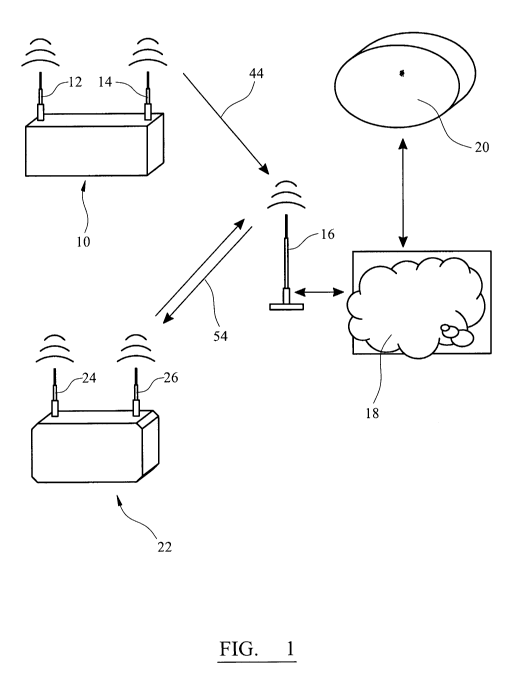
Referring to figure 1, the apparatus used in the method of the present
invention
can utilise known apparatus as follows. A mobile sensing unit 10 includes a
GPS
receiver 12 that receives a GPS signal to estimate the location of the mobile
sensing unit 10. The unit 10 also includes a GPRS transmitter that transmits
data
to a fixed GPRS transmitter/receiver 16. The GPRS transmitter 14 of mobile
sensing unit 10 can typically also act as a receiver, although in the example
shown
in figure 1, only the transmitting function is required in order to operate
the method
of the present invention. The data received by the fixed GPRS
transmitter/receiver
16 is transmitted, via the internet 18, to a processor/server 20, which is
used to
calculate an error correction factor.
CA 02694020 2010-01-21
WO 2008/145986 PCT/GB2008/001805
-11-
Upon instruction from processor/server 20, via internet 18, the fixed GPRS
transmitter 16 transmits the correction factor data to a differential GPS 22.
The
differential GPS 22 has a GPS receiver 24 (equivalent to the GPS receiver 12
of
mobile sensing units 10) and a GPRS receiver 26. In the example shown in
figure
1, the GPRS receiver 26 is also able to act as a transmitter to transmit data
to the
processor/server 20 via fixed GPRS transmitter/receiver 16 and internet 18.
This
transmitting function from differential GPS 22 is only required for
embodiments
that are tracking the movement of differential GPS 22.
In the method of the present invention, a vehicle 28, that has mounted on
board a
mobile sensing unit 10, travels along road 30 following a route 32 (step 34).
Since
the position of the mobile sensing unit 10 is fixed within vehicle 28 the
position of
route 32 within the width of road 30 is known to an accuracy of less than 50
centimetres. The GPS receiver 12 receives GPS signals (step 36) and is able to
estimate its position at a plurality of positions 38 using standard GPS
techniques (step 40). Due to variations in the speed of light as it travels
through
the earth's atmosphere and due to localised factors such as building, these
positions are only estimated to an accuracy of +/- 10 metres. These estimated
positions 38 are temporarily stored in the mobile sensing unit before the data
is
transmitted using GPRS transmitter 14 (step 44). The estimated position is
temporarily stored as a point in space (latitude, longitude and height) and
these
co-ordinate points are either transmitted as a single point (three numbers),
and
deleted from the temporary memory, or transmitted as a series of data points.
The
estimated position data is received by fixed GPRS transmitter/receiver 16 and
passed to processor/server 20 via the internet 18.
In its simplest form the estimated position data 38 can be transmitted as
simply a
point in space without any additional information, such as the time of
transmittal,
the direction or speed of travel of the vehicle 28. The time at which the
location is
estimated does not need to be accurately provided as it can be estimated as
approximately the time at which it is received by server 20 since this is
sufficient
for the purposes of estimating the GPS error factor.
CA 02694020 2010-01-21
WO 2008/145986 PCT/GB2008/001805
-12-
When the estimated position data is received at server 20 (step 46) the
estimated
positions are compared with known routes (the locations of roads 30) to
determine
which road the vehicle 28 has been travelling along. This is a reasonably
straightforward process since the estimated locations are accurate to around
+/-10
metres and when a series of data points are grouped together it is readily
apparent
which road a vehicle has travelled along. Referring to Figure 5, a first GPS
estimated position 60 could be any one of the points on the road 32 contained
within the ring 62. That is all of those points are within an expected error
range
(typically 10m) of the first estimated point 60. When a second estimated point
64
is received by the server, it is clear that the vehicle is travelling in the
direction
indicated by arrow 66. It can therefore be assumed that the vehicle is
travelling on
the left hand side of the road (if in the UK or other left hand drive
countries).
Information relating to the direction of travel in a particular lane is held
by the
server. As a result point 64 must be one of the points contained in the ring
68, that
is those on the left hand side of the road within 10m of point 64. Similarly
the third
estimated point 70 could be any of the points contained within ring 72 because
the
vehicle is travelling a direction indicated by arrow 74 that is approximately
the
same as indicated by arrow 66. It is possible from this first three estimated
data
points to determine that the actual location of the vehicle is to the right of
the
estimated data point but it is not clear which of the point on the road
contained
within ring 72 is the actual location. Because the arrows 66 and 74 point in
approximately the same direction, the points on the road contained within the
rings
62, 68 and 72 are approximately linear. However, because the fourth estimated
point has shifted to right, out of line with the other estimated points, and
the shape
of the left hand side of the road turns a corner this means that, since the
distance
that the estimated data point is from the actual position on the road is in
all
likelihood the same, the only point one the road 32 that is to the left of the
fourth
estimated point 76 and is at a similar distance as the data points in rings 68
and
72, is the point in ring 78. It is therefore possible to make an initial
estimate of the
error vector as the direction indicated by arrow 80 and the distance between
points
76 and 78.
CA 02694020 2010-01-21
WO 2008/145986 PCT/GB2008/001805
-13-
Alternatively this process can be viewed as initially calculating the error by
simply
subtracting the Euclidean distance from the current location point to the
nearest
road data point. Received data is then compared with the preceding data and
trigonometry is used to determine the direction of travel and the current side
of the
road. A lookup method, using a genetic algorithm, is then used to find the
best
match to the closest lane. The received data is compared and subtracted from
maximum and minimum North, East, West and South historic road/lane data. As a
result as the vehicle changes its directions of travel the error is
periodically
reduced.
Once the estimated position data has been matched with a route at step 48, the
estimated position data is divided into groups that match the known route to a
similar degree (step 50). In open spaces it is typical that the correction
factor
remains constant over quite significant distances since the most significant
factor
perfecting the accuracy of the estimate of location using the GPS signals are
the
factors resulting from the earths atmosphere. However, in built up areas,
where
GPS signals can be reflected from buildings, the error factors can be
significantly
more localised.
For each of the series of estimated positions the vector needed to transform
these
estimated positions onto the known route is then determined. The accuracy is
expressed as a vector, as shown in figure 4. This error vector is transmitted
(step
54) to other differential GPS devices 22. At step 56, the differential GPS 22
uses
the error correction vector to correct the estimated positions that it
receives.
In order to make best use of the correction vectors, in particular in built up
areas
where error factors may be very localised, the GPRS receiver/transmitter 26 on
differential GPS 22 transmits data relating to its estimated position via
fixed GPRS
transmitter/receiver 16 and internet 18 to server 20 and the error correction
vector
that is transmitted to the differential GPS is determined by its estimated
locations.
CA 02694020 2010-01-21
WO 2008/145986 PCT/GB2008/001805
-14-
Referring to figure 3, in order to reduce the volume of data that the GPRS
transmitter 14 transmits to server 20, only data relating to the estimated
position of
the GPS receiver is transmitted. This data is transmitted with sufficient
frequency
that a complete picture of the journey that the vehicle is travelling can be
determined. For example, the speed, acceleration, deceleration can all be
easily
determined from the data transmitted. The rate at which the data is stored for
transmission is determined in relation to the speed of the vehicle and the
distance
travelled since the last data point was stored for transmission. When a data
point
has been stored for transmission and the vehicle continues to move, the
distance
that the vehicle has travelled is measured using the GPS readings and by
calculating the distance between the present position and the position when
the
last data point was stored for transmission. When this distance (measured in
metres) is equal to or greater than the speed that the vehicle is travelling
(measured in mile per hour) the present position is stored for transmission.
The
process is then repeated for the next data point. This process results in a
consistent stream of data being produced that is easily analysed. For example,
the distance between two adjacent points, as it can be calculated by the
server
following receipt of the transmitted data, measured in metres is equal to the
speed
that the vehicle was travelling in miles per hour.
When the vehicle is travelling at a constant speed the data is stored for
transmission at a constant rate with respect to time and this time interval is
the
same irrespective of the speed that the vehicle is travelling. As a result
when the
vehicle is travelling fast the data points are spread widely apart with
respect to
distance and a much closer together when travelling slowly. This is useful
since
when travelling at high speed the vehicle will be travelling in an relatively
straight
line. However, when the vehicle is travelling round a corner, and more data
points are required in order to determine the shape of the road, the vehicle
is likely
to be travelling much slower and the tighter the turn, and therefore the more
data
points that are required in order to accurately match to a route, the slower
the
vehicle will be travelling and the more data points per unit of distance will
be
CA 02694020 2010-01-21
WO 2008/145986 PCT/GB2008/001805
-15-
produced. It is therefore possible, whilst using a small volume of data, to
produce
an accurate representation of the route that a vehicle has taken.
Furthermore, in a vehicle tracking system, analysis of the data points allows
other
useful information to be determined. For example, a very simple visual
analysis
demonstrates acceleration and deceleration since when a vehicle is
accelerating
the time period between data being stored for transmission is longer than when
the speed is constant. If the vehicle is accelerating at more than 0.44 ms 2
then no
data is stored since the distance travelled in metres never reaches the speed
in
miles per hour. Similarly, when the vehicle is decelerating the time between
data
being stored is shorter when travelling at a constant speed. Furthermore, the
rate
of acceleration and deceleration can be calculated to check if the vehicle's
driver is
accelerating and braking excessively hard, and with data that can be regarded
as
accurate to 50 centimetres it is possible to determine when a vehicle deviates
slightly from its anticipated route, indicating that the vehicle is
overtaking. As a
result, it is possible to track driver behaviour that may be regarded as
inappropriate if it is happening at an unacceptably high frequency.
With reference to figure 6, there is provided a first device 100 for
indicating the
direction to at least one second device 102. The devices are typically mobile
communication devices such as GPS enabled mobile phones. The first device 100
has a receiver in the form of an antenna 103 with associated circuitry for
receiving
information relating to the location of the second device 102. This
information is
typically the longitude and latitude at which the second device 102 is
presently
located and is preferably in the form of an electromagnetic signal. The first
device
100 also has location determining means preferably in the form of GPS receiver
104 for determining the location of the first device 100. The first device 100
further
has calculating means preferably in the form of processor 105 for calculating
the
direction from the first device to the second device. The first device 100
also has
indication means 106 for indicating the direction to the second device 102.
The
indication means 106 is preferably a screen for displaying an arrow 107 which
points in the direction of the second device 102. A transmifter typically an
antenna
CA 02694020 2010-01-21
WO 2008/145986 PCT/GB2008/001805
-16-
103 with associated circuitry for transmitting information relating to the
location of
the first device 100 is also generally provided as part of the first device
100. The
information may be the longitude and latitude of the first device 100 and is
preferably in the form of an electromagnetic signal.
The second device 102 includes location determining means in the form of GPS
receiver 108 and a transmitter in the form of antenna 109 with associated
circuitry.
The transmitter transmits location information of the second device 102
calculated
by the GPS receiver. The device 102 could be a simple transmitting device with
no
display or information receiving function and be in the form of for instance a
key
ring. However, typically the device 102 will be another device with the same
features as the first device 100.
The first device 100 is able to indicate the direction to a second device 102
by
firstly receiving information relating to the location of the second device
102. This
information is transmitted to the first device 100 either directly from the
second
device 102 or from a fixed GPRS transmitter/receiver or satellite (not shown).
The
first device 100 determines its own location using GPS receiver 104. The CPU
105
calculates from the received information and its own location, the direction
from its
own location to the second device 102. The first device then indicates this
direction on a screen by means of an arrow 107 which is adapted to point in
the
direction of the second device 102. From the known locations of the first and
second devices 100, 102 the first device 100 may also be adapted to calculate
and
display the distance between the devices. If the device 100 is fitted with an
internal
compass it is able to immediately point towards device 102 by determining
which
way it is pointing. However, without an internal compass, it is necessary for
device
100 to move so that its direction of travel can be determined and the location
of
the second device indicated. Preferably the first device 100 is adapted
transmit
information relating to its location for every 0.5 meters of movement of the
first
device 100 such that the second device 102, using the method outlined above,
may determine the location of the first device 100 to within 50cm.
CA 02694020 2010-01-21
WO 2008/145986 r PCT/GB ~ ~ 008/00I 1 u0 v
` I
o ~
-17-
It will be appreciated by persons skilled in the art that the above
embodiments
have been described by way of example only, and not in any limitative sense,
and
that various alterations and modifications are possible without departure from
the
scope of the invention as defined by the appended claims. For example, the use
of GPRS as described above could be any other mobile telephone data transfer
technique or any other method of transmitting and receiving data between
devices.
The fixed GPRS transmitter/receiver could be more directly connected to
processor/server 20 than by attachment via the internet 18.
The means for transporting the mobile sensing unit 10 could be any vehicle
that
travels along a known route, for example a train. Although ideally only co-
ordinates are transmitted, it may occasionally be necessary to transmit other
small
volumes of data, for example, an initial time of sending the first data packet
after
which the time of all further data packets can be determined as a result of
the
regular sending of this data.
In the example where a vehicle is being tracked using a differential GPS 22,
this
function could be undertaken using a standard GPS that does not receive error
correction data. For example, the GPS unit equivalent to differential GPS 22
could
simply transmit data relating to its estimated position and server 20 could
use the
error factor that it is calculating to accurately determine where the vehicle
carrying
that GPS receiver was at that moment.
It should also be noted that the above described method without the inclusion
of
height data in the GPS data that is sent to the server although this is likely
to
slightly reduce the accuracy. The differential GPS receiving device could be
located outside of a vehicle. The above described method of calculating errors
can be used to provide a correction factor to a GPS device contained in a
mobile
phone.
It should further be noted that the estimated position data sent could be
vector
data. After an initial position is determined the remaining data could be sent
as
CA 02694020 2010-01-21
WO 2008/145986 PCT/GB2008/001805
-18-
vector data, that is that the second estimated position is indicated by a
direction
and distance from the first and this is repeated for each subsequent position.
The first device 100 in figure 6, may indicate the direction to a plurality of
other
devices simultaneously by use of a plurality of arrows.