Note: Descriptions are shown in the official language in which they were submitted.
CA 02694230 2010-01-20
WO 2009/038886 PCT/US2008/071965
METHOD AND SYSTEM FOR CLEAT
CHARACTERIZATION IN COAL BED METHANE WELLS
FOR COMPLETION OPTIMIZATION
BACKGROUND
[0001] Oilfield operations, such as surveying, drilling, wireline testing,
completions, simulation, planning and oilfield analysis, are typically
performed to locate and gather valuable downhole fluids. Various aspects of
the oilfield and its related operations are shown in FIGS. lA-1D. As shown
in FIG. 1A, surveys are often performed using acquisition methodologies,
such as seismic scanners to generate maps of underground structures. These
structures are often analyzed to determine the presence of subterranean
assets,
such as valuable fluids or minerals. This information is used to assess the
underground structures and locate the formations containing the desired
subterranean assets. Data collected from the acquisition methodologies may
be evaluated and analyzed to determine whether such valuable items are
present, and if they are reasonably accessible.
[0002] As shown in FIG. 1B-1D, one or more wellsites may be positioned
along the underground structures to gather valuable fluids from the
subterranean reservoirs. The wellsites are provided with tools capable of
locating and removing hydrocarbons from the subterranean reservoirs. As
shown in FIG. 1B, drilling tools are typically advanced from the oil rigs and
into the earth along a given path to locate the valuable downhole fluids.
During the drilling operation, the drilling tool may perform downhole
measurements to investigate downhole conditions. In some cases, as shown
in FIG. 1C, the drilling tool is removed and a wireline tool is deployed into
the wellbore to perform additional downhole testing.
[0003] After the drilling operation is complete, the well may then be prepared
for production. As shown in FIG. 1D, wellbore completions equipment is
deployed into the wellbore to complete the well in preparation for the
CA 02694230 2010-01-20
WO 2009/038886 PCT/US2008/071965
production of fluid therethrough. Fluid is then drawn from downhole
reservoirs, into the wellbore and flows to the surface. Production facilities
are
positioned at surface locations to collect the hydrocarbons from the
wellsite(s). Fluid drawn from the subterranean reservoir(s) passes to the
production facilities via transport mechanisms, such as tubing. Various
equipments may be positioned about the oilfield to monitor oilfield
parameters and/or to manipulate the oilfield operations.
[0004] During the oilfield operations, data is typically collected for
analysis
and/or monitoring of the oilfield operations. Such data may include, for
example, subterranean formation, equipment, historical and/or other data.
Data concerning the subterranean formation is collected using a variety of
sources. Such formation data may be static or dynamic. Static data relates to,
for example, formation structure and geological stratigraphy that define the
geological structure of the subterranean formation. Dynamic data relates to,
for example, fluids flowing through the geologic structures of the
subterranean formation over time. Such static and/or dynamic data may be
collected to learn more about the formations and the valuable assets contained
therein.
[0005] Sources used to collect static data may be seismic tools, such as a
seismic truck that sends compression waves into the earth as shown in FIG.
1A. These waves are measured to characterize changes in the density of the
geological structure at different depths. This information may be used to
generate basic structural maps of the subterranean formation. Other static
measurements may be gathered using core sampling and well logging
techniques. Core samples may be used to take physical specimens of the
formation at various depths as shown in FIG. 1B. Well logging typically
involves deployment of a downhole tool into the wellbore to collect various
downhole measurements, such as density, resistivity, etc., at various depths.
Such well logging may be performed using, for example, the drilling tool of
FIG. 1B and/or the wireline tool of FIG. 1C. Once the well is formed and
2
CA 02694230 2010-01-20
WO 2009/038886 PCT/US2008/071965
completed, fluid flows to the surface using production tubing as shown in
FIG. 1D. As fluid passes to the surface, various dynamic measurements, such
as fluid flow rates, pressure, and composition may be monitored. These
parameters may be used to determine various characteristics of the
subterranean formation.
[0006] Sensors may be positioned about the oilfield to collect data relating
to
various oilfield operations. For example, sensors in the drilling equipment
may monitor drilling conditions, sensors in the wellbore may monitor fluid
composition, sensors located along the flow path may monitor flow rates, and
sensors at the processing facility may monitor fluids collected. Other sensors
may be provided to monitor downhole, surface, equipment or other
conditions. The monitored data is often used to make decisions at various
locations of the oilfield at various times. Data collected by these sensors
may
be further analyzed and processed. Data may be collected and used for
current or future operations. When used for future operations at the same or
other locations, such data may sometimes be referred to as historical data.
[0007] The processed data may be used to predict downhole conditions, and
make decisions concerning oilfield operations. Such decisions may involve
well planning, well targeting, well completions, operating levels, production
rates and other operations and/or conditions. Often this information is used
to
determine when to drill new wells, re-complete existing wells, or alter
wellbore production.
[0008] Data from one or more wellbores may be analyzed to plan or predict
various outcomes at a given wellbore. In some cases, the data from
neighboring wellbores or wellbores with similar conditions or equipment may
be used to predict how a well will perform. There are usually a large number
of variables and large quantities of data to consider in analyzing oilfield
operations. It is, therefore, often useful to model the behavior of the
oilfield
operation to determine the desired course of action. During the ongoing
3
CA 02694230 2010-01-20
WO 2009/038886 PCT/US2008/071965
operations, the operating conditions may need adjustment as conditions
change and new information is received.
[0009] Techniques have been developed to model the behavior of various
aspects of the oilfield operations, such as geological structures, downhole
reservoirs, wellbores, surface facilities as well as other portions of the
oilfield
operation. Typically, there are different types of simulators for different
purposes. For example, there are simulators that focus on reservoir
properties, wellbore production, or surface processing. Examples of
simulators that may be used at the wellsite are described in US
Patent/Publication/Application No. 5992519, US2007/0061087 and
W02004/049216. Other examples of these modeling techniques are shown in
Patent/Publication/Application No. US5992519, US6313837,
W01999/064896, W02005/122001, US2003/0216897, US2003/0132934,
US2005/0149307, and US2006/0197759.
[0010] Typically, simulators are designed to model specific behavior of
discrete
portions of the wellbore operation. Due to the complexity of the oilfield
operation, most simulators are capable of only evaluating a specific segment
of the overall production system, such as simulation of the reservoir.
Simulations of portions of the wellsite operation, such as reservoir
simulation,
flow through the wellbore or surface processing, are usually considered and
used individually.
[0011] A change in any segment of the production system, however, often has
cascading effects on the upstream and downstream segments of the
production system. For example, restrictions in the surface network can
reduce productivity of the reservoir. Separate simulations typically fail to
consider the data or outputs of other simulators, and fail to consider these
cascading effects.
[0012] Recent attempts have been made to consider a broader range of data in
oilfield operations. For example, US Patent No. 6980940 issued to Gurpinar
4
CA 02694230 2010-01-20
WO 2009/038886 PCT/US2008/071965
discloses integrated reservoir optimization involving the assimilation of
diverse data to optimize overall performance of a reservoir. In another
example, Application No. W02004/049216 with first named inventor
Ghorayeb discloses an integrated modeling solution for coupling multiple
reservoir simulations and surface facility networks. Other examples of such
recent attempts are disclosed in Patent/Publication/Application Nos.
US6230101, US6018497, US6078869, GB2335158, US6106561,
US2006/0184329, US7164990, US2004/0220846, and US10/586,283. Some
simulation techniques involve the use of coupled simulations as described, for
example, in Publication No. US2006/0129366.
[0013] Despite the development and advancement of mechanisms to identify
suitable reservoirs (e.g., coal bed methane (CBM) reservoirs) for completion,
there remains a need for techniques for determining coal seams in CBM
reservoirs having high cleat densities.
SUMMARY
[0014] In general, in one aspect, the invention relates to a method of
determining completion criteria for a coal bed methane reservoir having a
plurality of coal seams. The method involves obtaining an acoustic log and a
resistivity image log for each of the plurality of coal seams, determining an
acoustically determined cleat density for each of the plurality of coal seams
using the corresponding acoustic logs, determining maximum horizontal stress
direction for each of the plurality of coal seams using the corresponding
acoustic logs, determining cleat orientation for each of the plurality of coal
seams using the corresponding resistivity image logs, selecting one of the
plurality of coal seams upon which to perform a completion operation based on
the acoustically determined cleat density, maximum horizontal stress
direction,
and cleat orientation; and determining the completion criteria for the coal
bed
methane reservoir using the acoustically determined cleat density, maximum
horizontal stress direction, and cleat orientation, where the completion
CA 02694230 2010-01-20
WO 2009/038886 PCT/US2008/071965
operation is performed using on the coal bed method reservoir using the
completion criteria.
[0015] In general, in one aspect, the invention relates to a computer readable
medium, embodying instructions executable by the computer to perform
method steps for determining completion criteria for a coal bed methane
reservoir comprising a plurality of coal seams. The instructions comprise
functionality to obtain an acoustic log and a resistivity image log for each
of
the plurality of coal seams; determine an acoustically determined cleat
density
for each of the plurality of coal seams using the correspond acoustic logs,
determine maximum horizontal stress direction for each of the plurality of
coal
seams using the corresponding acoustic logs, determine cleat orientation for
each of the plurality of coal seams using the corresponding resistivity image
logs,select one of the plurality of coal seams upon which to perform a
completion operation to based on the acoustically determined cleat density,
maximum horizontal stress direction, and cleat orientation; and determine the
completion criteria for the coal bed methane reservoir using the acoustically
determined cleat density, maximum horizontal stress direction, and cleat
orientation, wherein the completion operation is performed using on the coal
bed method reservoir using the completion criteria.
[0016] In general, in one aspect, the invention relates to a method of
determining completion criteria for a coal bed methane reservoir comprising a
coal seams. The method comprises obtaining an acoustic log and a resistivity
image log for the coal seam; determining an acoustically determined cleat
density for the coal seam using the acoustic log; determining a maximum
horizontal stress direction for the coal seam using the acoustic log,
determining
a cleat orientation for the coal seam using the resistivity image log, and
determining the completion criteria for the coal bed methane reservoir using
the acoustically determined cleat density, the maximum horizontal stress
direction, and the cleat orientation, wherein the coal bed method reservoir is
completed using the completion criteria.
6
CA 02694230 2010-01-20
WO 2009/038886 PCT/US2008/071965
[0017] Other aspects of the invention will be apparent from the following
description and the appended claims.
BRIEF DESCRIPTION OF DRAWINGS
[0018] FIGS. lA-1D show schematic views of an oilfield having subterranean
structures including reservoirs therein and various oilfield operations being
performed on the oilfield. FIG. 1A depicts an exemplary survey operation
being performed by a seismic truck. FIG. 1B depicts an exemplary drilling
operation being performed by a drilling tool suspended by a rig and advanced
into the subterranean formation. FIG. 1C depicts an exemplary wireline
operation being performed by a wireline tool suspended by the rig and into
the wellbore of FIG. 1B. FIG. 1D depicts an exemplary production operation
being performed by a production tool being deployed from the rig and into a
completed wellbore for drawing fluid from the downhole reservoir into a
surface facility.
[0019] FIGS. 2A-2D show graphical depictions of data collected by the tools of
FIGS. lA-1D, respectively. FIG. 2A depicts an exemplary seismic trace of
the subterranean formation of FIG. 1A. FIG. 2B depicts exemplary core
sample of the formation shown in FIG. 1B. FIG. 2C depicts an exemplary
well log of the subterranean formation of FIG. 1C. FIG. 2D depicts an
exemplary production decline curve of fluid flowing through the subterranean
formation of FIG. 1D.
[0020] FIG. 3 depicts a schematic view, partially in cross section, of an
oilfield
having a plurality of data acquisition tools positioned at various locations
along the oilfield for collecting data from the subterranean formation.
[0021] FIG. 4 depicts a schematic view of an oilfield having a plurality of
wellsites for producing hydrocarbons from the subterranean formation.
[0022] FIG. 5 depicts a coal bed methane (CBM) reservoir for producing
hydrocarbons.
7
CA 02694230 2010-01-20
WO 2009/038886 PCT/US2008/071965
[0023] FIGS. 6-8 depict flow charts in accordance with one or more
embodiments of the invention.
[0024] FIG. 9 shows an example in accordance with one or more embodiments
of the invention.
[0025] FIG. 10 shows a computer system in accordance with one embodiment
of the invention.
DETAILED DESCRIPTION
[0026] Specific embodiments of the invention will now be described in detail
with reference to the accompanying figures. Like elements in the various
figures are denoted by like reference numerals for consistency. The figures
are
not necessarily to scale and certain features and certain views of the figures
may be shown exaggerated in scale or in schematic in the interest of clarity
and
conciseness.
[0027] In the following detailed description of embodiments of the invention,
numerous specific details are set forth in order to provide a more thorough
understanding of the invention. However, it will be apparent to one of
ordinary
skill in the art that the invention may be practiced without these specific
details.
In other instances, well-known features have not been described in detail to
avoid unnecessarily complicating the description.
[0028] In general, embodiments of the invention provide a method and
apparatus to identify a coal seam for completion using acoustic data and/or
image data. In general embodiments of the invention provide a method and
apparatus to verify the acoustically determined cleat density of a coal seam
based on image data corresponding to said coal seam.
[0029] Presently preferred embodiments of the invention are shown in the
above-identified figures and described in detail below. In describing the
preferred embodiments, like or identical reference numerals are used to
identify
common or similar elements. The figures are not necessarily to scale and
8
CA 02694230 2010-01-20
WO 2009/038886 PCT/US2008/071965
certain features and certain views of the figures may be shown exaggerated in
scale or in schematic in the interest of clarity and conciseness.
[0030] FIGS. 1A-D show an oilfield (100) having geological structures and/or
subterranean formations therein. As shown in these figures, various
measurements of the subterranean formation are taken by different tools at the
same location. These measurements may be used to generate information
about the formation and/or the geological structures and/or fluids contained
therein.
[0031] FIGS. lA-1D depict schematic views of an oilfield (100) having
subterranean formations (102) containing a reservoir (104) therein and
depicting various oilfield operations being performed on the oilfield (100).
FIG. 1A depicts a survey operation being performed by a seismic truck (106a)
to measure properties of the subterranean formation. The survey operation is a
seismic survey operation for producing sound vibration(s) (112). In FIG. 1A,
one such sound vibration (112) is generated by a source (110) and reflects off
a
plurality of horizons (114) in an earth formation (116). The sound
vibration(s)
(112) is (are) received in by sensors (S), such as geophone-receivers (118),
situated on the earth's surface, and the geophone-receivers (118) produce
electrical output signals, referred to as data received (120) in FIG. 1.
[0032] In response to the received sound vibration(s) (112) representative of
different parameters (such as amplitude and/or frequency) of the sound
vibration(s) (112). The data received (120) is provided as input data to a
computer (122a) of the seismic recording truck (106a), and responsive to the
input data, the recording truck computer (122a) generates a seismic data
output
record (124). The seismic data may be further processed as desired, for
example by data reduction.
[0033] FIG. 1B depicts a drilling operation being performed by a drilling tool
(106b) suspended by a rig (128) and advanced into the subterranean formation
(102) to form a wellbore (136). A mud pit (130) is used to draw drilling mud
9
CA 02694230 2010-01-20
WO 2009/038886 PCT/US2008/071965
into the drilling tool (106b) via flow line (132) for circulating drilling mud
through the drilling tool (106b) and back to the surface. The drilling tool
(106b) is advanced into the formation to reach reservoir (104). The drilling
tool (106b) is preferably adapted for measuring downhole properties. The
drilling tool (106b) may also be adapted for taking a core sample (133) as
shown, or removed so that a core sample (133) may be taken using another
tool.
[0034] A surface unit (134) is used to communicate with the drilling tool
(106b)
and offsite operations. The surface unit (134) is capable of communicating
with the drilling tool (106b) to send commands to drive the drilling tool
(106b),
and to receive data therefrom. The surface unit (134) is preferably provided
with computer facilities for receiving, storing, processing, and analyzing
data
from the oilfield (100). The surface unit (134) collects data output (135)
generated during the drilling operation. Computer facilities, such as those of
the surface unit (134), may be positioned at various locations about the
oilfield
(100) and/or at remote locations.
[0035] Sensors (S), such as gauges, may be positioned throughout the
reservoir,
rig, oilfield equipment (such as the downhole tool), or other portions of the
oilfield for gathering information about various parameters, such as surface
parameters, downhole parameters, and/or operating conditions. These sensors
(S) preferably measure oilfield parameters, such as weight on bit, torque on
bit,
pressures, temperatures, flow rates, compositions and other parameters of the
oilfield operation.
[0036] The information gathered by the sensors (S) may be collected by the
surface unit (134) and/or other data collection sources for analysis or other
processing. The data collected by the sensors (S) may be used alone or in
combination with other data. The data may be collected in a database and all
or
select portions of the data may be selectively used for analyzing and/or
predicting oilfield operations of the current and/or other wellbores.
CA 02694230 2010-01-20
WO 2009/038886 PCT/US2008/071965
[0037] Data outputs from the various sensors (S) positioned about the oilfield
may be processed for use. The data may be historical data, real time data, or
combinations thereof. The real time data may be used in real time, or stored
for later use. The data may also be combined with historical data or other
inputs for further analysis. The data may be housed in separate databases, or
combined into a single database.
[0038] The collected data may be used to perform analysis, such as modeling
operations. For example, the seismic data output may be used to perform
geological, geophysical, reservoir engineering, and/or production simulations.
The reservoir, wellbore, surface and/or process data may be used to perform
reservoir, wellbore, or other production simulations. The data outputs from
the
oilfield operation may be generated directly from the sensors (S), or after
some
preprocessing or modeling. These data outputs may act as inputs for further
analysis.
[0039] The data is collected and stored at the surface unit (134). One or more
surface units (134) may be located at the oilfield (100), or linked remotely
thereto. The surface unit (134) may be a single unit, or a complex network of
units used to perform the necessary data management functions throughout the
oilfield (100). The surface unit (134) may be a manual or automatic system.
The surface unit (134) may be operated and/or adjusted by a user.
[0040] The surface unit (134) may be provided with a transceiver (137) to
allow
communications between the surface unit (134) and various portions (or
regions) of the oilfield (100) or other locations. The surface unit (134) may
also be provided with or functionally linked to a controller for actuating
mechanisms at the oilfield (100). The surface unit (134) may then send
command signals to the oilfield (100) in response to data received. The
surface
unit (134) may receive commands via the transceiver or may itself execute
commands to the controller. A processor may be provided to analyze the data
(locally or remotely) and make the decisions to actuate the controller. In
this
manner, the oilfield (100) may be selectively adjusted based on the data
11
CA 02694230 2010-01-20
WO 2009/038886 PCT/US2008/071965
collected to optimize fluid recovery rates, or to maximize the longevity of
the
reservoir and its ultimate production capacity. These adjustments may be made
automatically based on computer protocol, or manually by an operator. In
some cases, well plans may be adjusted to select optimum operating conditions,
or to avoid problems.
[0041] FIG. 1C depicts a wireline operation being performed by a wireline tool
(106c) suspended by the rig (128) and into the wellbore (136) of FIG. 1B. The
wireline tool (106c) is preferably adapted for deployment into a wellbore
(136)
for performing well logs, performing downhole tests and/or collecting
samples. The wireline tool (106c) may be used to provide another method and
apparatus for performing a seismic survey operation. The wireline tool (106c)
of FIG. 1C may have an explosive or acoustic energy source (143) that
provides electrical signals to the surrounding subterranean formations (102).
[0042] The wireline tool (106c) may be operatively linked to, for example, the
geophones (118) stored in the computer (122a) of the seismic recording truck
(106a) of FIG. 1A. The wireline tool (106c) may also provide data to the
surface unit (134). As shown data output (135) is generated by the wireline
tool (106c) and collected at the surface. The wireline tool (106c) may be
positioned at various depths in the wellbore (136) to provide a survey of the
subterranean formation.
[0043] FIG. 1D depicts a production operation being performed by a production
tool (106d) deployed from the rig (128) and into the completed wellbore (136)
of FIG. 1C for drawing fluid from the downhole reservoirs into surface
facilities (142). Fluid flows from reservoir (104) through wellbore (136) and
to
the surface facilities (142) via a surface network (144). Sensors (S)
positioned
about the oilfield (100) are operatively connected to a surface unit (142) for
collecting data therefrom. During the production process, data output (135)
may be collected from various sensors (S) and passed to the surface unit (134)
and/or processing facilities. This data may be, for example, reservoir data,
wellbore data, surface data, and/or process data.
12
CA 02694230 2010-01-20
WO 2009/038886 PCT/US2008/071965
[0044] While FIGS. lA-1D depict monitoring tools used to measure properties
of an oilfield (100), it will be appreciated that the tools may be used in
connection with non-oilfield operations, such as mines, aquifers or other
subterranean facilities. Also, while certain data acquisition tools are
depicted,
it will be appreciated that various measurement tools capable of sensing
properties, such as seismic two-way travel time, density, resistivity,
production
rate, etc., of the subterranean formation and/or its geological structures may
be
used. Various sensors (S) may be located at various positions along the
subterranean formation and/or the monitoring tools to collect and/or monitor
the desired data. Other sources of data may also be provided from offsite
locations.
[0045] The oilfield configuration in FIGS. lA-1D is not intended to limit the
scope of the invention. Part, or all, of the oilfield (100) may be on land
and/or
sea. Also, while a single oilfield at a single location is depicted, the
present
invention may be used with any combination of one or more oilfields (100),
one or more processing facilities and one or more wellsites. Additionally,
while only one wellsite is shown, it will be appreciated that the oilfield
(100)
may cover a portion of land that hosts one or more wellsites. One or more
gathering facilities may be operatively connected to one or more of the
wellsites for selectively collecting downhole fluids from the wellsite(s).
[0046] FIGs. 2A-2D show graphical depictions of data collected by the tools of
FIGS. 1A-D, respectively. FIG. 2A depicts a seismic trace (202) of the
subterranean formation of FIG. 1A taken by survey tool (106a). The seismic
trace measures a two-way response over a period of time. FIG. 2B depicts a
core sample (133) taken by the drilling tool (106b). The core test typically
provides a graph of the density, resistivity, or other physical property of
the
core sample (133) over the length of the core. Tests for density and viscosity
are often performed on the fluids in the core at varying pressures and
temperatures. FIG. 2C depicts a well log (204) of the subterranean formation
of FIG. 1C taken by the wireline tool (106c). The wireline log typically
13
CA 02694230 2010-01-20
WO 2009/038886 PCT/US2008/071965
provides a resistivity measurement of the formation at various depths. FIG. 2D
depicts a production decline curve (206) of fluid flowing through the
subterranean formation of FIG. 1D taken by the production tool (106d). The
production decline curve (206) typically provides the production rate Q as a
function of time t.
[0047] The respective graphs of FIGS. 2A-2C contain static measurements that
describe the physical characteristics of the formation. These measurements
may be compared to determine the accuracy of the measurements and/or for
checking for errors. In this manner, the plots of each of the respective
measurements may be aligned and scaled for comparison and verification of
the properties.
[0048] FIG. 2D provides a dynamic measurement of the fluid properties
through the wellbore. As the fluid flows through the wellbore, measurements
are taken of fluid properties, such as flow rates, pressures, composition,
etc. As
described below, the static and dynamic measurements may be used to generate
models of the subterranean formation to determine characteristics thereof.
[0049] FIG. 3 depicts a schematic view, partially in cross section of an
oilfield
(300) having data acquisition tools (302a), (302b), (302c), and (302d)
positioned at various locations along the oilfield for collecting data of a
subterranean formation (304). The data acquisition tools (302a-302d) may be
the same as data acquisition tools (106a-106d) of FIG. 1, respectively. As
shown, the data acquisition tools (302a-302d) generate data plots or
measurements (308a-308d), respectively.
[0050] Data plots (308a-308c) are examples of static data plots that may be
generated by the data acquisition tools (302a-302d), respectively. Static data
plot (308a) is a seismic two-way response time and may be the same as the
seismic trace (202) of FIG. 2A. Static plot (308b) is core sample data
measured from a core sample of the formation (304), similar to the core sample
(133) of FIG. 2B. Static data plot (308c) is a logging trace, similar to the
well
14
CA 02694230 2010-01-20
WO 2009/038886 PCT/US2008/071965
log (204) of FIG. 2C. Data plot (308d) is a dynamic data plot of the fluid
flow
rate over time, similar to the graph (206) of FIG. 2D. Other data may also be
collected, such as historical data, user inputs, economic information, other
measurement data, and other parameters of interest.
[0051] The subterranean formation (304) has a plurality of geological
structures
(306a-306d). As shown, the formation has a shale layer (306a), a sand layer
(306b), a coal seam (306c), and an addition sand layer (306d). A fault line
(307) extends through the formation (304). The static data acquisition tools
are
preferably adapted to measure the formation and detect the characteristics of
the geological structures of the formation (304).
[0052] While a specific subterranean formation (304) with specific geological
structures are depicted, it will be appreciated that the formation (304) may
contain a variety of geological structures. Fluid may also be present in
various
portions of the formation (304). Each of the measurement devices may be used
to measure properties of the formation (304) and/or its underlying structures
(not shown). While each acquisition tool is shown as being in specific
locations along the formation (304), it will be appreciated that one or more
types of measurement may be taken at one or more location across one or more
oilfields or other locations for comparison and/or analysis.
[0053] The data collected from various sources, such as the data acquisition
tools of FIG. 3, may then be evaluated. Typically, seismic data displayed in
the
static data plot (308a) from the data acquisition tool (302a) is used by a
geophysicist to determine characteristics of the subterranean formation (304).
Core data shown in static plot (308b) and/or log data from the well log (308c)
is typically used by a geologist to determine various characteristics of the
geological structures of the subterranean formation (304). Production data
from the production graph (308d) is typically used by the reservoir engineer
to
determine fluid flow reservoir characteristics.
CA 02694230 2010-01-20
WO 2009/038886 PCT/US2008/071965
[0054] FIG. 4 depicts an oilfield (400) for performing production operations.
As shown, the oilfield (400) has a plurality of wellsites (402) operatively
connected to a central processing facility (454). The oilfield configuration
of
FIG. 4 is not intended to limit the scope of the invention. Part or all of the
oilfield (400) may be on land and/or sea. Also, while a single oilfield with a
single processing facility and a plurality of wellsites is depicted, any
combination of one or more oilfields, one or more processing facilities and
one
or more wellsites may be present.
[0055] Each wellsite (402) has equipment that forms a wellbore (436) into the
earth. The wellbores extend through subterranean formations (406) including
reservoirs (404). In one or more embodiments of the invention, these
reservoirs (404) are coal bed methane (CBM) reservoirs and contain fluids,
such as hydrocarbons. The wellsites (402) draw fluid from the reservoirs (404)
and pass them to the processing facilities via surface networks (444). The
surface networks (444) have tubing and control mechanisms for controlling the
flow of fluids from the wellsite (402) to the processing facility (454).
[0056] FIG. 5 depicts a section of a CBM reservoir (500) in accordance with
one or more embodiments of the invention. As shown in FIG. 5, the CBM
reservoir (500) includes a coal seam (515) situated between multiple layers of
sand (i.e., Sand Layer 1 (510), Sand Layer 2 (520)) and multiple layers of
shale
(i.e., Shale Layer 1 (505), Shale Layer 2 (525)). The coal seam (515) includes
one or more coal beds (550), and each coal bed (550) includes: (i) extended,
continuous fractures classified as face or primary cleats (560); and (ii)
subsidiary, shorter length fractures classified as butt or secondary cleats
(565).
[0057] A cleat system (i.e., face cleats (560) and butt cleats (565)) is a
fracture
system including the primary flow path within the CBM reservoir (500). In
other words, the cleats (560, 565) define the CBM reservoir character and
fluid
flow potential. Although the CBM reservoir (500) of FIG. 5 includes only a
single coal seam (515), a CBM reservoir may penetrate multiple coal seams
(not shown). Proper characterization of the cleats in each coal seam is useful
in
16
CA 02694230 2010-01-20
WO 2009/038886 PCT/US2008/071965
determining which coal seam(s) should be completed to improve production of
the CBM reservoir (500).
[0058] Cleat genesis is commonly caused by the interdependent influences of
desiccation, lithification, coalification, and paleotechtonic stress. Cleating
in
the coal seam (515) may range in spacing from a small fraction of an inch to
several inches depending on coal rank and bed thickness. The amount of
cleating in the coal seam (515) is generally related to coal rank, vitrinite
content, mineral matter content, and tectonic activity of the CBM reservoir
(500).
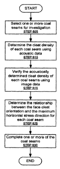
[0059] FIG. 6 depicts a flowchart in accordance with one or more embodiments
of the invention. The process set forth in FIG. 6 may be used to begin and/or
improve production of a CBM reservoir (e.g., CBM reservoir (500) discussed
above in reference to FIG. 5). Those skilled in the art, having the benefit of
this detailed description, will appreciate that some steps in FIG. 6 may be
omitted, repeated, and/or rearranged in a different order than that shown in
FIG. 6. Accordingly, the specific arrangement of steps shown in FIG. 6 should
not be construed as limiting the scope of the invention.
[0060] Initially, coal seams are selected for investigation (i.e., for
characterization) (STEP 605). The selected coal seams may be penetrated by a
single CBM reservoir, or said coal seams may be penetrated by multiple CBM
reservoirs in one or more oilfields. In STEP 610, the cleat density of each
coal
seam is determined by analyzing acoustic data (e.g., acoustic logs). In STEP
615, the acoustically determined cleat density of each coal seam is
verified/validated by analyzing image data (e.g., image logs). In STEP 625,
the
relationship between the face cleat orientation and the maximum horizontal
stress (HS) direction is determined for each coal seam. In STEP 630, one or
more of the coal seams are selected for completion based on the cleat density,
the face cleat orientation, and the maximum horizontal stress (HS) direction.
The steps of FIG. 6 are described in detail below.
17
CA 02694230 2010-01-20
WO 2009/038886 PCT/US2008/071965
[0061] Although the process depicted in FIG. 6 uses image data to verify
acoustically determined cleat densities, in one or more embodiments of the
invention, the acoustic data is used to verify cleat densities determined from
image data.
[0062] In STEP 610, the cleat density of each coal seam is determined using
acoustic data. FIG. 7 depicts a process for determining the cleat density of a
coal seam using acoustic data. Those skilled in the art, having the benefit of
this detailed description, will appreciate that some steps in FIG. 7 may be
omitted, repeated, and/or rearranged in a different order than that shown in
FIG. 7. Accordingly, the specific arrangement of steps shown in FIG. 7 should
not be construed as limiting the scope of the invention.
[0063] Initially, acoustic data is obtained for each selected coal seam (STEP
705). The acoustic data may be an acoustic log (i.e., a recording of acoustic
properties as functions of depth) for an entire CBM reservoir or for a
specific
coal seam within the CBM reservoir. In one or more embodiments of the
invention, obtaining acoustic data includes performing a full waveform sonic
acquisition to obtain a monopole waveform (e.g., Stoneley waveform,
compressional waveform) and a flexural waveform over a range of frequencies.
[0064] In STEP 710, a Stoneley slowness value is extracted from the acoustic
data at multiple depths within each coal seam. In one or more embodiments of
the invention, each of the Stoneley slowness values are extracted from the
obtained monopole waveform using a slowness time coherence (STC)
technique. Those skilled in the art, having the benefit of this detailed
description, will appreciate a Stoneley waveform is sensitive to the
formation/borehole interface. Accordingly, changes in permeability and the
presence of open fractures along said interface attenuate the Stoneley
waveform and affect the slowness of the measured Stoneley waveform.
[0065] In STEP 715, a Stoneley reflection coefficient (STRC) and a Stoneley
transmission coefficient (STTC) are calculated for each of the extracted
18
CA 02694230 2010-01-20
WO 2009/038886 PCT/US2008/071965
Stoneley slowness values (i.e., STEP 710). Those skilled in the art, having
the
benefit of this detailed description, will appreciate that in highly cleated
coal
seams (i.e., coal seams of high cleat density), transmitted Stoneley wave
energies are attenuated and reflected Stoneley wave energies are negligible.
As
a result, the calculated STTC and STRC values are small within coal seams of
high cleat density.
[0066] In STEP 720, a shear slowness (1/Vs) value and a compressional
slowness (1/Vp) value are extracted from the acoustic data at multiple depths
within each coal seam. In one or more embodiments of the invention, said
multiple depths correspond to the multiple depths discussed above in reference
to STEP 710. A Vs value is a measurement of shear modulus (i.e., a modulus
of rigidity). The presence of high fractures (i.e., cleats) in a soft rock
like coal
reduces the rigidity of formation, which in turn reduces Vs. A Vs value may be
extracted from the obtained flexural waveform using a dispersive STC
technique and bias correction. In contrast, a Vp value may be extracted from
the obtained monopole waveform.
[0067] In STEP 735, the cleat density of each coal seam is determined using
STRC, STTC, and/or Vp/Vs. In one or more embodiments of the invention,
determining the cleat density of each coal seam corresponds to determining the
cleat density of each coal seam relative to other coal seams (i.e., ranking
the
multiple coal seams according to increasing (or decreasing) cleat density).
[0068] As discussed above, a coal seam with low STRC and STTC values
indicates said coal seam has a high cleat density. As also discussed above, a
coal seam having low Vs values also indicates said coal seam has a high cleat
density. Accordingly, coal seams having low STRC and STTC values and/or
low Vs values may be deemed as having a high cleat density and thus having a
high potential for production (e.g., production of hydrocarbons).
[0069] In one or more embodiments of the invention, ranking multiple coal
seams according to cleat density includes generating a chart having the Vp/Vs
19
CA 02694230 2010-01-20
WO 2009/038886 PCT/US2008/071965
ratio as one axis, compressional slowness as a second axis, and depth as a
third
axis. The corresponding values for each coal seam may be plotted on said
chart. The cleat density of a coal seam may be ranked according to the average
or median of said coal seam's Vp/Vs ratios. Thus, a coal seam with a high
average or high median Vp/Vs ratio is deemed as having a higher cleat density
than a coal seam with a smaller average or a smaller median Vp/Vs ratio.
[0070] In one or more embodiments of the invention, ranking multiple coal
seams according to cleat density includes generating a chart having STRC or
STTC as one axis, and compressional slowness and a second axis. The
corresponding values for each coal seam may be plotted on said chart. The
cleat density of a coal seam may be ranked according to the average or median
of said coals seam's STRC and/or STTC values. Thus, a coal seam with a low
average or low median STRC or STTC value is deemed as having a higher
cleat density than a coal seam with a higher average or higher median STRC or
STTC value.
[0071] Referring back to FIG. 6, in STEP 615 the acoustically determined cleat
density of each coal seam is verified using image data. FIG. 8 shows a process
for verifying (e.g., validating) the acoustically determined cleat density of
a
coal seam. Those skilled in the art, having the benefit of this detailed
description, will appreciate that some steps in FIG. 8 may be omitted,
repeated,
and/or rearranged in a different order than that shown in FIG. 8. Accordingly,
the specific arrangement of steps shown in FIG. 8 should not be construed as
limiting the scope of the invention.
[0072] Initially, image data for the coal seam is obtained (STEP 805). The
image data may be a borehole electrical image log (i.e., a recording of
electrical
micro-resistivity properties as functions of depth) for an entire CBM
reservoir
or for a specific coal seam within the CBM reservoir. The borehole electrical
image log must be of sufficiently high resolution (e.g., fraction of an inch)
to
visualize both small-scale cleats concentrated within individual coal bands of
the coal seam and large-scale cleats cross-cutting multiple maceral bandings.
CA 02694230 2010-01-20
WO 2009/038886 PCT/US2008/071965
In one or more embodiments of the invention, the electrical image log is
calibrated with respect to a shallow resistivity log prior to use in analyzing
coal
seams. In one or more embodiments of the invention, the image data is a
Fullbore Formation Microlmager (FMI) log generated using a FMI.
[0073] Those of ordinary skill in the art, having the benefit of this detailed
description, will appreciate that natural fractures (e.g., cleats) appear more
continuous on image logs, that natural fractures generally occur in more than
one direction, and the nature fractures have varied morphology. Mechanically
induced fractures (e.g., borehole breakouts, drilling induced fractures) tend
to
occur in a preferred direction based on the present day local stresses and the
orientation of the borehole. Accordingly, natural fractures and mechanically
induced fractures may be easily distinguished using image logs.
[0074] Those skilled in the art, having the benefit of this detailed
description,
will also appreciate that cleats are fractures that commonly occur
perpendicular
or at very high angles to the coal bedding. Accordingly, in STEP 810, high
angle natural fractures in the coal seam are identified from the image data
and
designated as cleats. In one or more embodiments of the invention, dip
analysis of the image data is used to identify primary and secondary fracture
sets (i.e., face cleats, butt cleats) and the directions of said primary and
secondary fracture sets.
[0075] In one or more embodiments of the invention, identifying cleats
includes generating a histogram plotting the frequency of the identified
fractures against the angles of said identified fractures. A coal seam having
a
large number (i.e., high frequency) of high angled fractures may be deemed as
having a high cleat density.
[0076] In STEP 815, the fracture density and the fracture aperture for the
coal
seam is calculated. In one or more embodiments of the invention, the fracture
density is calculated as the number of fractures per unit depth of the coal
seam.
In one or more embodiments of the invention, the fracture aperture is
21
CA 02694230 2010-01-20
WO 2009/038886 PCT/US2008/071965
calculated based on a relationship between flushed zone resistivity, mud
resistivity, and the excess current flowing through the open fracture filled
with
conductive mud. In one or more embodiments of the invention, the fracture
aperture (W) is given by:
W = c=A=Rmb=Rxo(l-b)
where c is a constant, b is a constant from tool modeling; A is excess current
divided by voltage and integrated along a line perpendicular to the fracture
trace; Rm is mud resistivity; and Rxo is flushed zone resistivity. A high
fracture aperture (W) indicates the cleats are "more open" and well suited for
hydrocarbon production. A low fracture value (W) indicates the cleats are
"less open" and not as well suited for hydrocarbon production.
[0077] In STEP 820, the fraction density and/or the fraction aperture of the
coal
seam is used to verify/validate the acoustically determined cleat density of
the
coal seam. In one or more embodiments of the invention, verifying the
acoustically determined cleat density of a coal seam includes correlating the
multiple Vp/Vs ratios of the coal stream with the frequency of high angled
fractures. Specifically, a coal seam identified as having a high cleat density
based on large Vp/Vs ratios will also have a high frequency of high angled
fractures. Similarly, a coal seam identified as having a low cleat density
based
on low Vp/Vs ratios will also have a low frequency of high angled fractures.
Further, a coal seam identified as having the highest cleat density based
Vp/Vs
ratios may also have the highest frequency of high angled fractures.
[0078] In one or more embodiments of the invention, verifying the acoustically
determined cleat density of a coal seam includes correlating the multiple STTC
and STRC values of the coal seam with the frequency of high angled fractures.
Specifically, a coal seam identified as having a high cleat density based on
low
STTC and STRC values will also have a high frequency of high angled
fractures. Similarly, a coal seam identified as having a low cleat density
based
on high STTC and STRC values will have a low frequency of high angled
22
CA 02694230 2010-01-20
WO 2009/038886 PCT/US2008/071965
fractures. Further, a coal seam identified as having the highest cleat density
based on STTC and STRC value may also have the highest frequency of high
angled fractures.
[0079] In one or more embodiments of the invention, the fracture aperture
value
is used to check the suitability of a coal seam for hydrocarbon production. In
other words, even though two coal seems may be identified as having similar
cleat densities, the coal seam with the higher fracture aperture is more
suited
for hydrocarbon production. Accordingly, acoustically determined cleat
densities and/or cleat densities determined using image data may be cross-
checked with fracture aperture values.
[0080] In one or more embodiments of the invention, when a coal seam is
determined to have a high cleat density based on acoustic data (e.g., Vp/Vs
ratio, STRC, STCC, etc.), but the corresponding image data (e.g., frequency of
high angled fractures, fracture aperture) of said coal seam does not confirm
the
high cleat density (i.e., there is poor correlation between the acoustic data
and
image data with respect to cleat density), the acoustically determined cleat
density is not verified (i.e., validated) by the image data.
[0081] Returning to FIG. 6, in STEP 625, the relationship between the face
cleat orientation and the maximum HS direction is determined for each coal
seam. Those skilled in the art, having the benefit of this detailed
description,
will appreciate that the fast shear azimuth direction is an indication of
present
day maximum HS direction. Accordingly, in one or more embodiments of the
invention, an acoustic anisotropic analysis (e.g., Alfrod rotation) is
performed
on the obtained flexural waveform from a coal seam to determine the
maximum HS direction for said coal seam.
[0082] Further, those skilled in the art, having the benefit of this detailed
description, will also appreciate that the face cleat orientation may be
determined from an image log of the coal seam. For example, face cleat
orientation may be determined using dip analysis (discussed above in reference
23
CA 02694230 2010-01-20
WO 2009/038886 PCT/US2008/071965
to STEP 810 of FIG. 8). Both the face cleat direction and the direction of
maximum HS may be plotted on a stereo plot to determine the relationship
between face cleat direction and maximum HS direction. In one or more
embodiments of the invention, when the maximum HS direction is parallel to
the face cleats, coal permeability is increased and the HS helps keep the face
cleats open, effectively increasing primary flow during production.
[0083] In STEP 630, one or more of the coal seams are selected for completion
based on cleat density, face cleat orientation, and maximum HS direction. In
one or more embodiments of the invention, only coal seams having verified
cleat densities are selected for completion. In addition, only coal seams that
satisfy predetermined average Vp/Vs ratios and/or predetermined STRC/STTC
values are selected for completion. Further, in one or more embodiments of the
invention, only coal seams having a face cleat orientation parallel to the
maximum HS direction are selected for completion.
[0084] In one or more embodiments of the invention, the completion method
(e.g., horizontal well, hydraulic fracture, open hole or cavity, etc.) is
selected
based on the orientation of the face cleats relative to the maximum HS
direction. Specifically, the completion method is selected to maintain well
bore stability and increase production of hydrocarbons.
[0085] FIG. 9 depicts an example in accordance with one or more
embodiments of the invention. As shown in FIG. 9, the example includes a
Vp/Vs vs. compressional slowness (i.e., DTCO) plot (901) for three coal seams
(i.e., Coal Seam A (915), Coal Seam B (920), Coal Seam C (925)). As
discussed above, the multiple Vp/Vs (905) values for each coal seam (915, 920,
925) correspond to different depths within each coal seam. Furthermore, said
multiple Vp/Vs (905) values and their corresponding compressional slowness
(910) values are determined from acoustic data (e.g., acoustic logs).
[0086] Those skilled in the art, having the benefit of this detailed
description,
will appreciate that the average Vp/Vs value for coal seam C (925) exceeds the
24
CA 02694230 2010-01-20
WO 2009/038886 PCT/US2008/071965
average Vp/Vs value for coal seam B (920). In addition, the average Vp/Vs
value for coal seam B (920) exceeds the average Vp/Vs value for coal seam A
(915). As discussed above, a coal seam with a high average or high median
Vp/Vs ratio is deemed as having a higher cleat density than a coal seam with a
smaller average or a smaller median Vp/Vs ratio. Accordingly, the plot (901)
indicates that coal stream A (915) has the lowest cleat density and coal seam
C
(925) has the highest cleat density.
[0087] Still referring to FIG. 9, the example also includes three histograms
(i.e.,
Histogram for Coal Seam A (930), Histogram for Coal Seam B (935),
Histogram for Coal Seam C (940)). As shown in FIG. 9, the histogram for coal
seam A (930) plots the frequency of fractures in coal seam A (931) by fracture
angle (932). Similarly, the histogram for coal seam B (935) plots the
frequency
of fractures in coal seam B (936) by fracture angle (937). Similar still, the
histogram for coal seam C (940) plots the frequency of fractures in coal seam
C
(941) by fracture angle (942). As discussed above, the number of fractures and
the angle of said fractures may be determined from image data (i.e.,
electrical
resistivity image logs).
[0088] Those skilled in the art, having the benefit of this detailed
description,
will appreciate that based on the histogram for coal seam C (940) and the
histogram for coal seam B (935), coal seam C (925) has more factures
exceeding a fracture angle of 70 degrees than coal seam B (920). Similarly,
based on the histogram for coal seam B (935) and the histogram for coal seam
A (930), it is evident that coal seam B (920) has more fractures exceeding a
fracture angle of 70 degrees than coal seam A (930). As discussed above, a
high frequency of high angled fractures indicates a coal seam with a high
cleat
density. Accordingly, the histograms (930, 935, 940) indicate coal seam C
(925) has the highest cleat density and coal seam A (915) has the lowest cleat
density.
[0089] In one or more embodiments of the invention, the acoustically
determined cleat densities are verified using the image data. In other words,
an
CA 02694230 2010-01-20
WO 2009/038886 PCT/US2008/071965
attempt is made to correlate the acoustically determined densities with the
image data. For example, as discussed above, the plot (901) indicates that
coal
seam C (925) has a high cleat density. This is verified by the histogram for
coal seam C (940), which also indicates coal seam C (925) has a high cleat
density. Similarly, the plot (901) indicates that coal seam A (915) has the
relatively smallest cleat density. This is verified by the histogram of coal
seam
C (925), which verifies that coal seam A (915) has the smallest cleat density.
In one or more embodiments of the invention, as coal seam C (925) has the
highest acoustically determined cleat density, and as said acoustically
determined cleat density is verified by the image data, at least coal seam C
(925) is selected for completion.
[0090] Although the example in FIG. 9 makes use of Vp/Vs ratios to
acoustically determine cleat densities, Vp/Vs ratios and/or STTC/STRC values
may be used to acoustically determine cleat densities.
[0091] The invention may be implemented on virtually any type of computer
regardless of the platform being used. For example, as shown in Figure 10, a
networked computer system (1000) includes a processor (1002), associated
memory (1004), a storage device (1006), and numerous other elements and
functionalities typical of today's computers (not shown). The networked
computer (1000) may also include input means, such as a keyboard (1008) and
a mouse (1010), and output means, such as a monitor (1012). The networked
computer system (1000) is connected to a local area network (LAN) or a wide
area network (e.g., the Internet) (not shown) via a network interface
connection
(not shown). Those skilled in the art will appreciate that these input and
output
means may take other forms, now known or later developed. Further, those
skilled in the art will appreciate that one or more elements of the
aforementioned computer (1000) may be located at a remote location and
connected to the other elements over a network.
[0092] Further, the invention may be implemented on a distributed system
having a plurality of nodes, where each portion of the invention may be
located
26
CA 02694230 2010-01-20
WO 2009/038886 PCT/US2008/071965
on a different node within the distributed system. In one embodiment of the
invention, the node corresponds to a computer system. Alternatively, the node
may correspond to a processor with associated physical memory. Further,
software instructions to perform embodiments of the invention may be stored
on a computer readable medium such as a compact disc (CD), a diskette, a
tape, a file, or any other computer readable storage device.
[0093] While the invention has been described with respect to a limited number
of embodiments, those skilled in the art, having benefit of this disclosure,
will
appreciate that other embodiments can be devised which do not depart from the
scope of the invention as disclosed herein. Accordingly, the scope of the
invention should be limited only by the attached claims.
27