Note: Descriptions are shown in the official language in which they were submitted.
CA 02695427 2010-02-02
WO 2009/020777 PCT/US2008/071125
TITLE
METHODS AND SYSTEMS FOR MAKING A GPS SIGNAL VITAL
BACKGROUND
[001] The use of global positioning system (GPS) receivers on trains has been
proposed for a variety of train control and safety systems. For example, U.S.
Patent No.
6,081,769 to Curtis discloses using GPS receivers mounted at the front and
rear of a train to
determine a length of a train. U.S. Patent No. 6,459,965 to Polivka discloses
a system in
which GPS receivers are included on each train and position reports are sent
from the train to
wayside devices so that appropriate wayside signals can be generated in order
to avoid
collisions between trains. The assignee of the present application is the
owner of several co-
pending U.S. patent applications and issued U.S. patents involving the use of
GPS receivers
on trains, including U.S. Patent No. 7,024,289 (directed toward using GPS
receivers mounted
on the front and rear of trains to detect train separation) and U.S. Patent
Application Serial
No. 10/938,820 (directed toward a method for determining a train's position on
a train track
with a GPS receiver to a greater accuracy than the accuracy of the GPS
receiver). The
contents of all of the foregoing are hereby incorporated herein by reference.
[002] For train control systems that rely on GPS as the primary means of
position
determination, characterization of the magnitude of the GPS position error is
critical. If the
position of a train is not reliably known, then any attempted control of the
train with respect
to speed or limits of authority is equally unreliable. The magnitude of the
error must be
known and accounted for in all positional operations. This characterization of
the error
becomes the basis of a first-order safety factor or safety distance.
[003] New regulations for train control systems now mandate that new systems
shall
meet or exceed the IEEE 1483 standard for fail-safe or vital operation. While
the 1483
-1-
CA 02695427 2010-02-02
WO 2009/020777 PCT/US2008/071125
standard specifies documentation and verification methods, other published
standards specify
acceptable probabilities of error (or hazard occurrences) given the frequency
or probability of
said occurrence. With respect to hazard determination, it can be said that a
system is "vital"
if the probability of a hazard is greater than six sigma. The probability of a
single occurrence
existing outside the range of -6 to +6 sigma is: 6.076 E-9. Said another way,
the odds are 1 in
164,600,000 that the occurrence exists. This probability is sufficiently low
to meet the
definition of "vital." It should be noted that for any system which is deemed
fail-safe, all
unique inputs into the system (that are not diversely checked) must also meet
the same
statistical confidence as the overall system.
[004] Other systems may use differential GPS and GPS position over-sampling
and
data averaging in an effort to determine the true mean value of the position
of the receiver.
This may also be an effort to obtain vitality statistically from a GPS
receiver that is not vital
with respect to hardware, software, or communication protocols.
[005] One problem with trying to determine the statistical confidence of GPS
systems and the reported GPS positions is the fact that successive position
messages are not
statistically independent and therefore cannot be used as fully independent
samples in any
statistical analysis. This is due to the fact that the algorithms employed
within the GPS
receivers typically use Kalman filters and other analog and digital signal
processing
techniques which have an internal signal history or `wind-up' as the basis for
the
mathematics. This means that the mathematics within GPS systems contain a
history or
phase lag which uses trends and historic data in the generation of the present
solution.
Therefore, the individual solutions are interrelated and are not statistically
independent and
may not be treated as such with respect to error or confidence analysis.
[006] The exact time delay or phase lag inherent in the system, and the
magnitudes
thereof, are difficult to assess, but exist nevertheless. Rigorous
quantification of the time
-2-
CA 02695427 2010-02-02
WO 2009/020777 PCT/US2008/071125
delay or phase lag is possible, but requires analysis of the computational
techniques within
the receiver and analysis of the circuitry as applicable.
SUMMARY
[007] The aforementioned vulnerabilities inherent in a typical GPS system are
removed by providing a means of validating the GPS performance and
differential
corrections by direct measurement. Using this technique, the apparent error
can then be
transmitted to client systems along with the applicable corrections in some
embodiments. In
one embodiment, a GPS receiver at a fixed location is used as a differential
GPS base station.
The differential GPS base station receives data from all available satellites,
checks the health
of individual satellites, and determines individual corrections by comparing
the position data
derived from the satellites to the known fixed location. The differential GPS
base station
then generates correction messages that inform other GPS receivers as to the
corrections
needed for specific satellites. In some embodiments, a second fixed GPS
receiver (preferably
a different make and model), which is referred to herein as a "validating
receiver", validates
the corrections generated by the first receiver before said corrections are
transmitted to
mobile GPS systems. The corrections are validated by applying said corrections
to the
position generated by the fixed second receiver and then comparing the
reported position of
the second receiver to the known position of the fixed second receiver.
[008] Preferably, data communications between the GPS receivers at the fixed
locations, as well as communications of the correction data to the GPS
receivers onboard the
trains, should employ a CRC-32 or equivalent method to protect against data
being corrupted
during transmission. Such methods can, when used appropriately, provide a six
sigma
confidence that any corruption of the data will be detected. All
communications involving
-3-
CA 02695427 2010-02-02
WO 2009/020777 PCT/US2008/071125
data of a vital nature are preferably performed using CRC-32 or equivalent
methods to
maintain the desired statistical confidence in data and guard against
corruption.
[009] In another embodiment, a train or other vehicle traveling on a fixed
path is
provided with a database that includes fixed paths or data from which fixed
paths can be
determined. Position reports from GPS receivers located on the vehicle are
compared to the
vectors of the fixed paths in the database. If the distance from the position
reported by the
GPS receiver orthogonal to the nearest point on the fixed path vector is
greater than the stated
accuracy of the GPS receiver, the position report is discarded or other
corrective action is
taken.
[010] In still another embodiment, two GPS receivers are mounted on a moving
vehicle at a known distance apart from each other. When the vehicle is a
train, the receiver
may be mounted on different vehicles or on the same vehicle. Preferably, the
GPS receivers
and their chipsets are manufactured by two different manufacturers in order to
provide
diversity. In embodiments employing differential base stations, one of the GPS
receivers
onboard the train is preferably the same make and model as one of the GPS
receivers
(preferably the Validating GPS receiver) used in the differential base
station. The distance
between position reports from the two mobile receivers can be determined and
compared to
the known distance between the two mobile receivers. The difference is then
compared to an
allowable uncertainty. In some embodiments an additional check may be
performed which
requires the vehicle to be located on a fixed path, which then allows the
direction of travel
indicated by fixed path vector to be cross checked with the direction of
travel indicated by the
vehicle orientation. The vehicle orientation is determined by the reported
positions of the dual
mobile GPS receivers. In other embodiments in which the GPS receivers provide
a direction
of travel while moving, the direction of travel indicated by each of the
receivers can be
compared and cross-checked. If the vehicle is traveling on a fixed path, then
the direction of
-4-
CA 02695427 2010-02-02
WO 2009/020777 PCT/US2008/071125
travel indicated by mobile receivers may be cross-checked with the fixed path.
In such
embodiments, the GPS receivers are preferably mounted as far apart as possible
(e.g., on
opposite ends of a car when both receivers are installed on a single
locomotive or other car).
In yet another check, the speed indicated by the GPS receivers can be compared
and cross-
checked with the speed indicated by a separate speed measuring device, such as
an axle drive
speedometer on a train or the voltage across a DC traction motor or the
frequency driving an
AC traction motor in a locomotive.
[011] In still other embodiments, particularly applicable to embodiments in
which a
vehicle travels on a fixed path, a device at a known location alongside the
fixed path is used
to correlate a position reported by a GPS receiver. The device has a sensor
that will detect
the time at which the vehicle passes the device and transmit that information
back to the
vehicle. In some embodiments, especially those in which the devices are not
permanently
located at a particular position, the device also transmits its position. In
other embodiments,
the vehicle has a database that includes the locations of the devices so that
it is not necessary
for the device to transmit its location. In such embodiments, the device may
transmit an
identification code so that the device is unambiguously identifiable and the
corresponding
device location can be retrieved from the database. Alternatively, each device
may be
assigned its own frequency, or the devices may be separated by sufficient
distances such that
only one device can be within communication range of the vehicle at any one
time.
[012] The time at which the vehicle passes the device can be used to determine
the
position reported by the GPS receiver at the same time. If there is no
position report that
corresponds to the exact time at which the vehicle passes the device, the
difference in time
between a contemporaneous position report from the GPS receiver and the time
reported by
the device along with the velocity (and, in some embodiments, acceleration) of
the vehicle
are used to synchronize the GPS position report to the message from the device
so that the
-5-
CA 02695427 2010-02-02
WO 2009/020777 PCT/US2008/071125
distance between the synchronized GPS position report is compared to the known
position of
the device. The difference between these two positions is then compared to the
stated
accuracy of the GPS receiver. Preferably, the device in such embodiments is a
transponder.
In other embodiments, the device is a wheel detector such as a hot bearing
detector used in
connection with railroads. In such embodiments, the device transmits the times
at which the
first and last wheels were detected along with the total number of wheels that
were detected.
This data can be used to verify that no cars on the train have become
detached.
[013] In yet another embodiment, a receiver or transceiver for digital
communications, such as a receiver configured to conduct communications
pursuant to the
802.11 standard, is configured to measure the change in carrier phase or the
subcarrier bit
timing caused by relative movement between the receiver and a point such as a
transmitter or
transceiver located at a train station. By measuring the direction of the
shifts, the receiver can
determine when direction changes, signifying the passing of the point. By
measuring the
magnitude of the shifts, the relative velocity can be determined. The passing
of the point
and/or the relative velocity can then be compared to position and/or speed
infonnation from
the GPS receiver to verify that the latter is correct (i.e., operating within
its specified
accuracy).
BRIEF DESCRIPTION OF THE DRAWINGS
[014] The aforementioned advantages and features of the present invention will
be
more readily understood with reference to the following detailed description
and the
accompanying drawings in which:
[015] Figure 1 is a block diagram of a train control system according to one
embodiment of the invention.
[016] Figure 2 is a flowchart of a technique for detecting an error in a
position
reported by a GPS receiver according to one embodiment.
-6-
CA 02695427 2010-02-02
WO 2009/020777 PCT/US2008/071125
[017] Figure 3 is a flowchart of a technique for detecting an error in a
position
reported by a GPS receiver according to a second embodiment.
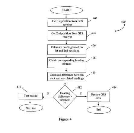
[018] Figure 4 is a flowchart of a technique for detecting an error in a
position
reported by a GPS receiver according to a third embodiment.
[019] Figure 5 is a flowchart of a technique for detecting an error in a
position
reported by a GPS receiver according to a fourth embodiment.
[020] Figure 6 is a flowchart of a technique for detecting an error in a
position
reported by a GPS receiver according to a fifth embodiment.
[021] Figure 7 is a flowchart of a technique for detecting an error in a
position
reported by a GPS receiver according to a sixth embodiment.
[022] Figure 8 is a flowchart of a technique for detecting an error in a
position
reported by a GPS receiver according to a seventh embodiment.
[023] Figure 9 is a plot of a normalized Gaussian error distribution.
[024] Figure 10 is a logarithmic plot of the Gaussian error distribution of
Figure 9.
DETAILED DESCRIPTION
[025] In the following detailed description, a plurality of specific details,
such as
accuracies of GPS receivers, are set forth in order to provide a thorough
understanding of the
embodiments discussed below. The details discussed in connection with these
embodiments
should not be understood to limit the present invention. Furthermore, for ease
of
understanding, certain method steps are delineated as separate steps; however,
these steps
should not be construed as necessarily distinct nor order dependent in their
performance.
[026] The present invention is believed to be particularly well suited for use
in the
railroad industry and hence will be discussed primarily in that context
herein. The present
invention should not be understood to be so limited.
-7-
CA 02695427 2010-02-02
WO 2009/020777 PCT/US2008/071125
[027] In the GPS system, there are three basic terms which describe the
behavior and
data within the system. They are generally described as accuracy /
repeatability / availability.
Accuracy and repeatability are typically expressed as a distance while
availability is typically
expressed as probability or as a percentage with respect to time. The term
availability is
related to the number of satellite vehicles in service, the mask angle, and
the changing nature
of the geometry of the GPS satellite constellation. This is expressed in the
HDOP or PDOP
variability. As an example, standard GPS accuracy / availability is typically
specified as a
one sigma error of 8 meters (95% of the time). This means that the position
information from
standard GPS will be within 8 meters of the true position at least 95% of the
time.
[028] For a system which exhibits a normal distribution of errors the term
accuracy
refers to the absolute error that the reported value exhibits from the true
value. The errors
follow the distribution.
[029] Repeatability or precision refers to the behavior where a system will
reliably
repeat the same data even though the data has an existing error. The error is
typically
repeated. Such a system could be termed `repeatable' by not necessarily
accurate.
[030] For GPS, the errors in the position fixes follow a normal distribution.
Under
such a distribution, for any given data point, the probability of the
occurrence of an error can
be calculated given the magnitude of the error (`r').
[031] The formula is:
[CY]
2
Err(r) e
[032] GPS has further accuracy degradations due to the geometry of the
satellite
constellation and the geometry (locations) of the satellites it is able to
track. If a train wishes
to know its location on a track, then a satellite perpendicular to the track
is of little or no use.
This is because the mobile GPS device can only measure the receiver's distance
from the
-8-
CA 02695427 2010-02-02
WO 2009/020777 PCT/US2008/071125
satellite. On the other hand, if a satellite is collinear with the track, then
the distance from
that satellite provides the best possible data with respect to the `milepost.'
[033] Trains are normally shielded (satellites are hidden from view) by bluffs
or the
sides of hills. This is a natural consequence of the track being built on a
semi-level path.
Fortunately the paths tend to have few sharp bends. This generally provides a
good "view,"
or unobstructed line-of-sight path, along the principal axis of interest (the
axis that is
collinear with the track).
[034] The term for the constellation geometric uncertainty is "dilution of
precision"
or DOP. The DOP can be reported in a number of ways. HDOP is the horizontal
only (2-D),
and PDOP is the position dilution of precision (3-D). The GPS satellite
constellation almost
always has much greater uncertainty in the vertical direction for the same
reasons noted
earlier about milepost uncertainty. At any given time there are usually very
few satellites at a
high angular altitude (far above the horizon), relative to a GPS receiver.
[035] Using the HDOP provides the data of the greatest interest for railroad
navigation, the apparent errors in the latitude and longitude. From the error
equation (1)
above, HDOP can be accounted for by a simple modification:
r
h(y )2
2
Err(r, h) ~ e
~
Where the term `h' is the HDOP value, which is calculated using the geometric
positions of
the satellites used in the solution.
[036] A normalized error distribution takes the form of the plot illustrated
in Fig. 9,
-9-
CA 02695427 2010-02-02
WO 2009/020777 PCT/US2008/071125
where `x' is the standard deviation. The error distribution is plotted in a
logarithmic fashion
in Fig. 10. From Fig. 10 it can be seen that at six sigma (x is equal to 6),
the probability of an
occurrence happening outside of the confines of the curve is quite low.
[037] To increase the statistical confidence in the positions generated by a
GPS
system, one technique is to expand the error range to an extent that the
probability of a data
point outside the error "window" is six sigma or higher. Since GPS is defining
a point, the
error "window" can best be described as an error "radius" since the error is
normally reported
as circular. This can be calculated using a standard, non-differential, single-
receiver GPS
system. Whereas the one sigma error in standard GPS is in the range of 8
meters, a six sigma
error is on the order of 48 meters. This is with an HDOP of 1.0 which is an
optimum, and
seldom seen, condition.
[038] In addition to the position fix errors discussed above, there are other
sources of
errors in GPS receivers. These include foliage, moisture (typically on
foliage), weather,
multi-path, and others.
[039] Whereas in simple computer systems it may be trivial to build a
dedicated
single function that is deemed vital, it is quite different for most
mechanical systems such as
the braking system in a train. The more complex the system, the more difficult
it is to obtain
or prove vital operation. Because of the complexity and time involved, the
design of a vital
system is typically a dedicated task reserved for specific applications or
processes.
[040] The same is true of the majority of GPS receivers. Most commercial GPS
systems are not designed to be vital. To begin with, the communication
protocols employed
by commercial GPS receivers are not vital with respect to the statistical
confidence of a
single message. This includes the NEMA protocol.
[041] Different GPS manufacturers typically use the NEMA protocol as well as
different proprietary serial communication protocols. These serial
communication protocols
-10-
CA 02695427 2010-02-02
WO 2009/020777 PCT/US2008/071125
use different methods to verify the integrity of the communicated data.
Methods can range
from 8 bit checksums to 16 bit CRCs (cyclical redundancy codes).
Statistically, the
checksum is a very poor method of detecting a data error, and neither the
checksum, nor
CRC 16, approaches the six sigma statistical level of certainty that is
required to be vital.
Thus, GPS receivers cannot be made failsafe or vital by only assigning a large
error radius to
a single data communication. Therefore at a minimum, a multiplicity of
communications is
required.
[042] Also, the internal calculations and processes within the GPS receivers
generally do not meet the aforementioned vitality standards. Internal data may
not be
protected from corruption, and the processors and processes may not be vital.
This is due to
the fact that a typical commercial GPS receiver was never designed and
manufactured with
fail-safe or vital navigation in mind. If it was, then the manufacturer would
generally select a
far more robust communications protocol than what is commonly found within the
industry.
[043] Also, as mentioned previously, multiple position fixes from one receiver
cannot be treated as wholly separate, statistically unique, position fixes or
samples due to
pipelining effects in the internal mathematics. This means that the GPS
receivers tend to be
repeatable, even with an existing error.
[044] Another noteworthy issue is that the statistical confidence in checksums
and
CRCs depends upon the size of the data that the checksum or CRC is supposed to
protect.
The greater the data size within the encapsulation, the lower the confidence
that a single or
multiple bit error can be reliably detected.
[045] The embodiments discussed below address the issues discussed above. The
motivation behind these embodiments is to increase the confidence of the
position solutions,
or at a minimum, characterize the errors generated by GPS receivers.
-11-
CA 02695427 2010-02-02
WO 2009/020777 PCT/US2008/071125
[046] Referring now to Figure 1, a system 100 according to one embodiment
includes a processor 110 connected to a first GPS receiver 120 and a second
GPS receiver
130. In some embodiments, the processor 110 is a part of a train control
system (or is in
communication with a train control system) and a result of the techniques
discussed below is
used by the train control system for the purpose of controlling movement of
the train. (As
used herein, a train control system is a system that controls movement of the
train, such as by
activating or deactivating propulsion and braking systems. The train control
system can be of
both the active type, in which the train control system is primarily
responsible for controlling
the train's propulsion and/or braking systems for movement of the train, and
the passive type,
in which a human being is primarily responsible for controlling the train's
propulsion and
braking systems and the train control system acts only when the train is or is
about to be
moved in an unsafe manner due to the commands being sent to the propulsion
and/or braking
system by the human being.) In some embodiments of the invention, the first
and second
GPS receivers 120, 130 are made by the same manufacturer and include the same
GPS
chipsets. In other embodiments, the GPS receivers 120, 130 are manufactured by
different
manufacturers and include different GPS chipsets.
[047] Preferably, the first GPS receiver 120 is mounted at or near the front
of a lead
locomotive on the train and the second GPS receiver 130 is mounted at or near
the rear of the
lead locomotive or at the front of the second locomotive. Mounting the first
and second GPS
receivers 120, 130 at opposite ends of a single locomotive is advantageous
because the
distance between them will remain fixed. If the two GPS receivers 120, 130 are
mounted on
different train vehicles (train vehicles is used herein to refer to both
locomotives and non-
powered wheeled vehicles forming part of a train) on a train, the distance
between them will
change somewhat due to "slack" between the cars. "Slack" refers to relative
movement
between two cars provided by the couplings that connect the two train
vehicles. A typical
-12-
CA 02695427 2010-02-02
WO 2009/020777 PCT/US2008/071125
coupling allows approximately one foot of relative movement between two train
vehicles that
are coupled to each other. It is therefore preferable to minimize the number
of train vehicles
that separate the two GPS receives 120, 130 if they are not mounted on
opposite ends of the
same train vehicle to ensure that the relative movement between the two train
vehicles due to
slack does not exceed the accuracy of the GPS receivers. For example, if each
GPS receiver
is accurate to within 10 meters, the difference between the positions reported
by the two
receivers at any one time may vary by as much as 20 meters. If two such
receivers were
separated by 100 vehicles on a train, the relative separation between the two
receivers may
vary by as much as 100 feet due to slack. This relative movement is much
larger than the
expected error of the two receivers and is undesirable because it makes it
difficult, if not
impossible, to determine whether a change in the relative difference in the
positions reported
by the receivers is due to a GPS error or slack.
[048] Although two GPS receivers 120, 130 are illustrated in Figure 1, it
should be
understood that some of the techniques discussed in further detail below
require only a single
GPS receiver and that some embodiments of the invention that practice such
techniques only
include a single GPS receiver.
[049] The processor 110 is also connected to a track database 140 (in other
embodiments of the invention, the track database 140 will be replaced by a
database of other
information, such as database that includes information about roads or
waterways as
appropriate). The track database 140 preferably includes a non-volatile memory
such as a
hard disk, flash memory, CD-ROM or other storage device, on which track data
is stored.
Other types of memory, including volatile memory, may also be used. In
preferred
embodiments, the track data comprises coordinates for a plurality of points
corresponding to
different locations on the track in a manner well known in the art. The points
are not
necessarily uniformly spaced. In some embodiments, the points are more closely
spaced
-13-
CA 02695427 2010-02-02
WO 2009/020777 PCT/US2008/071125
where the track is curved and less closely spaced where the track is straight.
The route or
fixed path between points can be described as a vector. In some embodiments,
the track data
also includes positions of wayside devices such as switches and other points
of interest such
as grade crossings, stations, etc. The track database 140 also includes
information concerning
the direction and grade of the track in some embodiments. The track database
140 further
includes information as to the route that the train is supposed to follow in
some embodiments
(in other embodiments, the route information is stored in a separate memory
associated with
the processor 110, not shown in Figure 1).
[050] Also connected to the processor I 10 is an output device 150. The output
device 150 may take various forms. In some embodiments, the output device 150
is a display
on which GPS information and/or an indication as to its correctness is
displayed. In other
embodiments, the output device 150 may be a communication link (such as an RS-
232C
interface) through which the processor reports GPS position and/or an
indication of its
correctness to some other system such as a train control system. Those of
skill in the art will
recognize that, in embodiments in which the processor I 10 also functions as a
train control
computer, the indication may be used internally by the processor 110 to
control movement of
the train and no output of the GPS information or its correctness is necessary
(although such
information may be displayed on a monitor or other device in such
embodiments).
[051] Various techniques for detecting errors in the GPS positions reported by
the
GPS receivers 120, 130 will now be discussed in further detail. One, several
or all of the
various techniques described below are performed in various embodiments. In
embodiments
that utilize multiple techniques, the multiple techniques may be performed in
different orders.
[052] In one embodiment requiring only a single GPS receiver, the processor
110
determines the minimum straight-line distance between the position reported by
the GPS
receiver and the closest point orthogonal to the track as reflected in the
track database. A
-14-
CA 02695427 2010-02-02
WO 2009/020777 PCT/US2008/071125
flowchart 200 illustrating this technique is shown in Figure 2. A position
report is obtained
from a GPS receiver at step 202. Next, the straight-line distance between the
position
reported by the GPS receiver and the nearest orthogonal point on the track is
calculated at
step 204. The nearest point may be a physical point within the track database
or a point
residing on a vector between two nearby points. If the distance is less than
or equal to the
threshold at step 208, the test is declared passed at step 212 and one or more
additional
checks may then be performed. If the distance is greater than the threshold at
step 208, a
GPS error is declared at step 210 and the process ends.
[053] For vehicle navigation, the action taken when a GPS error is declared
varies.
In some embodiments, GPS position report is simply discarded. In other
embodiments, other
information from an alternate source (such as an axle drive) is used. In yet
other
embodiments, a penalty brake application may be instituted to stop the train.
Those of skill in
the art will recognize that other actions are also possible.
[054] In a second embodiment utilizing two GPS receivers, the processor 110
calculates the difference in the positions reported by the two GPS receivers
120, 130 and
compares this difference to the known distance to detect errors in the
positions reported by
the GPS receivers. (Those of skill in the art will understand that there is
some uncertainty in
the `known' distance in embodiments in which the two GPS receivers 120, 130
are mounted
in different vehicles of the train due to slack as discussed above. In such
embodiments, the
total slack may be added to the threshold discussed below.) A flowchart 300 of
this
technique is illustrated in Figure 3. The processor 110 obtains a position
report from the first
GPS receiver 120 at step 302 and obtains a position report from the second GPS
receiver 130
at step 304. As discussed above, the GPS receivers 120, 130 may be mounted at
opposite
ends of a single locomotive or other train car, or may be mounted on separate
train cars.
These difference between the positions reported by the first and second
receivers is calculated
-15-
CA 02695427 2010-02-02
WO 2009/020777 PCT/US2008/071125
at step 306. Those of skill in the art will recognize that it will be
necessary to compensate the
difference in the positions reported by the GPS receivers if the times
associated with the
position reports are not equal and the train is moving. One way in which to
compensate for
differences in time between the position reports is to use a speed reported by
an axle drive
tachometer and the track database to "move" one of the position reports along
a heading
corresponding to the nearest section of the track by a distance equal to the
difference in time
between the reports multiplied by the speed reported by the axle drive
tachometer. Many
other compensation schemes are similarly available.
[055] The difference in the calculated distance between the positions reported
by the
GPS receivers 120, 130 and the known distance between the GPS receivers is
calculated at
step 308. This difference is compared to a threshold at step 310. The
threshold is based on
the stated accuracies of the two receivers. In some embodiments, the threshold
is simply the
sum of the stated accuracies for the two receivers. In other embodiments, the
threshold
includes an additional amount related to the accuracy to which the known
distance can be
determined (e.g., on a train, the difference in distance between adjacent cars
can change due
to slack as the train accelerates and decelerates). If the difference between
the known and
calculated distances is greater than the threshold at step 310, a GPS error is
declared at step
320. If the difference is less than or equal to the threshold at step 310,
this test is declared
passed at step 314. One or more additional techniques described below may be
performed
next.
[056] A third technique for detecting errors in GPS position reports is
illustrated in
the flowchart 400 of Figure 4. In this technique, a heading based on the
position reports from
two GPS receivers, or from a single GPS receiver at different points in time,
is calculated and
compared to the heading of the track as reflected by the track database. A
first GPS position
is obtained at step 402 and a second GPS position is obtained at step 404. In
some
-16-
CA 02695427 2010-02-02
WO 2009/020777 PCT/US2008/071125
embodiments, the first and second positions are taken simultaneously from the
first and
second GPS receivers 120, 130. In other embodiments, especially those that
employ only a
single GPS receiver, the first and second positions may be obtained from the
same GPS
receiver at different times when the train is moving. In the latter case, the
times may be
chosen such that distance between the first and second GPS positions is
approximately equal
to the length of the train. However, those of ordinary skill in the art will
recognize that
shorter or longer distances between the first and second GPS positions are
also possible.
[057] Next, the heading is calculated using the first and second GPS positions
at step
406. The heading of a corresponding section of track is then obtained at step
408. In some
embodiments, the track database 140 stores the track heading for each point in
the track
database. In other embodiments, the heading is not stored in the track
database but rather is
calculated using two points from the track database. These two points may be
the closest
point that has been passed by the train on its current trip and the closest
point that has not yet
been passed by the train, or may be the two closest points in the track
database to the most
recent position obtained from a GPS receiver.
[058] The difference between the track heading and the heading calculated
using the
positions from the GPS receiver(s) is then calculated at step 410. This
difference is compared
to a threshold at step 412. The threshold takes into account the stated
accuracies of the GPS
receivers and, preferably, the distance between the two points used to
calculate the GPS
receiver heading. If the difference between the GPS receiver heading and the
track heading is
greater than the threshold at step 412, a GPS error is declared at step 414
and the process
ends. If the difference between the headings does not exceed the threshold at
step 412, then
the test is declared passed at step 416.
[059] A fourth technique for detecting GPS receiver errors in those
embodiments
utilizing GPS receivers that provide speed is illustrated in the flowchart of
Figure 5. The
-17-
CA 02695427 2010-02-02
WO 2009/020777 PCT/US2008/071125
speed from the GPS receiver is obtained at step 502. A speed from an alternate
source is
obtained at step 504. The alternate source is preferably a wheel tachometer,
but may be any
suitable source as discussed above. The speed reported by the tachometer is
preferably
compensated for wear of the wheel using one or more of the techniques
disclosed in U.S.
Patent Nos. 6,721,228 or 6,970,774, or co-pending U.S. Patent App. Ser. No.
10/609,377.
The contents of each of the foregoing patents and patent applications are
hereby incorporated
by reference herein. In some embodiments for use with locomotives having
traction motors,
a speed may be approximated using the voltage across the traction motor. The
difference in
the speeds indicated by the GPS receiver and the alternate source is
calculated at step 506.
This difference is compared to a threshold at step 510. The threshold is based
on the stated
accuracies of the GPS receiver and the alternate source. If the difference in
speeds does not
exceed the threshold at step 510, then the test is declared passed at step 514
and the next test
(if any) is performed. If the difference in speeds exceeds the threshold, a
GPS error is
declared at step 512 in embodiments wherein the alternate speed source is
deemed more
reliable than the GPS receiver. Those of skill will also recognize that other
actions are also
possible. For example, in embodiments in which the alternate source is not
reliable, and
where one or more other techniques discussed above have indicated that there
is no GPS
receiver error, an error in the alternate source rather than the GPS receiver
may be declared.
[060] A fifth technique for detecting locomotive position errors that may be
caused
by GPS involves the use of a radio mounted onboard the train to measure bit
timing or carrier
phase. The onboard radio (not shown in Fig. 1) may be a transmitter, a
receiver, or a
transceiver (the term "radio" shall be used generically herein to refer to all
three). The
onboard radio is configured to communicate with another radio which is
preferably stationary
and preferably located along the wayside. In some preferred embodiments, the
onboard radio
is configured for 802.11 standard communications.
-18-
CA 02695427 2010-02-02
WO 2009/020777 PCT/US2008/071125
[061] A flowchart 600 illustrating one technique for using radios configured
to
detect errors in GPS position reports is illustrated in Fig. 6. Communications
are established
between the onboard radio and a stationary wayside radio at a known location
at step 602.
The onboard radio monitors the direction of a bit timing error at step 604.
The onboard radio
detects a change in the direction of the bit timing error at step 606. The
direction of bit
timing error will change as the train passes the stationary wayside radio. As
soon as the
direction changes at step 606, the processor 110 obtains a position report
from the GPS
receiver 120 at step 608 (alternatively, those of skill in the art will
recognize that periodic
GPS position reports may be obtained and the GPS position corresponding to the
moment in
time when the direction of the bit error changed may be interpolated using
these periodic
reports). The difference between the known position of the wayside radio and
the GPS
position corresponding to the change in the direction of the bit error is
calculated at step 610.
This distance is then compared to a threshold at step 612. The threshold is
based at least in
part on the stated accuracy of the GPS receiver. If the distance exceeds the
threshold at step
612, a GPS error is declared at step 614. If the distance does not exceed the
threshold at step
612, the test is passed at step 616 and the next test is performed.
[062] In some embodiments, the detection of the change in direction of the bit
error
is used to trigger a reset of the internal odometers (integrators) associated
with an axle drive
system to a position of the stationary wayside radio. This improves the
accuracy of the axle
drive system, which may be used in the event that GPS position reports are not
available or
are erroneous.
[063] The aforementioned technique requires the onboard radio to calculate a
direction of bit timing errors. Those of skill in the art will also recognize
that the detection of
a change in direction of carrier phase shift (i.e., a Doppler shift) may be
detected in
alternative embodiments. Moreover, the detection in change of bit error
direction or carrier
-19-
CA 02695427 2010-02-02
WO 2009/020777 PCT/US2008/071125
phase shift may be detected by the wayside radio rather than the onboard
radio. In such
embodiments, the wayside radio (which must be a transceiver or a transmitter)
signals the
onboard radio to alert it of the change, preferably along with a time at which
the change was
detected so that the processor 110 may determine a corresponding GPS position.
[064] Another technique for using radios to detect errors in GPS positions is
illustrated in the flowchart 700 of Figure 7. In this embodiment, the onboard
radio is
configured to measure a magnitude as well as a direction of the bit error (or,
alternatively, the
carrier phase shift). The magnitude of the bit error is indicative of the
relative velocity
between the onboard radio and the stationary radio. The magnitude of the bit
error is
calculated at step 702. The velocity is calculated using the magnitude of the
bit error at step
704. The velocity is obtained from the GPS receiver 120 at step 706. In some
embodiments,
the velocity will be provided directly by the GPS receiver 120. In other
embodiments, the
velocity must be calculated by the processor 110 based on a plurality of
position reports from
the GPS receiver 120. The processor 110 then determines the difference between
the GPS
velocity and the velocity calculated using the magnitude of the bit error at
step 708. If the
difference is greater than a threshold (again based on the stated accuracy of
the GPS receiver)
at step 710, a GPS error is declared at step 712 and the test ends. If the
difference is less than
the threshold at step 710, the test is passed at step 714 and the next test is
performed.
[065] Yet another technique for detecting errors in GPS receivers involves
correlating the vehicle's position with a known location. For example, in the
context of a
train control system, some embodiments include one or more wayside devices
equipped with
a device that detects the presence of a train for correlation purposes. In
preferred
embodiments of train control systems in which the wayside devices include
transceivers for
transmitting train control signals (such as track warrants, authorizations, or
signal aspects),
the wayside devices may include a detection device such as a hot bearing
detector, magnetic
-20-
CA 02695427 2010-02-02
WO 2009/020777 PCT/US2008/071125
pickup or other device. When the vehicle in which the GPS receiver is mounted
(preferably
the lead locomotive in the train) passes the detection device, the wayside
device transmits a
message to the train control system indicating the time at which the detection
occurred. This
time is used to correlate the position reported by the GPS receiver at a
corresponding time.
[066] A flowchart 800 illustrating the processing performed by onboard
equipment
(e.g., a train control system) employing such a technique is illustrated in
Fig. 8. The
processor 110 receives at step 802 a message via a transceiver (not shown in
Figure 1) from a
wayside device including a time at which the vehicle in which the GPS receiver
120 is
mounted passed the detection device. A position from the GPS receiver 120 at a
corresponding time is obtained at step 804. As discussed above, if there is
not a GPS position
report corresponding to the exact time indicated in the message from the
wayside device, the
position reported by the GPS receiver is corrected based on the speed and
heading of the train
(or the direction of the track) and the difference in times. The difference
between the GPS
position and the position of the wayside detection device is calculated at
step 806. The
position of the wayside detection device may be stored in a database onboard
the train vehicle
or may be included in the message sent by the wayside device. The message from
the
wayside device includes an identifier of the wayside device in some
embodiments. This
difference is compared to a threshold (again based at least in part on the
stated accuracy of
the GPS receiver) at step 808. If the difference exceeds the threshold at step
808, a GPS error
is declared at step 810 and corrective action is taken. If the difference does
not exceed the
threshold at step 808, the test is passed at step 812 and the next test is
then performed.
[067] Still another technique for improving the accuracy of GPS receivers
involves
using a GPS receiver (A) at a fixed location on the wayside as a differential
GPS base station.
A differential GPS base station receives data from the available satellite
constellation and
checks the health of individual satellites and determines any individual
corrections needed.
-21-
CA 02695427 2010-02-02
WO 2009/020777 PCT/US2008/071125
Comparing the navigation solution position to a surveyed position, the
differential base
station generates a correction message that informs other GPS receivers as to
corrections
needed for use in specific satellites.
[068] A second GPS receiver (B), optimally a different make/model, takes the
correction information and applies it to the generation of its navigation
position solution. It
then compares the navigation position prediction with the known surveyed
location in an
effort to validate the corrections to be sent to the train or other remote
mobile systems.
[069] It is important to note the following:
(a) The exact latitude and longitude of the primary base location may have
some endemic error from the recorded "surveyed" location and the
predominant GPS average location. If true, the error will be consistent and
may be compensated mathematically. Also, the error can be ignored if the
base location was the primary reference for the system coordinates
including the track database or maps.
(b) Once the validation of the corrections commences, the correction data
must be protected via CRC32 or another process which yields a six sigma
confidence upon the detection of corruption. Because of the insecurity of
typical serial data, the corrections should be introduced into the secondary
GPS receiver (B) and multiplicity of times.
[070] Once the corrections have been verified, by an error comparison with the
secondary GPS receiver (B), the corrections may be transmitted to the trains
or other mobile
systems via a plurality of methods. CRC32 or equivalent is used by the
recipient for
transmission validation.
[071] The train or other mobile system optimally will use two GPS receivers,
ideally
one at or near the front of the locomotive and one at or near the rear. This
will provide
-22-
CA 02695427 2010-02-02
WO 2009/020777 PCT/US2008/071125
additional data input at a later stage. The primary GPS receiver (C) on the
train or other
mobile system ideally should be the same make/model as the validation receiver
(B). It
should also introduce the corrections a multiplicity of times. The second
(fourth) GPS
receiver (D) on the train or other mobile system ideally should be a different
make/model
from the primary mobile GPS receiver (C). This receiver (D) should also have
the
corrections introduced a multiplicity of times.
[072] Statistically the system inspects the probabilities that the two
receivers on the
mobile system, with the corresponding HDOP (or PDOP, etc.) are at an
appropriate relative
position with respect to each other (the distance from C to D), the
probabilities that the two
receivers are within certain error allowances of the on-board track map
(database), and the
relative heading between the two receivers agrees with the apparent heading
described within
the track database. Optionally the individual headings of the two receivers
can be compared
to the track database once the vehicle is in motion.
[073] With respect to the measurement of the distance between receivers (C)
and
(D), the relative differential GPS system applies (i.e., the difference
between the positions
reported by the two receivers can be used without differential GPS connections
for the
reasons discussed in U.S. Patent No. 7,142,982). Actual differential GPS is
not required, but
is used optimally to compensate for satellite vehicle errors, selective
availability (currently
off), or any other error that would impact both receivers simultaneously and
therefore not be
corrected and would therefore adversely impact the actual global position
calculation for the
physical vehicle location.
[074] All of these factors combine to determine an error radius `R' that is
commensurate with the needed six sigma confidence. As the statistical
confidence grows, the
needed error distance decreases.
-23-
CA 02695427 2010-02-02
WO 2009/020777 PCT/US2008/071125
[075] The statistical confidence gained by inspection of the relative heading
is a
function of the installed distance between the two receivers (C) and (D). The
greater the
distance between the receivers, the greater the statistical increase in
confidence.
[076] The statistical confidence in the receivers being co-located with the
map
contained with the onboard track database increases as the overall error
radius increases.
Said another way, as the error radius increases, if the receivers are
reporting locations on the
actual track map, the confidence in the accuracy of the position fix
increases.
[077] Tables 1 and 2 set forth the six sigma accuracies of the GPS system with
various combinations of the embodiments discussed above at various HDOP
values. Table 1
lists the six sigma accuracies with Selective Availability turned off while
Table 2 lists the
accuracies with selective availability turned on. "Single GPS" in Tables 1 and
2 refers to a
system with a single GPS receiver operated without the benefit of any of the
techniques
discussed above. "Single GPS w/Map" refers to a single GPS receiver combined
with the
map cross checking technique discussed above in connection with Fig. 2.
"Single GPS
w/Map & Heading" refers to a single GPS receiver combined with the map cross-
checking
technique of Fig. 2 and the heading checking technique of Fig. 4. "Dual GPS"
refers to a
train with two GPS receivers mounted at the front and rear, respectively, of
the lead
locomotive or other vehicle on the train combined with the distance checking
technique of
Fig. 3. "Dual GPS w/Map" refers to a train with two GPS receivers as described
in the
previous sentence operated in accordance with the techniques of Figs. 2 and 3.
Finally, "Dual
GPS w/Map & Heading" refers to a train with two GPS receivers as described
above operated
in accordance with the techniques of Figs. 2, 3 and 4. It should again be
noted that achieving
six sigma reliability required more than a single position sample due to the
internal
mathematics employed by the GPS receivers.
-24-
CA 02695427 2010-02-02
WO 2009/020777 PCT/US2008/071125
Table 1
Six Sigma Differential GPS - Distance in Meters
HDOP Dual GPS Dual GPS Dual GPS Single GPS Single Single
w/ Map & w/ Map w/ Map & GPS w/ GPS
Heading Heading Map
(1)
1 7.09 12.3 13.6 15.4 18.7 19.8
2 12.3 23.5 27.3 30.0 36.5 39.6
3 16.9 34.1 40.9 44.2 54.1 59.4
4 20.8 44.5 54.5 58.1 71.5 79.2
24.3 54.6 68.2 71.8 88.7 99
Table 2
Six Sigma Non-Differential GPS - Distance in Meters (No SA)
HDOP Dual GPS Dual GPS Dual GPS Single GPS Single Single
w/ Map & w/ Map w/ Map & GPS w/ GPS
Heading Heading Map
(1)
1 14.4 28.0 33.0 36.0 44.0 48
2 23.8 53.1 66.1 69.7 86.1 96
3 31.1 76.9 99.2 102.5 127.4 144
4 37.0 99.9 132.3 134.6 168.2 192
5 41.9 122.2 165.3 166.2 208.6 240
[078] Combining the techniques of Figs. 2, 3, and 4 with two GPS receivers
mounted at or near the front and rear of a train vehicle, combined with the
use of CRC-32
communication yields a GPS system whose operation can be said to be failsafe
or vital. It
has a six sigma confidence with respect to position and error, it is redundant
and self-
checking, and it also compensates for serial communications errors, and can
detect satellite
vehicle errors.
[079] The user may decide to remove the differential base station and use
stand-
alone GPS. In this case, the precision is limited by the GPS atmospherics,
Selective
Availability, and other means. But using the dual receivers on the mobile
equipment allows
for the diversity and self-checking needed to compensate for serial and GPS
receiver errors.
-25-
CA 02695427 2010-02-02
WO 2009/020777 PCT/US2008/071125
In this case, the error radius grows due to the inclusion of systemic
inaccuracies. The
accuracies are understood, categorized, and measured.
[080] The penalty for not using the differential system and using only the
dual
receiver system is on the order of an additional 8 to 20 meters of uncertainty
with Selective
Availability turned off. This is because the use of the relative differential
technique
eliminates common mode errors shared by the base and mobile system such as
errors due to
atmospherics. This value varies with the HDOP. The full system (a system with
two
stationary receivers off the train and two receivers on the locomotive
employing the heading
and map techniques discussed above has the ability to reduce the six sigma
uncertainty in
standard GPS (not including serial communication errors, single receiver non-
vital design
features, etc.) from 240 meters to 24 and from 48 meters to 7. Again, the
values vary with
HDOP.
[081] Various embodiments of methods and systems for detecting errors in GPS
receivers have been discussed above. It should be understood that the detailed
description set
forth above is not intended to limit the present invention and that numerous
modifications and
changes to the specific embodiments set forth above can be made without
departing from the
spirit and scope of the invention. Rather, the present invention is only
limited by the
following claims.
[082] Further, the purpose of the Abstract of the Disclosure is to enable the
U.S.
Patent and Trademark Office and the public generally, and especially the
scientists, engineers
and practitioners in the art who are not familiar with patent or legal terms
or phraseology, to
determine quickly from a cursory inspection the nature and essence of the
technical
disclosure of the application. The Abstract of the Disclosure is not intended
to be limiting as
to the scope of the present invention in any way.
-26-