Note: Descriptions are shown in the official language in which they were submitted.
CA 02697616 2010-02-24
WO 2009/026979 PCT/EP2008/005042
1/21
Identifying Geological Features In An Image Of An Underground Formation
Surrounding A Borehole
Technical field
[0001] This invention relates to the method to identify fractures from images
such
as electrical borehole images using a combination of automatic extraction
of morphological features and guided classification techniques.
Background art
[0002] It is well-known in formation evaluation in the oil and gas industry to
make
a series of micro-measurements around the circumference of a borehole
wall to try to understand the geological structure of the formations through
which the borehole is drilled. One example of such a measurement
technique is the FMI (Formation Micro Imager) tool of Schlumberger. This
tool makes a series of overlapping micro-electrical measurements along
the borehole wall, the measurement typically being reconstructed as a
greyscale or colour 2D image (essentially an image of the developed, i.e.
`unwrapped', inside surface of the borehole wall). The electrical
measurements indicate changes in the electrical properties of the
formation and so can help identify structural changes such as boundary
beds and fractures. Various software products have been created to aid
with interpretation of the reconstructed images derived from such
measurements.
[0003] In existing interactive borehole image interpretation software,
geological
features such as sedimentary bed boundaries, faults and fractures are
traditionally approximated as a plane. The intersection of a plane with a
cylindrical borehole makes a sinusoid pattern on the borehole wall image.
Therefore a number of known techniques have focused on the automatic
procedures to detect sinusoids from the image. However, fractures
observed at the borehole wall are often non planar or partial planes. This
non-planar nature is difficult to formulate in mathematical formula to be
handled in computer programs. Even for planar features, because
fractures are often partial planes and appear in weak contrast, as opposed
to bed boundaries or faults, the automatic procedures tend to fail.
CA 02697616 2010-02-24
WO 2009/026979 PCT/EP2008/005042
2/21
Because of these difficulties, the users still largely rely on manual picking
of fractures. This is time consuming, non-repeatable and not always
accurate. Examples of known techniques for interpreting such images can
be found in US. Patent No. 5,960,371 U.S. Patent No. 2005/0192753 Al
U.S. Patent No. 6,266,661 U.S. Patent No. 2003/0165256 Al U.S. Patent
No. 5,299,128.
[0004] It is desirable to overcome the aforementioned difficulties in order to
morP
accurately identify boundaries, shapes or forms of a geological formation
for the improved imaging thereof, for example on a display device.
Disclosure of the invention
[0005] This invention provides a method of identifying geological features in
an
image of an underground formation surrounding a borehole, comprising:
- analysing the image properties to identify image regions based on
morphological image properties, and defining segments based on the
identified image regions;
- identifying segments corresponding to a group relating to a geological
feature; and
- analysing the segments of the group to classify the feature as one of a
pre-determined type.
[0006] At least one embodiment of the invention advantageously addresses the
difficulty of identification of features by adopting a two stage approach
including performing morphological operations and segment fitting for
image features extraction followed by grouping and classification for
identification of the particular geological features.
[0007] The definition of segments provides features of the image to which
grouping and classification can be applied in a robust manner to identify
the features of interest.
[0008] Preferably the step of analysing the image to identify image regions
comprises identifying regions of high and low contrast in the image.
[0009] Preferably wherein the regions identified are thin filament-shaped
regions.
[0010] The step of defining regions can comprise determining a minimum area
for
a segment and ignoring any region of area less than this minimum and/or
CA 02697616 2010-02-24
WO 2009/026979 PCT/EP2008/005042
3/21
determining a maximum vertical thickness (vertical extent of region) and
ignoring any region of thickness greater that this maximum.
[0011] The segments are typically analysed to identify breakouts, induced
fractures, bedding, natural fractures and/or other isolated features.
[0012] A number of techniques are possible to determine parameters of the
image segments, including computing the best fit plane for segments (for
example determining the best plane estimate based on vectors connectinq
the extremities of the segments), searching the segments for similar
orientations, searching the segments to identify those lying in or near a
plane of interest, searching the segments to identify those best fitting a
predetermined plane, and searching the segments to identify those lying in
a predetermined plane.
[0013] It is particularly preferred to use a 2D image of the borehole wall in
an
interval of the borehole, and a stereonet plot of the interval of the
borehole. Comparison of the appearance of segments on the two plots
can be used to identify features of interest.
[0014] The identified geological features can be represented on the image of
the
formation.
[0015] According to another aspect of the invention there is provided a method
of
identifying geological features in an image of an underground formation
surrounding a borehole, comprising: analysing the image properties to
identify image regions, and defining segments based on the identified
image regions; identifying segments corresponding to a group relating to a
geological feature; analysing the segments of the group to classify the
feature as one of a pre-determined type.
[0016] Preferably the step of analysing the image properties to identify image
regions is based on performing a morphological analysis of the image
properties.
[0017] According to yet another aspect of the invention there is provided a
system of identifying geological features in an image of an underground
formation surrounding a borehole, comprising: means for scanning the
formation to obtain the image; means for analysing the image properties to
identify image regions and defining segments based on the identified
CA 02697616 2010-02-24
WO 2009/026979 PCT/EP2008/005042
4/21
image regions; means for identifying segments corresponding to a group
relating to a geological feature; means for analysing the segments of the
group to classify the feature as one of a pre-determined type; means for
displaying the image such that it more closely depicts the formation based
on said classification of the feature.
[0018] According to yet another aspect of the invention there is provided a
method for imaging qeoloqical features of an underarounci fnrmatir,n, thA
method comprising: scanning the formation for obtaining an image;
dividing the image into a plurality of segments representing building blocks
that comprise the image; grouping the segments together to be classified
into a different geological object; and displaying the image based on the
classified geological object.
Brief description of the drawings
[0019] Embodiments of the present invention will now be described by way of an
example with reference to the accompanying drawings, in which:
Figure 1 shows a flow diagram of the main steps of an embodiment of the
invention;
Figures 2a and 2b show a planar fracture classification example on a 2D
image display and stereonet plot;
Figures 3a and 3b show a non-planar fracture classification example on a
2D image display and stereonet plot;
Figure 4 shows an image of two intersecting events;
Figure 5 shows an example of a polygonal group;
Figure 6 shows a comparison of a robust best fitting segment and a non-
robust best fitting segment in the case of noisy image;
Figure 7 shows images of selected objects; and
Figure 8 shows a basic system according to an embodiment of the present
invention.
Mode(s) for carrying out the invention
[0020] The method according to the invention is based on a search for finer
features, or segments, from the borehole image, as building blocks to form
the geological features. These are then grouped together, for example in
user guided feature fitting methods, to classify into different geological
CA 02697616 2010-02-24
WO 2009/026979 PCT/EP2008/005042
5/21
meaningful terms. This allows characterisation of full or partial planar
fractures, drilling induced fractures, other isolated non-planar fractures, as
well as larger geological events like faults, bed boundaries and non-
conformities.
[0021] In the workflow according to a preferred embodiment of the invention,
extracted segments, classified objects and groups are displayed on a
stereonet plot as well as on top of 2D image display window. The
grouping or classification procedure examines the different measures of
conditions, such as planarity, symmetry, orientation (localisation on
stereonet plot) and the discrimination of features by measurable
parameters such as fracture apertures, length, contrast, etc.
[0022] One embodiment of the present invention provides a workflow that can be
used to perform fracture detection from electrical borehole images.
[0023] A pre-processing step can be used to eliminate noises from input image
(see step (1 a) in Figure 1). In the case where the image has speckled
aspect (as can happen when a tool such as the FMI is close to saturation),
a pre-processing step can be used to improve the results in terms of
quality and performance. For this step, a filter such as Susan's filter can
be used: a very fast method, which allows the analysed image to be
smoothed while preserving edges (S.M. Smith and J.M. Brady, Susan - a
new approach to low level image processing, International Journal of
Computer Vision, Volume 23 (1), pp. 45-78, 1997.
(http://www.fmrib.ox.ac.uk/-steve/susan/)). Other suitable pre-processing
techniques include NL Means Filter and Wavelet Filter.
[0024] Segment extraction can be done in a fully automatic manner by a
combination of morphologic operations and the Robust Best Fit algorithm
(see step (1b) in Figure 1). Alternatively the Beamlet Transform (D.L.
Donoho and X. Huo, Beamlets and Multiscale Image Analysis, 2001
(http://www-
stat.stanford.edu/-rdonoho/Reports/2001/BeamletMSIP051101.pdf)) can
be used in place for the Robust Best Fit algorithm.
[0025] Segments are the features extracted from input image. Each individual
segment can be plotted in a 2D display and on a stereonet display.
CA 02697616 2010-02-24
WO 2009/026979 PCT/EP2008/005042
6/21
[0026] In the next step, segments are grouped together and classified into
different geological objects (see step 2 of Figure 1). Primary
classifications are bed boundaries, planar and non planar fractures, and
drilling induced fractures. These classification steps can be based on a
set of mathematical algorithms (assisted by user guidance where
appropriate). The Segment Tracking Algorithm and the Robust Best Fit
algorithm are preferred for this step. Alternativelv the Houah Transform
(U.S. Patent No. 3,069,654), which is a proven, but computationally
intensive, algorithm in dip picking programs can be used to look for planar
features.
[0027] These algorithms are applied on unclassified segments and groups, based
on a specific set of user instructions. An example of such user instruction
is to include pre-identified bedding dips as known inputs. Providing the
algorithm with known inputs forces it to focus on the segments which do
not belong to the known feature. Another example of the user instruction
is an interactive selection of dominant orientation of fractures from a
stereonet image. This forces the algorithm to look for the segments in a
given range of orientations. A user instruction to look for planar fractures
with a particular orientation causes the tracking algorithm to eliminate any
segments that do not fit in this criteria.
[0028] The present invention includes a flexible discrimination procedure. Any
quantitative attribute computed on extracted segments can be used as a
discriminator. Aperture, length, contrast (electrical resistivity values,
etc.)
can be combined for the fracture classification criteria.
[0029] The classification step (2) is applied repeatedly. It is a 'Cleaning'
methodology. As the number of unclassified segments and groups
reduces after each iteration, the grouping and classification become faster
and easier.
[0030] In summary, the present invention provides a method that can
incorporate
a number of new features, including:
= New representation of fractures (or other geological features) as a set
of segments
CA 02697616 2010-02-24
WO 2009/026979 PCT/EP2008/005042
7/21
= Automatic feature/segment extraction from the images including, for
example, steps of:
o Use of noise filters, Susan filter, etc. (optional)
o Image flattening using a priori bedding information (optional)
o Specialized mathematical morphology operators
o Binarization of image
o Robust Best Fit algorithm for polyline fitting (segment extraction)
= Semi-automatic, i.e. user guided, algorithms in the workflow to group
and classify segments to geological events including, for example, the
following sub-tasks:
o Compute a best fit plane from input segments
o Find a group of segments with similar orientation as input
segments
o Find a group of segments with similar orientation as an input
plane
o Find a best fit plane with similar orientation as input segments
o Find a group of best fit planes with similar orientation as an input
plane
o Find a group of best fit planes with similar orientation (no input)
= Flexible discrimination of segments can be applied in both segment
extraction and segment classification steps, for example:
o By screening out a priori features belong to already known
events such as beddings
o By filtering using variety of attributes such as aperture, length,
etc.
= Cleaning methodology to analyze image features in repeated manner
= Reduce time to pick fractures
= Improve accuracy and repeatability of fracture picking, by eliminating
fully manual fracture picking workflow of existing techniques
= Improve consistency of fracture detection between wells by use of
measurable discrimination parameters such as fracture aperture.
CA 02697616 2010-02-24
WO 2009/026979 PCT/EP2008/005042
8/21
[0031] The present invention provides a method that can embody a workflow
comprising automatic extraction of image segments and user guided
classification of extracted segments to geological entities.
[0032] A fracture can be defined as a polygonal line - or group of segments -
or
as a group of vectors. When defined as a group of vectors, information of
depth and azimuth coordinate of the extremity points is lost but the
advantage is that it is now possible to display them in a stereonet plot.
[0033] Throughout the workflow, two basic presentations of fracture segments
are available for the user to visualization, interaction, classification and
validation. The 2D image display view is a primary tool for borehole image
interpretation. The stereonet plot view is useful to grasp orientation and
distribution of fracture segments. User guidance, to choose and
manipulate a segment or group of segments, is done through these two
views.
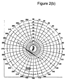
[0034] Figures 2a and 2b show a planar fracture classification example on a 2D
image display (Figure 2a) and stereonet plot (Figure 2b) (in normal
situations, the 2D image display is presented as a greyscale or colour
intensity image with defined features superposed in a different colour or
contrasting intensity; corresponding contrasting colours or intensities are
plotted for the same features on the stereonet image). In this example,
the segments plotted as light shading lines (see segments BB on Figures
2a and 2b) come from a pre-defined set of bed boundary features. This
illustrates how the proposed workflow makes it easier to highlight the rest
of events including fractures.
[0035] Figures 3a and 3b show a non-planar fracture classification example on
a
2D image display (Figure 3a) and stereonet plot (Figure 3b). It exhibits a
good case that what the traditional sinusoid based picking cannot
succeed. The segment-based approach of the present invention can
group and highlight these non-planar features, with the help of the
stereonet plot. For example, the grouped segments Fl, F2 and F3 of the
stereonet plot (Figure 3b) can be used to identify respectively to the
features FA, FB and FC of the 2D image (Figure 3a) which otherwise
CA 02697616 2010-02-24
WO 2009/026979 PCT/EP2008/005042
9/21
would be difficult or impossible to discriminate from other, unrelated
features of the image.
[0036] These two examples illustrate one level of a cleaning methodology. The
proposed invention allows multiple levels of classification steps in a
repeated manner by which the degree of unknowns, i.e. a number of
unclassified segments, is reducing and the problem solving is getting
easier and faster.
[0037] A number of algorithms can be used in the present invention, examples
of
which are discussed below.
[0038] Pre-processing algorithms, such as Susan's filter are discussed above.
[0039] For segment extraction, a number of criteria are available with choices
of
operations, including:
= Fractures (and other features of interest) may have very high intensity
or low intensity in the image compared to its neighbourhood
o Apply morphology operations to extract high intensity contrast
groups of pixels from the image.
= A feature of interest may have a minimum area (to remove the isolated
small group of pixels) and a maximum vertical thickness (vertical
extent)
o Label the connected groups of pixels and remove the small area
groups and the group, whose vertical extent is too high.
= A feature of interest may have a thin shape (e.g. fractures can be
modelled as a polygonal line/segment chain)
o Search polygonal lines (segment group) contained in each
feature, measure each segment thickness.
[0040] The basic segment extraction operations are based on a mathematical
morphology analysis of the image. Mathematical morphology is a non-
linear theory, which provides a tool for investigating geometric structure in
binary and greyscale images. Its objective is to analyze objects in the
image according to their shape, their size, their neighbourhood
relationship, and their grey scale values. The morphology analysis is
extremely efficient to solve problems which require shape analysis with
speed constraints.
CA 02697616 2010-02-24
WO 2009/026979 PCT/EP2008/005042
10/21
[0041] The morphology operations are first based on designing a structural
element with specific shape, size and origin. Erosion and dilation
operators can then be defined as the most elementary operators. Finally,
more complicated morphological operators can be designed by means of
combining erosions and dilations.
[0042] A pixel image can be defined as a function:
(i,j)E[l,nlx[1,m] -> I(i, j)E[O,AIAX].
where n is the row number, m the column number, and MAX the maximum
pixel value. For the purposes of this example a structural element B is
defined.
[0043] A dilation operator can be defined:
D(I)(i, j) = sup {I (i - x, i - y)}
(x,y)EB
[0044] Taking a disk as the structural element, the dilation operator has the
property to extend the size of the objects in accordance with the disk
diameter, to link objects whose separation is less than the disk diameter,
and to fill holes whose size is less than the disk diameter.
[0045] An erosion operator can be defined:
E(I)(i, j) = (xmfB{I(i-x,i- y)}
[0046] Again taking a disk shape as the structural element, the dilation
operator
has the property to decrease the size of the objects in accordance with the
disk diameter, to erase closely connected objects, whose size is less than
the disk diameter and to separate objects linked by an "isthmus", whose
thickness is less than the diameter.
[0047] An opening operator, comprising a combination of erosion and dilation
operators, can be defined:
O(I)(i, j) = (D E(I))(i, j)
[0048] Objects whose size is less than the structural element size are erased
and
excrescences which are too thin to contain the structural element are
suppressed. The size of the object is not reduced as this is the function of
the erosion operator.
[0049] A closing operator, comprising a combination of dilation and erosion
operators, is defined:
C(I)(i, j) = (E D(I ))(i, j)
CA 02697616 2010-02-24
WO 2009/026979 PCT/EP2008/005042
11/21
[0050] The closing operator fills holes whose size is less than the structural
element size and smoothes objects by adding points in thin concavities
(those which cannot contain the structural element).
[0051] An adapted operator for the automatic feature extraction for feature
characterisation purposes can be defined:
1 out (z, >) = I (i, J ) - min( I (1, > ), (0 - C(1))(i, J))
[0052] In a first step of an embodiment of the invention, a closing operation
is
used to fill the holes and link the high contrast features. In a second step,
an opening operation removes the small high contrast features. By taking
the minimum between the resulting image and the initial image, it is
possible to avoid artificially linked regions, which do not correspond to a
single geological feature. Extraction is then performed by computing the
residue between the resulting image and the initial image.
[0053] In the present invention, an adapted structural element is preferably
used.
In a general case, all the events in an image must be extracted.
[0054] Taking a vertical line as a basic structural element has certain
preferable
features:
= Images of the type addressed by the present invention are typically
made using a tool with an array of small, 'button' sensors (e.g.
electrodes) on a pad that is pressed against the borehole wall as the
tool is logged up the well. Therefore, a contrast measurement along a
vertical line can come from the same button sensor and so does not
suffer from calibration problems affecting measurements within that
element/line.
= As the geological events of interest are generally represented as a
function of the azimuth in a specific interval (straight line, or partial
sinusoid), extracting the points or at least thin features along the depth
gives one depth for one azimuth.
= In the case of intersecting geological events, the use of vertical
elements allows the event to be split into independent groups to avoid
mistakes in the grouping step (different geological events must belong
to distinct groups). The size of the structural element of interest is
CA 02697616 2010-02-24
WO 2009/026979 PCT/EP2008/005042
12/21
based on the maximum (vertical) thickness to be extracted from the
image. A default maximum thickness of ten pixels (corresponds to
2.5cm in the case of FMI image) is proposed but may be changed
according to the nature of the image and the measurement technique.
Elements above this thickness can be removed. Figure 4 shows an
image of two intersecting events indicated generally by lines X-X and
Y-Y. The central reqion Z formed b_v the intersectinn nf thP tWn ii-,oe
exceeds the maximum thickness and so is removed. Thus the sub-
elements relating to event X-X are separated from the events relating
to event Y-Y.
[0055] Structural elements can be chosen based on a priori information. The
basic structural element in the image is a line, whose slope depends on
various factors. By providing this a priori information, segments of specific
type can be extracted from the image:
= Where bedding dips have been previously identified, to remove the
bedding in the segment extraction step, the image is flattened and a
horizontal line used as structural element.
= Where segment orientations have been picked manually, and the user
wants to extract these orientations, each picked segment defines an
orientation and an azimuth interval. For each orientation, a line which
is perpendicular to this orientation is used. The morphology operations
are only applied on picked azimuth intervals. Each orientation gives
one output image. The single output image is the maximum of all the
output images.
= Where segment orientations have been picked manually, and the user
wants to extract segments other than these orientations, again each
picked segment defines an orientation and an azimuth interval. For
each orientation, a line which is parallel to this orientation is used. The
morphology operations are only applied on picked azimuth intervals.
Each orientation gives an output image. The single output image is the
maximum of all the output images.
[0056] For each case, the size of the structural element depends on the
fracture
maximum vertical thickness to be detected.
CA 02697616 2010-02-24
WO 2009/026979 PCT/EP2008/005042
13/21
[0057] At the end of this step a new binary output image is created. If the
background conductivity is given as a priori data, this is used as threshold
in order to build the binary image. Otherwise, the highest values of the
output image (typically 20 percent of the highest values) are selected as
the threshold.
[0058] To extract the low intensity contrast features, for example when
analysing
an image of conductive and restive fractures, the opposite (neqative)
image is computed and the same operations are used.
[0059] Representing and exporting the groups is based on the extraction of
polygonal lines from the image. The group is represented as a polygonal
line having specific properties:
= Pixel values: intensity distribution, variance; and
= For each segment in the group: index, length, orientation (for each
segment seen as a vector in the 3D space), thickness, and aperture.
[0060] This representation allows the user:
= To have very accurate statistics about the geological events and a
better analysis. The aperture is particularly suited to find eventual
azimuth anisotropy - influence of the drilling induced stress - or to
provide information about fracture type.
= To filter the group according to user-selected rules. Typically, the user
can apply a threshold on one of the previous properties to select the
groups of interest.
[0061] In order to extract the polygonal, two different processes are needed:
= a splitting strategy to divide the different pixel groups in several
straight
line groups; and
= a best fitting segment method to find the segment for each group
forming a straight line.
[0062] In order to build polygonal line, each group is divided into several
subgroups. One way to do this is to scan the object from left to right. A
part of the group is extracted as soon as this part has a length much
higher than the measured thickness (for example, when the length of the
part is exceeds 1.5 times the thickness). The measured thickness is the
CA 02697616 2010-02-24
WO 2009/026979 PCT/EP2008/005042
14/21
mean thickness of the group along the vertical direction. The length is the
Cartesian norm joining both extreme points.
[0063] Figure 5 shows an example of a polygonal group. The average thickness
of the group in the vertical direction (shown as individual measurements T
in Figure 5) is determined ('measured thickness'). The group is scanned
from left to right until a sub-group G1 is detected which exceeds the
measured thickness by the predetermined amount. The lenoth L is thP
distance between the extremities of this sub-group. The other sub-groups
G2 and G3 are similarly defined and together with G1 define the polygonal
line.
[0064] The preferred processing uses a robust best fitting segment algorithm
such as an M-estimator with a Tukey's biweight function (see J.W. Tukey,
Exploratory Data Analysis. Addison-Wesley, 1977; and S.Z. Li, Markov
Random Field - Modeling in Computer Vision, Springer-Veriag 1995,
Chapter 4. "Discontinuity-Adaptively Model and Robust Estimation"
(http://www.cbsr.ia.ac.cn/users/szli/MRF_Book/Chapter_4/node68. html))/
[0065] The robust best fitting segment can be very efficient in case of noisy
image such as that shown in Figure 6. In this image, a main straight line
group M has irregular image artefacts Al and A2 on one side. When
analysing this image using a non-robust best fitting segment, the group is
defined as the dashed line g. However, when using the robust best fitting
segment, the sub-group G is determined, ignoring the artefacts Al and A2.
[0066] The robust best fitting takes a maximum error as input (for classifying
into
inlier and outlier families): the thickness used in morphology operations is
taken as input parameter.
[0067] Figure 7 illustrates the final result. The morphology operations has
selected the objects 1- 7. Among these, the objects 1 and 4 are rejected
from consideration as failing the minimum area test. Object 3 is rejected
as failing the maximum thickness test. This leaves objects 2, 5, 6 and 7
as potential building blocks, i.e. segments, for grouping and classification.
The object 7 is further divided into 7a and 7b.
[0068] After extracting the segments from the image, next step is to group and
classify them as fractures and other geological objects. A cleaning
CA 02697616 2010-02-24
WO 2009/026979 PCT/EP2008/005042
15/21
methodology can be used to extract the fractures and other features by
switching between coarse and fine analysis and applying rules to
distinguish and finally pick the following main groups of events from the
image:
= Breakouts
= Induced fractures (non-planar)
= Bedding (planar)
= Natural fractures (full or partial plane)
= Other isolated fractures (mostly non-planar)
[0069] Beddings normally have well defined shapes, i.e. sinusoids, and are
first
extracted or may be pre-identified (a priori data) before the analysis
described above is applied. Although breakouts and induced fractures do
not have well defined shapes, they are relatively easy to distinguish from
other events. Therefore, if their presence is obvious, the segments
belonging to these types are next targets to be grouped and classified by
this procedure.
[0070] The remaining events in the image are either fractures or unexploitable
events and may require the final judgment by the user.
[0071] The present invention provides the tools that allow the user to perform
the
cleaning process more quickly. With reliable dip picking software (for
example using Hough Transform-based semi-automatic sinusoid picking)
the bedding can be used as a priori information.
[0072] By representing the segments in 2D image and stereonet view at the
same time, the complementarity of these representations is exploited in
order to improve the diagnosis. The stereonet view is a useful tool for the
geologist: it offers a synthetic orientation distribution display and
consequently a new means to extract interesting events in the borehole
images.
[0073] Table 1 below summarises how we can recognize feature types in both 2D
image and stereonet view, for different type of events.
Table 1
Family Name Event Geometry on 2D Image Geometry on
Type Stereonet
CA 02697616 2010-02-24
WO 2009/026979 PCT/EP2008/005042
16/21
Heterogeneity Unknown Segment Point
Sedimentary Surface Bedding Segments with sinusoid shape Points with great
circle shape
Planar Fracture Fracture Segments with sinusoid shape Points with great
circle shape
Partial Planar Fracture Fracture Segments with partial sinusoid Points with
partial
shape great circle shape
Non Planar Fracture Fracture Segments with no specific shape Points with no
specific shape
Induced Fracture Fracture Segments with same orientation Points concentrated
in a small area
[0074] The present invention preferably utilises six basic algorithms to
compute
the various attributed of the features of interest.
Algorithm 1: computation of the best fit plane (segment as input(s))
[0075] The present invention provides a tool which takes into account the
uncertainty along the vertical axis (thickness). Each segment has two
extremity points. Considering that any vector joining one input point to
another input point belongs to the best fit plane, the 80% highest dip
couples are taken and a robust estimator with Tukey's biweight function
applied to find the best plane orientation. Removing the outlier vectors
and knowing the orientation of the plane, the depth for each remaining
point is computed and the mean taken as plane depth.
Algorithm 2: search similar orientation segment (for segment(s) input)
[0076] For given segment(s), all the segments parallel or near parallel to the
input
segment can be searched by evaluating and analysing the scalar product.
This algorithm is useful in the case where the induced fractures need to be
easily removed.
Algorithm 3: search similar orientation segment (for plane input)
[0077] For given segment(s), all the segments parallel or near parallel to the
input
segment can be searched by dividing the input plane into several
segments and applying the previous algorithm. This algorithm is useful in
the case bedding needs to be removed easily.
Algorithm 4: Search similar orientation best fit plane (for segment(s) input)
[0078] For given segment(s), a tracking algorithm is applied:
CA 02697616 2010-02-24
WO 2009/026979 PCT/EP2008/005042
17/21
= The track starts with the input segment(s) and the algorithm
progressively finds segment(s) feeding the track
= A sinusoid model is used, Algorithm 1 being used to compute the
sinusoids
= A new definition is made of the error between a sinusoid and a
segment.
[0079] A tree with the most likely tracks is then built. Finally, the best
trar_.k is
selected as an output.
Algorithm 5: search for similar planes (planes as input)
[0080] First, select the segments with same orientation as the input plane
(Algorithm 3). For each segment, a probability of taking part of the plane is
computed (Gaussian distribution over difference angle between input
plane and segment).
For a given plane orientation, only the depth is missing to define the plane.
A depth is computed for each selected segment (for both extremities of the
segment the depth is computed and then the mean of both depths is
computed). In the case of a group of segment, the resulting depth is the
normalized weighted sum of each segment contained in the group (the
weight corresponds to the probability of taking part of the plane).
In the next step, the segments are clustered according to their depth. Only
the clusters with the highest azimuthal coverage are selected. Finally, the
best fit plane is computed for each selected cluster (Algorithm 1).
Algorithm 6: search for similar planes (nothing as input)
[0081] If there is no input, the algorithm finds the best orientation, using
the
vector rather than the segment representation. The robust best fit plane is
used, which gives as output the best orientation and the outliers. The
previous algorithm with this best orientation as input is then used.
[0082] This is closer to the way how geologists analyze geological features on
borehole images.
[0083] Figure 8 shows a system for carrying out the invention according to one
embodiment. Specifically, there is shown a borehole 82 drilled downhole
into the ground. A scanning or imaging tool 80 is moveably located
downhole for scanning the surrounding formation. It should be understood
CA 02697616 2010-02-24
WO 2009/026979 PCT/EP2008/005042
18/21
that the imaging tool could form part of a standalone sonde device or
could form part of a drill collar apparatus (not shown), which apart from
drilling has various other sensors and control for carrying out other
operations. The imaging tool 80 is able to scan 86 the formation 84 and to
recover data of the formation which contributes to an image of that
formation. It should be appreciated that said image data can either be
processed downhole or within the imaaina toni 8n nr on tnA si;;-f4co ,=,~~-~
V, tI1GIG
it can be stored in a memory device 87.
[0084] The memory 87 can store data or indeed a plurality of algorithms (best-
fit)
that can be accessed and used by a processing unit 88. A user 91 is able
to interact with the system via an I/O device 89, such as a display for
viewing the image and a keyboard for selecting various parameters and
algorithms for interacting with the display and rendering of the image.
[0085] It should also be appreciated that although a wire link 90 is shown
between the imaging tool 80 and the storage unit, there could be a
wireless connection with the surface, for example mud telemetry.
Moreover, the I/O device 89, processing unit 88 and storage unit 87 all
represent functionality that may be distributed or grouped into a single
device, i.e. surface PC, or hardware module integrated downhole within
the image tool 80 itself.