Note: Descriptions are shown in the official language in which they were submitted.
CA 02709377 2010-06-14
WO 2009/086158 PCT/US2008/087765
......... -..... --
REMfOTE> SENSING AND P[tO]3.ABIl..ISI.[C SAMIMPI.:ING1.13. SE:.:f) "
:'l'l:[t=Tl3 FOR
DETERMINING THE CARBON DIOXIDE VOLUME OF A. FOREST
B C GROUND
---------------------------------------------
T.he remote sensing and probabilistic sampling based method for determining
the
carbon dioxide volume of a, forest relates generally to analyzing remote
sensing data, such as
digital images and LiDAR data, to extract, classify; and analyze aggregate and
individual
features, such as trees in order to produce an accurate forest inventory More
particularly., the
remote sensing and probabilistic sampling based r rethod for determining the
carbon dioxide
volume of a. forest relates to a method for producing an accurate
determination of the amount of
carbon dioxide volume per acre of the forest.
The importance of calculating carbon sequestration in lbrestland is important
for a
variety of reasons. -Deforestation is estimated to be responsible for 20-25%
of the world's
greenhouse gas emissions (IPCC 2001), including carbon dioxide (CO2). The
ability to calculate
baseline forested carbon stocks as well as monitor change over time with
statistical precision and
accuracy is critical to understanding advancements or declines in
sequestration efforts in the
United States and around the world.
The probabilistic sampling forest inventory method of collecting quantifiable
inputs for the accurate calculation of carbon stocks can provide a significant
advancement in
carbon sequestration Ãrr.easurement and monitoring of -forested carbon stocks.
This advancement
is important in potentially reducing the cost of data input collection as well
as the ability to
systematically process the inputs for calculations of potentially billions of
acres d ith statistical.
precision and accuracy unmatched heretofore
.
SUM MA.[RY
An embodiment of a remote seising and probabilistic sampling based method for
determining, the carbon dioxide volume of a forest as described herein can
generally comprise
=1-
CA 02709377 2010-06-14
WO 2009/086158 PCT/US2008/087765
processing remote sensing data which is indicative of tree attribute
information; defining a
sampling frame within the remote sensing data; determining a field plot
corresponding to said
sampling frame and collecting field plot data therefrom, said field plot data
comprising actual
tree attribute information; creating a regression formula using the correlated
tree match database
and the remote sensing data from the sampling frame; generating a correlated
model using the
regression formula; applying the correlated model to all remote sensing data
to create all accurate
forest inventory; and determining the probabilistic carbon dioxide volume per
acre of the forest.
The remote sensing data can comprise LiDAR data, digital im.agesÃ, and/or
property boundary information, and the tree attribute information can be tree
height, diameter,
and/or species. The field plot data can be actual, measured tree attribute
information. The field
plot data can be obtained via precise physical measurements of trees on the -
round, and the field
plot can be matched to the sampling frame using, for example, a highly
accurate Geographical
l
Information S stem (" (iIS") to ensure that the sampling frame matches up with
the field plot
where the field data is me:a.sured.
Generation of the correlated model can further comprise verifying the accuracy
and./or the quality of the correlated model. Verifying the accuracy of the
correlated model can
comprise comparing the field plot against the model prediction. Verifying the
quality of the
correlated model can comprise rising quality control means including checking
and ensuring that
there are no calculation errors..
Basically, the remote sensing and probabilistic sampling based forest
inventory
method described herein can generally comprise the use of probabilistic
sampling based methods
to accurately capture forest inventory. The remote sensing data can be aerial
data. such as the
aforementioned liDAR. data and digital images, e ,g., color infrared spectral
("CIR")
photography, and/or multispectral photography. Also, hype:rspectral. data can
be used instead of
n'rrrl.tispectral or C IR. data. Via a sampling fi me and corresponding field
plot, the remote
sensing data can be correlated with actual sampled and measured field data to
obtain (predict) an
-2-
CA 02709377 2010-06-14
WO 2009/086158 PCT/US2008/087765
accurate forest inventory. The resulting tree inventory can represent an
empirical descliption of
tree attributes, such as height., diameter breast height (' D H") and species
for ever- tree within
the selected inventory, area. This data can be utilized to create an accurate
forest inventor and
then determine the carbon dioxide volume per acre of the forest.
BRIEF DESCRIPTION OF THE :DRAWI G FIGURES
FIG. I is a high level diagrr.m of an embodiment of a remote sensing and
probabilistic sampling based forest inventory method.
FIG. 2 is a high level diagram of an embodiment of a field data correlation
method.
FIG. 3 is a. high level diagram of an embodiment of a correlated model
generation
method.
FIG. 4 is a high level diagram of another errrbodiment of a remote sensin ;
and
probabilistic sampling based forest inventory method.
FIG. 5 is a lower level diagram ofan embodiment of an ima=gery data processing
method as illustrated in FIG. 4.
FIG. 6 is a lower level dia4>ram of an embodiment of a tree polygon
classification
method as illustrated in FIG, 4.
FIG. 7 is a lower level diagram of an embodiment of a field data correlation.
method as illustrated in FIG. 4.
FIG. 8 is a lower level diagram of an embodiment of a correlated model
generation method as illustrated in FIG. d.
FIG. 9 is a lower level diagram of an embodiment of a probabilistic inventory
generation method as illustrated in FIG. 4.
FIG. 10 is a lower level diagram of an embodiment of a probabilistic inventory
generation method for the calculation of carbon volume as illustrated in FIG.
4.
FiG. I 1 is a schematic. diagram illustrating the steps of an embodiment of a
-3-
CA 02709377 2010-06-14
WO 2009/086158 PCT/US2008/087765
method of feature. identification and analysis.
FIG. 1 2 is a digitized input image with a 2-4 meter/pixel resolution
illustrating a
12 square mile forested area in Nicholas County, West Virginia.
FIG. 13 is a flow chart of tre step of l riglr level segmentation of tree
stands from a
digital input image.
FIG. 14 illustrates an ex r rple of a digital image output using a computer
video
rnà miter, overlaid with. the polygon image produced by the step of high level
tree stand
segmentation.
FIG. 15 illustrates the same input image as FIG. 4, after unsupervised stand
segmentation adjustment.
FIG. 16 illustrates r .ranual stand segmentation adjustment by circumscribing
a line
through tree stand segment polygon borders, such that the portion of the
polygon circunmscribed
is removed from the segmentation image and file.
FIG. 17 illustrates the result. of rrm.anual segmentation adjustment on FIG.
6.
FIG. 18 is a flow chart of low level tree crown segmentation.
FIG. 19 illustrates user selection of a stand vector file for tree crown
delineation,
species classification, and data analysis.
FIG. 20 illustrates the selected stand vector file before low level
segmentation.
FIG. 21 illustrates low level tree crown segmentation using control
parameters.
FIG. 22 is a species classification flow chart.
FIG. 23 illustrates a training procedure used in supervised tree crown Species
classification.
FIG. 24 illustrates computer assisted classification of unselected trees based
on a
training procedure and user selected training units-
FIG. 25 is a data analysis flow chart.
FIG. 26 illustrates a video monitor- displayed data and image file containing
data.
-4-
CA 02709377 2010-06-14
WO 2009/086158 PCT/US2008/087765
analysis results.
DETAILED DESCRIPTIONOF CER I A:FNEMBODINIEN T:S
A remote sensing and probabilistic sampling based method for determinin the
carbon dioxide volume of a, forest is described in detail hereinafter. In the
f l.lowingg description,
for purposes of explaraaa:tion, numerous specific details of exemplary
embodurtent.s are set forth in
order to provide a thorough understanding of the remote sensing and
probabilistic sampling
based forest inventory method. However, it may be evident to one skilled in
the art that the
presently described method may be practiced without these specific details.
The method can be
most suitably perfonned using a computer system, e.g.. a processor, storage
media, input device,
video display, and the like,
The terms ` carbon' and "carbon volume. ` as used herein are used
interchangeably
with "carbon dioxide" and "carbon dioxide volume' and are used in the context
of determining
the amount of carbon, or carbon dioxide, which is sequestered in a subject
forest.
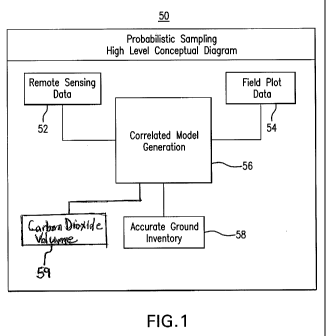
Probabilistic Design-Conceptual Level
The probabilistic sampling method described herein is based upon. remote
sernsingg
data that Is blended with field plot data and used to create a correlated
model, and is represented
at the conceptual level in FICIS. 1 through 3. A high level diagram of an
exemplary embodiment
of a remote sensing and probabilistic sampling based forest inventory method
50 is illustrated in
116. 1, which can generally comprise Utilizing remotely sensed data 52 in
combination with field
plot data 54 to generate a correlated model 56 which can be utilized both to
create a1110re
accurate forest (ground) inventory 58 and to determine the carbon dioxide
volume. 59 of the
forest. The remote sensing data. 52 can be indicative of tree attribute
information for the forest,
and frorn this data one or more sample frames can be defined for subsequent
use in creating the
probabilistic sampling based forest inventory 58. The remote, sensing data 52.
can comprise
aerial data, such as LiDAR data, digital. images, arid/ ar property boundary
information. The
digital images can include OR, multi spectral and/or hyperspectral
photography. Multispectral
-5-
CA 02709377 2010-06-14
WO 2009/086158 PCT/US2008/087765
imagery can contain about 3-10 channels. Generally, hyperspectral imager(
contains hundreds
of bands for each pixel and has typically much larger pixel sizes than can be
required according
to the embodiments of the methods described herein . Nevertheless, h-
perspectral imagery could
potentially be utilized.
Field Data Correlation
The field plot data. 54 can be obtained via precise physical measurements of
trees
on the (ground, wherein the field plot 60 is matched to the sampling frame (or
vice versa) using,
for exanmple, a highly accurate geographical information system (GIS) to
ensure that the
sampling frame matches up with the field plot 60 where the field data 54 is
being measured.
One, or multiple, sampling frames (ww hich can be randomly selected) and
corresponding field
plots can. be utilized. A. set of correlated feld plots can create a set of
geo-referenced points.,
each aattii.buted with a tree's data. Taken over a range of random samples,
these plots 60 can be
classified as unbiased by a forest biometrician. "U.abiased" sampling
methodology is critical to a
forest ins, entory= in the same way that GA-AP (Generally Accepted .Accounting
Principles) is
critical in the analysis of financial performance of corporate entities. Any
bias introduced in the
sampling methodology makes all measurement results suspect.
FIG. 2 is a diagram of an embodiment of a correlation process to manipulate
the
field plot data 54, which process can generally comprise determining a. sample
field plot 60,
collecting field plot data 54 therefrom, and then. utilizing the data, The
field plot 60 can
correspond to a sampling frame defined from the remote sensing data 52.
Alternatively, the field
plot 60 can be selected first, and a sampling frame from the remote sensing
data 52 can be
deflated which corresponds to tlhe selected field Blot. Whichever the case,
the idea is to correlate
remote sensing data 52 to actual field plot data 54 in order to create a
correlated model (e.g.,
regression formulas and associated coefficients, as described hereinafter in
more detail) This
correlated model can then be applied to all of the remote sensing data 52 to
produce a more
accurate, probabilistic sampling based forest inventory 58, and also to
determine the carbon
- 6 -
CA 02709377 2010-06-14
WO 2009/086158 PCT/US2008/087765
dioxide volume 59 of the forest.
The field plot data 54 can further comprise actual field attributes 62 and
field plot
measurement data 66. The field attributes can include tree attributes such as
tree species, tree
diameter and tree height, which can be used to create a correlated tree a
catch database 64. The
field data correlation process can include plot center location correction 68
to ensure the field
plot 60 accurately corresponds to the associated sampling frarrae.
Correlated Nlodel Generation
Referring more particularly to FIG. .3, the remote sensing data. 52 and field
plot
data 54 can be combined to generate a correlation model 56 which can be
comprised of formulas,
e:,g., for tree species, height, and diameter, and can also include
verifications of facts and
relationships between stand data, strata data, plot data, plot-tree data, and
plot-tree-polygon data.,
as would be understood by one of ordinary skill in the art, and as may be
discerned from the
detailed description which follows hereinafter.
A stand is a group of trees that, because of their similar age, condition,
past
management history, and/or soil characteristics, are logically managed
together. Stratification
(creating strata) is the process of aggregating the forest into units of
reduced variability, Plots
are small areas selected in stands, where field measurements are made. Plot
tree-polygon data is
the data. about tree polygons created for stands that happen to be inside
these plots.
The correlated model generation 56 can comprise correlating 74 the remote
C~l
sensing data 52 and the field plot data 54 (via the correlated tree match
database 64) in order to
derive formulas 76, e.g,, regression formulas, and associated coefficients,
for tree species, tree
hei4ght, and tree diameter. The correlated model 56 can then be applied to all
remote sensing data
52 to produce an accurate, probabilistic sampling based forest inventory 58,
The resulting
inventory 58 can represent an. empirical description of tree attributes, such
as species, height, and
diameter breast height ("D1111") for every tree within the selected inventory
area. This also
enables an accurate determination of the carbon dioxide volume 59 of the -
forest.
-7-
CA 02709377 2010-06-14
WO 2009/086158 PCT/US2008/087765
Generation of the correlated model 56 can further comprise veri-(yinfy the
accuracy
70 and/or the quality 72 of the correlated model 56. Model accuracy 70 can be
verified by
comparing the DBH, as well as the height, volume, and stem number values (as
measured on the
field plot 60) against what the. model predicts these numbers should be for
the exact same areas.
Additionally, specially? designed "control plots" could be used in a, model
veritcation process.
Next, statistical estimates based on these two different plot inventory sets
can be calculated and
analyzed. Model quality 72 can be verified using quality control means, which
can comprise
procedures to check and ensure. that there= are no calculation errors in the
models being utilized.
In general, model q ality can be related to model accuracy,
Overview and Examples
LiDAR. and fntaltispectral imam ery, for example CIR photography, could be
used
separately, but in preferred embodiments are used together to .identify and
characterize individual
tree crowns. Operationally, it is feasible to collect data for entire forests,
and to construct digital
maps with stand boundaries and with polygons representing tree crowns.
Techniques to create
crown polygons, assign species and impute tree sizes are the sulject of many
ongoing research
efforts in Scandinavia, the United States, and elsewhere.
A starting point for saannpling can be a map with crown polygons attributed
with
species and possibly LiDAR .height; which can be used as a sampling frame for
a statistically
valid .forest inventory 58. The sample design might. assign the stands to
strata, randomly select,
stands for sampling, and might randomly choose two or more map coordinate
locations within
the selected stand polygons to sere-e, as plot centers (for sampling frames)
to obtain field plot data
to correlate to the sampling frames.
Fixed-area field plots 50 can be installed at these selected locations
(sampling
frames). Departures from conventional inventor procedures are that the plot 60
is centered as
close as is technologically feasible to the pre-selected coordinates, and the
plot 60 is stem-
snapped. A fixed-area image plot is identified in the sample .frame and co-
located with the
-8-
CA 02709377 2010-06-14
WO 2009/086158 PCT/US2008/087765
aground/field plot. The feld trees and crown polygons are matched. Models are
then fit, or
calibrated, to predict what the individual crown. polygons actually represent
in terms Of tree
counts, species, DBH's and tree heights. These models can be approximately
unbiased for basal
area and tree count by species at the strata level. Field trees that are not
matched to crown
polygons are modeled separately, The models are applied to the sample frame so
as to estimate
the entire forest inventory 58; the predicted trees are summed by stand to
create stand tables.
This data further enables an accurate determination of the carbon dioxide
volume 59 of the
forest. The modeling strategies, and the methods for handling plot co-
location, tree and crown
polygon matching, and stand boundary overlap all present interesting
challenges, which are
addressed by the present method, are described in more detail belovv.
More particularly, embodiments oftl the correlation of the remote sensing data
52
and the field plot data 54 c rri further comprise one or more of the
.{rsllotai =õ step :
measuring the field plot center using a survey grade (}PS device.
= saving the tree species, height and DBH information for all trees in the
plot.
= measuring the distance to the plot center and azimuth.
= adding relative tree locations to the GPS locations, and displaying these
absolute
locations overlaid on aerial digital and Li DR imager,
= field crews correcting the field plot center location to a location that
results in the best
match between tree locations on the digital arid!
o r l: ii AR imagery and the locations
measured in the field
= using a tree recognition algorid un to detect objects. i.e., tree polygorns,
on the digital
and/'or LO) AR- iÃnagery.- optimally (but not necessarily) these objects
correspond to
individual trees.
= calculating tree polygons attributes, Li DAR height estinarates, area, color
(on SIR
irriagery,), and/'or estimated tree species.
= tree polygon objects located in the plot areas are extracted from the data
and used for
the procedures described below, matching and/or statistical analysis.
= Using automatic field tree matching to create a table in which measured
field tree
records are merged with tree polygon objects based upon geographic proximity.
__-itching described above based upon interpreter estimate
~ 9 -
CA 02709377 2010-06-14
WO 2009/086158 PCT/US2008/087765
that current field tree is either contributing to some pixels of the tree
polygon that was
created or it is not visible from air because of a IaÃger= tree that
contributed all or some
pixels of the tree polygon-
= usingg statistical analysis for the data set of field trees, tree polygon
objects and/or the
relations created in the two preceding steps.
= the prediction estimates, e.g., the probabilities that tree polygons
correspond to 0,I,^,
,.. trees, the probabilities for tree species for these trees; and the
probabilities for
DBH and height for these predicted trees
= the prediction can also estimate the number of trees "not seen," i.e., which
have no
correlation vN"ith the tree polygons.
= applying these predictions, obtained using the data for field plot areas, on
polygons
over the entire inventoiy area (an example of probabilistic sampling based
predictions
is provided hereinafter).
for predicted tree DBH and height values, using appropriate models to predict
the
volumes, and then aggregating these values to create a stand level inventory.
Referring back to FIG is, specifically block 76, according to a probabilistic
sampling based method, this part. of the process can comprise more than a.
single estimate for
determinations such as, for example, how many trees there might be and what
might be the
species of the (largest.) tree corresponding to the tree polygons. "These
alternative events can be
assigned probabilities, and the final DBH and volume estimates can be based
upon summing tip
the DI311T and volume estimates for these events, vn4tlr their probabilities
to take into account.
Model accuracy 70 can be verified by comparing the I).BH,, as well as the
height,
volume, and stem number values (as measured on the field plots) against what
the model predicts
these numbers should be for the exact same areas. Additionally, specially
designed "control
plots"' could be used in a r yodel verification process. Next, statistical
estimates based on these
two different plot inventory sets can be calculated and analyzed.
Model quality 72 can be verified using quality control means, which can
comprise
procedures to check and ensure that there are no calculation errors in the
models being util zed.
In general., model quality can be related to model accuracy,
CA 02709377 2010-06-14
WO 2009/086158 PCT/US2008/087765
Example of Probabilistic Sarnplin.g:[Based Predictions:
The data contained in the tree match database 64 is used to predict the stem
count, DBH, basal area., total height and volume estimates for all stands,
which can be used to
calculate the carbon dioxide volume of the forest. The estimates are based on
probability t1. eory~
and estimating the probabilities of several conditional events. These events
(referred to herein as
tree record sequences or TRS) are saved into the database. Separate DB1-1,
height, and volume
r yodels are created for separate TRS events.
The following is an example of a TRS table corresponding to a single polygon:
E ( C )
Description 1 Single Tree 1 Pr C= 11 x Pr SG=1 C=1
2 SirAle Tree 2 --Pr (C m 11 x 1 - Pr.. G=1 C=
3 Lar er of (1j) I PrfC = 21 x Pr species= 1 1 C
4 Smaller of (1,1) 1 PrfC = 21 x Pr species= 1 1{ C = 2
Lar er of (1,2) 1 Pr IC m 2 x Pr spe es= 1,2) C 2
6 Smaller of (1,2) 2 PrfC 21 x Pr species=(12) C Z-jk
7 Larger of:2,1 2 Pr-IC= 21 xPr species=(21 C=2.
8 Smaller of 2,1) 1 Pr C= 2 x Pr species=t;2,1) C. 2
9 Larger of 22 2 PrfC=2 x Pr species=(2.2 C=2
Smaller of 2,2) 2 PrfC = 2 - x Pr species=(2 2 C = 21
11 Tertiary Conifer 1 PrfC. = 3 x E{C for P >= 3, SG=1 C = 3
12 Tema Hardwood 2 PrfC = S x EfC for P >= 3 SG=21 C = 3
The input variables used for analysis are polygon area (A) and the polygon
height
calculated from the LIDAR data (H). Also, species group predictions (S) was
used, which was
calculated from CIR imagery. For purposes ofthis example, only -1 species
groups are used,
nary ely -- hard vood and conifer.
For all tree record sequence events, the .following variables are calculated-
= E(C) or estimated count,
= the species group (SG),
= DBH,
= total height of the tree, and
= the volume of the tree,
vnri:gbles of the prediction equations. The following example
-11õ
CA 02709377 2010-06-14
WO 2009/086158 PCT/US2008/087765
illustrates a, manner of predicting all tree sequence values for tree polygon
objects, using a
regression analysis:
Estimated counts for `RS events are predicted for continuous values of A, H
and the discrete values of S:
Prediction formula for the probability, Pr (C `= 1) is estimated for
continuous values of A H and discrete values of S
Prediction formula for the probability Pr( C>= 2 ; C >= 1) depending
on A , H and S. The ' denotes the conditional probability.
Prediction formula for the probability Pr ( C>W 3 1 C >= 2) , depending
on A,HandS
. Estimated tree specie groups for TRS events depend on position of the tree
(P). The largest tree of the polygon has the P value 1, the second largest 2
and
so on, `Ã'l e probability of the largest tree specie group was
Prediction formula t r Pr SG I for 1' 1.1 C 1 ]
o Prediction formula :l"or Pry SG 1 for P 2 ; C 2 3
Prediction formula for Pr? SG :::1 for P 2 C:::: 2, SG:::: I for
a Prediction formula for Pr i SG= I for P = 2 C 2'. SG = 2 for P = 1)
= Estimated counts for tertiary trees as follows.-
1'redi cti on for .E C for P - 3 1 C = 3
Estimated DBH values
Prediction for DBH(A., 11 SG::: 1 ., P -==1.)
o Prediction for.DBH(.A : H SG = 2. P = 1.)
Prediction for Dt3 H.(A,1-1 SG 1, P ="2)
Prediction for I3:1B11(-.. I1 SG::: 2. P:::: 2)
= Estimated height values
PredictioÃi f o r HT(A, .H SO = 1 ]',
Prediction for FIT(A, Fl SG::: 2]:
= Volume equations
Volume equations are not predicted. Instead, standard equations for
the forest type are used to calculate volume from tree breast height
diameter and total height values,
.tiOil S
-12õ
CA 02709377 2010-06-14
WO 2009/086158 PCT/US2008/087765
Carbon Weight ecluuations are also not predicted. Instead, Standard
equations for species are used to calculate tree biomass, abov=e ground
carbon values, and root carbon values using. previously determined
tree breast height diameter and total height values.
Prediction Formula Example:
Pr{C= I: = 11(1 +exp(c(;+cuxA+c, H c._} :X A*H))
In this equation, the coefficients,, Cu th:rouup
~h c:;,, can be approximately 2.4 , _.
0,04 3, -0.0508 and, 0.00044, respectively.
Using the described predictions, estimated counts, diameters, heights, and
volumes for all tree record sequences can be calculated. By summing cup these
results over all of
the polygons in the stands, a more accurate stern count, basal area, and
volume estirna.te.ttur
whole stands can be calculated.
Referring now to the diagrams in FIGS. 4 through 9, a further embodiment of a
remote sensing and probabilistic sampling based method for determining the
carbon dioxide
volume of a forest 100 is illustrated, which can generally comprise processing
imagery data 10;3
(which data. is indicative of at least tree attribute information);
classifying tree polygons 106
within the imagery data to derive the tree attribute in:tbrniation (wherein
the tree attribute
information can be a number of trees indicated by the imagery data);
correlating field data to the
imagery data 109 (which correlating can comprise defining a. sampling frame
within the imagery
data), collecting field data fromi a field plot determined to correspond to
the sampling frame,
wherein the field data comprises actual tree attribute information); creating
a correlated model 1122 by matching the tree attribute information derived
from the im:a{geu y data with the actual tree
attribute information from the field data; probabilistic inventory creation
115 118, which can
comprise extracting a regression formula. using the correlated model and then
applying the
regression formula to all of the imagery data to produce in accurate inventory
for the forest; and
to then calculate a corresponding carbon dioxide volume of the forest,
13
CA 02709377 2010-06-14
WO 2009/086158 PCT/US2008/087765
Generally, the imagery data processing 103 can comprise polygon fusing and
color 127, Li DAR processing 130, and CIR processing 133, The tree polygon
classification 106
can generally comprise creating a training set 136, creating a sample plan
139, and creating tree
crown polygon 142. The field data correlation 109 can generally comprise
creating polygon
match files 145, fixing the plot center 148, sample plot attributes 151. The
correlated model
generation 112' c ii basically comprise creatin ; a species probability
prediction model 154, a
diameter probability prediction model 157 and the height probability
prediction model 160. The
probabilistic inventory creation 1 15/118 can generally comprise a plotting
and regression
formula to all tree crown data 163, providing an accuracy= statement 166 and
updating customers'
original stand inventory data 169, This data can then be utilized to calculate
the carbon dioxide
volume 172 of the .f orest.
The determination of the carbon dioxide volume of the forest can ( enerallyy
involve applying known equations to the previously determined forest inventory
data to
determine the carbon dioxide volume per acre of the forest. The manner of
determining the
carbon dioxide volume can generally comprise applying known equations. to
convert the stern
volume (in the case of above ground carbon volume) to carbon dioxide volume.
Examples of
physical data calculations to determine tree volume and corresponding carbon
dioxide volume
are:
I an eÃel brews ire#_g1 -= (6.04 3*s rt ,'~ ))
g
`free Height dig(( , A),((2,09000+(0.14050'A))*(2,090010 (0,14050 `A))) +
130000..
tt_nr Yt h_rrnie = 0 02292 *pow(A,1.91505)"powi0.9 l46,:A)'
pow(B,2.82541)*pow((B-
1.3 ),-1.53547).
Above Ground Carbon Volume W exp(4.938 -4.. 2,406 og(D))/'2000000.
Root Carbon Volume Root carbon 0.2 " _ bove Ground Carbon Volul-ne.
(1. ~ tree crown area, B ~ predicted tree height, and D) diameter breast
height)
Accordingly>, the carbon volume equations penrit a very accurate calculation
of
1
CA 02709377 2010-06-14
WO 2009/086158 PCT/US2008/087765
carbon dioxide volume per acre of lie forest. based upon the forest inventory
data. acquired by
the probabilistic sampling method,
Turning now to Fly. the digital imager, data processing 103 can further
comprise ClRJJStand Line Processing 1721 and LiDAR processing 175. The data
input to the
CI:RJStand Line Processing 172 can comprise C JR photography 179, stard shapes
18 1., and
customer property boundary information 184. alternatively, instead of, or in
addition to, OR
photography, the digital images can be multispectral and/or hyperspectral. The
stand shapes
(and/or tree crown polygon shapes) can be derived from a the it a.ger data i.r
put. The data input
to the.Lil AR processing 175 can comprise OEM (Digital Elevation nmodel)
information 187 and
raw LiDAR data 190,
As illustrated, the color infrared/stand line processing 172 can comprise
multiple
steps, including one or more of the fallowing:
A reading the input data 1.78;
B splitting the CIR inaFery and stand lines into smaller blocks, which can be
saved in,, for example, a split block data set 193 and smaller block files,
196;
C morphological openin ; and smoothing to create a smoothed block data set
4,99:
D stand fixing/photo interp:re ation;
E shape clipping, which can be saved as clipped shape files 20221-
F merging small blocks into one property tile.;
G quality, control and inheritance; and then
11 stratification, after which data can be saved as final property files 205.
Creating the smoothed block data set 199 can comprise rasterizing the stand
boundaries to remove all possible topology errors and features below a certain
size that .a be
present in original stand boundaries. Afterwards, the morphological opening
can be applied to
the rasterized stand neap,, followed b v vectorizing the stand shape again,
generalizing and
CA 02709377 2010-06-14
WO 2009/086158 PCT/US2008/087765
smoothing the shape and finally clipping the boundaries to the property
boundaries.
As further illustrated, the LiD 1:R processing 175 can also Comprise multiple
steps, including one or more of the following:
l calculate :DIM (digital terrain model.) and saving import attributes 208;
J select highest pixel and subtract :OEM (digital elevation model);
K map digital surface value to 8 bit integer,
L convert and save data. to gray scale, and the LiDAR metadata and attributes
21.1 can be saved, as can gray scale biti-nap image files 214.
Generally, the Li DAR processing can comprise calculating the. E;! ; selecting
highest pixel and subtracting DEM; r napping, digital surface value'.. and
converting the data to
gray-scale. The laser scanning data. provides a geo-referenced point cloud
about earth's surface,
DENT, which can include f :atures li ;.e vegetation and buildings. The .D"I'M
carn be calculated as a
filtered version of Ã3E' 1, and may contain only points classified as the
"4ground." Both DE'tM1 and
DT.M values are then calculated for some grid (for example 0.5 x 0.5 meter
grid or 1.5 x 1.5 foot
tgrid). l:f i core than orie DFIM point hits one grid cell, the highest one is
selected. If no [3[.:1 1:
points hit the grid, the values are interpolated using nearest points. A .D M
(digital surface
model) is then calculated as the difference between the 13F-A4 grid and DTM1
grid. After that, the
continues values of DIM grid are replaced with discreet digital numbers
between 0 and 255, and
the results are saved as 8-bit grayscale bitrrrap .files.
FIG. 6 illustrates further details of the tree polygon classification 106,
which can
comprise superimposing input data, such as at least one of CIR photography
217, or
multi spectral. photography, stand shapes 220, tree crown polygon shapes 2223
and :LiD.AR data
226. The process 106 can further comprise multiple steps, including one or
more of the
following:
A superimpose data sets and shift polygons, and a polygon shift dataset 229
can
be saved-,
1b
CA 02709377 2010-06-14
WO 2009/086158 PCT/US2008/087765
13 manual review species strata., wherein a species strata excel report 232
and
species strata data set 235 can be created::
C calculate average color-infrared bared for individual tree crowns-,
I) calculate second order gray level texture feature;
F selecting a subset of stands for classification, which can be saved as
selected
stands file 238;
F create training set for species at strata level, which can be saved as a
training
data sot per strata 24.1;
G create classifier formula using; discriminant analysis, and
I-1 batch classify polygons for all stands and strata, after which a
classified
polygon. relational data store 244 can be created, as can be a shape file
'2146.
Generally, classifying tree polygons 106, in an embodiment thereof, can
comprise
creating a polygon shift dataset; c<a.lculatin4g an average t_'IR, or
multispectral, band for individual
tree crowns; calculating a second order gray level texture feature; selecting
a subset of stands for
classification; creating a training set for species at strata level; creating
a classifier formula, using
discriminant analysis; and batch classifNdn ; polygons for all stands and
strata. Polygon shift
refers to tree polygons created using the IJDAR. data which are moved to
locations where the
same features are visible on the CIR or (multi-resolution) imagery. After
shifting, average band
values for these polygons are created for all CIR or (multi-resolution) image
bands. Also,
second order (spatial co-occurrence honeogeneity) texture values are
calculated for individual
tree poly ons. Based on stratification, some stands are selected for
classification training, For
these training stands, interpreters can select tree polygons and mark which
species group they
belong to, such as by using a computer mouse. I'he training set data (average
band and texture
values for the tree polygons classified by interpreter) are then analyzed
using statistical software,
and classes can be separated by a statistical method, such as a discriminant
analysis. The
resulting., classifier is then applied -for all stands and strata, and all
tree polygons are assigned the
17-
CA 02709377 2010-06-14
WO 2009/086158 PCT/US2008/087765
probabilities of belonging to an Identified species group.
HG. 7 illustrates further details of the field data. correlation 109. As
mentioned
previously. this can generally comprise determining a sample random field plot
(which
corresponds to a random sampling frame defined from the remote sensing data)-
and collectinn.0
Meld plot data (such as field plot measurements and field attributes). The
plot center location can
be corrected if necessary, so that the field plot matches the predefined
sampling frame. The field
attributes can comprise tree attribute data, which can be used to create a
correlated field tree
match database. Similarly to as described previously, an e tbodiment of the
process 109 can
further comprise multiple steps, including one or more of the fc Mowing:
A measure plot center;
1:3 capture tree attributes, tbr example, height, location, segment, and
others.,
which can be saved in a. field tree attributes data set 266;
C correct plot center;
D field data quality control, and
F create match data, wherein afield r latch relational data store 272 and
polygon
match tiles 275 can be saved,
FIG. S illustrates further details of the correlated model. generation 112,
which can
generally comprise correlating input data, such as OR data (polygon f sing and
data) 278, field
polygon match files 28 1, :reld plot location data 284, tree crown polygon
with attributes (Li:DAIt
data) 287, and sample plan data 290. The process 11.2 can further comprise
multiple steps;
including one or more of the followin<g:
A sample stand data agf.~regation, and storing correlated aerial remote
sensing
and field info 293;
B correlate strata, stand, plot, plot tree, plot tree polygon data, to create
formulas
and correlation coefficients, and storing such formulas annd correlation
coefficients 296;
18
CA 02709377 2010-06-14
WO 2009/086158 PCT/US2008/087765
C species probability prediction process;
D diameter probability prediction process;
E height probability prediction process; and
F a, validation process for each of the three prediction process (for example,
verification of accuracy and quality), which can include storing species
probability prediction model forms and parameters, diameter probability
prediction model forms and parameters, and height probability prediction
model for is and parameters.
Moreover, as described previously, the correlated modelgeneration 1 12, in all
embodiment thereof, can comprise combining the data inputs listed above, which
can include,
for example, data output l`roixi one or more of the preceding processes, such
as imagery data
processing 103, tree polygon classification 106 and field data correlatioti
109, As also similarly.
described above in connection with FIG. 3, the correlated .model generation
112 can comprise
correlating the field plot data and the remote sensing data to create
formulas, such as for tree
species, height, and diameter. The correlated r iodel generation 112 can
further comprise
deriving formulas and associated coefficients, via correlation of the remote
sensing and field plot
data, for the sample plot.
Basically, the correlated model generation 112 can comprise correlating
strata,,
stand, pleas plot tree, and plot tree polygon data; and creating foriricrl rs
to determine tree species;
height; and diameter, Further processing can comprise verifying model accuracy
and model
quality to erasure a.n accurate grcitrnd,'forest irnverntory is produced, An
example of a probabilistic
sampling based prediction is provided above in connection with FIG. 3.
FIG. 9 illustrates further details of an embodiment of a probabilistic
inventory
.generation 1 15, in reference to the probabilistic inventory generation.
1.1.5/ 1 IS shorn in R G. 4,
which can generally comprise manipulating input data, such as, tree crown
polygon with
attributes 308, regression formulas 3'1.1, stand attributes (LiDAR, t11RI 314,
and/or stand
19
CA 02709377 2010-06-14
WO 2009/086158 PCT/US2008/087765
attributes (customer) 31.7 to generate an accurate forest inventory, The
process 1.15 can further
comprise multiple steps, including one or more of the following:
A extract coefficients and regression formula, and storing coefficient atid
formula data set 320
B apply regression formula to all tree crown data, and storing probabilistic
tree
attributes at stand level 323;
C calculate volume per acre, and, store probabilistic volume per acre data set
y
D calculate stand summaries, and
iF update customer original stand data c vith inventory, which can include a
final
in'ventoÃy, and storing accuracy statement regresso:n formulas 32., a customer
property file 332, and/or a relational stand inventory 335.
The probabilistic inventory generation 115, in an embodiment thereof, can
generally overlap with the correlated model generation 56 described in
connection with FIG. 3
In particular, the correlated :model. generation 56 process described
previously can comprise
extracting the regression formulas and coefficients, and applying these
formulas and coefficients
to all tree crown data to produce the forest inventory 58.
In contrast, although similarly named, the correlated model generation 1 12
does
not apply the .lforÃnulas and coefficients created in that step and apply them
to all the tree crown
data. Instead, the process of extracting tl.e formulas and coefficients and
then applying t.} ern. to
all the tree crown data to create the. forest inventory is performed in the
probabilistic inventory
generation. step 11.5.
FIG. 10 illustrates further details of an embodiment of a probabil istic
inventory
,.generation. 1 18, in reference to the probabilistic inventory generation.
1.1.5/I 15 shown in FIG. 4,
specifically for determining the carbon dioxide volume of the forest. as
described previously,
Which can generally comprise manipulating input data. such as, tree crown
polygon with
CA 02709377 2010-06-14
WO 2009/086158 PCT/US2008/087765
attributes 338, regression formulas :341, stand attributes (LiDAR, ]R) 344,
and/or stand
attributes (customer) 347 to generate and accurate forest inventory
specifically in rep .r dtothe
Cla
carbon dioxide volume per acre, or in the entirety if desired.
The process 118 can be performed instead of the process 115 in F [G. 9 if the
desired output is limited to carbon dioxide volume 172. Zlternat.ively, it is
contemplated that the
process 118 can be performed in addition to the process i 15 in F1C 9 to
produce both the forest
inventory 58 and the carbon dioxide volume 172. The process I IS can further
comprise multiple
steps, including one or r Ã-rore of the following;
A extract coefficients and regression formula, and storing coefficient and
formula data set 350,
1:3 apply .regression formula to all tree crown data, and storing
probabilistic tree
attributes at stand level } 5 3;
C calculate volume per acre, and store probabilistic volume per acre data set
Iii calculate carbon volume per acre, and store probabilistic carbon volume
per
acre data set 359;
F calculate stand summaries, and
F update customer original stand data w. pith inventory, which can include a.
final
inventory, and storing accuracy statement regression formulas 362, a customer
property file 365, and/or a relational stand inventory 368.
Accordingly, the probabilistic inventory generation process 1 18 for carbon
dioxide volume determination can be performed to provide an accurate estimate
of the carbon
dioxide volume per acre of the forest.
A Method of Feature Identification and Analysis
A method of feature identification will now be described in connection with
FIGS. 11 through 26. which corresponds to the method of feature identification
and analysis
-21
CA 02709377 2010-06-14
WO 2009/086158 PCT/US2008/087765
described in the aforementioned related patent application. The followinng
description relates to a
method of accurately and efficiently classifying and analyzing a digital image
that depicts forests
and stands of trees. The trees represent individual features or objects
depicted by the digital
image, that comprise tree stands, which in turn art aggregate objects or feint
iÃre s in t:l .e digital
irnage. Examples of other individual features which are typically captured by
digital images
include, but are not limited to, single or small groupings of plants, trees or
small groups of
homogenous trees, a house, road or building or, in the case of a digital
microscopic image, a
vessel- cell or small number of cells. Aggregate features are co prised of
large numbers of
individual features, homogeneous or heterogeneous. Examples of aggregate
features include, but
are not limited to, crops, marshlands, forests, and stands of trees.
The method can be most suitably performed using a. computer system, e.g., a
processor, storage media, input device, and video display in operable
connection. Referring now
to FIG. $ illustrating one embodiment of the present invention, a digital
image is taken of an area
con prised of a nut ber of individual features, e. trees, roads, or buildings,
and aggregate
features, e.g stands of trees and forests, and relates to a method of
accurately and efficiently
inventorying the timber depicted by the image. The example includes segmenting
forests into
separate tree stands, segmenting the tree stands into separate tree crowns,
and classifying the
trees depicted in the digital image and segmented from the tree stands,
analyzing the tree stand
crown polygons to determine the crown. area of the trees, and generating an
accurate in entoN o
the tree stands and forests, comprised of the location, attribute data and
valuation information
produced by the preceding steps of the method, Optionally, the inventors; can
be stored in a
deli hated vector file or other computer storage means.
The aggregate features of the digital image are separated into relatively
homogeneous parts using a. segmnentation algorithm. In particular, a digital
image of a portion. of
a f }rest, which typically depicts one or more species of trees of varying
sizes, is segmented into
stands of trees, which are preferably more homogeneous in composition than the
forest itself
-22-
CA 02709377 2010-06-14
WO 2009/086158 PCT/US2008/087765
The stands are themselves segmented into polygons which encompass individual
trees depicted
in the portion of the digital image encompassed by the stand segment, such
that the individual
crowns of the trees are delineated by the polygons. The trees are then
analyzed based on their
crown area, classified by species or form model, or both, and using publicly
obtainable forestry
data an d ratios to determine the tree's DBH and sterna volume for each tree
of a given species.
'rile resents of the classification and analysis are then compiled and saved
in a searchable
database, e.g- a vector file, such that a user of the system can determine the
total stem volume
for species of tree, or for trees of a, range of Dl'3H, or both, i,e., the
total stem volume for a
species of tree, including only trees of a certain minimal DB S and optionally
containing all
accur r e identification of the location and ownership of the trees, which is
publicly available in
tax parcel maps though difficult to obtain ordinarily. This information is
particularly useful in
the field of forestry; as it directly relates to the age of the forest, the
health of tile forest, and
economic value of the trees contained in the forest, particularly since the
location of the
economically valuable trees is also identified.
Typical digital images for use in this method are taken from aerial platforms
or
satellites and are either stored digitally when taken or transferred into
digital format. As such,
the input images contain digital numbers associated with pixels on the image.
Typical sources
for digital images include digital or film cameras or spectrometers carried by
aircraft or satellite.
At least visible color channels and infrared bandwidths can be used.
Optionally, high pulse rate
laser scanner data is used in combination with digital imagery. DDigital input
imagery is
preferably of a resolution of l meter, more preferably, 0.5 meter, Preferably,
input images are
ortho-rectified to a geo-coded map and color balanced.
High Level Segmentation
According to one aspect of the current invention, segmentation by- a seeded
region
growing method is performed to obtain a segmentation vector file of polygon
boundaries for
homogenous areas ' i.thi.n. the digital image, e.g.,, tree stands. Referring
now to FIG l l . an
CA 02709377 2010-06-14
WO 2009/086158 PCT/US2008/087765
digital input Image in a computer Sy stein. selected. As an Input, a
resolution where jingle
features such as tree crowns cannot be detected is selected in this phase, for
example, a 21-5
meter/pixel resolution. The image can be subsamripled to reach the required
resolution. For
example, HHIG. 1.0 illustrates a digitized image usi11L_1 a 2-4 meter/pixel
resolution. A prefilter may.
be used to eliminate unwanted details. The prefilter value is the size of the
discrete gaussian
filter mask required to eliminate specific details and is preferably between 0
and 30, More
particularly, the prefilter value is the size of the discrete Gaussian. The
prefilter value of N
pixels imtreans the filtering is equivalent of applying a 3 x 3 filter ;'
times, tear example the 3 x3
filter::
1 2 1
2 4 2
1 2 1.
This describes the size of the discrete Gaussian filtering required to
elim.iriate specific
details and i s preferably between 0 and 3 0,
If desired, a, gradient image analysis is performed to identify homogenous
areas
within the input image. According to one embodiment of the i lethod, gradient
image analysis is
performed by replacing the. digital image with a new image corresponding to
the greyscale
gradient values o the itria e. A "seed point" is platted a:t the center of
eaclhi region that has
similar color/g:rayscale values. The similarity is measured in the gradient
image, where a
postl:ilter" parameter specifies a gradient window size, where a window is the
distance between
the center and outer pixel that are selected by the algorithm to calculate the
gradient. Preferable
windows for segmentation of forested regions range from I to 3 1, preferably
15 depending on
the resolution of the digital image and the separation of the trees imaged.
The pixel with the
lowest gradient. is assigned the segment's seed point, and a homogenous:
region is grown from the
seed points by adding pixels into the segments in the miniinuin change
direction among, all
segments in the image. The added pixels must be next to an existing segment in
any current
phase. dd.in t ixels .is continued irirtil the entire his e Iaas been
s~ttirra.ted accordiri tca the
CA 02709377 2010-06-14
WO 2009/086158 PCT/US2008/087765
seeded :region ;routing, method and all pixels belong to a se gent, and.
pixels at the borders of
the segments represent the segment polygons, Boundary lines are drawn around
the
homogenous areas grown. Aggregate feature segmentation according to one
embodiment is
preferably performed on input images of high :resolution, 04 to 1..5 in/pixel.
Accordingly, segment boundary lines, or polygons; are formed around the
homogenous segments which are preferably polygonal in shape, as indicated in
FIG 11
However it is recognized that the scope of the present method is not limited
by the embodiments
presented herein.
W'her'e first performed by an automatic or unsupervised a.lgor`ithm,
segmentation
may preferably be adjusted using unsupervised and/or manual adijustÃÃaent, of
the segmented
image file. Referring once again to FIG 1 t, automatic unsupervised
segmentation adjustment is
perforn-i d by adjusting the algorithm's filter threshold, vvwhich, upon
reapplication of the
segmentation algorithm, produces an the image as the merging together the
neighboring
segments of the previous phase, i.e., if their average color or texture
feature is similar enough
compared to a given threshold value. This phase can be done one or several
times until the result
is satisfactory=. This phase is illustrated on FIG, 1:3 Which shows the result
of unsupervised
segmentation ac justment performed on the stand delineation in FIG.. 12. it
would be recognized..
hove=ever,, by those skilled in the art that the source code is provided for
exemplary purposes.
Manual. seg:raaentation. a justment is performed by user selection of two or
more
neighboring segment polygons by drawing a line touching segment polygon
borders using a
mouse or other computer pointing device. Alternatively, the user drawn line
may be connected
at the start and end points and all segments that have points common with the
line or that lie
within the center of the line with connected start and end points will be
merged. Manual
segmentation adjustment is indicated in FIGS. 14 and 1. 5. FIG, 1.4 depicts a
user drawn line
acree?ss segment poly-,on boundaries- FIG. 1 depicts a resulting larger
homogenous segment,
The resulting segmented image file is stored in a vector .file and can be
displayed
-25-
CA 02709377 2010-06-14
WO 2009/086158 PCT/US2008/087765
as an overlay Or layer on the input image using ordinary display means. The
segmented
boundaries are stored in vector file format, such that the resulting layer can
be draw n onto the
original input image and/or rectified into any map coordinate system.
According to another embodiment of the present invention, no segmentation is
required and a known boundary around an area on an input image is used to
further analyze
features within the inmage.
Low Level Segmentation
According to one aspect of the current invention, low level se mentatioÃ
1011., Or
individual feature segmentation is performed on a segment selected from the
high level
segmentation file. Referring to FIGS. 1 and 18, a stand vector file overlay is
selected.
According to one aspect of the present invention, individual tree crowns are
segmented using
seeded region growing;. As illustrated in I Itv . 19, within a user selected
tree stand, filtering may
be necessary if the image is detailed and only analysis of specific tree
crowns is desired.
Preferably, control parameters are used to delineate only those tree crowns
associated with a
certain tyrpe_ species or other parameter. A prefilter may he used to
eliminate unwanted details.
For example, CIR, or multispectral imagery bands represented by the
red/green/blue RGB)
values of the target color may be used if certain color trees are to be
swgrnented. The prefilter
value is the size of the discrete gatrssian filter mash required to eliminate
specific details and is
preferably between 0 and 30.
Additionally, a seed threshold may be selected as the threshold value of a
given
local maximum corresponding to a RUB, luminance, or another color spacel which
is used as a
seed point from which to begin growing the low level segment according, to a
seeded region
growing algorithm. The seed threshold in 8 bit images is between 0 and 256,
preferably between
0 and 1.00. Alternatively, the seed threshold is another color parameter.
Optionally, a. cut ratio
may also be used to filter out features on the image that will be considered
background and left
outside the ref raining set Tne:nts or individual tree crowns. The cut ratio
is a. threshold greyscale
-26-
CA 02709377 2010-06-14
WO 2009/086158 PCT/US2008/087765
value o background, using, the lowest grayscalle value in the used color space
that should be
included in the segments. Values lower than this cut ratio will be considered
as background and
left outside the growing segments. The cut ratio in 8 bit images is between 0
and 2 56, preferably
between. 30 and 100. Alternatively, the cut ratio is another color parameter-
According to one embodiment of the present invention, seed points are placed
at
local maxims on the image that are brighter than a given threshold value. The
brightness can be
measured in luminance value of the image or some of the channels, or in a
greyscale layer
created using channel transformation based on channel information such as the
calculated
distance from a given color value in RGB, hue: saturation, or luminance-space
and using that as
the new greyscale value. This method makes it possible to find trees of a
certain color and
exclude other trees that have different color. Beginning from the seed points,
individual low
level segments are grown by adding Pixels into the segments in the r rinimuÃr
change direction in
the given greyscale layer, among all segments in the image. The added pixels
must be next to
the existing segment in any current phase. Adding pixels is continued until
the given cut ratio
parameter value in the given greyscale space is achieved or the entire image
has been.saturated
and all pixels belong to a segment. Boundary lines are drawn around each
resulting segment,
such as a delineated tree crown, free crown segments from low level
segmentation are
illustrated on FIG 20. This method of tree crmvn delineation generates
complete boundaries
around each tree crown, as opposed to partial bouundaries, .from which
accurate and valuable
physical tree data may be calculated.
Low level segmentation by seeded region growing and controlled filtering is
performed according to methods described in the above-referenced related
copendi.ng patent
application.
The resulting vector file containing low level. segments, such as tree crowns,
is
displayed as an overlay using ordinary display means. FIG. 16 illustrates an
example of the
resulting, crown boundaries, and crown boundaries are stored in vector file
format or a raster
-27-
CA 02709377 2010-06-14
WO 2009/086158 PCT/US2008/087765
label neap, such that the ..resulting layer can be viewed on the original
input image and/or rectified
to any map coordinate system.
Classification
According to one aspect of the present invention, individual segments are
classified according to species or class using supervised classification,
Preferably; feature
classification is performed on individual tree stands from a forestral digital
image using a
training. procedure. Referring now to FIG. 21, a crown vector file overlay is
selected. The user
identifies tree crowns associated with specific tree species by manually
selecting trees. Manual.
selection to create training sites, or user identified tree crowns, may be
done by clicking on
individual trees with a mouse or any other computer pointer device. The user
identifies at least
one tree crowns within a species, p re.terably 2-5 tree crowns. This training
procedure is
illustrated in FIGS. 21 and 22 which depicts three trees of a given species
that have been
manually selected, The number of training sites to be selected per species or
class depends on
the homogeneity of the individual delineated feature to be classified. For
example, greater color
homogeneity within a tree species on a particular tree crown vector file
requires fewer training
sites for that species. The user identifies up to 5 species within the crown
vector file, preferably
I to 5 species, more preferably I to 3 species. For each species identified,
tree segment color,
shape or texture measures are calculated to characterize the species. P're.f
rably>, the average
color value of the tree crown ' se. ment or center location of the tree crown
segment is used to
characterize the species.
Remaining unselected tree crowns that correspond to those featture values are
recognized and classified accordingly, as shown in FIGS. 21 and 23.
Classification is performed
pursuant to any classification method known to one of ordinary skill in the
art, preferably nearest
neighborhood classification.
As indicated in FIG. 21, accordin to another embodiment of the invention, the
user manually corrects the classification as necessary by manually
classifyirig and/or
28
CA 02709377 2010-06-14
WO 2009/086158 PCT/US2008/087765
reclassifying tree crowns based on flUMrral observation of mtriscias
sifications.
The resulting classification information is stored in a vector file.:Preferabl
y, the
species information is appended to the tree crown vector file.
Data Anal Analysis
According to another aspect of the present invention, mathematical models are
used to analyze additional attributes associated with segmented and classified
features in.
a g re ate segments. Preferably, , classified tree crowns within a homogenous
tree stand are used
for analysis. Crown correlation models are based on data obtained through
field measurements
based on species specific variables including., but not limited to, actual
field measurement of tree
crown size, DI3I-I, volurrme,, .foram class, and height. Models are stored in
a database or model file,
e, g. in XML format. Table I illustrates the Norway Spruce Model, which l ray
be commonly
used in analysis of Appalachian regions:
29
CA 02709377 2010-06-14
WO 2009/086158 PCT/US2008/087765
Table 1
~ns;dYt~zan +~zu.ianvK.e,sa^ l~r ~3 2L~axxt#x.. t;le~a3.ti ~
El~raf:. . , 3 n
.ma~#g:~ctsgct> w
-.ai;'?.r..Fs ra=;sew"f.ccFe?.;~.z.+rCE::1z".>
cntc :7stss xxEUC:m Yb".C2 ff" cE~am ^33Yi;' 1 hti ttt~' 2.F'"
:acl ~u nam,>n tilE^ dzam "ASa3.3 Yr x is "Raa 3'
vcr3. t'A 33 I`
rr ::lxss ?tamw~vclaer:;~r 3.L,azaY.^t;Eoearry'EY
b ighr.~ CYW.'rSJ23.r LYSaxf F]exx 3" CC lfti' nR@ 'f $fi /
cni laas ttaaea~.~ i iK dxuix-. 33#u~.23" Ett~i..ttt.w",H3SR:;EY"
usl~"fCGR3`s color.:^bo6QF'"/>
R4xtttttt nazm ^FQxar" rF3aa&Ptxxx ?e g#tt:='tsxar2t"
volexYzapdaL'3Y." +o3t>z-~"$DFFFF {'> ~
ymc3 asa tta~w~43ted k" 3taza= "RecioskzZ"
~EeigFs:."EtsficxskB'," v~l~"ReYic~is3f' cclorr^Aa^/>
~:cn iasc nathx-~:"Wh%E:gc 3k" ii;t m-.~ t`kh3.Y.ei a:k'l.l w
?aE 3#iGa:"41tk t j 2"." ct5ly"'ri[ixk~oak33" +x~3i:r=^k'RBfdF'F"f
~Cl=~c aaax~= Ri+W" r:3sm="Yt`7Axx" h~zgF:hn"RWXc~3x."'
------------k~.a A r " 3 .C~taaiCKa~hf:
-30-
CA 02709377 2010-06-14
WO 2009/086158 PCT/US2008/087765
wroF="SF:CNz?x.~?it" txaxt',e~"'" aalaz '.[+a`!a
,t/srgresrg
~~ciee>
%di.amcters
cv:ie1 iti~"a";xa:-"x3'EfA2" i-ntua.z."^~uara itaat~X"
i;1(5at:eit:3.<-";'.t2' i5utlxYxita"irxc3x."s
~ aratri itf="t' rain"~.Ãs '8'"/
cR3.?wl affix" 33uCKr'3tert y?3^ ÃcrruEaw"'Sr;xare moot-:{"
zup~:nik3..~.."fG2" razttit:~it-""inchx>
{-izae;~ax SctP"3^ v,<I-a r iS~"r'.s
c,+cna~e3 y
zO(3e ids f.^ sat e~"ffF A33'" fvzrtuiaH'"^ aar? moot-5 "
zriristx3.t3=-".f C2" astuniCr in^hK~
paraM, ida1." .m I 'ii.i2/
x
rr'wcxeela
e 1. ic?-'=i" r;. ,t :e'+FL+~r133" 'SC:xsexui.a~" r,~,y,~z~ 'scacxt-X'
insuiil "Ãt'1" satutizt-StlsYhiOT
'param {3zt=1 vim . e .IY2"??
4pararr as i 2" vu3="0.65 f
zmodel id."1^ mart >a"ko ls>=/iS $CrtlSit;.ao:":& ne ]EG~cat--Y"
Sn'pxtxxita''' t;2" aatix:7lterclr,;;.r.
:rrecfel 1C = I' ndm "&ekoak5 ' f rata=" rÃtare Rroc K"
fi axa:a. ic' 2' r~ a"s.azs J
c f srcdal
~m<;del id=11," formala-"Sauare Root-
X" .in,urtit'i."ft2' outunite',inrh^,,
rrizaru lciy..,p" va.8m"0, ti"{x
<_/ncde3.~ i
ea.:de~. id "i." aauex,"i~C29iTL' .nrniua:^'=uaeslaad
:S.E(3L'rii:.1s 2'.: '~ Au tllx]:~. "'d 31aK.{}~7
< aram id `'i t" lba3. 51"{a
param 1t8:z,3+ t4~'"1,7.f1(3"!x g
~,13~CelRi i:i3a<,:3. =, K.~.~: "'Lp, Llt]Gi~"s`+ 1
., ~ncxdQ 3.7
<aoiel a A^1" aanc "SESCo&c` tormula~' >,raxse. Root Vie"
inpuaic3: "ft2^' o:~f:tx~iitx"inaix'
<[i~rxm id '1.' ial 1'].$335"/a
C}TtLCalT. t53 :"'3" YR1 't.Q'Q QG' / .
i r tilBeRetCrAhA ght
-Mod63 ids"7" xxaioe, ^xtiax'?7" .r~:S;nulaA*'&a¾xG:.r"
in :fl -t1 nv't oc:Luuit:"ft" xrrtiu1x 31'>
xy)ar.;m ida";." aalx"+}3 T8Z"'1`~
CA 02709377 2010-06-14
WO 2009/086158 PCT/US2008/087765
's)arin iCF~131, u F=='"X,p'5 "fs
c~cL~1. x3p.~7:" aasaF+'C"~.~rz~;r',?'.A" frvsula+~"F:3.aeaz+,
inpuu 1 "inrfa" ~utuuit= gt"rt a1d 3 >
yparam adr--"'1" vat.#"~^,,J2 '/'
E .ni#dz.X ld$=xXx Hasa=-"t.X."' f'xmia~.a.,,+'E:7..ne.a'= ~,
saatalri~i ] s.CFt" n3ttti}LY '.'.t'" 1zn iu2:a""~":a
~para$l zd"""1'" vd1 33 O74"/'
egaxa icE +,~.. va1:o++1.4&"jy
Camel id--IN naina-I)RM21"
{Ir(2taitkt2~* :lc:ft=' cauY:ua~.k="ft", `nlial.O3
~itr:atta d ,"1' veF ~'+33. J74'/'. d
cy)ar3m ttf~+"2"" tAl~ "1 .3A5"/a
r l et~a;3~:1 a
r do 1 ida'"1." na:4axi"Fr7g :i.C '7." #~raruhia+ "E. aear'"
:epuJaik?~''":Enclatl1 cutuu3.t="ft~' ~s3a3s"3 a
.:Jrcadrsl>
~;mtuifal ail+'Tti. ria[~s==:w'~e.~sk33. tozx'u:Xtt~"'La~axtirhrn:fc.-~"-
inpuastl '+ n ia" outuu txi 'ft" x 3n3x 3"'
<ynararo- irf~nY"'' =aatxiõi.53Z"f..
apaxaat< ztE;.::<~ . ,rx?'-"7.7' . ~35".,i x ?
,-/model >
sc Ya1 xtf== 2+" u aacu- "r nice J 33 Fczm+s to '"S it ear.
i ~uu5:. "".intF" uutuu txi:'ft; xwful' .3
paxara icE= 3"' vs,.".' '+3s , e'1&"1=
,jzcdel
cuaad,23, irF--'^3.'^ x sc - TC' 3tTt" i~rrat:'3a~'"Tinesr"
inpranSY:" {.^.ch^ cutunit::'fti ~n4.n3='3 '
<,aaraa
p ram .1rFxa is vx_ "k .5'7i "/x
aar +.rai^Q. U~CTaF"/:s ~:
=;Jmadn3.~
:sc 3a1 a3>="3+' s sxc=a+'Xs. Gcak (dht"' tczaESlz~ bJsas11 n4''
~apunsa:y ="~rcp,'+ ausunitx''fr_" xmlalx"1"} ?
.p rsm .d&3" vx a .74 4``x
4'~tST78fR Sx.3.n x:l."õ YRitt"a). 19$?.u f.:a
cl:i!Uda19 '
E <I#a_tg14~ r=
6 aeTc+~ au:e]
-,ertaife.3, i.E#='" . n.aro p"'Ay: 33." faamaas.E.eg' quare koo1~ "' j.
.f:epaani.Y.F=.^"zn h" 'xnpunik~~ .tY."' uut,un .Y~O t'" ~cmx^.:xy","a
parara id "~. =' vex "-3.6.ti'5$"/'
~.7`SGadela ~, g
-rod@3. .i1nr"i..!" i5. :z? xi"+' hc`z la+'31" q,=*'Yti111:~xi"' 3r. . 3Z06 -
"' 9
'spaanit'ixi'"a cEz" itepuaaat~?~" f E" cauY.actt.Y 3~:f"'meta ,".3t.~ ) ?
rPax:am :Ear'" val--11,a711-
~/ttcde3'
aceFe~t 3.da*2" a srexi":MM?U"i '.erna~:: "RlvarQ nni Y"
32
CA 02709377 2010-06-14
WO 2009/086158 PCT/US2008/087765
-----
zzspuaat3~'irtch r n1tl:"ft" outuaalt " f mritxlx^3"x
Kaaxam 3.ct:= t" r~l "=.lõ7vaarf.,
~ ~:,r`srocl~? a
z ermcttt$ zcl "~"' :man :.'R~t131 ECZs' a~uurc Rcpt-'
~: in~uaziL3 "1isscia" ia2puuzt -"w" aautuntt. 1t' xxvin.3.x"3 >
FFaran i&& t91x^ 13.xy$`!;>
rarac4 iCk=~"8 val:-."l.a:t"1;.
</mus3~;i
zaodP.l lda",~:x RsazrsC^"EL^pZ.ar3: .Ã0r=la- 'St-,anre Root;]'"
i as ua sz "tt: iu auaait :" "' cavt i i t:a bf t{siat's "_3
<~,2aa:w id~.u5 rsalxn, a. p3.^''/a
=aKaia it~x 2 v.I =.."1_579 ,,+a .
'xcdrl ld.+v :, rF ~'ky vais3Y." foKmaIA-"Sqtzur& Pmt-VI
aa ua tl~"rrea" iu uui _'t~ outaaait "bf" xa2n1 3" .
Kgataaa i3=- t^ vsi " i3.3 />
j aradel ,
.model id-'-" xrasux"h~aiLCCr1 ~A" uxmulaF"Sc3uz rHgcat-
Y" iz[vact1-"iaac3a 3npun7.k?.= ~Y: tuCV .9rm^Df xsnirc3. x'~
"Parana
~acde3. ztid ?" tea;red" ancEe irc: " forzw a,"Squara Root-
Y" azi~wtiilp"Sate3a` iupuuit^e="ft" eavursit-"'bÃ" xmiaa't '^3 >
qparazn
F,+aaode>
srr el idb" " naaux==SYC33ctigklt" Formula-'square Rwt-
f" it psstst.'Lu.:ka i.u uui.k:2:~ f.. 7ases3sxa v"Af" xx3aa3.o"3"':>
xPazaar. is3.s,~,1~: vza2._.:~:_~,$15C"f.>
i-./en-.rl,ila
~ir:cadels:=
=>razraatisla~>
E cfat'r2m1.~. 1d. "1" aaama=",Ya~~as.,Essaxd"'a
c;xrld>
<car rx "1"f
~Vax
cfanulx
.anral.^
'weft irix'"i"!>
ml l r
cwx ira="1 fr 3
rr`saul>
/add:
c,x~t3>
rmai>
ccraff
-33-
CA 02709377 2010-06-14
WO 2009/086158 PCT/US2008/087765
c/.mina
'fraUla
rcaCC i a:4"3 1a
cr'ar3c.7
tfaxxt~fl>, is3n'" ;:a;aex^~gt7iruax."'r.
rxcc.cc'Ãa
~teui s
'syiCa
e}Ytzd~
.}fri-rixt33a '
fs xmuka idF "3 naata--OLaazaaanziho3
ix inx=KF"/a
'_}"yrJ' 'AA
c~W:.
i CL'+L'ff 3iLXaw Ky T
<Vax lnx=..-1õ/'
G/tTtiiti'> f,
cuff fi:iXa4'S*}.
~ r,~yh a
a8ddr
r s,i atld.
ceo~ L iY8"t>+`5'/,
..'gox.
/inu3
/fur;nu3.u' -
<far-mu3a ids13" name""L aaaVl}add,
_ ?formulla'
,furanula id:111
ssaa =~FEn:Arx~x3 uaz.ias^
'caul,
~caex i zzm- I't >
"'- <tFIE' RXa' 1.'/ , r
- ----- -------------
4
CA 02709377 2010-06-14
WO 2009/086158 PCT/US2008/087765
c{I~zmsl.aa
aYv.zmuEx id-' i- asrn:~=+#e~ p> o c:a 3--Y"a
tnxx
ec f~snx:.,.rr
<:ru3X ,
i
+f~ial>
c;% oxmul ax
~vrma;.a c~"Y uaux.a"~racnu3.>r
aEx`~x
add%
'eoeU 1~x :,3.,,/>
eaiu2a ~
acar. 1nxxx2'/x.
.; teruiv
s1at3~+ E
sfex~a
e/Ec 'mul:sx
<lo-n 1 id& 1 name Rt 3grc ea:i _ x F
Cdt~?a
'cQc-A 1rk~"'b c~/y
/use
<fYaxniuRtt>
c v.'m,e1a ids"1 i3axe~"`.g~:zi Perm.:-,C">.
taco.
¾$Crg>
=rar #3sY.axlx,.
~.tmtisl a
.J`~o'muia>
<fnr~ttia. .ir3;ax?.H amte^$cuztie Rccat~JS">
<add-
c+nu i a
<agrtN
r tAteevlN, >
crs!;z~n
x/mail>
<I Faxenn.~ a~
-35-
CA 02709377 2010-06-14
WO 2009/086158 PCT/US2008/087765
--- - -------- - -
ex`-FKI:ttS~. o1 .xdw 7, " 3R'a.t2Pax agiEti Y. RaaC Y >
} .ad3>
r.YX anrT"X" ,
alga
<IF+por2a
:tfar;rula>
c.c:tpiua its. w~L" rsazxe.p^-EF~ai,aracuf'> 3
ci.may
CCoe z2t\a g j~Y
cd3.o`r
ccar- rxy"1^fs
<ftivf
cf ~a~al>
a:f Paz mula>
} 'f*-ulx na --'S-Cue-vox-r
eerp:~
k adds
.r~eff i~..o~01>
~ -f[Fivk
{arid'
iIfovoula>
cfaravla 2~b~1" n&me="PC3~sr.~rci~c~~.TM~
<add>
rCC ,CI znx+~n...,{ts.
'anal"
<co f i 1"f.
~Vqr
^
>
E E.~SRt' 1;~yn"'2^f e '
f tll:ur~}
~T farrstula:~
c,Jfox;ttulaav
-36-
CA 02709377 2010-06-14
WO 2009/086158 PCT/US2008/087765
Any model that is commonly known in the art rà ay be used to generate species
specific data based on tree crown area. Examples of models commonly known in
the art include
N aeslun d and Laasasenah o2.
Any variable may be included in the model, including but, not limited to
species,
DB , t-bmt class, tree quality or value. Models may be updated and altered
depending on the
species and region, and new models incorporated at any time into the model
database.
Referring now to FICi. 24, according to one embodiment of the present method,
the user selects a, crown vector file for analysis, calculates the crown size
for each tree, and
selects an appropriate, data model that most closely represents the species
depicted in the cro n
vector rile and geographic location of the original input image. Using the
model, each tree s
DB1-1 is calculated based on. crown size. Additional aggregate tree stand and
individual tree data
is thereafter calculated, such as height a:nd volume based on DB:1-1, total
breast height diameter
distribution of trees, tree height distribution, tree stem number, tree stem
number per hectare,
total tree sterna. volume, and histogram distribution of trees by species,
such histogram which can
be adjusted by putting upper and lower limits On tree stem size The reported
data is displayed
on ordiraar display means, as illustrated in FIG. 25. Examples of physical
data calculations are:
Diameter breast height (6.043 *sgrt(A))- --t ?83;
Tree Height = div(.A' A) ((1.O900O--(tt."l4uc0*A))*(2 09000+(0 . l40: 0 A )))--
1.30000, and
Stem' `oltarrre:::(l00022927>xpow(.A,1.91.505)"po (0.QQ146,A)*pow(1B,
8'2541.)*por ((:13-1.3),-
1..53547 ).
In the equation, A ~ tree crown area.
According to another embodiment of the present method, batch modeling of
delineated and classified features is performed using pre-selected models.
As indicated in FIC. 24. the resulting data is stored in vector fi:ile format.
Preferably, the aggregate stand data is stored on the stand attribute table
that is associated with
37õ
CA 02709377 2010-06-14
WO 2009/086158 PCT/US2008/087765
the stand vector :rle generated according to the stand segmentation aspect of
the current.
Additionally, the tree data may be stored on the attribute tali le in the
crown vector file.
According to one embodiment of the present method, statistical information is
also generated based on the modeling restÃlts: which includes, but is not
limited to valuation of
timber-, estimation of property values based on public tax a ad terrain slope
information, over or
under-valuation of property by comparing market value to timber valuation, and
estimation of
vegetation growth rates and agricultural production, For example, the value of
timber in a
particular tree stand is calculated using the tree `tern volume calculated
fron-i crown area, and
public market value information based on species. Total volume Of species used
for this
determination can be limited depending on the size of the tree as specified by
the user. The
market value may be obtained from public information or may be user input.
Another example of valuation information that can be generated from a digital
image is orchard output. For example, where crown areas are captured from a
digital image of a
grove of orange trees, an estimate of the oranges produced by the individual
trees can. be
calculated, e.g., by applying an empirically based statistical classification
r {odel where crown
areas of area Al produce 0 1 oranges; AZ produce 02 oranges, where A(x) is a
range of areas, and
0(x) is average orange production for areas 4(x).
Statistical data is stored in the corresponding crown and/or stand vector
.file as
indicated in. Fl:G 15, and can be displayed by ordinary display means.
It is recognized that the scope of the present method includes application of
the
current method to other empirical models that are based On species data, such
as fruit and. juice
production from fruit baring trees, carbon production, etc and that the
present method is not
limited to any specific embodiment presented herein,
EXAMPLE I,
A 2 toot digital ortho-rectified. color-balanced image in TI FF form at was
taken of
a 12 square mile forested area in Nicholas County, West Virginia. The image
was taken in Ri13
-38-
CA 02709377 2010-06-14
WO 2009/086158 PCT/US2008/087765
true color, and was taken in the fall. when leaves are in senescence. Stand
segmentation was
performed using seeded region growing. Tree crowns were captured using
segmentation, and
filtering parameters used to eliminate undesirable details were a prefilter
value of 4, a seed
threshold of 90, and a curt ratio Of 90. Species were classified according to
supervised
classification based on the teaching method. Three trees were selected per
species. Three
species >ere selected and identified using nearest neighborhood
classif=ication: poplar, red maple
and red oak.
For data analysis, a model was selected for each of the three species based on
data
from 200 field measurements of different sized trees in Pennsylvania. The
resulting data was
displayed and is illustrated in FIG. 25,
EXAMPIrE 2
A stand area of 24 acres was selected south of Dug w,ay :l .d, in Madison
Comity,
New York. Tax Map Number 148-1-7. Low level segmentation was performed to
delineate tree
crowns, and species classification and tree crown data analysis were performed
to deteri-nine tree
species and total tree stem volume In board-feet. A total of 93,402 hoard-
.feet was calculated
based on only trees of DBH greater than 12 inches. Trees with DBH greater than
25 inches were
not used in the data analysis.
Species classification resulted in 85% Hard MI:aple, 13% u:nde.fir ed, and 2%
Cherry. The Norway Spruce Model was selected based on the species present in
the image. The
following table illustrates a breakdown of tree stem volume based on the total
number of trees
per DBH:
1:31:31:=-1: (.in) Tree Count Total 'olume/I31:3H (Bf)
12 0 0
12 154 2952
113 167 5504
14-15 293 18 374
16-17 197 23001
18-19 .107 193319
20.2 1 63 1.6496
1-1-23 1.8 5860
n .e s r 1 876
_39-
CA 02709377 2010-06-14
WO 2009/086158 PCT/US2008/087765
EXAMPLE 3
A stand area of 1.8 acres was selected in Madison County, NY, East of
Caze.noia,
Moraine.Road, Tax ;'.slap Nur be.r 96--2-1. 1.,ow level segnien ation was
performed to delineate
tree crowns, and species classification and tree crown data analysis were
perforÃed to determine
tree species and total tree stem volume in board-feet. A total of 25,629 board-
feet was calculated
based on only trees of I)BH greater than 14 Inches.
Species classification resulted in 45% Hard Maple, 15% Cherry, 4% Red.
Mla_ple,
and 36~/O undefined. The Norway Spruce Model was selected based on the species
present in the
image. The following table illustrates a breakdown of tree stem volume based.
on the total
number of trees per :1)131-I:
DBH (in) Tree Count Total VolumefDBH fl l)
6-17 87 10027
18-19 22 4039
20-21. 5 13 74
22-23
1 '157
24-23 0 0
26-'7 0 0
28-29 0 0
30-31 0 0
32-33 0 0
34 Ã 0
Timber value was then calculated. using the total tree stem volume per species
in
Doyle and stump prices per 1000 Doyle, The following table illustrates the
valuation data
generated using the present method:
Species Volume Stump Price per Timber Value
Hard Ma ale 1 1 533 629.00 $7,254.26
Cherry 1844 S1234,00 $8,587.50
Red Maple 1 ,0.25 .)09.00 $316.73
Other 9226 $131.00 $1.208.61
TOTAL 25,628 x3303.00 $1 r 36> .08
The foregoing illustrations of embodiments of the methods described herein are
offered for the purposes of illustration and not limitation, It will be
readily, apparent to those
CA 02709377 2010-06-14
WO 2009/086158 PCT/US2008/087765
skilled in the art that the embodiments described herein may be i rodi.fed or
revised in various
ways without departing from the spirit and scope of this disclosure.
What has been described above comprises exemplary embodiments of a remote
sensing and probabilistic sampling based forest inventory r .ethod. It is, of
course, not possible
to describe every conceivable combination of components or methodologies for
purposes of
describing this method, but one of ordinary skill in the art may recognize
that many further
combinations and permutations are possible in light of the overall teaching of
this disclosure.
Accordingly,- the remote sensing and probabilistic sampling based forest
inventory method
described herein is intended to be illustrative only, and should be considered
to embrace any and
all alterations, modifications and/or variations that fall within the spirit
and scope of the
appended claims. Fu:rtherrrrore, to the extent that the term "includes" may be
used in either the
detailed description or elsewhere, this term is intended. to be inclusive in a
zartrrrrrerr similar to the
term "comprising as that term is interpreted as a transitional word in a
claim.
-41