Note: Descriptions are shown in the official language in which they were submitted.
CA 02713390 2010-07-27
WO 2009/096942 PCT/US2008/052190
Hybrid Stratigraphic Layering Using Pseudo-Wheeler Space
Background
[0001] Stratigraphic layering is a process used in the modeling of the earth
for geoscience purposes
whereby an earth model is enhanced by introducing layers between correlated
sequence boundaries
to increase the resolution of the model. A depositional sequence is a
stratigraphic unit composed of
genetically related strata that is bounded at its top and base by
unconformities or their correlative
surfaces.
[0002] An earth model with stratigraphic layering can be used for high-
resolution facies and/or
property modeling. One goal of stratigraphic layering is to create a high-
resolution subdivision of a
sequence which properly reflects the internal layering of the sequence.
Examples of existing
approaches to stratigraphic layering are shown in Figs. 1-3, which show an
area-depth
representation of a sequence bounded by an upper sequence boundary 105 and a
lower sequence
boundary 110. In top down stratigraphic layering, illustrated in Fig. 1, the
introduced layers, e.g.
115, are parallel to the top sequence boundary 105. In bottom up stratigraphic
layering, illustrated
in Fig. 2, the introduced layers, e.g. 205, are parallel to the bottom
sequence boundary 110. In
proportional stratigraphic layering, illustrated in Fig. 3, each of the
introduced layers, e.g. 305,
varies in width. The width d of each introduced layer at any given point p is
proportional to the
distance D between the sequence boundaries at that point.
[0003] Harry E. Wheeler, in an article entitled Baselevel, Lithosphere
Surface, and Time-
Stratigraphy, GEOLOGICAL SOCIETY OF AMERICA BULLETIN, v. 75, pp. 599-610 (July
1964)
(hereinafter "Wheeler Article"), described a way to show sequences in area-
time rather than the
traditional area-depth view. In the area-time view, which will be referred to
as Wheeler Space, "the
vertical dimension is time [rather than depth] and . . . all lithosphere
surface-moments expressing
the succession of events are horizontal and parallel." Wheeler Article at 606.
Brief Description of the Drawings
[0004] Figs. 1-3 illustrate prior art methods for strati graphic layering.
[0005] Fig. 4 illustrates a sequence bounded by unconformities.
[0006] Fig. 5 illustrates the gaps (restored position of time lines) in the
geological record of Fig. 4.
[0007] Fig. 6 illustrates the sequence shown in Fig. 4 in Wheeler space.
[0008] Fig. 7 illustrates the sequence shown in Fig. 5 in Pseudo-Wheeler
space.
CA 02713390 2010-07-27
WO 2009/096942 PCT/US2008/052190
[0009] Fig. 8 shows the sequence in Fig. 5 (or Fig. 6) after stratigraphic
layering has been
performed.
[0010] Fig. 9 shows the sequence shown in Fig. 8 transformed to area-depth
space.
[0011] Fig. 10 shows a flow chart for an example restored space stratigraphic
layering system.
[0012] Fig. 11 shows an example environment for a restored space stratigraphic
layering system.
Detailed Description
[0013] An example of a representation of sequence 405 in an earth model is
illustrated in Fig. 4.
The sequence 405 is bounded on one side by an upper sequence boundary 410 and
on the other side
m by a bottom sequence boundary 415.
[0014] The sequence 405 includes three sub-sequences A, B, and C, each of
which is bounded by
complex curved boundaries. Sub-sequence A is bounded by lower boundary AL and
upper
boundary AU. Sub-sequence B is bounded by lower boundary BL (which is the same
as upper
boundary AU) and upper boundary BU. Sub-sequence C is bounded by lower
boundary CL (which
is the same as upper boundary BU) and upper boundary CU.
[0015] Both the upper sequence boundary 410 and the bottom sequence boundary
415 include
unconformities, 420 and 425, respectively. An unconformity is a surface of
erosion or non-
deposition that separates younger strata from older rocks and represents a
significant hiatus. The
three sub-sequences A, B, and C terminate at the unconformity 420 on the upper
sequence
boundary 410 and the unconformity 425 on the bottom sequence boundary 415
indicating gaps in
the geological record on either side of the sequence, as illustrated in Fig.
5. The gaps represent
gaps in the geological record within which deposition may have occurred and
then eroded away or
where deposition never occurred.
[0016] The existing approaches to stratigraphic layering could use top down or
bottom up
stratigraphic layering for portions of the sequence 405 in which the top
unconformity 420 and the
bottom unconformity 425 are parallel to each other, and proportional layering
for other portions of
the sequence 405.
[0017] In one embodiment of a restored-space approach to stratigraphic
layering the sequence is
transformed from the area-depth space shown in Fig. 4 to a restored space
view. For example, Fig.
6 shows the sequence 405 from Fig. 4 transformed into Wheeler space, which is
an example of
3
CA 02713390 2012-08-24
restored space. The boundaries of intervals A, B, and C, which were complexly
curved in Fig. 4,
appear as horizontal lines in Fig. 6. The gaps 605 and 610 in the geological
record in Fig. 4 appear
on either side of the sequence. In one embodiment, the transform into Wheeler
space can be
performed with an off-the-shelf tool, such as the OpendTectm" software
available from dGB.
[0018] Similarly, Fig. 7 shows the sequence after it has been transformed into
Pseudo-Wheeler
space, which is an example of restored space. Pseudo-Wheeler space has the
appearance of Wheeler
space but the vertical axis is depth rather than time. In Pseudo-Wheeler space
the unconformities are
split to create gaps where sediments are no longer present, such as gaps 705
and 710 shown in Fig. 7,
without translating into the area-time domain. Pseudo-Wheeler space, like
Wheeler space, is an
example of a restored space in which the gaps (or missing section) in the
geological record are
restored, and as the result of this restoration (gapping), the top and base
boundaries of the sequence
(e.g., top boundary 715 and bottom boundary 720 of restored sub-sequence C,
respectively) are
approximately parallel and horizontal. In Wheeler space, the top and base
boundaries of the
sequence (e.g., top boundary 615 and bottom boundary 620 of restored sub-
sequence C,
respectively) are perfectly parallel and horizontal. In one embodiment, the
transform into Pseudo-
Wheeler space can be performed using the smartSectiong tool available from the
Landmark
Graphics Division of Halliburton Corporation.
[0019] In one embodiment, stratigraphic layering is performed on the restored
space version of the
sequence, as shown in Fig. 8, in which the dashed lines represent newly added
boundaries, e.g. 805,
between new sub-sub-sequences, e.g. 810. The stratigraphic layering of each
restored sub-sequence
is performed using as guides the location of its restored top boundary and its
restored bottom
boundary. Since the sub-sequence boundaries are approximately parallel in
Pseudo-Wheeler space,
the new stratigraphic layering boundaries can be introduced using proportional
layering. Top-down
layering and bottom-up layering can also be used in many Pseudo-Wheeler space
models. The
existing stratigraphic layering techniques can also be used in stratigraphic
layering using a Wheeler
space model. In one embodiment, the new boundaries extend into the gaps 605,
610 or 705, 710,
further simplifying the application of existing stratigraphic layering
techniques. In one embodiment,
the new boundaries do not extend into the gaps 605, 610 or 705, 710.
[0020] In one embodiment, the deposition of sediments over time is modeled in
the restored space.
For example, the technique of mass balancing may be applied. Mass (or area)
balancing across a
depositional sequence involves keeping track of sediment volumes (or areas)
deposited in different
- 4 -
CA 02713390 2010-07-27
WO 2009/096942 PCT/US2008/052190
positions within the basin over time. For example, mass balance analysis might
attempt to track the
proportion of total sediment deposited in shallow versus deep-water
environments over time. By
utilizing restored-space or pseudo-Wheeler space views, all sediments
deposited and then eroded
over time can be properly included in the mass balance calculations.
[0021] In one embodiment, facies boundaries are identified within each
stratigraphic layer in the
restored space. For example, analysis of well logs may allow properties, such
as porosity or
resistivity, to be assigned to sub-sub-sequences, or portions of sub-sub-
sequences. An analysis of
the properties assigned to the various sequences in the model may allow facies
boundaries, such as
the boundary between marine and non-marine rocks, to be identified.
[0022] In one embodiment, the representation of the sequence in restored
space, such as that shown
in Fig. 8, is transformed back into a traditional area-depth space, such as
that shown in Fig. 9. Note
that in Fig. 9 the new boundaries represented by dashed lines conform to the
sequence boundaries,
shown by solid lines.
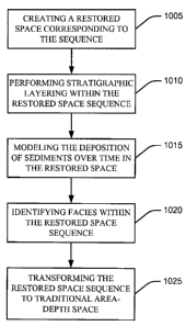
[0023] In practice, as shown in Fig. 10, a restored space stratigraphic
layering system operates on a
sequence in traditional area-depth space by creating a restored space
corresponding to the sequence
(block 1005). The system then performs stratigraphic layering within the
restored space sequence
(block 1010). The system then models the deposition of sediments over time in
the restored space
(block 1015). The system then identifies facies within the restored space
sequence (block 1020).
The system then transforms the restored space sequence to traditional area-
depth space (block
1025).
[0024] In one embodiment, the restored space stratigraphic layering system is
stored in the form of
a computer program on a computer readable media 1105, such as a CD or DVD, as
shown in Fig.
11. In one embodiment a computer 1110 reads the computer program from the
computer readable
media 1105 through an input/output device 1115 and stores it in a memory 1120
where it is
prepared for execution through compiling and linking, if necessary, and then
executed. In one
embodiment, the system accepts inputs through an input/output device 1115,
such as a keyboard,
and provides outputs through an input/output device 1115, such as a monitor or
printer. In one
embodiment, the system creates an earth model in memory 1120 or modifies an
earth model that
already exists in memory 1120.
[0025] In one embodiment, the earth model that resides in memory 1120 is made
available through
a network 1125 to a remote real time operating center 1130. In one embodiment,
the remote real
5
CA 02713390 2010-07-27
WO 2009/096942 PCT/US2008/052190
time operating center makes the earth model, or data from the earth model,
available through a
network 1135 to help in the planning of oil wells 1140 or in the drilling of
oil wells 1140.
[0026] The text above describes one or more specific embodiments of a broader
invention. The
invention also is carried out in a variety of alternate embodiments and thus
is not limited to those
described here. The foregoing description of the preferred embodiment of the
invention has been
presented for the purposes of illustration and description. It is not intended
to be exhaustive or to
limit the invention to the precise form disclosed. Many modifications and
variations are possible in
light of the above teaching. It is intended that the scope of the invention be
limited not by this
detailed description, but rather by the claims appended hereto.
6