Note: Descriptions are shown in the official language in which they were submitted.
CA 02717514 2015-11-02
SYSTEMS AND METHODS FOR CONNECTIVITY ANALYSIS USING
FUNCTIONAL OBJECTS
CROSS-REFERENCE TO RELATED APPLICATION
[0001] This application claims the benefit of U.S. Provisional Patent
Application 61/126,471
filed May 5, 2008 entitled SYSTEMS AND METHODS FOR CONNECTIVITY ANALYSIS USING
FUNCTIONAL OBJECTS.
TECHNICAL FIELD
[0002] The invention relates generally to connectivity analysis and, more
particularly, to using
functional objects in providing connectivity analysis.
BACKGROUND OF THE INVENTION
[0003] In the geosciences, it is not uncommon to generate models of
geologic areas of interest in
order to study or analyze various aspects of the geologic structure. Such
models may represent various
surface and/or subsurface structures. For example, when utilized with respect
to hydrocarbon exploration
and production, models are often generated of subsurface regions for use in
identifying structures
associated with hydrocarbon reservoirs, determining fluid migration
characteristics, estimating
hydrocarbon reserves, etc. Such models may be based upon data provided by data
collection techniques
such as seismic testing, geologic measurement, reservoir monitoring,
simulation, etc.
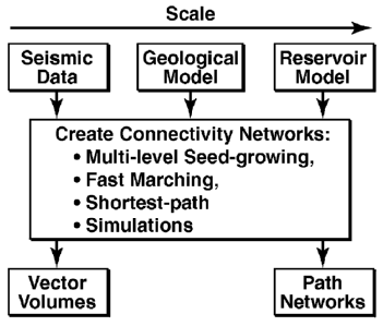
[0004] An underlying geologic data set or data volume, as may be provided
using
one of the foregoing data collection techniques, may be processed to provide
connection
pathway information. For example, a web of connection pathways may be derived
from geologic data sets using various techniques such as volume-based methods
(e.g.,
multi-level seed-growing methods and fast marching methods) and network-based
methods (e.g., shortest-
path methods). Detail with respect to using such techniques to identify
connected
pathways within geologic data volumes is provided in United States patent
number 6,823,266 entitled
"Method for Performing Object-Based Connectivity Analysis in 3-D Seismic Data
Volumes," United
States patent application publication number 2007/0027666 entitled
"Characterizing Connectivity in
Reservoir Models Using Paths of Least Resistance," and World Intellectual
1
CA 02717514 2015-11-02
Property Organization international publication number W02006/127151 entitled
"A Rapid Method for
Reservoir Connectivity Analysis Using a Fast Marching Method,".
[0005] The results of the foregoing techniques often provide a web of
hundreds of connection
pathways for various locations within the data volumes. These connection
pathways are commonly
represented geometrically as polylines in a graphical representation of the
data volume (e.g., a three-
dimensional (3D) Earth model of the geographic area of interest represented by
the data set). For
example, to facilitate connectivity analysis within the geographic area of
interest a 3D Earth model image
is displayed with a static connection pathways map thereon. The connection
pathways may be represented
by a group of geometrical polylines, wherein polyline shows the connection
from one geological locations
to another.
=
[0006] Other practices utilize a connected volume technique in which a
vector is stored in each
cell/voxel indicating a connection pathway to a connected neighboring
cell/voxel. In this kind of
connection pathway representation, an interactive streamline display may be
used to show the connected
relations among given points of interests within the connected volume. Detail
with respect to the
representation of connection pathways using connected volumes is provided in
Crawfis, R and Max,
Nelson "Direct volume visualization of three-dimensional vector fields,"
Proceedings of the 1992
workshop on Volume visualization.
[0007] Useful analysis of the connection pathways within a geologic model
(e.g., 3D Earth
model) involves identification particular connection pathways and an
understanding of the interaction or
interrelationship of such connection pathways with various data objects in the
model. However, the large
number of connection pathways generally makes it to difficult to effectively
interpret the connectivity
results and to focus on the specific paths of most relevance to the analysis
that the geoscientist or engineer
wishes to perform. For example, a user presented with hundreds of connection
pathways may be required
not only to visually identify connection pathways of interest within ,a
confusing web of connection
pathways, but also to conclude which connection pathway or pathways are
relevant to a particular line of
analysis. Even upon visually identifying a particular connection pathway
within a mass of connection
pathways, the relevance of that particular connection pathway to a line of
analysis may not be
immediately apparent in the foregoing visual representations, such as due to
2
CA 02717514 2010-09-02
WO 2009/137176 PCT/US2009/038111
interaction between the connection pathways and data objects, interaction
between the
connection pathways themselves, etc.
BRIEF SUMMARY OF THE INVENTION
[0008] The present invention is directed to systems and methods which
utilize functional
objects in connectivity analysis. Functional objects used in providing
connectivity analysis
according to embodiments of the invention have dynamic regions associated
therewith, such
as to define an area of uncertainty, for facilitating exploring connectivity.
Functional objects
may be denoted by a geological feature, a user-defined location, a critical
point in a
connection network, a region within a 3D volume, etc. Each functional object
preferably
possesses and/or has associated therewith an ability to obtain information
such as relevant
connection pathways, linked regions of interest, statistical connection
information, etc.
[0009] Such functional objects may be utilized with respect to a modeled
space
visualization environment, such as a 3D Earth model visualization environment,
to allow for
interactive analysis of connectivity within the modeled space. For example,
connectivity may
be estimated by the concurrent connections of spatial regions within a modeled
space.
Desired connectivity information or identification of connection pathways of
interest
(referred to herein as a network of interest) can thus be revealed
interactively from within a
confusing web of connection pathways through use of the functional objects.
For example,
through interactive repositioning of a functional object (or set of functional
objects)
connections that pass through or nearby a specific location (e.g., a well path
target or set of
targets) may be identified. Additionally or alternatively, logical operations
may be applied
with respect to one or more functional objects to extend or reduce the
connectivity of interest
(e.g., pathways passing through a first functional object AND a second
functional object).
[0010] Embodiments of the invention are particularly useful with respect
to geological
analysis, such as in association with hydrocarbon exploration and production.
Understanding
connectivity within a framework of a 3D Earth model is often desired for the
management of
an exploration and production asset (e.g., field, reservoir, well, etc.) from
exploration to
abandonment. Accordingly, connectivity within a 3D Earth model may be explored
utilizing
functional objects with dynamic regions within a 3D visualization environment
according to
embodiments of the invention. When utilized with respect to hydrocarbon
exploration and
production, functional objects of the present invention and connectivity
analysis associated
therewith may be used in analyzing hydrocarbon reservoirs, determining fluid
migration
3
CA 02717514 2010-09-02
WO 2009/137176 PCT/US2009/038111
characteristics, estimating hydrocarbon reserves, well path planning, platform
location,
reservoir management, etc.
[0011] According to embodiments of the invention, a model of a geologic
area of interest
is provided, wherein the model includes representations of geologic features
and a plurality of
connection pathways. One or more functional objects are preferably defined
within this
model for connection analysis according to embodiments of the invention. Such
functional
objects may be user defined (e.g., based upon a user selected location, user
selected structural
object, user selected connection pathway network topological feature, user
selected region in
the data volume, user issued logical query, etc.) or automatically identified
(e.g., identified by
relationship to a structural object, identified by connection pathway network
topological
feature, identified by a functional attribute relevant to the analysis to be
performed, identified
by a particular region in the data volume, identified by a particular
characteristic, etc.), and
preferably are associated with at least one functional attribute (e.g.,
connectivity associated
with a particular structural object, associated with a particular connection
pathway network
feature, having a connectivity attribute meeting particular criteria, etc.) of
the geologic area of
interest. Using one or more such functional objects, a subset of connection
pathways within
the model may be identified, wherein connection pathways of this subset share
some
connectivity attribute associated with the functional object(s). For example,
a subset of
connection pathways may comprise relevant connection pathways for a given set
of
interpreted horizons, faults, wells and other geologic and engineering data
objects. Thus
connectivity within the geologic area of interest may be analyzed with respect
to one or more
functional attributes using the subset of connection pathways.
[0012] Functional objects of embodiments of the invention may be
dynamically and
interactively manipulated to refine or revise the analysis. For example,
functional objects
may be added, deleted, and/or repositioned within the model volume in order to
change the
subset of connection pathways identified, to revise a functional attribute of
the analysis, to
explore interaction of connection pathways and/or structural objects, etc.
Similarly, dynamic
regions associated with functional objects may be resized, reshaped, added,
and/or deleted to
change the subset of connection pathways identified.
[0013] Modeling data as may be used in deriving a model space or volume in
which
functional objects of embodiments of the invention are used may be provided by
data
collection techniques such as seismic testing, geologic measurement, reservoir
monitoring,
4
CA 02717514 2010-09-02
WO 2009/137176 PCT/US2009/038111
simulation, etc. Moreover, using the aforementioned dynamic regions of
embodiments of the
functional objects, embodiments of the present invention may be utilized with
respect to
model volumes derived from a plurality of modeling data. For example, a first
and second
model of a geologic area of interest may be provided, wherein the first model
is derived from
a data set provided by a first data collection technique (e.g., seismic data),
and wherein the
second model is derived from a data set provided by a second data collection
technique (e.g.,
geologic measurement data). The first and second model may be different in
many regards,
such as being provided in a different scale, providing different levels of
detail, etc. However,
both the first and second model preferably include representations of geologic
features within
the geologic area of interest and have a plurality of connection pathways
defined therein. The
first and second models may be correlated using various points (e.g.,
structural features,
connection pathway network topological features, etc.) within the first and
second models to
provide a correlated model of the geological area of interest. One or more
functional objects
are preferably defined within this correlated model, as discussed above, for
connection
analysis according to embodiments of the invention. Using one or more such
functional
objects, a subset of connection pathways within the correlated model may be
identified.
Connection pathways of this subset, although preferably sharing some
connectivity attribute
associated with the functional object(s), may be associated with the first or
second model.
Connectivity within the geologic area of interest may be analyzed with respect
to one or more
functional attributes using the subset of connection pathways.
[0014] Connection pathways utilized in connectivity analysis according
to embodiments
of the present invention may be in a number of forms. For example, embodiments
of the
invention facilitate interactive analysis of connectivity from streamline-
based volumes, as
well as geometry-based network results. Moreover, embodiments of the invention
facilitate
connectivity investigation using multiple connection topologies from various
sources and
algorithms.
[0015] From the above, it can be appreciated that embodiments of the
invention provide
for effective evaluation of multiple connectivity scenarios in multiple levels
from various
modeling sources. Embodiments facilitate dynamic analysis of critical points
and critical
paths for geological objects, and rapid visualization of connections through
logical
operations. The construct of functional objects and application of logical
operations to
identify networks of interest within a web of connection pathways as discussed
above can
provide considerable insight into complicated networks and geological
structures. Users may
5
CA 02717514 2015-11-02
build a network of interest starting with one functional object and adding
others. Additionally, users can
begin with a large network of interest, and see what happens as particular
functional objects are removed.
Through operation of embodiments of the invention, users can understand how
geological objects are
related or tied together by locating the parts of a network of interest that
are completely disconnected
from one another or, similarly, locating parts of the connectivity that would
become disconnected
components if various features (e.g., functional objects, connection pathways,
etc.) were removed.
Moreover, users can understand how geological objects are related by locating
parts of a network of
interest that form a sub-network such that each object of a sub-network is
connected to members of
certain group.
[0016] Various additional processing may be utilized with respect to
networks of interest to
provide further insight into complicated connectivity networks and geological
structures. For example, a
hierarchical path classification (e,g., based on distance measurements) may be
applied to a network of
interest to produce a tree structure in which objects that are most similar to
other objects are identified
and/or classified. Groups of geological objects that are closely connected
within groups, and less
connected between groups, may thus be identified and/or classified.
[0017] The foregoing has outlined rather broadly the features and
technical advantages of the
present invention in order that the detailed description of the invention that
follows may be better
understood. Additional features and advantages of the invention will be
described hereinafter which form
the subject of the claims of the invention. It should be appreciated by those
skilled in the art that the
conception and specific embodiment disclosed may be readily utilized as a
basis for modifying or
designing other structures for carrying out the same purposes of the present
invention. The novel features
which are believed to be characteristic of the invention, both as to its
organization and method of
operation, together with further objects and advantages will be better
understood from the following
description when considered in connection with the accompanying figures. It is
to be expressly
understood, however, that each of the figures is provided for the purpose of
illustration and description
only and is not intended as a definition of the limits of the present
invention.
6
CA 02717514 2010-09-02
WO 2009/137176 PCT/US2009/038111
BRIEF DESCRIPTION OF THE DRAWING
[0018] For a more complete understanding of the present invention,
reference is now
made to the following descriptions taken in conjunction with the accompanying
drawing, in
which:
[0019] FIGURE 1 shows a flow diagram of operation to use functional objects
in
providing connectivity analysis according to an embodiment of the invention;
[0020] FIGURE 2 shows identification of connection pathways according to
an
embodiment of the invention;
[0021] FIGURE 3 shows a computer system adapted for use according to an
embodiment
of the present invention;
[0022] FIGURE 4A shows a spatial representation of a network of interest
according to
an embodiment of the invention;
[0023] FIGURE 4B shows a topological representation of a network of
interest according
to an embodiment of the invention;
[0024] FIGURE 5 shows a flow diagram of operation of an example
implementation for
planning an injection well for a given production well according to an
embodiment of the
invention; and
[0025] FIGURE 6 shows a flow diagram of operation of an example
implementation for
connectivity analysis from multiple models according to an embodiment of the
invention.
DETAILED DESCRIPTION OF THE INVENTION
[0026] Directing attention to FIGURE 1, a high level flow diagram of
operation to use
functional objects in providing connectivity analysis according to an
embodiment of the
invention is shown. At block 101 of FIGURE 1 a model of an area of interest is
obtained.
The model may comprise a 3D Earth model of a particular subsurface area or
region. For
example, a 3D Earth model of an area encompassing one or more potential
reservoirs may
provide a model of an area of interest according to embodiments of the
invention used with
respect to geologic analysis. Such models may be generated using data provided
by data
collection techniques such as seismic testing, geologic measurement, reservoir
monitoring,
7
CA 02717514 2010-09-02
WO 2009/137176 PCT/US2009/038111
simulation, etc. Models utilized according to embodiments of the invention are
preferably
adapted for display within a modeled space visualization environment, such as
a 3D Earth
model visualization environment. Models as may be utilized according to
embodiments of
the invention may be provided by modeling programs such as PETREL, available
from
Schlumberger Information Solutions, and/or Earth modeling programs such as
GOCAD,
available from Paradigm Geotechnology By.
[0027] Models utilized according to embodiments of the invention
preferably include
representations of various features therein. For example, a model of a
geologic area of
interest may include representations of features such as potential hydrocarbon
reservoirs,
geologic objects (e.g., layers or strata, faults, regions having particular
attributes such as a
common media or permeability, crevasses, etc.) and engineering objects (e.g.,
wells,
fractures, etc.). Such features are collectively referred to herein as
structural objects.
[0028] At block 102 connection pathways are identified in the model.
According to
embodiments of the invention, the model obtained at block 101 may be obtained
having
connection pathways previously identified therein, and thus block 102 may be
omitted or may
be used to provide identification of additional connection pathways.
Additionally or
alternatively, connection pathways may be identified in the model at a later
point in
processing, such as with or after identification of functional objects of the
present invention.
[0029] A web of connection pathways may be derived from geologic data
sets using
various techniques such as volume-based methods (e.g., multi-level seed-
growing methods
and fast marching methods) and network-based methods (e.g., shortest-path
methods). As
shown in FIGURE 2, the connection pathways may represent connected volumes
(e.g., vector
volumes) or path networks (e.g., connection polylines). The foregoing
connection pathways
are preferably adapted for display within the modeled space visualization
environment (e.g.,
3D Earth model visualization environment) that the underlying model may be
displayed
within. For example, to facilitate connectivity analysis within the geographic
area of interest
a 3D Earth model image is displayed with a static connection pathways map
thereon.
[0030] At block 103 functional objects are identified with respect to
the model. Any
number of functional objects may be identified according to embodiments of the
invention,
including identifying a single functional object or identifying a plurality of
functional objects.
Multiple such functional objects may be selected for use simultaneously (e.g.,
in a same
analysis) or separately (e.g., in different analyses). As will be better
appreciated from the
8
CA 02717514 2010-09-02
WO 2009/137176 PCT/US2009/038111
discussion which follows, functional objects of embodiments of the present
invention are
dynamically and interactively utilized and, thus, the particular functional
objects identified
may change (e.g., additional functional objects identified and/or previously
identified
functional objects no longer being identified as functional objects).
Moreover, functional
objects of embodiments of the invention may themselves be manipulated to
refine or revise
the analysis. For example, dynamic regions associated with functional objects
may be
resized, reshaped, added, and/or deleted.
[0031] Functional objects utilized according to embodiments of the
invention are
preferably associated with at least one functional attribute of interest. For
example, one or
more functional objects may provide or otherwise be associated with
connectivity with a
particular structural object. Similarly, one or more functional objects may be
associated with
a particular connection pathway or other connection pathway network feature.
Functional
objects may, by way of example, have a connectivity attribute meeting
particular criteria
(e.g., meeting a transmission or flow timing threshold in providing
connectivity between two
structural objects, meeting a flow rate threshold in providing connectivity
between two
structural objects, etc.).
[0032] From the foregoing, it can be appreciated that functional objects
of embodiments
are associated with functional aspects of the structure of modeled environment
or
connectivity network of the modeled environment. In the example of geologic
analysis,
functional objects may be geological based, network based, etc. For example,
in the context
of hydrocarbon exploration and/or production based geologic analysis, geologic
based
functional objects may be associated with functional attributes of wells
(e.g., perforation
intervals, targets, zones, etc.), reservoirs (e.g., horizon surfaces, fault
surfaces, flow units,
bright spots, property regions, etc.), and/or the like. Further in the context
of hydrocarbon
exploration and/or production based geologic analysis, network based
functional objects may
be associated with functional attributes of network topology (e.g., minimum
cut, maximum
flows, etc.), clusters (e.g., similarity in lexical topology, similarity in
semantic topology, etc.),
and/or the like.
[0033] A region or penumbra may be associated with a functional object
of the present
invention. Such a region may define an area of uncertainty around or in
association with a
functional object. For example, a region may be spatially defined about a
functional object
(e.g., margin area), associated with an area of uncertainty with respect to
the spatial limits of
9
CA 02717514 2010-09-02
WO 2009/137176 PCT/US2009/038111
the functional object, for facilitating exploring connectivity affected by the
functional object.
Such regions may be defined by attributes other than space or location, such
as being defined
by variance of a selected attribute (e.g., flow rate). Functional object
regions utilized
according to embodiments of the invention may preferably be formed in any
desirable size or
shape and are dynamically adjustable. For example, a region associated with a
functional
object may be resized, reshaped, added, and/or deleted as desired, thereby
providing a
functional object dynamic region.
[0034] Functional objects utilized according to embodiments of the
invention may be
user defined. For example, a user may interact with a visualization
environment to select one
or more locations within the modeled volume as functional objects.
Additionally or
alternatively, the user may interact with the visualization environment to
select one or more
structural objects, connection pathways, network features, etc. as functional
objects. As but
one example, a user may identify a particular structural object, such as a
boundary between
sedimentary layers in an Earth model, through which a number of connection
pathways pass
through and/or pass near. This structural object may be selected by the user
as a functional
object for use in analyzing the connectivity within the model. An area of
uncertainty or
dynamic region may be defined in association with the functional object, such
as through the
user graphically selecting a desired region around the structural object.
Additionally or
alternatively, the user may define the region mathematically (e.g., defined as
within X
distance of the structural object's surface), functionally (e.g., defined as
the area meeting
some functional attribute, such as permeability, interfacing with the
structural object), etc.
[0035] A user may define functional objects in a number of ways. For
example, in a
visualization environment, a user may manipulate a pointing device (e.g.,
mouse, stylus of a
digitizing tablet, or touch screen) to select a structural object or identify
a location for
designation as a functional object. Such graphical selection may be
supplemented through
the use of data input, such as to provide numeric data to define an area of
uncertainty
associated with the functional object. Of course, graphical input of such
supplemental data
may be accommodated, such as to allow a user to draw or "lasso" an area of
uncertainty.
[0036] Rather than graphically defining a functional object, a user may
input data (e.g.,
textual and/or numerical data) to define a desired functional object. The use
of data input to
define a desired functional object may be particularly useful with respect to
functional objects
which are not readily identifiable from a graphical display. For example, a
functional object
CA 02717514 2010-09-02
WO 2009/137176 PCT/US2009/038111
defined by a particular functional characteristic (e.g., media permeability or
flow rate) may
more easily be selected through data input than graphical selection.
Accordingly,
embodiments of the present invention facilitate defining of functional objects
through a
plurality of techniques, including combinations of techniques (e.g., graphical
input and data
input).
[0037]
Functional objects, and/or areas of uncertainty or dynamic regions, may
additionally or alternatively be automatically defined according to
embodiments of the
invention. For example, computer based algorithms may operate to identify one
or more
functional object by identifying structural objects meeting selected criteria,
a particular
relationship to a structural object, connection pathway network features
meeting selected
criteria, critical points in a connection pathway network, functional
attributes relevant to the
analysis to be performed, particular regions in the data volume, particular
characteristics, etc.
[0038]
Irrespective of how a functional object is defined, functional objects of the
present
invention may preferably be selected/deselected,
activated/deactivated,
configured/reconfigured, and/or the like. Accordingly, functional objects of
embodiments of
the invention may be dynamically and interactively manipulated to refine or
revise analysis
associated therewith.
[0039]
Data in addition to that useful in identifying functional objects may be
provided at
block 103. For example, data regarding logical operations or logical
relationships between
various objects (e.g., the identified functional objects and/or structural
objects) may be
provided by a user. As will be better understood from the discussion which
follows, a user
may define logical operations useful in analysis of the modeled area of
interest. For example,
data regarding logical operations or logical relationships provided at block
103 may comprise
logical operators (e.g., "AND", "OR", and "NOT") to be utilized with respect
to functional
objects and/or structural objects and other data appropriate for defining
logical operations. A
logical operation defined by such logical operators and other information may
thus provide
Boolean logic operations with respect to various objects, functions, and
attributes.
[0040]
The foregoing areas of uncertainty or dynamic regions defined in association
with
a functional object are utilized in performing logical operations according to
embodiments of
the invention. For example, where a logical operation is determining the
connection
pathways which interact with a particular functional object, the functional
object and its
associated area of uncertainty may be used for the determination, such as by
identifying all
11
CA 02717514 2010-09-02
WO 2009/137176 PCT/US2009/038111
connection pathways which interact (e.g., touch) with the functional object
and its area of
uncertainty. The logical operations may be performed differently as between
the functional
object and area of uncertainty, if desired, such as to utilize a weighting
factor based upon an
uncertainty metric, to utilize a gradient defined with respect to the area of
uncertainty, etc.
[0041] According to embodiments of the invention, logical expressions such
as the
foregoing may be utilized to identify functional objects. That is, functional
objects of the
present invention may be composed in logical expressions, such as to further
limit or extend
the connectivity among regions of interest.
[0042] At block 104 information (e.g., functional attributes) associated
with the
functional objects is obtained. For example, functional properties (e.g.,
connectivity
properties) associated with functional objects may be determined from the
model and
associated with the corresponding identified functional object. Similarly,
connection
pathways associated with functional objects (e.g., connection pathways passing
through
and/or in communication with a functional object, and its area of uncertainty)
may be
determined from the model and associated with the corresponding identified
functional
object. It should be appreciated that information associated with the
functional objects may
comprise results of various calculations and data processing. For example,
embodiments of
the present invention operate to associate statistical information, such as
summarized
statistics on timings, shortest paths, and fastest flows to other regions of
interest, with the
functional objects.
[0043] Functional objects of the present invention may further be
annotated at block 104
of embodiments. For example, functional objects of embodiments of the present
invention
may be annotated with the foregoing associated information or other attributes
or properties
of the functional objects. According to one embodiment of the invention,
functional objects
are annotated with object properties (e.g., as 3D iconic graphics, or
chartings) in the
visualization environment.
[0044] Where connection pathways are identified in the model at a later
point in
processing than illustrated at block 102 discussed above, such identification
of connection
pathways may be performed at block 104, if desired. Such an embodiment
facilitates the
generation of only those connection pathways which are associated with
identified functional
objects and the logical operations performed therewith, thereby reducing the
processing
power and time utilized in identifying connection pathways.
12
CA 02717514 2010-09-02
WO 2009/137176 PCT/US2009/038111
[0045] At block 105, one or more network of interest is generated from
the web of
connection pathways, the functional objects, and logical operation data (if
provided). For
example, the connection pathways associated with each functional object may be
identified
within the model space to thereby provide one or more subsets of connection
pathways..
Where logical operation data is provided, the appropriate logical operations
are preferably
applied with respect to the functional objects, structural objects, connection
pathways, and/or
other attributes to provide one or more subsets of connection pathways in
accordance with
such logical operations.
[0046] Generation of networks of interest according to embodiments of
the invention
may comprise more than identification of subsets of connection pathways. For
example,
embodiments of the present invention may perform processing with respect to
such
connection pathways subsets to derive network topology feature information
therefrom, such
as to identify critical connections or junctions, to identify interaction
between connection
pathways, etc.
[0047] According to embodiments of the invention, the foregoing subsets of
connection
pathways, and preferably network topology feature information, are presented
to the user
graphically in a visualization environment. For example, connection pathways
associated
with particular subsets may be displayed in the modeled volume as presented in
a
visualization environment in colors, intensities, line widths, etc. unique to
each such subset.
Various features within the model, such as connection pathways, structural
objects, etc., not
associated with the subsets of connection pathways may be hidden from view,
reduced in
intensity, "grayed out," etc. (collectively referred to as deemphasized) to
simplify the
visualization environment presentation. Moreover, various ones of the
connection pathway
subsets, or portions thereof, may be deemphasized, such as when one or more
functional
objects associated therewith is deactivated, to further simplify the
visualization environment
presentation.
[0048] Various representations of connection pathways may be presented
graphically
according to embodiments of the invention. For example, spatial
representations wherein
spatial relationships between various objects are represented, topological
representations
wherein connectivity relationships between various objects are represented,
etc. Additionally
or alternatively, database and spreadsheet type representations indicating the
relationship
among objects may be used according to embodiments of the invention. Directing
attention
13
CA 02717514 2010-09-02
WO 2009/137176 PCT/US2009/038111
to FIGURES 4A and 4B, simplified examples of graphical presentation of
connection
pathways in a visualization environment are shown. Specifically, FIGURE 4A
shows a
spatial representation of a network of interest with functional objects
according to an
embodiment of the invention and FIGURE 4B shows a topological representation
of a
network of interest with functional objects according to an embodiment of the
invention.
Embodiments of the invention may utilize a particular form of graphical
representation, such
as may be selected based upon the particular analysis being conducted, the
particular
information available, user selection, etc. Moreover, embodiments of the
present invention
facilitate provide graphical representations in multiple forms, such as to
allow a user to
dynamically toggle between various forms of graphical representation.
[0049] Referring to FIGURE 4A, functional objects F1, F2, and F3 have
been defined as
described above, wherein functional object F1 comprises an engineering object
(e.g., an
injection well), functional object F2 comprises a geological object (e.g., a
fault), and
functional object F3 comprises an engineering object (e.g., a production
well). Assuming that
"T" is a task of finding all connection pathways contacting a given functional
object and the
subject connection pathways are represented by connection pathways ph p2, p3,
and p4, then
F1(T) = {ill, p2, P35 p4}, FAT) = {ill}, and F3 = {p15 p2}. The results of
task "T" are
graphically represented in the spatial representation of FIGURE 4A, it being
appreciated that
additional, deemphasized connection pathways (e.g., p5, . . . pn) may be
present in the
modeled environment. Accordingly, a user may readily view, analyze, and/or
interact with
such a representation of the network of interest as described herein.
[0050] Referring now to FIGURE 4B, functional objects F1, F2, and F3 and
connection
pathways pi, P25 P35 and p4 discussed above are shown in a topological
representation.
Assuming functional objects F1 and F3 are wells (e.g., injection well and
production well) and
functional object F2 is a sealed fault, a user can readily appreciate that the
only connection
pathway from functional object F1 to functional object F3 is connection
pathway p2.
[0051] At block 106 the model is analyzed using the generated network(s)
of interest.
For example, a user may view the model in a visualization environment, having
one or more
subsets of connection pathways associated identified using functional objects
of the present
invention thereon, to readily appreciate particular connectivity attributes of
the area of
interest modeled. The user may further interact with the functional objects to
access
information and/or annotations associated therewith. Such interaction may
comprise the user
14
CA 02717514 2010-09-02
WO 2009/137176 PCT/US2009/038111
activating and/or deactivating various functional objects to deemphasize
particular
connection pathways, to view different information, to analyze different
regions of interest, to
analyze different connectivity properties, etc. Further, the properties of the
functional objects
and/or their interaction with the connection pathways may be explored to
identify most
critical connections interactively.
[0052] At block 107 a determination is made as to whether the analysis
provided the
desired outcome. For example, the user may determine whether the desired
information is
provided with respect to the functional objects and subsets of connection
pathways associated
therewith. If the desired outcome has been achieved, processing according to
the illustrated
flow diagram ends. However, if the desired outcome has not been achieved,
processing
proceeds to block 108.
[0053] At block 108 of the illustrated embodiment the network of
interest generation
criteria is revised. For example, functional objects may be added, deleted,
resized, reshaped,
and/or repositioned within the model volume in order to change the subset of
connection
pathways identified, to revise a functional attribute of the analysis, to
explore interaction of
connection pathways and/or structural objects, etc. Similarly, areas of
uncertainty or
dynamic regions associated with functional objects may be resized, reshaped,
added, and/or
deleted to change the resulting analysis. Likewise, data regarding logical
operations or
logical relationships between various objects may be added, deleted, or
otherwise revised to
change the resulting analysis. For example, a functional object of the present
invention can
be repositioned (such as moving to a critical point in a network) and/or
reshaped (such as
modifying a well path trajectory) to investigate other possible connections.
[0054] At block 109 a determination is made as to whether new functional
objects or
logical operations are being added. If so, processing proceeds to block 103 to
facilitate
identification of the new functional objects and/or logical operations.
However, if no new
functional objects and/or logical operations are being added, processing
according to the
illustrated embodiment proceeds to block 104 wherein information associated
with the
functional objects is obtained and annotations for the functional objects made
as described
above.
[0055] From the above, it can be appreciated that embodiments of the
present invention
provide an interactive and iterative process for connectivity analysis.
Accordingly, during
analysis sessions (such as well path planning, production operation, or
migration study),
CA 02717514 2010-09-02
WO 2009/137176 PCT/US2009/038111
functional objects may be added, deleted, activated, or deactivated and the
appropriate
connections among the regions of interest modeled and displayed. Functional
objects can
also be repositioned or reshaped during analysis sessions in order to
investigate other possible
connections.
[0056] FIGURE 3 illustrates computer system 300 adapted for use according
to an
embodiment of the present invention. Computer system 300 of the illustrated
embodiment
includes central processing unit (CPU) 301 coupled to system bus 302. CPU 301
may be any
general purpose CPU, such as a processor from the PENTIUM family of processors
available
from Intel Corporation or a processor from the POWERPC family of processors
available
from the AIM alliance (Apple Inc., International Business Machines
Corporation, and
Motorola Inc.). However, the present invention is not restricted by the
architecture of CPU
301 as long as CPU 301 supports the inventive operations as described herein.
Although a
single processor configuration is represented in FIGURE 3, computer systems
utilized
according to embodiments of the invention may comprise networked multi-
processor
systems.
[0057] Bus 302 of the illustrated embodiment is coupled to random access
memory
(RAM) 303, such as may comprise SRAM, DRAM, SDRAM, flash memory, and/or the
like.
Read only memory (ROM) 304, such as may comprise PROM, EPROM, EEPROM, and/or
the like, is also coupled to bus 302 of the illustrated embodiment. RAM 303
and ROM 304
hold user and system data and programs as is well known in the art. Bus 302 is
also coupled
to input/output (I/O) controller 305, communications adapter 311, user
interface adapter 308,
and display adapter 309.
[0058] I/O controller 305 connects to storage device 306, such as may
comprise one or
more of a hard disk, an optical disk (e.g., compact disk (CD) or digital
versatile disk (DVD)),
a floppy disk, and a tape, to the computer system. I/O controller 305 of the
illustrated
embodiment is also connected to printer 314, which allows the system to print
information
such as documents, photographs, etc. Such a printer may be a traditional
printer (e.g. dot
matrix, laser, etc.), a fax machine, a copy machine, and/or the like.
[0059] Communications adapter 311 is adapted to couple computer system
300 to
network 312 to provide communications to and/or from external systems,
devices, networks,
etc. Network 312 may comprise the public switched telephone network (PSTN), a
local area
network (LAN), a metropolitan area network (MAN), a wide area network (WAN),
an
16
CA 02717514 2010-09-02
WO 2009/137176 PCT/US2009/038111
extranet, an intranet, the Internet, a cellular network, a cable transmission
network, and/or the
like.
[0060] User interface adapter 308 of the illustrated embodiment couples
various user
input devices to the computer system. For example, keyboard 313, pointing
device 307, and
microphone 316 may be coupled through user interface adapter to accept various
forms of
user input. Similarly, speakers 315 may be coupled through user interface
adapter to provide
user interface output.
[0061] The display adapter 309 provides an interface to display 310.
Accordingly, CPU
301 may control display of various information, including text, graphics, and
images upon
display 310 through display adapter 309. Display 310 may comprise a cathode
ray tube
(CRT) display, a plasma display, a liquid crystal display (LCD), a projector,
and/or the like.
Although not expressly shown in the illustrated embodiment, display 310 may
provide for
input of data as well as output of data. For example, display 310 may comprise
a touch
screen display according to embodiments of the invention.
[0062] When implemented in software, elements of embodiments of the present
invention
are essentially code segments operable upon a computer system, such as
computer system
300, to perform the necessary tasks. The program or code segments can be
stored in a
computer readable medium, such as RAM 303, ROM 304, and/or storage device 306.
Additionally or alternatively, the code segments may be downloaded via
computer networks,
such as network 312.
[0063] As previously mentioned, embodiments of the invention preferably
utilize a 3D
representation of the 3D Earth model on a computer, such as computer system
300, with
visualization capabilities. A commercial software product providing 3D
representation of 3D
Earth models as may be adapted for use with functional objects according to
the present
invention is the GOCAD geologic and seismic interpretation program available
from
Paradigm Geotechnology By. Data input to such software adapted in accordance
with
embodiments of the invention may include geologic raw and interpreted data
(e.g., well
path/curves, horizon surfaces, faults, seismic data, etc.), engineering raw
and interpreted data
(e.g., well completion intervals, well perforation zones, etc.), a geologic
model with
associated properties (e.g., horizons, porosity, horizontal permeability,
vertical permeability,
net to gross, facies, fluid saturations, etc.), and a simulation model and
associated properties
17
CA 02717514 2010-09-02
WO 2009/137176 PCT/US2009/038111
(e.g., horizons, porosity, horizontal permeability, vertical permeability,
fluid saturations, fluid
rates, fluid ratios, fluid cumulative, reservoir pressure, well pressures,
etc.).
[0064] Software adapted according to embodiments of the invention
facilitates the
identification or defining of functional objects as described herein, such as
based on existing
geological objects, dynamic regions of interests on modeling grid/volume data
sets, critical
nodes of the connectivity networks, etc. Using such functional objects in
combination with
computational implementation of algorithms, software adapted according to
embodiments of
the invention interact with data input thereto (e.g., the aforementioned
geologic data,
engineering data, geologic model, and simulation model) to model and
investigate the
connectivity. Such modeling and investigating connectivity may comprise volume-
based
methods (e.g., multi-level seed-growing, fast marching for modeling
connectivity; etc.),
network-based methods (e.g., shortest-path for modeling connectivity; etc.),
network analysis
to understand network topology and flow mechanisms, network search algorithms
based on
statistical properties of connected path, link topology of the objects and/or
semantic topology
of the objects, spatial logic operations of possible pathways for reducing or
extending the
connections among objects, and/or the like.
[0065] An example of a spatial logic operation for a connectivity
network as may be
utilized in modeling and investigating connectivity according to embodiments
of the present
invention follows. A connectivity network, G = (V, E), includes a set of
vertices objects, V =
{ vi, v2, ...}, and a set of edge objects, E = {el, e2,...}, such that each
edge ek is identified
with a pair (vi, vj) of vertices. The vertices vi and vj are called the end-
vertices of edge ek.
Two edges are called equal if an only if they have the same end-vertices and
their paths has
the same spatial location in 3D space. A network of interest, Gk, is called
the k-th sub-
network of a network, G, if all vertices and all the edges of Gk are in G, and
each edge of Gk
has the same end vertices. Assume that Fi, F2, ... Fi, are functional objects
and that Ti, T25 = = =
Tm are tasks defined for the functional objects. Each task Ti invokes an
operation to create a
sub-network Gi from G, such that Gu = F(T) is denoted as a sub-network created
by
functional object Fi using task T.
[0066] In the foregoing example of a spatial logic operation, some logic
operations (e.g.,
AND, OR, NOT) as may be implemented by the tasks are shown below. Gi AND G
denotes
a sub-network, Gs, of a network, G, such that each edge, e, in Gs is also in
Gi and G. The
vertices of Gs are the end-vertices of all edges in G. Gi OR G denotes a sub-
network, Gs, of
18
CA 02717514 2010-09-02
WO 2009/137176 PCT/US2009/038111
a network, G, such that each edge, e, in Gs is also in Gi or G. The vertices
of Gs are the end-
vertices of all edges in G. NOT Gi denotes a sub-network, Gs, of a network, G,
such that
each edge, e, in Gs is in G but not in G. The vertices of Gs are the end-
vertices of all edges in
G.
[0067] Having generally described the concepts of the present invention and
embodiments thereof, several example implementations are provided below to aid
in
understanding the concepts discussed herein. Specifically, exemplary operation
to evaluate
connection pathways from one well to another well and exemplary operation to
evaluate
connectivity analysis from multiple models according to embodiments of the
present
invention are shown.
[0068] FIGURE 5 shows a flow diagram of an exemplary implementation to
evaluate
connection pathways from one well to another well. Geoscientists/engineers
often desire to
optimize injection efficiency of injection and production pair of wells and
understand the
pathways along the way. Accordingly, the implementation of FIGURE 5 may be
utilized in
the case of planning an injection well.
[0069] At block 501, a three-dimensional representation of the
subsurface (e.g., 3D Earth
model) and connectivity volume and/or network data (connection pathways) for a
given
geological area of interest are obtained. The data in the model may comprise
geological
objects, such as horizons, faults, and hydrocarbon reservoir model data
volume, as well as
engineering objects, such as existing production wells and fractures.
Attributes of the volume
represents the permeability, porosity or the transmissibility of the
reservoir.
[0070] At block 502, an initial planned injection well is created in the
model. Functional
objects of the present invention are created or identified at blocks 503 and
504. For example,
at block 503 of the illustrated embodiment, functional objects Wi and W2
corresponding to an
injection well and production well, respectively, defined in the model are
created. At block
504 of the illustrated embodiment, functional object F1 corresponding to a
targeted reservoir
flow unit is created.
[0071] At block 505, the connection pathways associated with (e.g.,
interfacing with) the
functional objects are identified. For example, based on the given data set
and geological
objects, a connectivity volume and networks are identified. The connection
pathways
between any two selected objects can be readily available from the networks of
interest. It
19
CA 02717514 2010-09-02
WO 2009/137176 PCT/US2009/038111
should be appreciated that, although various numbers of functional objects may
be created,
functional objects may be selected and deselected to thereby interactively
alter the connection
pathways identified or presented (e.g., not deemphasized) at any particular
time.
[0072] At block 506 tasks, such as may implement various logical
operations, are applied
with respect to the functional objects to identify various sub-networks of
interest. For
example, logical operations may be applied with respect to the pathways
identified above.
Implement of tasks, and/or the application of logical operations, may be
interactive such that
a user can try various task definitions and/or logical operations to see the
associated results,
as are preferably displayed in a visualization environment. The user may
evaluate the various
sub-networks displayed, preferably with various annotations associated
therewith, to
determine if the initial injection well trajectory provides the desired
results.
[0073] At block 507 of the illustrated embodiment, a determination is
made as to whether
the desired injection well results are indicated by the model. If yes,
processing according to
the illustrated embodiment ends. If no, processing proceeds to block 508 where
the user
interacts with the model environment to alter the modeled results. For
example, in the
illustrated embodiment, the user may identify a high permeability area, P1, in
the reservoir as
a functional object, thereby identifying all connection pathways associated
therewith. The
user may use this information to modify the trajectory of the injection well,
and thus the
functional object associated therewith. Processing may proceed again to block
505 where
connection pathways associated with the functional objects are identified as
discussed above.
[0074] It should be appreciated that analyzing all connection pathways,
with their
associated properties, within the modeled volume is likely to be challenging
and impractical.
However, the goal in the foregoing example is to investigate the communication
between the
planned injected well (Well 1) and the production well (Well 2), and evaluate
the effect of the
flow paths on a particular flow units (Flow 1) in the modeled reservoir. Thus
functional
objects W1, W2, and F1 are created for the given objects respectively and a
plurality of
functions are used to identify sub-networks of interest. In particular, a path
function obtains
all the connection pathways which intersect any given object and a property
function obtains
the statistical summary of the properties, such as porosity and timing, of the
paths for any
given object. During well planning sessions in the foregoing exemplary
implementation, a
well trajectory for the injection well (Well 1) is obtained by interactively
moving the target
locations or changing the methods and criterions of the path algorithms. Using
the foregoing
CA 02717514 2010-09-02
WO 2009/137176 PCT/US2009/038111
functions, a subset of connection pathways, and summary of the path properties
related to the
production well (Well 2) are displayed in the visualization environment. Using
path logic,
the user can examine the effect of the current well trajectory to the result
of the connectivity
to the producing well. For example, the user can quickly identify the leak
paths, and
immediately move the current trajectory to a better location. One or more
optimization
process can also be utilized according to embodiments of the invention, such
as to
automatically seek the best well trajectory.
[0075] FIGURE 6 shows a flow diagram of an exemplary implementation to
evaluate
connectivity analysis from multiple connectivity analyses. Subsurface models
are often
generated several times during an assets life cycle. These models are
frequently based upon
different data and are at different scales, therefore the connectivity
architecture/pathways may
be different based upon the model/data that is used or different parameters.
This exemplary
implementation of FIGURE 6 facilitates the comparison of the connectivity
analysis results
from different scales, such as seismic, geologic model scale, and reservoir
simulation.
[0076] At block 601, three-dimensional representations of the subsurface
are obtained
which represent the geological area of interest. The illustrated embodiment
obtains
connectivity volumes and/or networks for each of a plurality of model scales.
Specifically,
block 602 of the illustrated embodiment obtains connectivity volumes and/or
network data
(connection pathways) in a seismic scale while block 603 of the illustrated
embodiment
obtains connectivity volumes and/or network data (connection pathways) in a
geological
model scale. The data in the model may comprise geological objects, such as
horizons,
faults, and hydrocarbon reservoir model data volume, as well as engineering
objects, such as
existing production wells and fractures. Attributes of the volume represents
the permeability,
porosity or the transmissibility of the reservoir.
[0077] The data in the models may comprise geological objects, such as
horizons, faults,
and hydrocarbon reservoir model data volume, as well as engineering objects,
such as
existing production wells and fractures. Although each such model may include
representations of same particular structures, variations in scale, time of
data collection,
modeling parameters, etc. may result in a same structure in each model
directly
corresponding to one another. Of course, other sources of model data may be
utilized in
addition to or in the alternative to that shown in the illustrated embodiment,
if desired.
21
CA 02717514 2015-11-02
[0078] At block 604, spatial-logic queries are conducted to rationalize
the correlation of objects
in the models. For example, well to well connectivity and well to geologic
feature (surfaces, geobodies,
etc.) connectivity may be examined and compared between the models to identify
correlation of objects
within the models. Since the models of embodiments are at different scales,
the resulting pathways may
not occupy the same spatial coordinates. Accordingly, proximity based
techniques for identifying object
correlation are implemented according to embodiments of the invention to allow
the differing results to be
visually isolated, such as for additional analysis.
[0079] At block 605 of the illustrated embodiment, reservoir model
connectivity analysis results
and/or production results are imported for analyzing the correlated model. For
example, using the
aforementioned spatial-logic query tools results from the individual models
can be analyzed with respect
to results from the correlated model to insure that multiple connectivity
analyses are consistent with
geologic and engineering data.
[0080] At block 606, a determination is made with respect to whether the
desired consistency
between individual models and the correlated model is observed. If so,
processing according to the
illustrated embodiment ends. If not, processing according to the illustrated
embodiment proceeds to block
607.
[0081] At block 607, areas of inconsistency between the results of the
individual models and the
correlated model are identified. Thereafter, modifications to the correlated
model may be determined
and/or conducted in an attempt to achieve the desired consistency. For
example, embodiments may
opdate to modify a correlated model by determining changes to conditions of
one or more of the related
models and/or determining changes to the criteria of generating connections of
one or more of the models.
Processing according to the illustrated embodiment the returns to block 602
for processing as discussed
above, thereby providing an iterative multiple model connectivity analysis
implementation.
[0082] Although the present invention and its advantages have been
described
in detail, it should be understood that various changes, substitutions and
alterations can
be made herein. Moreover, the scope of the present application is not intended
to
be limited to the particular embodiments of the process, machine, manufacture,
composition
of matter, means, methods and steps described in the specification. As one of
ordinary skill in
the art will readily appreciate from the disclosure of the present invention,
processes, machines,
22
CA 02717514 2015-11-02
manufacture, compositions of matter, means, methods, or steps, presently
existing or later to be developed
that perform substantially the same function or achieve substantially the same
result as the corresponding
embodiments described herein may be utilized according to the present
invention. The scope of the claims
should not be limited by particular embodiments set forth herein, but should
be construed in a manner
consistent with the specification as a whole.
23