Note: Descriptions are shown in the official language in which they were submitted.
CA 02720303 2010-09-30
WO 2009/132677 PCT/EP2008/003701
A NAVIGATION DEVICE AND METHOD FOR DISPLAYING MAP INFORMATION
Field
[0002] The present application generally relates to portable navigation
devices
and methods.
Background
[0003] Navigation devices were traditionally utilized mainly in the areas of
vehicle use, such as on cars, motorcycles, trucks, boats, etc. Alternatively,
if such
navigation devices were portable, they were further transferable between
vehicles
and/or useable outside the vehicle, for foot travel for example.
[0004] These devices are typically tailored to produce a route of travel based
upon an initial position of the navigation device and a selected/input travel
destination (end position), noting that the initial position could be entered
into the
device, but is traditionally calculated via GPS Positioning from a GPS
receiver
within the navigation device. To aid in navigation of the route, map
information is
visually output along the route of travel to a user of the navigation device.
SUMMARY
[0005] The inventors discovered that objects can be difficult for a user to
perceive within map information when the objects are displayed at ground
level.
Thus, the inventors have, in at least one embodiment, devised a method, device
and/or computer readable medium for increasing visibility of one or more
objects
within the map information.
[0006] In at least one embodiment of the present application, a portable
navigation device for providing map information to a user is disclosed. The
map
information corresponds to a field of view. The portable navigation device 200
includes an input device to receive at least one of an input and selection
representing a desired destination and a display device to display map
information
including a route to the desired destination, a ground level and at least one
icon
CA 02720303 2010-09-30
WO 2009/132677 PCT/EP2008/003701
elevated above the ground level. The at least one icon represents an object
within
the field of view.
[0007] In at least one embodiment of the present application, a method for
providing map information to a user via a portable navigation device is
disclosed.
The map information corresponds to a field of view. The method includes
receiving
at least one of an input and a selection representing a desired destination
and
displaying map information including a route to the desired destination, a
ground
level and at least one icon elevated above the ground level. The at least one
icon
represents an object within the field of view.
[0008] In at least one embodiment of the present application, a portable
navigation device for providing map information to a user is disclosed. The
map
information corresponds to a field of view. The portable navigation device 200
includes means for receiving at least one of an input and a selection
representing a
desired destination and means for displaying map information including a route
to
the desired destination, a ground level and at least one icon elevated above
the
ground level. The at least one icon represents an object within the field of
view.
BRIEF DESCRIPTION OF THE DRAWINGS
[0009] The present application will be described in more detail below by using
example embodiments, which will be explained with the aid of the drawings, in
which:
[0010] Figure 1 illustrates an example view of a Global Positioning System
(GPS);
[0011] Figure 2 illustrates an example block diagram of electronic components
of
a navigation device of an embodiment of the present application;
[0012] Figure 3 illustrates an example block diagram of a server, navigation
device and connection therebetween of an embodiment of the present
application;
[0013] Figures 4A and 4B are perspective views of an implementation of an
embodiment of the navigation device 200;
[0014] Figure 5 illustrates an example display according to the present
application;
[0015] Figure 6A-B illustrate different views of the example display of Figure
5;
[0016] Figure 7 illustrates an example view of map information including an
icon
representing a favorite location;
2
CA 02720303 2010-09-30
WO 2009/132677 PCT/EP2008/003701
[0017] Figure 8 illustrates an example view of map information including a
semi-
transparent icon; and
[0018] Figure 9 illustrates an example view of map information including a
plurality of icons.
DETAILED DESCRIPTION OF THE EXAMPLE EMBODIMENTS
[0019] The terminology used herein is for the purpose of describing particular
embodiments only and is not intended to be limiting of the present invention.
As
used herein, the singular forms "a", "an", and "the" are intended to include
the
plural forms as well, unless the context clearly indicates otherwise. It will
be
further understood that the terms "includes" and/or "including", when used in
this
specification, specify the presence of stated features, integers, steps,
operations,
elements, and/or components, but do not preclude the presence or addition of
one
or more other features, integers, steps, operations, elements, components,
and/or
groups thereof.
[0020] In describing example embodiments illustrated in the drawings, specific
terminology is employed for the sake of clarity. However, the disclosure of
this
patent specification is not intended to be limited to the specific terminology
so
selected and it is to be understood that each specific element includes all
technical
equivalents that operate in a similar manner.
[0021] Referencing the drawings, wherein like reference numerals designate
identical or corresponding parts throughout the several views, example
embodiments of the present patent application are hereafter described. Like
numbers refer to like elements throughout. As used herein, the term "and/or"
includes any and all combinations of one or more of the associated listed
items.
[0022] Figure 1 illustrates an example view of a Global Positioning System
(GPS),
usable by navigation devices, including the navigation device of embodiments
of
the present application. Such systems are known and are used for a variety of
purposes. In general, GPS is a satellite-radio based navigation system capable
of
determining continuous position, velocity, time, and in some instances
direction
information for an unlimited number of users.
[0023] Formerly known as NAVSTAR, the GPS incorporates a plurality of
satellites which work with the earth in extremely precise orbits. Based on
these
3
CA 02720303 2010-09-30
WO 2009/132677 PCT/EP2008/003701
precise orbits, GPS satellites can relay their location to any number of
receiving
units.
[0024] The GPS system is implemented when a device, specially equipped to
receive GPS data, begins scanning radio frequencies for GPS satellite signals.
Upon receiving a radio signal from a GPS satellite, the device determines the
precise location of that satellite via one of a plurality of different
conventional
methods. The device will continue scanning, in most instances, for signals
until it
has acquired at least three different satellite signals (noting that position
is not
normally, but can be determined, with only two signals using other
triangulation
techniques). Implementing geometric triangulation, the receiver utilizes the
three
known positions to determine its own two-dimensional position relative to the
satellites. This can be done in a known manner. Additionally, acquiring a
fourth
satellite signal will allow the receiving device to calculate its three
dimensional
position by the same geometrical calculation in a known manner. The position
and
velocity data can be updated in real time on a continuous basis by an
unlimited
number of users.
[0025] As shown in Figure 1, the GPS system is denoted generally by reference
numeral 100. A plurality of satellites 120 are in orbit about the earth 124.
The
orbit of each satellite 120 is not necessarily synchronous with the orbits of
other
satellites 120 and, in fact, is likely asynchronous. A GPS receiver 140,
usable in
embodiments of navigation. devices of the present application, is shown
receiving
spread spectrum GPS satellite signals 160 from the various satellites 120.
[0026] The spread spectrum signals 160, continuously transmitted from each
satellite 120, utilize a highly accurate frequency standard accomplished with
an
extremely accurate atomic clock. Each satellite 120, as part of its data
signal
transmission 160, transmits a data stream indicative of that particular
satellite
120. It is appreciated by those skilled in the relevant art that the GPS
receiver
device 140 generally acquires spread spectrum GPS satellite signals 160 from
at
least three satellites 120 for the GPS receiver device 140 to calculate its
two-
dimensional position by triangulation. Acquisition of an additional signal,
resulting in signals 160 from a total of four satellites 120, permits the GPS
receiver
device 140 to calculate its three-dimensional position in a known manner.
4
CA 02720303 2010-09-30
WO 2009/132677 PCT/EP2008/003701
[0027] Figure 2 illustrates an example block diagram of electronic components
of
a navigation device 200 of an embodiment of the present application, in block
component format. It should be noted that the block diagram of the navigation
device 200 is not inclusive of all components of the navigation device, but is
only
representative of many example components.
[0028] The navigation device 200 is located within a housing (not shown). The
housing includes a processor 210 connected to an input device 220 and a
display
screen 240. The input device 220 can include a keyboard device, voice input
device, touch panel and/or any other known input device utilized to input
information; and the display screen 240 can include any type of display screen
such as an LCD display, for example. In at least one embodiment of the present
application, the input device 220 and display screen 240 are integrated into
an
integrated input and display device, including a touchpad or touchscreen input
wherein a user need only touch a portion of the display screen 240 to select
one of
a plurality of display choices or to activate one of a plurality of virtual
buttons.
[0029] In addition, other types of output devices 250 can also include,
including
but not limited to, an audible output device. As output device 250 can produce
audible information to a user of the navigation device 200, it is equally
understood
that input device 240 can also include a microphone and software for receiving
input voice commands as well.
[0030] In the navigation device 200, processor 210 is operatively connected to
and set to receive input information from input device 240 via a connection
225,
and operatively connected to at least one of display screen 240 and output
device
250, via output connections 245, to output information thereto. Further, the
processor 210 is operatively connected to memory 230 via connection 235 and is
further adapted to receive/send information from/to input/output (I/O) ports
270
via connection 275, wherein the I/O port 270 is connectible to an I/O device
280
external to the navigation device 200. The external I/O device 270 may
include,
but is not limited to an external listening device such as an earpiece for
example.
The connection to I/O device 280 can further be a wired or wireless connection
to
any other external device such as a car stereo unit for hands-free operation
and/or
for voice activated operation for example, for connection to an ear piece or
head
phones, and/or for connection to a mobile phone for example, wherein the
mobile
CA 02720303 2010-09-30
WO 2009/132677 PCT/EP2008/003701
phone connection may be used to establish a data connection between the
navigation device 200 and the internet or any other network for example,
and/or to
establish a connection to a server via the internet or some other network for
example.
[0031] The navigation device 200, in at least one embodiment, may establish a
"mobile" network connection with the server 302 via a mobile device 400 (such
as a
mobile phone, PDA, and/or any device with mobile phone technology)
establishing
a digital connection (such as a digital connection via known Bluetooth
technology
for example). Thereafter, through its network service provider, the mobile
device
400 can establish a network connection (through the internet for example) with
a
server 302. As such, a "mobile" network connection is established between the
navigation device 200 (which can be, and often times is mobile as it travels
alone
and/or in a vehicle) and the server 302 to provide a "real-time" or at least
very "up
to date" gateway for information.
[0032] The establishing of the network connection between the mobile device
400
(via a service provider) and another device such as the server 302, using the
internet 410 for example, can be done in a known manner. This can include use
of
TCP/IP layered protocol for example. The mobile device 400 can utilize any
number of communication standards such as CDMA, GSM, WAN, etc.
[0033] As such, an internet connection may be utilized which is achieved via
data connection, via a mobile phone or mobile phone technology within the
navigation device 200 for example. For this connection, an internet connection
between the server 302 and the navigation device 200 is established. This can
be
done, for example, through a mobile phone or other mobile device and a GPRS
(General Packet Radio Service) -connection (GPRS connection is a high-speed
data
connection for mobile devices provided by telecom operators; GPRS is a method
to
connect to the internet.
[0034] The navigation device 200 can further complete a data connection with
the mobile device 400, and eventually with the internet 410 and server 302,
via
existing Bluetooth technology for example, in a known manner, wherein the data
protocol can utilize any number of standards, such as the GSRM, the Data
Protocol
Standard for the GSM standard, for example.
6
CA 02720303 2010-09-30
WO 2009/132677 PCT/EP2008/003701
[0035] The navigation device 200 may include its own mobile phone technology
within the navigation device 200 itself (including an antenna for example,
wherein
the internal antenna of the navigation device 200 can further alternatively be
used). The mobile phone technology within the navigation device 200 can
include
internal components as specified above, and/or can include an insertable card,
complete with necessary mobile phone technology and/or an antenna for example.
As such, mobile phone technology within the navigation device 200 can
similarly
establish a network connection between the navigation device 200 and the
server
302, via the internet 410 for example, in a manner similar to that of any
mobile
device 400.
[0036] For GRPS phone settings, the Bluetooth enabled device may be used to
correctly work with the ever changing spectrum of mobile phone models,
manufacturers, etc., model/ manufacturer specific settings may be stored on
the
navigation device 200 for example. The data stored for this information can be
updated in a manner discussed in any of the embodiments, previous and
subsequent.
[0037] Figure 2 further illustrates an operative connection between the
processor
210 and an antenna/ receiver 250 via connection 255, wherein the
antenna/ receiver 250 can be a GPS antenna/ receiver for example. It will be
understood that the antenna and receiver designated by reference numeral 250
are
combined schematically for illustration, but that the antenna and receiver may
be
separately located components, and that the antenna may be a GPS patch antenna
or helical antenna for example.
[0038] Further, it will be understood by one of ordinary skill in the art that
the
electronic components shown in Figure 2 are powered by power sources (not
shown) in a conventional manner. As will be understood by one of ordinary
skill in
the art, different configurations of the components shown in Figure 2 are
considered within the scope of the present application. For example, in one
embodiment, the components shown in Figure 2 may be in communication with
one another via wired and/or wireless connections and the like. Thus, the
scope of
the navigation device 200 of the present application includes a portable or
handheld navigation device 200.
7
CA 02720303 2010-09-30
WO 2009/132677 PCT/EP2008/003701
[0039] In addition, the portable or handheld navigation device 200 of Figure 2
can be connected or "docked" in a known manner to a motorized vehicle such as
a
car or boat for example. Such a navigation device 200 is then removable from
the
docked location for portable or handheld navigation use.
[0040] Figure 3 illustrates an example block diagram of a server 302 and a
navigation device 200 of the present application, via a generic communications
channel 318, of an embodiment of the present application. The server 302 and a
navigation device 200 of the present application can communicate when a
connection via communications channel 318 is established between the server
302
and the navigation device 200 (noting that such a connection can be a data
connection via mobile device, a direct connection via personal computer via
the
internet, etc.).
[0041] The server 302 includes, in addition to other components which may not
be illustrated, a processor 304 operatively connected to a memory 306 and
further
operatively connected, via a wired or wireless connection 314, to a mass data
storage device 312. The processor 304 is further operatively connected to
transmitter 308 and receiver 310, to transmit and send information to and from
navigation device 200 via communications channel 318. The signals sent and
received may include data, communication, and/or other propagated signals. The
transmitter 308 and receiver 310 may be selected or designed according to the
communications requirement and communication technology used in the
communication design for the navigation system 200. Further, it should be
noted
that the functions of transmitter 308 and receiver 310 may be combined into a
signal transceiver.
[0042] Server 302 is further connected to (or includes) a mass storage device
312, noting that the mass storage device 312 may be coupled to the server 302
via
communication link 314. The mass storage device 312 contains a store of
navigation data and map information, and can again be a separate device from
the
server 302 or can be incorporated into the server 302.
[0043] The navigation device 200 is adapted to communicate with the server 302
through communications channel 318, and includes a processor, memory, etc. as
previously described with regard to Figure 2, as well as transmitter 320 and
receiver 322 to send and receive signals and/or data through the
communications
8
CA 02720303 2010-09-30
WO 2009/132677 PCT/EP2008/003701
channel 318, noting that these devices can further be used to communicate with
devices other than server 302. Further, the transmitter 320 and receiver 322
are
selected or designed according to communication requirements and
communication technology used in the communication design for the navigation
device 200 and the functions of the transmitter 320 and receiver 322 may be
combined into a single transceiver.
[0044] Software stored in server memory 306 provides instructions for the
processor 304 and allows the server 302 to provide services to the navigation
device 200. One service provided by the server 302 involves processing
requests
from the navigation device 200 and transmitting navigation data from the mass
data storage 312 to the navigation device 200. According to at least one
embodiment of the present application, another service provided by the server
302
includes processing the navigation data using various algorithms for a desired
application and sending the results of these calculations to the navigation
device
200.
[0045] The communication channel 318 generically represents the propagating
medium or path that connects the navigation device 200 and the server 302.
According to at least one embodiment of the present application, both the
server
302 and navigation device 200 include a transmitter for transmitting data
through
the communication channel and a receiver for receiving data that has been
transmitted through the communication channel.
[0046] The communication channel 318 is not limited to a particular
communication technology. Additionally, the communication channel 318 is not
limited to a single communication technology; that is, the channel 318 may
include
several communication links that use a variety of technology. For example,
according to at least one embodiment, the communication channel 318 can be
adapted to provide a path for electrical, optical, and/or electromagnetic
communications, etc. As such, the communication channel 318 includes, but is
not limited to, one or a combination of the following: electric circuits,
electrical
conductors such as wires and coaxial cables, fiber optic cables, converters,
radio-
frequency (rf) waves, the atmosphere, empty space, etc. Furthermore, according
to
at least one various embodiment, the communication channel 318 can include
9
CA 02720303 2010-09-30
WO 2009/132677 PCT/EP2008/003701
intermediate devices such as routers, repeaters, buffers, transmitters, and
receivers, for example.
[0047] In at least one embodiment of the present application, for example, the
communication channel 318 includes telephone and computer networks.
Furthermore, in at least one embodiment, the communication channel 318 may be
capable of accommodating wireless communication such as radio frequency,
microwave frequency, infrared communication, etc. Additionally, according to
at
least one embodiment, the communication channel 318 can accommodate satellite
communication.
[0048] The communication signals transmitted through the communication
channel 318 include, but are not limited to, signals as may be required or
desired
for given communication technology. For example, the signals may be adapted to
be used in cellular communication technology such as Time Division Multiple
Access (TDMA), Frequency Division Multiple Access (FDMA), Code Division
Multiple
Access (CDMA), Global System for Mobile Communications (GSM), etc. Both
digital
and analogue signals can be transmitted through the communication channel 318.
According to at least one embodiment, these signals may be modulated,
encrypted
and/or compressed signals as may be desirable for the communication
technology.
[0049] The mass data storage 312 includes sufficient memory for the desired
navigation applications. Examples of the mass data storage 312 may include
magnetic data storage media such as hard drives for example, optical storage
media such as CD-Roms for example, charged data storage media such as flash
memory for example, molecular memory, etc.
[0050] According to at least one embodiment of the present application, the
server 302 includes a remote server accessible by the navigation device 200
via a
wireless channel. According to at least one other embodiment of the
application,
the server 302 may include a network server located on a local area network
(LAN),
wide area network (WAN), virtual private network (VPN), etc.
[0051] According to at least one embodiment of the present application, the
server 302 may include a personal computer such as a desktop or laptop
computer, and the communication channel 318 may be a cable connected between
the personal computer and the navigation device 200. Alternatively, a personal
computer may be connected between the navigation device 200 and the server 302
CA 02720303 2010-09-30
WO 2009/132677 PCT/EP2008/003701
to establish an internet connection between the server 302 and the navigation
device 200. Alternatively, a mobile telephone or other handheld device may
establish a wireless connection to the internet, for connecting the navigation
device
200 to the server 302 via the internet.
[0052] The navigation device 200 may be provided with information from the
server 302 via information downloads which may be periodically updated upon a
user connecting navigation device 200 to the server 302 and/or may be more
dynamic upon a more constant or frequent connection being made between the
server 302 and navigation device 200 via a wireless mobile connection device
and
TCP/IP connection for example. For many dynamic calculations, the processor
304 in the server 302 may be used to handle the bulk of the processing needs,
however, processor 210 of navigation device 200 can also handle much
processing
and calculation, oftentimes independent of a connection to a server 302.
[0053] The mass storage device 312 connected to the server 302 can include
volumes more cartographic and route data than that which is able to be
maintained on the navigation device 200 itself, including maps, etc. The
server
302 may process, for example, the majority of the devices of a navigation
device
200 which travel along the route using a set of processing algorithms.
Further, the
cartographic and route data stored in memory 312 can operate on signals (e.g.
GPS
signals), originally received by the navigation device 200.
[0054] As indicated above in Figure 2 of the application, a navigation device
200
of an embodiment of the present application includes a processor 210, an input
device 220, and a display screen 240. In at least one embodiment, the input
device
220 and display screen 240 are integrated into an integrated input and display
device to enable both input of information (via direct input, menu selection,
etc.)
and display of information through a touch panel screen, for example. Such a
screen may be a touch input LCD screen, for example, as is well known to those
of
ordinary skill in the art. Further, the navigation device 200 can also include
any
additional input device 220 and/or any additional output device 240, such as
audio input/output devices for example.
[0055] Figures 4A and 4B are perspective views of an implementation of an
embodiment of the navigation device 200. As shown in Fig. 4A, the navigation
device 200 may be a unit that includes an integrated input and display device
290
11
CA 02720303 2010-09-30
WO 2009/132677 PCT/EP2008/003701
(a touch panel screen for example) and the other components of figure 2
(including
but not limited to internal GPS receiver 250, microprocessor 210, a power
supply,
memory systems 220, etc.).
[0056] The navigation device 200 may sit on an arm 292, which itself may be
secured to a vehicle dashboard/window/etc. using a large suction cup 294. This
arm 292 is one example of a docking station to which the navigation device 200
can be docked.
[0057] As shown in Fig. 4B, the navigation device 200 can be docked or
otherwise connected to an arm 292 of the docking station by snap connecting
the
navigation device 292 to the arm 292 for example (this is only one example, as
other known alternatives for connection to a docking station are within the
scope of
the present application). The navigation device 200 may then be rotatable on
the
arm 292, as shown by the arrow of Fig. 4B. To release the connection between
the
navigation device 200 and the docking station, a button on the navigation
device
200 may be pressed, for example (this is only one example, as other known
alternatives for disconnection to a docking station are within the scope of
the
present application).
[0058] In at least one embodiment of the present application, a portable
navigation device 200 for providing map information to a user is disclosed.
The
map information corresponds to a field of view. The portable navigation device
200
includes an input device 220 to receive at least one of an input and a
selection
representing a desired destination and a display device 240 to display map
information including a route to the desired destination, a ground level and
at least
one icon elevated above the ground level. The at least one icon represents an
object
within the field of view.
[0059] In at least one embodiment of the present application, a method for
providing map information to a user via a portable navigation device 200 is
disclosed. The map information corresponds to a field of view. The method
includes receiving at least one of an input and a selection representing a
desired
destination and displaying map information including a route to the desired
destination, a ground level and at least one icon elevated above the ground
level.
The at least one icon represents an object within the field of view.
12
CA 02720303 2010-09-30
WO 2009/132677 PCT/EP2008/003701
[0060] In at least one embodiment of the present application, a portable
navigation device 200 for providing map information to a user is disclosed.
The
map information corresponds to a field of view. The portable navigation device
200
includes means for receiving at least one of an input and a selection
representing a
desired destination and means for displaying map information including a route
to
the desired destination, a ground level and at least one icon elevated above
the
ground level. The at least one icon represents an object within the field of
view.
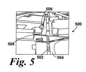
[0061] Figures 5-9 illustrate example embodiments of the present application.
[0062] As shown in Figure 5, an example display 500 for display on a display
device 240 of a portable navigation device 200 is illustrated. The example
display
500 includes map information, which realistically represents the field of view
defined by the display device 240. In use, a user provides an input to the
portable
navigation device 200 selecting a desired destination. The portable navigation
device 200 receives the input from the user via the input device 220. The
display
device 240 displays the map information including a route between the start
position (current position of the portable navigation device 200 obtained via
GPS
for example) and the desired destination (input or selected by a user for
example).
The route is included in example display 500 and referenced 502. The map
information also includes a ground level 504. It should be appreciated that
the
input device 220 and the display device 240 can be included in an integrated
input
and display device 290 in embodiments of the present application.
[0063] The map information also includes an icon 506. The icon 506 is elevated
above the ground level 504 included in the map information of the example
display
500. The icon 506 represents an object within the field of view of the example
display 500. By elevating the icon 506 above the ground level 504, a user of
the
portable navigation device 200 may better view the location of the object
represented by the icon 506 relative to the route or map information, such as
buildings, displayed on the display device 240. As shown in the example
display of
Figure 5, the icon 506 illustrated represents a home location. An input
designating
the home location is received by the portable navigation device 200, through
an
input from the user or a pre-programmed setting. In response to the input, the
portable navigation device 200 elevates an icon representing the home location
when the home location is within the field of view corresponding to the map
13
CA 02720303 2010-09-30
WO 2009/132677 PCT/EP2008/003701
information displayed on the display device 240 (wherein the processor 210 may
control display of this information by, for example, determining when the home
location is within the field of view of the map information currently
displayed, the
current map information display being based upon the current location of the
navigation device 200 and the determined route of travel).
[0064] Objects represented by at least one icon in map information can
include,
for example, any object included content of an actual view of the area
represented
by the map information. Specifically, an object may include for example a
start
point, a present location, a desired destination, any point along a route
(e.g., an
exit ramp), a user designated location, a point of interest, a home location,
a
favorite location, a building, a structure, a waterway, an itinerary waypoint,
route
instructions, traffic equipment (e.g., a traffic light, a traffic camera, a
sign, etc.), or
another object within the field of view or related to an instruction regarding
a route
displayed by a portable navigation device. Specifically, a point of interest
may
include but is not limited to any one of a government office, a mountain peak,
open
parking, a parking garage, a petrol station, a railway station, a rest area,
an
airport, a car dealership, a casino, a church, a cinema, a city centre, a
company, a
concert hall, a courthouse, a cultural centre, a exhibition centre, a ferry
terminal, a
border crossing, a golf course, a hospital/clinic, a hotel, a motel, a tourist
attraction, a mountain pass, a museum, an art gallery, an opera house, an
opera,
a place of worship, a post office, a shipping company, a car rental facility,
a
restaurant, a shop, a mall, a shopping centre, a stadium, a sports arena, a
theatre,
a tourist information office, a zoo, a sports centre, a police station, a
firehouse, an
embassy, a college or university, a cash dispenser, a beach, an ice skating
rink, a
tennis court, a water sport, a doctor, a dentist, a veterinarian, nightlife,
an
amusement park, a library, a car repair/garage, a pharmacy, a scenic view, a
panoramic view, a swimming pool, a winery, a distiller, a camping ground, a
park
and recreation area, a convention center, a leisure centre, a marina, a yacht
basin,
a postcode, a legislator, a lawyer, a solicitor, a counselor, etc.
[0065] It should be appreciated that, in other embodiments of the present
application, one or more objects may be represented by an icon elevated above
a
ground level in the map information and one or more objects may be represented
by an un-elevated icon in the same map information. The determination of which
14
CA 02720303 2010-09-30
WO 2009/132677 PCT/EP2008/003701
icons are elevated may be provided by a user, a portable navigation device
200, or
some combination of the user and the portable navigation device 200.
[0066] In the example display 500, the icon 506 is displayed as positioned at
an
end of a pole 508. The other end of the pole 508 extends to the ground level
504.
The pole 508 extends to the ground level 504 at a position in which the object
represented by the icon would be positioned within in the map information, but
for
the icon being elevated (i.e., the objects position within the field of view).
In this
particular embodiment, the pole 508 is just taller than a tallest building
within the
map information. In this manner, the user is able to understand the position
of
the object, represented by the icon, relative to the map information displayed
in the
display device 240. In other embodiments of the present application, another
marking, three-dimensional or two-dimensional, and height of marking may be
used to extend from the ground level to the icon. For example, a marking
(e.g., a
dotted line of a standard height) may be included between the icon and a
ground
level location of an object represented by the at least one elevated icon
within the
map information.
[0067] In the example display 500, the icon is two-dimensional. In at least
embodiments of the present application, when an icon is displayed as two-
dimensional, a portable navigation device 200 may display the icon via
billboarding. When an icon is displayed via billboarding, the icon 506 is
displayed
such that the icon 506 is visible to the user regardless of an orientation of
an
object represented by the icon 506 on portable navigation device 200 (compare
Figures 5 and 6A-B). As a user proceeds along the route from Figure 5 to
Figure
6A, the user turns at corner 602. When the user turns, the orientation of the
user
to the icon 506 is changed so that, the icon 506 "faces" the user. In this
manner,
the icon 506 is visible to the user regardless of the orientation of the
object.
[0068] In at least one other embodiment of the present application, an icon
may
be a three-dimensional icon. When a three-dimensional icon is used,
orientation of
the icon may be preserved relative to map information included in a display.
In
this manner, regardless of the direction of a user's view, the user can view
the
proper orientation of the icon. For example, when the back of an object would
be
visible from a user's current location, a three-dimensional icon representing
the
object may be elevated and displayed such that the back of the three-
dimensional
CA 02720303 2010-09-30
WO 2009/132677 PCT/EP2008/003701
icon is visible to the user via display device 240. When the user's location
changes,
the orientation of the three-dimensional icon is preserved relative to the map
information, not the user. Accordingly, the user is able to view the three-
dimensional icon (from the side, front, back, etc.) as the object would be
viewed
from the user's location in the actual field of view. It should be appreciated
that
the orientation of a two-dimensional icon may be preserved relative to the map
information and the orientation of a three-dimensional icon may be displayed
via
billboarding in other embodiments of the present application.
[0069] Further, an icon included in an embodiment of the present application
may be related to an object, which the icon represents. As shown in Figure 5,
icon
506 represents a home location. The icon 506 used to represent the home
location
is a generic house. In other embodiments of the present application, an icon
may
be unrelated to the nature or content of the object, which the icon
represents. For
example, as shown in Figure 7, a star icon 700 represents a favorite location,
an
ice cream store. The star does not does not physically represent the favorite
place,
but instead, is assigned by a user. Other generic icons (e.g., heart, cross,
exclamation point, smiley face, letter, etc.) may be include to represent one
or more
objects, as assigned by a user and/or preprogrammed into a portable navigation
device 200. In still other embodiments, an icon may be a replica of the
object's
physical appearance. In this manner, various views of the icon may be viewable
within the map information. In still other embodiments of the present
application,
an icon can be animated. For example, a countries flag may be used to
represent
an embassy for a particular country. As displayed on the portable navigation
device 200, the flag icon can be animated, such that the flag waves in the
wind.
Other icons may be animated in other embodiments, such as a desired
destination
icon represented by a waving checkered flag. Also, map information including a
shadow associated with an icon. The shadow may be included to aid a user in
identifying a location of an object and/or further distinguish the icon from
other
map information displayed on the display device 240.
[0070] It should be appreciated that different types of icons (e.g., generic,
replica,
animated, two-dimensional, three-dimensional, or some combination thereof) may
be employed, lone or in combination, in various embodiments of the present
application.
16
CA 02720303 2010-09-30
WO 2009/132677 PCT/EP2008/003701
[0071] As multiple icons may be displayed on the display device 240, the map
information displayed may become obscured by one or more icons. Accordingly,
one or more icons may be altered to preserve the visibility of map information
to
the user. In at least one embodiment of the present application, an icon may
become transparent based on screen coverage of the icon. As shown in Figure 8,
an example display 800 includes an icon 802, which is partially transparent
such
that the map information behind the icon is visible. In this example, because
the
screen coverage exceeds seventy-five (75) pixels, the icon has been reduced to
50%
visibility (i.e., 50% transparency). It should be appreciated that in other
embodiments, a different number of pixels may be employed to determine a
different transparency for a particular icon displayed on a portable
navigation
device 200. For example, an icon may start to become transparent at 50 pixels,
and become increasingly transparent as the number of pixels covered increases.
In
this example, at 100 pixels screen coverage, the icon becomes totally
transparent.
[0072] In at least one other embodiment of the present application, an icon
may
become transparent based on a distance of the icon from a determined route of
travel (the route being determined based upon an initial location of the
navigation
device 200 and an input or selected final destination, for example). The icon
becomes transparent at some minimum distance from the route of travel, and
continues to become transparent until some maximum distance from the route of
travel. At the maximum distance, the icon becomes totally transparent. For
example, an icon representing an object more than a certain number of miles
from
a route of travel may be completely transparent; while an icon representing an
object a different number of miles from the route of travel may be only a
certain
percentage visible. In this example, at a certain number of miles, the icon
becomes
totally visible.
[0073] It should be appreciated that the transparency of an icon may be
cumulatively altered based on more than one of the conditions described above
and/or below. For example, an icon may become transparent based on screen
coverage of icon and distance of the icon from the route of travel. For an
icon
covering 75 pixels (50% visible, 50% transparent) and one mile from the route
of
travel (50% visible, 50% transparent), the icon would be displayed as 25%
visible
(50% visible x 50% visible = 25% visible) within the map information.
17
CA 02720303 2010-09-30
WO 2009/132677 PCT/EP2008/003701
[0074] Alternatively or additionally, the size of an icon may be altered to
preserve
visibility of map information displayed on displayed device 240 of portable
navigation device 200. In at least one example, the size of an icon may be
based on
the distance of the icon from the route of travel. For objects closer to the
route, an
icon representing the object may be larger than an icon representing an object
further away from the route, such that a user can distinguish between objects.
In
one example, a user may select a fuel station represented by an larger icon,
i.e.,
closer to the route. By icon size indications, a user may easily choose to
visit
objects closest to the route to minimize impact on reaching the desired
destination.
It should be appreciated that size of an icon may indicate other conditions
for the
objects represented by the icon in other embodiments of the present
application.
For example, in the context of fuel stations, larger icons may indicate a user
preferred brand of fuel.
[0075] As shown in Figure 9, an example display 900 includes a plurality of
icons. As the number of icon increases, the amount of map information
displayed
on a display device 240 may be decreased. In at least one embodiment of the
present application, a portable navigation device 200 may limit the number of
icons in the map information to a predetermined number. For example, a
portable
navigation device 200 may be preprogrammed with a predetermined number of a
twenty-five (25) icons. When more than 25 icons are within the map
information,
the portable navigation device 200 displays only the predetermined number of
icons closest to the portable navigation device. Thus, the twenty-five icons
closest
to the portable navigation device 200 are displayed on the display device 240.
In
another embodiment, a portable navigation device 200 may display the
predetermined number of icons based on a different criteria, such as proximity
to a
route of travel, proximity to a desired destination, proximity to point of
interest,
classification of an object represented by an icon (e.g., display all favorite
locations
first), etc.
[0076] Further, in at least one embodiment of the present application, an icon
is
positioned on one end of a pole with the other end extending to the ground
level.
As described above, the location at which the pole intersects the ground level
is the
position of the object within the field of view. Depending on the map
information
displayed, the location at which the pole intersects the ground level may be
18
CA 02720303 2010-09-30
WO 2009/132677 PCT/EP2008/003701
obstructed. In such a condition, the icon may be less helpful to a user than a
fully
viewable icon. Accordingly, the partially obscured icon may be omitted to
display
fully viewable icons and/or maximize the amount of map information displayed
on
display device 240. In other embodiments of the present application, one or
more
of the methods described above with reference to multiple icons may be
employed
to preserve the display of map information and/or at least one icon.
[0077] The embodiment of the present application discussed above included a
navigation device 200, which is a portable navigation device. However, the
embodiments, methods and devices explained above are not limited as such.
Aspects, embodiments, methods and devices explained above are further
applicable
to a navigation device, which is integrated into a vehicle. Such a navigation
device
may be, for example, integrated into a dashboard or other portion of a
vehicle.
Such a vehicle may include, but is not limited to a car, truck, boat,
motorcycle, etc.
In at least one embodiment, such a navigation device integrated in a vehicle
may
be used to perform the various aspects of the method described with regard to
Figure 5, as would be understood by one of ordinary skill in the art. Thus,
further
explanation is omitted for the sake of brevity.
[0078] Even further, any of the aforementioned methods may be embodied in the
form of a program. The program may be stored on a computer readable media and
is adapted to perform any one of the aforementioned methods when run on a
computer device (a device including a processor). Thus, the storage medium or
computer readable medium is adapted to store information and is adapted to
interact with a data processing facility or computer device to perform the
method of
any of the above mentioned embodiments.
[0079] The storage medium may be a built-in medium installed inside a
computer device main body or a removable medium arranged so that it can be
separated from the computer device main body. Examples of the built-in medium
include, but are not limited to, rewriteable non-volatile memories, such as
ROMs
and flash memories, and hard disks. Examples of the removable medium include,
but are not limited to, optical storage media such as CD-ROMs and DVDs;
magneto-optical storage media, such as MOs; magnetism storage media, including
but not limited to floppy disks (trademark), cassette tapes, and removable
hard
disks; media with a built-in rewriteable non-volatile memory, including but
not
19
CA 02720303 2010-09-30
WO 2009/132677 PCT/EP2008/003701
limited to memory cards; and media with a built-in ROM, including but not
limited
to ROM cassettes; etc. Furthermore, various information regarding stored
images,
for example, property information, may be stored in any other form, or it may
be
provided in other ways.
[0080] The methods of at least one embodiment expressed above may be
implemented as a computer data signal embodied in the carrier wave or
propagated
signal that represents a sequence of instructions which, when executed by a
processor (such as processor 304 of server 302, and/or processor 210 of
navigation
device 200 for example) causes the processor to perform a respective method.
In at
least one other embodiment, at least one method provided above may be
implemented above as a set of instructions contained on a computer readable or
computer accessible medium, such as one of the memory devices previously
described, for example, to perform the respective method when executed by a
processor 210 or other computer device. In varying embodiments, the medium
may be a magnetic medium, electronic medium, optical medium, etc.
[0081] As one of ordinary skill in the art will understand upon reading the
disclosure, the electronic components of the navigation device 200 and/or the
components of the server 302 can be embodied as computer hardware circuitry or
as a computer readable program, or as a combination of both.
[0082] The system and method of embodiments of the present application
include software operative on the processor to perform at least one of the
methods
according to the teachings of the present application. One of ordinary skill
in the
art will understand, upon reading and comprehending this disclosure, the
manner
in which a software program can be launched from a computer readable medium
in a computer based system to execute the functions found in the software
program. One of ordinary skill in the art will further understand the various
programming languages which may be employed to create a software program
designed to implement and perform at least one of the methods of the present
application.
[0083] The programs can be structured in an object-orientation using an object-
oriented language including but not limited to JAVA, Smalltalk, C++, etc., and
the
programs can be structured in a procedural-orientation using a procedural
language including but not limited to COBAL, C, etc. The software components
CA 02720303 2010-09-30
WO 2009/132677 PCT/EP2008/003701
can communicate in any number of ways that are well known to those of ordinary
skill in the art, including but not limited to by application of program
interfaces
(API), interprocess communication techniques, including but not limited to
report
procedure call (RPC), common object request broker architecture (CORBA),
Component Object Model (COM), Distributed Component Object Model (DCOM),
Distributed System Object Model (DSOM), and Remote Method Invocation (RMI).
However, as will be appreciated by one of ordinary skill in the art upon
reading the
present application disclosure, the teachings of the present application are
not
limited to a particular programming language or environment.
[0084] The above systems, devices, and methods have been described by way of
example and not by way of limitation with respect to improving accuracy,
processor
speed, and ease of user interaction, etc. with a navigation device 200.
[0085] Further, elements and/or features of different example embodiments may
be combined with each other and/or substituted for each other within the scope
of
this disclosure and appended claims.
[0086] Still further, any one of the above-described and other example
features
of the present invention may be embodied in the form of an apparatus, method,
system, computer program and computer program product. For example, of the
aforementioned methods may be embodied in the form of a system or device,
including, but not limited to, any of the structure for performing the
methodology
illustrated in the drawings.
[0087] Example embodiments being thus described, it will be obvious that the
same may be varied in many ways. Such variations are not to be regarded as a
departure from the spirit and scope of the present invention, and all such
modifications as would be obvious to one skilled in the art are intended to be
included within the scope of the following claims.
21