Note: Descriptions are shown in the official language in which they were submitted.
CA 02723196 2010-11-30
TRAFFIC PROFILING AND ROAD CONDITIONS-BASED
TRIP TIME COMPUTING SYSTEM WITH LOCALIZED
AND COOPERATIVE ASSESSMENT
BACKGROUND OF THE INVENTION
This application relates to trip time computation, and more specifically to a
system for computing trip time that includes traffic profiling and road
condition-
based computation with localized and cooperative assessment.
Previous traffic determination systems have estimated traffic using
triangulated positioning of cell phones to determine a speed at which a cell
phone
moves. There are many limitations and drawbacks in the current systems. For
example, if a phone moves quite slowly, it may be assumed that a driver
carrying the
phone is driving in traffic.
SUMMARY OF THE INVENTION
This invention localizes traffic condition detection and classification to a
vehicle. Vehicles work cooperatively to fuse their traffic condition
assessments so as
to produce larger geographical coverage and more reliable evidence of the
conditions. The system can be executed on an onboard device which includes at
least one of the following: GPS capabilities, connection connected to the
vehicle to
measure vehicle speed, or communication (or integration) with a cell phone. In
the
example of the cell phone, speed can be computed from phone GPS, a
GPRS/CDMA, or both. Otherwise, vehicle speed can be determined obtained from
in-vehicle on-board diagnostic system (e.g. using the OBD-II protocol) or
based on
GPS and accelerometer readings.
These and other features of the present invention can be best understood
from the following specification and drawings, the following of which is a
brief
description.
1
CA 02723196 2010-11-30
BRIEF DESCRIPTION OF THE DRAWINGS
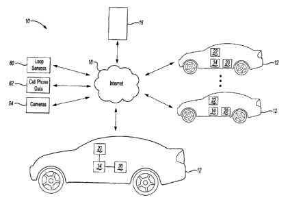
Figure 1 schematically illustrates a traffic profiling system.
Figure 2 schematically illustrates an onboard device for a vehicle in the
system of Figure 1.
Figure 3 schematically illustrates an example traffic index.
DETAILED DESCRIPTION OF THE PREFERRED EMBODIMENT
Figure 1 schematically illustrates a traffic profiling system 10. A vehicle 12
includes an onboard traffic conditions computer 14 (hereinafter "onboard
device").
In one example the onboard device 14 includes some or all of the features in
the
commercially available iLane product (see http://www.iIane.ca/), also
described in
co-pending application U.S. Pat. App. 20090318119, filed June 19, 2009, which
is
hereby incorporated by reference in its entirety. A server 16 is operable to
communicate wirelessly with the onboard device 14 via a wide-area network,
such
as the Internet 18, or a private network or channel. Similar onboard devices
14 are
installed on numerous vehicles 12 in the same geographic area and also
communicate with the server 16. The server 16 may also receive traffic
information
from loop sensors 60, cell phone data 62, cameras 64 or other known sources of
traffic information, which can be fused with information from the onboard
devices
14.
The onboard device 14 is schematically illustrated in greater detail in Figure
2. The onboard device 14 includes a road database 44 and a speed limit
database 46
indicating speed limits on the road segments in the road database 44. The road
database 44 and speed limit database 46 may be pre-stored on the onboard
device 14
or downloaded and/or updated from the server 16. If the road database 44 and
speed
limit database 46 are downloaded and/or updated from the server 16, they may
be
downloaded and/or updated only for roads in the vicinity of the vehicle 12.
The
vicinity may be defined as an area around the vehicle 12 which is set to be
dependent on density of roads and density of populations (e.g., the higher the
density
the smaller is the area).
The onboard device 14 includes a processor 52 and storage for storing the
data and programs to perform the functions described herein. The onboard
device
2
CA 02723196 2010-11-30
14 may include a GPS receiver 48, or may receive GPS location from a cell
phone or
other mobile device 22 (Figure 1). The onboard device 14 includes an OBD port
50
for receiving on-board diagnostic information from an OBD port (or OBD-I1 or
any
other protocol) on the vehicle 12. A mobile device communication module 40
provides wireless (or alternatively, wired) communication with the mobile
device 22
to provide communication to the server 16 and to obtain information from the
mobile device 22 itself (contacts, email, GPS location information, etc). The
onboard device 14 may also include one or more wireless transceivers 54 to
communicate directly with cell towers to access the Internet 18 and/or with
wireless
transceivers 54 on other vehicles 12. The onboard device 14 further includes a
microphone 56 for receiving voice commands from a user and a speaker 58 for
giving audible information to the user. The speaker 58 could alternatively be
part of
the vehicle 12 audio system. The onboard device 14 preferably communicates
with
the user primarily via voice, although a display output module 38 for sending
information to a display 20 could also be provided. Thus, the onboard device
14
includes a speech recognition module 34 and a text-to-speech module 36.
Although the vehicle 12 is illustrated as being an automobile, it is
understood
that the onboard device 14 could be applied to other vehicles too, such as
motorcycles, bicycles, etc.
Since the onboard device 14 may be used by a vehicle operator (e.g. a
driver), by a vehicle passenger (e.g. limousine passenger), or by another
party, the
term "user" will be used to refer to a person interacting with the onboard
device 14.
Localized Assessment
The system 10 determines its location relative to the database of roads 44
based upon (for example) the GPS location information and then obtains the
current
speed limit of the current road segment from the speed limit database 46. The
onboard device 14 determines its current speed based upon information from the
GPS receiver 48 and/or from the speed information available on the OBD 50
and/or
from an accelerometer on the onboard device 14. The onboard device 14 compares
the current speed limit with the current estimated speed of the vehicle 12,
and
computes a traffic condition index based on the comparison of speed with the
speed
limit, and indexed to position, as shown in Figure 3. The index is one of a
number of
3
CA 02723196 2010-11-30
traffic condition classes (see, e.g., Fig. 3). If at the time the traffic
index matches
some traffic conditions criteria, a spatio-temporal profile of the traffic
index is
transmitted to the server 16. For example, if the index indicated the presence
of
traffic congestion, then a message is sent to the server 16 indicating a
traffic
congestion event along with the profile. The message includes the time, road
segment, location and current speed.
Thus, the onboard device 14 is operable to perform a "localized assessment"
on the vehicle 12 of traffic (e.g., comparing a speed limit to a current
vehicle speed).
Cooperative Assessment
The onboard device 14 is responsive to voice commands via speech
recognition module 34 (see Fig. 2). In one example, a user who recognizes a
traffic
congestion event can choose to send a traffic profile report alert to the
server 16 by
using a voice command to tell the onboard device 14 to send a traffic report
alert to
the server 16 in the form of a natural language sentence such as "very heavy
road
congestion," "congestion due to an accident," "congestion due to slippery
conditions," etc. The onboard device 14 will send the sentence along with a
time and
a location of the vehicle 12.
In this example, the server 16 parses the sentences it receives to estimate
the
traffic condition in and around the reported location of the report. An
algorithm at
the server 16 is used to process the parsed sentences to compute a traffic
conditions
profile throughout the road network and to determine and eliminate outlier
reports or
incorrect reports. A similar algorithm may be used to process the traffic
condition
indices in the "Localized Assessment" section above.
Thus, the onboard device 14 is also operable to perform a "cooperative
assessment" because there is some interaction or discourse between the onboard
device 12 and the user to assess traffic conditions.
Merging of Traffic Data from Multiple Sources
Whenever possible, the server 16 may fuse the parsed sentences from many
users for the area and reported indices from many vehicles 12 for the area to
compute a reliable and explainable traffic condition for a traffic segment,
leading to
determination of the traffic conditions in the area. Furthermore, this
information may
be fused with traffic data obtained from other sources, such as loop sensors
60,
4
CA 02723196 2010-11-30
cameras 64, and GSM-mobility data 62. Such diverse multi-source reports allow
for
high confidence and more accurate traffic conditions estimation. The server 6
may
process parsed sentences (the cooperative assessments) and indices (the
localized
assessments) collected from multiple vehicles 12 to establish time and
contextual
statistical traffic record for an area, and to ensure accuracy of traffic
data.
Road Condition Inquiries from Onboard Device
The onboard device 14 can send inquiries about road conditions on a certain
road segment to the server 16. Based on the processed reported sentences and
indices received from multiple vehicles 12, the server 16 can send the
inquirer a
response indicating the traffic condition of the area. Also, in this case
other traffic
profiling data from GPRS/GSM and loop sensors may be used to compose a report.
If no report or index is available for the area then a message is sent to the
onboard
device 14 indicating such condition (e.g., a "no incident" or "no data
available"
response is sent to the onboard device 14). The onboard device 14 conveys the
information to the operator of the vehicle 12 using voice (using Text to
Speech
module 36 in Fig. 2) or congestion color code road map on a display 20 (using
Display Output module 38 in Fig. 2). Of course, other reporting methods would
be
possible. This information may also be reported on a web portal for viewing
(e.g. on
the display 20).
Selective Transmission of Traffic Alerts
The server 16 may receive traffic condition reports from many vehicles 12,
and the server 16 continuously processes those reports to determine traffic
alerts.
Onboard devices 14 may be used to navigate the user via a calculated route to
a
destination. The destination of the vehicle 12 may otherwise be known or may
be
deduced (e.g. based upon driving patterns, such as driving home after work on
weekdays). The server 16 determines the vehicles 12 who are affected by the
alert
(based upon their current locations and based upon the known or assumed
destinations) and sends the alerts to those affected vehicles. Additionally,
or
alternatively, where the destination is not known, road segments in the area
in the
direction that the vehicle 12 is heading are considered relevant. For example,
based
on destination and location of vehicle 12, an alert may be sent to the vehicle
12.
5
CA 02723196 2010-11-30
Vehicles not affected by the condition are not bothered and the server 16 may
choose to not even send the report to those vehicles.
Trip Time Computation
If a vehicle 12 operated has programmed their destination into the onboard
device 14 or the server 16, then the trip time to the destination may be
computed
based on routing data and traffic conditions on the route. The onboard unit 14
or the
server 16 determine a sequence of road segments, which can be computed onboard
or can be obtained from a generic routing service provider such as MapQuest.
The
onboard unit 14 or the server 16 then checks if a road segment is affected by
a
congestion situation. If a segment is determined to be affected by a traffic
congestion event, the travel time for the segment may be recomputed and the
trip
time to destination may be updated, and the user may be informed of the
updated
trip time (e.g. via Text to Speech module 36). Alternatively, if a segment on
the
route is determined to be affected by a traffic congestion event, then the
route can be
recalculated to avoid the congested segment.
Timed Event Functionality
If the user programs a timed event (e.g. such as a meeting, can be fetched
from calendar on mobile device 22), the onboard device 14 may provide a proper
warning on the possibility of missing the meeting (e.g. providing a computer
generated speech message to the user). The onboard device 14 may offer to call
the
meeting inviter to allow the user to notify the meeting inviter of a possible
delay, or
may offer to transmit an email message or a text message to the user to
provide the
notification. The call, email, or text message may be performed using a mobile
device 22 that the onboard device 14 communicates with via Mobile Device
Communication module 40.
The onboard device 14 may suggest to the user a superior route to the
destination that would exhibit less traffic. Thus, the onboard device 14 may
perform
a less traffic congestion routing feature.
If the user enters a meeting location and time in his mobile device 22 or
office computer calendar, the system 10 will continue to monitor traffic
conditions
that affect the roads between the user's current location and that where the
meeting
will take place. If the onboard device 14 or server 16 determine that a
difference
6
CA 02723196 2010-11-30
between the present time and that when the meeting will take place is becoming
critically tight for the user to travel to the meeting place, a warning may be
sent to
the user on his computer or mobile phone 22 to warn him/her that timing is
getting
tight for them to make it to the meeting. The user can add some safety factors
in the
form of extra time (e.g., if it takes 2 hours to travel to the meeting place,
and the
difference between the present time and the meeting starting time is 2 hours,
the user
may ask the system to allow for 30 minutes extra, and the system 10 may
provide
the warning 30 minutes before the present time).
Information Sharing
In addition to uploading a traffic profile report to the server 16, the system
10
may use short range communication capabilities of the transceiver 54 of the
onboard
device 14 to broadcast to vehicles in its vicinity the presence of traffic
congestion.
Thus, in one example, traffic information may be shared directly between
onboard
devices 14 in vehicles within a predefined proximity to each other.
Alternatively,
the information could be transmitted via the Internet or even via the server
16
(although, without filtering or fusion with other sources) between other
onboard
devices 14 within a radius of one another.
Information Weighting
Since the server 16 receives information about traffic from multiple vehicles
12 and other sensors 60, 62, 64, the server 16 may assign weights of evidence
to the
different sources and combine the information from the different sources and
assign
a weight of evidence (or confidence factor) on the traffic condition.
Abstraction of Traffic Conditions
In one example, the system 10 employs multi-level abstraction of traffic
conditions of a road segment that ranges from numerical traffic data such as
speed
(e.g., "Current speed on road segment is 70 km/hour") to linguistic natural
language
traffic descriptors (e.g., "Traffic condition on the road segment is very
slow"). A
Fuzzy Logic Engine 42 (see Fig. 2) may be used to produce linguistic traffic
descriptors from speed range measurements.
The Fuzzy Engine 42 allows the user to discourse with the onboard device 14
inquire about the traffic conditions. For example, the user can ask questions
such as
traffic conditions on current road on which the vehicle is being driven. The
system
7
CA 02723196 2010-11-30
will scan the road and report using natural language traffic conditions at
high
level (e.g. "traffic is slow," or "somehow slow," or "very slow," or "smooth
on a
road segment"). The user can ask questions to the onboard device 14 (e.g.,
"Tell me
traffic conditions on east bound," "Tell me traffic conditions on north
bound," etc.).
5 The onboard device 14 can take the name of a road uttered via voice by the
user to a
segment on the road or the whole road. For example, the system can determine
based on vehicle location the interpretation of east bound relative to the
vehicle
location. That is, the system 10 can use the location and/or direction of
vehicle 12
movement to determine relevant segment of the road that the user is interested
in.
10 The user can ask the system to provide more detailed information (e.g. by
asking
"How slow?"). Where the system 10 provides a current speed range on the
segment
(e.g., "Traffic is moving with speed between 40 to 50 km an hour"), the user
can ask
a question in response (e.g. "How bad is traffic on the segment?). The system
10 can
answer with a speed range and possible a duration for which that speed range
has
been experienced by other users. The system can also say speed is starting to
pick
up. The user can set an alert flag, such that the system 10 will monitor
traffic on the
trip path and report emerging deteriorating/improving traffic conditions.
Although a preferred embodiment of this invention has been disclosed, a
worker of ordinary skill in this art would recognize that certain
modifications would
come within the scope of this invention. For that reason, the following claims
should be studied to determine the true scope and content of this invention.
8