Note: Descriptions are shown in the official language in which they were submitted.
CA 02723225 2010-10-26
WO 2009/135151 PCT/US2009/042563
SYSTEM FOR USING IMAGE ALIGNMENT TO MAP OBJECTS ACROSS DISPARATE IMAGES
PRIORITY
[0001] This application claims priority to U.S. Provisional Patent
Application,
Serial No. 61/049954 filed May 2, 2008 and which is hereby incorporated in its
entirety
by reference.
FIELD OF THE INVENTION
[0002] The invention relates to a system and method for mapping still or
moving images of different types and/or different views of a scene or object
at the same
or different points in time such that a specific object or location in the
scene may be
identified and tracked in the respective images. The system and method may be
applied
to virtually any current or future image types, both 2-D and 3-D, both single-
frame and
multi-frame (video). The system and method also may be used in association
with any
known method of image alignment by applying the same form of transformation to
images as applied by that image alignment method.
BACKGROUND OF THE INVENTION
[0003] There are many instances where it is necessary to precisely pinpoint a
specific location in one image within another, different image of the same
subject matter.
These images may be different types (e.g., x-ray, photograph, line drawing,
map, satellite
image, etc.), similar image types taken from different perspectives (e.g.,
different camera
angle, rotation, focal length or subject-focal plane relationship), similar or
different
images taken at different points in time, or a combination of all of these.
The techniques
described herein may be used with such imaging types or other imaging types
that
capture and present images of 3-D space (e.g., CAT and MRI, which use multiple
2-D
1
CA 02723225 2010-10-26
WO 2009/135151 PCT/US2009/042563
slices) or that create 3-D renderings from 2-D images (e.g., stereoscopic
slides such as
are used in the current ophthalmology image comparison gold standard or "3-D"
technologies such as used in entertainment today). The image types may also
include
video and film, which are composed of individual images (2-D or stereoscopic).
[0004] Today, the options for achieving this mapping of such images are
limited. A user may (1) estimate using various visual and intuitive
techniques, (2)
estimate using mathematical techniques, or (3) use computer image morphing
techniques
to align and overlay the images using, e.g., flicker chronoscopy, which is
used in many
other disciplines such as engineering and astronomy to identify change or
motion. Each
of these techniques has important shortcomings, including relatively low
accuracy, being
slow or time consuming, requiring high levels of skill or specialized
knowledge, and
being highly prone to error. An improved technique without such shortcomings
is
desired.
SUMMARY OF THE INVENTION
[0005] The cross-image mapping (CIM) technique of the invention is designed
to increase the ease, speed and accuracy of mapping objects across images for
a variety of
applications. These include - but are not limited to - flicker chronoscopy for
medical
tracking and diagnostic purposes, cartographic applications, tracking objects
across
multiple sequential images or video frames, and many others.
[0006] The CIM technique of the invention makes it possible to locate specific
coordinates, objects or features in one image within the context of another.
The CIM
technique can be applied to any current or future imaging technology or
representation,
whether 2-D or 3-D, single-frame (still) images or multi-frame (video or other
moving
image types). The process can be easily automated, and can be applied in a
variety of
ways described below.
[0007] In an exemplary embodiment, the CIM technique of the invention
generally employs three broad steps:
1. establishing a relationship between two images by morphing or,
alternatively,
mapping one or more images in a set to align them and to generate associated
morphing
or mapping parameters or, alternatively, to generate mapping parameters
without first
performing an alignment using a matching algorithm or manual mapping through a
2
CA 02723225 2010-10-26
WO 2009/135151 PCT/US2009/042563
landmark tagging application such as those used in other contexts (e.g., photo
morphing
applications that transform one face into another);
2. establishing formulae for mapping from a given input image to a given
aligned
or unaligned output image or vice-versa; and
3. applying the mapping and/or alignment parameters to identify and highlight
the
pixel in one image corresponding to the comparable location in another (i.e.,
identify the
pixel that shows the same location relative to some landmark in each image).
[0008] In the first step, actual morphing or modification of the images need
not
be applied if the landmark tagging is to or from an unaligned image rather
than between
aligned images. In such cases, the important output of an alignment algorithm
is the
formulae, not the modified images themselves.
[0009] The method may also include the ability to indicate the accuracy or
reliability of mapped pixel locations. This accuracy or reliability assessment
may be
based on outputs or byproducts of the alignment algorithm(s) or tool(s)
employed in the
mapping, or on assessment of aligned images after the fact. Such accuracy or
reliability
measures may be presented in many ways, including but not limited to visual
modification of the mapped marking (through modification of line thickness,
color, or
other attributes) and quantitative or qualitative indicators inside or outside
of the image
area (e.g., red/yellow/green or indexed metrics).
[0010] The scope of the invention includes a method, computer system and/or
computer readable medium including software that implements a method for
mapping
images having a common landmark or common reference point (e.g., global
positioning
system tags, latitude/longitude data, and/or coordinate system data) therein
so as to, for
example, enable the creation, location and/or mapping of pixels, coordinates,
markings,
cursors, text and/or annotations across aligned and/or unaligned images. The
computer-
implemented method includes selecting at least two images having the common
landmark
or common reference point, mapping the selected images so as to generate
mapping
parameters that map a first location on a first image to the corresponding
location of the
first location on a second image, and identifying at least one pixel on the
first image and
applying the mapping parameters to at least one pixel on the first image to
identify the
corresponding pixel or pixels in the second image. The mapping parameters then
may be
3
CA 02723225 2010-10-26
WO 2009/135151 PCT/US2009/042563
used to locate or reproduce any pixels, coordinates, markings, cursors, text
and/or
annotations of the first image at the corresponding location of the second
image.
[0011] In an exemplary embodiment, the two images maybe of different image
types including: x-ray image, photograph, line drawing, map image, satellite
image, CAT
image, magnetic resonance image, stereoscopic slides, video, and film. The
images also
may be taken from different perspectives and/or at different points in time.
The images
may be aligned using an automated image matching algorithm that aligns the
first and
second images and generates alignment parameters, or a user may manually align
the first
and second images by manipulating one or both images until they are aligned.
Manual or
automatic landmark mapping may also be used to identify the common landmark in
the
first and second images. In the case of automated landmark mapping, associated
software may generate mapping parameters based on the locations in the first
and second
images of the common landmark. In addition, the first image may be morphed to
the
second image whereby the common landmark in each image has the same
coordinates.
[0012] In the exemplary embodiment, an indication of a degree of accuracy of
the
alignment and/or mapping of the selected images at respective points in an
output image
may also be provided. Such indications may include means for visually
distinguishing
displayed pixels for different degrees of reliability of the alignment and/or
mapping of
the display pixels at respective points. For example, different colors or line
thicknesses
may be used in accordance with the degree of reliability of the alignment
and/or mapping
at the respective points or, alternatively, a numerical value for points on
the output image
pointed to by a user input device. The mapping may also be extended to pixels
on at least
one of the images that is outside of an area of overlap of the first and
second images.
BRIEF DESCRIPTION OF THE DRAWINGS
[0013] The foregoing summary, as well as the following detailed description of
various embodiments of the present invention, will be better understood when
read in
conjunction with the appended drawings. For the purpose of illustrating the
embodiments, there are shown in the drawings embodiments which are presently
preferred. It should be understood, however, the embodiments of the present
invention
are not limited to the precise arrangements and instrumentalities shown.
4
CA 02723225 2010-10-26
WO 2009/135151 PCT/US2009/042563
[0014] Figure 1 illustrates images of a single, unchanged object where
unaligned image A illustrates the object as taken straight on from a specific
number of
feet and unaligned image B illustrates the same object from a lower vantage,
further
away, with the camera rotated relative to the horizon, and a different
placement of the
object in the image.
[0015] Figure 2 illustrates how image B is modified to correspond to image A.
[0016] Figure 3 illustrates the mapping parameters for mapping unaligned
image B to unaligned image A.
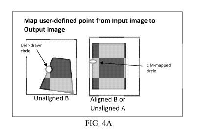
[0017] Figure 4a illustrates the mapping of a user-drawn circle at a user-
defined
location from the input image B to the output image (aligned image B or input
image A).
[0018] Figure 4b illustrates the application of alignment parameters (e.g.
lines)
to the images to indicate shift by mapping "before and after" marks from two
or more
images onto the marked images or other images from the image set.
[0019] Figure 5 illustrates two types of images of the same object where
common identifying features are provided in each image.
[0020] Figure 6 illustrates the alignment of the images of Figure 5 using a
common feature by modifying one or more of the images to compensate for camera
angle, etc. using a manual landmark application or an automated algorithm.
[0021] Figure 7 illustrates the parameters for mapping from one image in a set
to another, based on alignment of the two images (note the parameters are the
same as in
Figure 3 except that the images are not aligned).
[0022] Figure 8 illustrates the mapping of a user-entered input marking in
image
A to image B or aligned image B.
[0023] Figure 9 illustrates an exemplary computer system for implementing the
CIM technique of the invention.
[0024] Figure 10 illustrates a flow diagram of the CIM software of the
invention.
[0025] Figure 11 illustrates the operation of a sample landmark tagging
application in accordance with the invention whereby corresponding landmarks
are
identified in two images either manually or through automation.
CA 02723225 2010-10-26
WO 2009/135151 PCT/US2009/042563
[0026] Figure 12 illustrates the expression of a given "location" or
"reference
point" in an image in terms of a common landmark or by using a convention such
as the
uppermost left-hand pixel in the overlapping area of aligned images.
[0027] Figure 13 illustrates examples of displaying accuracy or reliability in
the
comparison of images using the CIM techniques of the invention.
[0028] Figure 14 illustrates aligned and mapped images in which image A
covers a small portion of the area covered by image B, and illustrates a means
for
identifying coordinates of a landmark in image B relative to image A
coordinate system
but beyond the area covered by image A.
DETAILED DESCRIPTION OF ILLUSTRATIVE EMBODIMENTS
[0029] A detailed description of illustrative embodiments of the present
invention will now be described with reference to Figures 1-14. Although this
description provides a detailed example of possible implementations of the
present
invention, it should be noted that these details are intended to be exemplary
and in no
way delimit the scope of the invention.
Overview
[0030] The CIM technique of the invention employs computer-enabled image
morphing and alignment or, alternatively, mapping through landmark tagging or
other
techniques, as the basis of its capabilities. Specifically, two or more images
are aligned
and/or mapped to each other such that specific landmarks in either image fall
in the same
spot on the other. It is noted that the alignment may be of only part of each
of the
images. For example, the images may depict areas with very little common
overlap, such
as images of adjacent areas. In addition, one image may cover a small area
included in a
second, larger area covered by the second image. Thus, the landmarks or pixels
shown in
the overlap area, though bearing the same relationship to each other in both
images and
ostensibly representative of the same spot in space, might fall in very
different locations
within the image relative to the center, corner or edge. This alignment can be
achieved
by changing one image to match the other or by changing both to match a third,
aligned
image (in the case of multiple input images or video images, the same
principles are
applied several times over) or by mapping the images (mapping one image to
match the
other or by mapping both to match a third, aligned image) to each other
without actually
6
CA 02723225 2010-10-26
WO 2009/135151 PCT/US2009/042563
changing the images. There are currently several ways to do this using
computers,
including manual registration with image manipulation software such as
Photoshop, or
automatically, using technologies such as the Dual Bootstrap algorithm.
However it is
accomplished, the end result is (1) a set of images including two or more
unaligned
images (unaligned image A, unaligned image B, and so on) and two or more
aligned
images (aligned image A, aligned image B, and so on), such that the aligned
images can
be overlaid and only those landmarks that have moved or changed will appear in
different
pixel locations and/or (2) a set of parameters for mapping one or more image
in the set to
another such that this mapping could be used to achieve alignment as in (1).
It is
important to note that the CIM technique is indifferent to the mechanism used
for
aligning or mapping images and does not purport to accomplish the actual
alignment of
images.
[0031] As used herein, "aligning" means to transform a first image so that it
overlays a second image. For example, image alignment may include the
modification of
one or more images to the best possible consistency in pixel dimensions (size
and shape)
and/or location of specified content within the image (e.g., where only part
of images are
aligned).
[0032] As used herein, "mapping" means to identify a mathematical relationship
that can be used to identify spot or pixel in one image that corresponds to
the spot or
pixel in another image. It is not necessary to modify either image to
establish mapping.
For example, mapping is used to create alignment and/or to represent the
operations
performed to achieve alignment. Mapping parameters are the output of the
mapping
operation and are used to perform the calculations of pixel locations when
performing
landmark tagging.
[0033] This technique applies equally well when, for example, the areas
covered
by two images result in only partial overlap as shown in Figure 12. As
illustrated in
Figure 12, a given "landmark" or "reference point" in an image is identified.
In the
mapped pair on the right, a specific location may be identified in either
image relative to
a common landmark, coordinate system, or according to mapping parameters, but
falls in
very different "locations" within the two images (as indicated by relative
location to the
lines bisecting each image). Depending on the mechanics of the alignment
algorithm
7
CA 02723225 2010-10-26
WO 2009/135151 PCT/US2009/042563
and/or the mapping parameters, this common pixel can be located in each image
in any of
several ways, typically (but not limited to) relative to a specified landmark
or relative to a
common reference point or pixel (e.g., uppermost left-hand) in the overlapping
portion of
the images.
[0034] As used herein, an "input image" is the image used to identify the
pixel
or location used for generating mapping, and an "output image" is the image
upon which
the mapped pixel or location is located and/or displayed. Both input and
output images
may be aligned or unaligned.
[0035] As used herein, "landmark tagging" refers to various forms of
identifying common landmarks or registration points in unaligned images,
either
automatically (e.g. through shape recognition) or manually (i.e. user-
identified).
[0036] The CIM technique of the invention first creates formulae for mapping a
specific location within any image in the input or aligned image sets to any
other in the
set. The formulae contain parameters for shifting image centers (or other
reference point)
up/down and left/right, rotating around a defined center point, stretching one
or more
axes or edges or dimensions to shift perspective, and so on. These formulae
can (1) be
captured as part of the output of automated alignment algorithms such as Dual
Bootstrap,
or (2) be calculated using landmark matching in a landmark tagging or other
conventional
application. As described below with respect to Figure 11, the landmark
tagging
application will present the user with two or more images, allow the user to
"tag"
specific, multiple landmarks in each of the images, and use the resulting data
to calculate
the formulae or parameters that enable a computer program to map any given
point in an
image to the comparable point in another image within the set. Alternatively,
landmark
tagging may be achieved through automated processes using shape recognition,
color or
texture matching, or other current or future techniques.
[0037] Once the mapping formulae are established, the user selects two (or
more) images from the image set for mapping. These may be all aligned images,
a mix
of unaligned and aligned images, or all unaligned images. These may be a mix
of image
types, for example drawings and photographs, 2-D video frames and 3-D still or
moving
renderings, etc. (e.g., CAT, MRI, stereoscopic slides, video, or film). The
selected
8
CA 02723225 2010-10-26
WO 2009/135151 PCT/US2009/042563
images are displayed by the landmark tagging application in any of several
ways (e.g.,
side by side, or in overlapping tabs).
[0038] The user may then identify a pixel, feature or location in one of the
selected images (the input image), and the CIM application will identify and
indicate the
corresponding pixel (same object, landmark or location) in the other selected
images
(output images). The manner of identification can be any of several, including
clicking
with a mouse or pointing device, drawing shapes, lines or other markings,
drawing
freehand with an appropriate pointing device, marking hard copies and
scanning, or other
computer input techniques. Selected pixels or landmarks can be identified with
transient
indicators, by translating the lines or shapes from the input image into
corresponding
display in the output image, or by returning coordinates in the output image
in terms of
pixel location or other coordinate system. The input image can be an unaligned
or
aligned image, and the output image(s) can also be either unaligned or
aligned.
Exemplary Embodiment
[0039] In accordance with an exemplary embodiment of the CIM process, two
or more images are selected for mapping. These input images may have
differences in
perspective, camera angle, focal length or magnification, rotation, or
position within a
frame. In Figure 1, illustrative images of a single, unchanged object are
shown. In input
image A, the object is shown as taken straight on from a specific distance
(e.g., 6 feet),
while input image B illustrates the same object from a lower vantage point,
further away,
with the camera rotated relative to the horizon, and a different placement of
the object in
the image. In some applications, the object will have changed shape, size, or
position
relative to other landmarks.
[0040] Parameters for aligning and/or mapping the images are calculated. If an
automated matching/morphing algorithm such as Dual Bootstrap is used, this
process is
automated. Alternatively, if manual landmark tagging is used, the user
identifies several
distinctive landmarks in each image and "tags" them (e.g., see the triangles
in Figure 2).
Finally, the images may be aligned through manual morphing/stretching (such as
in
Photoshop transforms). In either case, the best alignment or mapping possible
is
established. It is noted that, in some cases, some features may not align or
map across
images but that cross-image mapping may still be desirable. For example, there
may have
9
CA 02723225 2010-10-26
WO 2009/135151 PCT/US2009/042563
been structural change to the subject, such as altered pattern of blood
vessels in retinal
photographs, or there may be limited overlap between the areas covered in the
images
being mapped. In some cases, one image will be a subset of another. For
example, a
photograph of a small area of landscape may be mapped to a vector map covering
a far
larger area (e.g., see Figure 14).
[0041] Figure 2 shows how the input image B is modified to correspond to input
image A. The resultant alignment and/or mapping parameters are recorded and
translated
into appropriate variables and/or formulae for aligning and/or mapping any two
images in
the image set. In the example of Figure 3, the mapping parameters for mapping
input
image B to input image A are shown. Typically, these parameters are expressed
as a
series of mathematical equations.
[0042] Alignment and/or mapping parameters are applied to align and/or map a
location in one image to the equivalent location in another image within the
image set. In
Figure 4a, a specific spot along the edge of a shape has been circled by the
user, and the
CIM application displays the equivalent shape on another image from the set
(note that
on the output image, the circle is foreshortened due to morphing for
alignment). The
item tagged may be a specific pixel, a circle or shape, or other form of
annotation.
[0043] Alignment and/or mapping parameters also may be applied to indicate
shift by mapping "before and after" marks from two or more images onto the
marked
images or other images from the image set. In Figure 4b, two lines are drawn
by the user
(e.g., tracing the edge of a bone structure in an x-ray), and the two lines
are plotted
together onto a single image. It is noted that the image onto which the lines
are plotted
may be a third image from the same set and that more than two markings and/or
more
than two images may be used for this technique. In some applications, the
drawing of the
lines may be automated using edge detection or other techniques.
[0044] In Figure 4b, the additional step of using a CIM-based calculation to
quantify the shift between the two lines is shown. This distance can then be
expressed as
a percentage of the object's size (e.g., edge of bone has moved 15% of total
distance from
center), or in absolute measurement terms relative to an object of known size
in the
image, whether natural (e.g., distance between two joints) or introduced
(e.g., steel ball
CA 02723225 2010-10-26
WO 2009/135151 PCT/US2009/042563
introduced to one or more x-rays). Such quantification is described in more
detail below
in connection with Figure 13.
[0045] In another form of mapping, two images of different types may be used
as input images, and a shared element of the two images may be used to
calculate
mapping parameters. Examples of this form include combining (1) x-rays and
photos of
tissue in the same spot, (2) photos and line maps or vector maps such as those
used in
Computer Aided Mapping (CAM) applications used to track water or electrical
conduits
beneath streets, (3) infrared and standard photographs, or (4) aerial or
satellite
photographs and assorted forms of a printed or computerized map. In this form
of
mapping, a common feature is used to align and/or map - and if necessary
conform
through morphing - two or more images. Examples of a common feature include:
teeth
visible in both a dental x-ray and a dental photograph; buildings visible in
photographs
and CAM maps; known coordinates in both images, e.g., a confluence of rivers
or streets
or latitude and longitude. For example, input image A in Figure 5 may
represent image
type A such as an x-ray of teeth or a vector drawing such as in a CIM map. The
illustrated white shape may be an identifying feature such as a tooth or a
building. Input
image B, on the other hand, may represent image type B such as a photo of
tissue above
an x-ray or an aerial photo of an area in a vector map. As in input image A,
the white
shape may be an identifying feature such as a tooth or building.
[0046] Figure 6 illustrates the alignment of the input images using the common
feature (e.g., tooth or building) by morphing one or more of the images to
compensate for
camera angle, etc. using a CIM landmark tagging application, an automated
algorithm, or
using manual alignment (e.g., moving the images around in Photoshop until they
align).
In some cases, alignment and/or mapping may be achieved automatically using
shapes or
other features common to both images (such as teeth in the above example). As
in the
form of landmark tagging described above with respect to Figures 2 and 3, the
parameters
for mapping from one image in a set to another are calculated and expressed as
a series of
mathematical equations as shown in Figures 3 and 7.
[0047] The resulting mapping capability can now be used to identify the
location of a landmark or point of interest in one image within the area of
another from
the set. This is illustrated in Figure 8, where a user-entered input marking
in input image
11
CA 02723225 2010-10-26
WO 2009/135151 PCT/US2009/042563
A is mapped to output image B using the techniques of the invention. If
required,
morphing of images may be applied in addition to re-orientation, x,y shift,
rotation, and
so on.
[0048] However, the mapping technique of the invention need not be limited to
mapping visible markings. It could, for instance, be used to translate cursor
location
when moving a cursor over one image to the mapped location in another image.
[0049] Figure 9 illustrates an exemplary computer system for implementing the
CIM technique of the invention. As shown, a microprocessor 100 receives two or
more
user-selected input images 110 and 120 and processes these images for display
on display
130, printing on printer 132, and/or storage in electronic storage device 134.
Memory
140 stores software including matching algorithm 150 and landmark tagging
algorithm
155 that are optionally processed by microprocessor 100 for used in aligning
the images
and to generate and capture alignment parameters. Matching algorithm 150 and
landmark tagging algorithm 155 may be selected from conventional algorithms
known by
those skilled in the art. CIM software 160 in accordance with the invention is
also stored
in memory 140 for processing by microprocessor 100.
[0050] Figure 10 illustrates a flow diagram of the CIM software 160 of the
invention. As illustrated in Figure 10, the CIM software 160 enables the user
to select
two or more images or portions of images at step 200. The selected images are
then
aligned in step 210 using the automated matching algorithm 150, and alignment
parameters (e.g., Figure 3) are generated/captured from the algorithm at step
220. The
alignment may also be performed manually by allowing the user to manipulate,
reorient
and/or stretch one or both images until they are aligned. The mapping would
document
the manipulation and alignment parameters would be generated at step 220 based
on the
mapping documentation. On the other hand, landmark tagging (e.g., Figure 11)
also may
be used to map images by determining transformations without changing the
images at
step 230 and generating the mapping parameters generated by the mapping
application
(e.g., CIM matching algorithm) at step 240. At step 250, the alignment and/or
mapping
parameters are used to define formulae for aligning/mapping between all image
pairs in a
set of images (e.g., unaligned-unaligned, unaligned-aligned, aligned-aligned).
A pixel or
pixels on any image in an image set (e.g., an input image) is then identified
at step 260
12
CA 02723225 2010-10-26
WO 2009/135151 PCT/US2009/042563
and the afore-mentioned formulae are applied thereto to identify the
corresponding pixel
or pixels in other images in the image set (e.g., output images) at step 270.
Finally, once
the pixel location is mapped, any markings, text or other annotations entered
on an input
image are optionally reproduced on one or more output images, the pixel
location is
identified and/or displayed, and/or pixel coordinates are returned at step
280. Optionally,
the degree of accuracy or reliability is calculated and/or displayed to user,
as described
below in connection with Figure 13.
[0051] Figure 11 illustrates a sample landmark mapping application used in
step
230 in accordance with the invention in which the user selects two or more
images that
are displayed side-by-side, in a tabbed view, or in some other manner. The
user selects
landmarks such as corners of the same object in the two images and marks each
landmark
in each image using a mouse or other input device. The selected landmarks are
identified
as comparable locations in each image (e.g., by entering numbers or using a
point-and-
click interface). The CIM software 160 uses the corresponding points to
calculate the
best formulae for translation from one image to another, including x,y shift
of the
image(s), rotation, and stretching in one or more dimensions. The images need
not be
actually aligned; rather, the mapping formulae are used to map pixels,
coordinates,
markings, cursors, text, annotations, etc. from one image to another using the
techniques
described herein.
Applications and Additional Embodiments
[0052] Additional levels of functionality may easily be added to the CIM
software 160. For example, manual tagging or automated edge detection may be
used to
identify a specific landmark in two images, as well as a reference landmark of
known size
(e.g., a foreign object introduced into one image to establish a size
reference) or location
(e.g., the edge of a bone that has not changed). With this information, a CIM
application
or module within another application can calculate distances or percentage
changes
between two or more images.
[0053] Additional information about the mapping may be displayed visually or
in other ways. For example, statistical measures of image fit may be used to
estimate the
accuracy and/or reliability of the mapping, and to display this degree of
accuracy or
"confidence range" through color, line thickness, quantitative displays or
other means.
13
CA 02723225 2010-10-26
WO 2009/135151 PCT/US2009/042563
Furthermore, such information may be a function of location within an image
(e.g., along
an edge that has been greatly stretched versus an edge that has not); these
differences
may be reflected in the display of such additional information either visually
on an image
(e.g., through line thickness or color of markings) or through representations
such as
quantitative measures. For example, when input images of greatly different
coverage
areas or resolution are used, a specific pixel in an input image may
correspond to a larger
number of pixels in the output image (for example, a ratio of 1 pixel to
four). In this
case, the line on the output image may be shown as four pixels wide for every
pixel of
width in the input image. Alternatively, this can be shown with colors,
patterns or other
visual indicators by, for example, showing less accurate location mappings in
red instead
of black, or dotted instead of solid lines. Similarly, when mapping from a
higher-
resolution input image to a lower resolution output image, the mapped
locations might be
one fourth the width; in this case, the line can be shown as using one quarter
the pixel
width, or as green, or as bold or double line.
[0054] This approach to showing accuracy of mapping can be based on factors
other than resolution. For example, descriptive statistics characterizing the
accuracy of
alignment may be used, including measures derived from comparison of each
pixel in an
input and output image, measures derived from the number of iterations,
processing time
or other indications of "work" performed by the alignment algorithm, and so
on. Such
statistics may be employed as a measure of accuracy or fit. In another
example, the
uniformity of morphing applied can be used. For instance, if an image is
stretched on one
edge but not on another, the accuracy can be shown as greatest on the portion
of the
image that has been stretched the least. Similarly, any indication of accuracy
of
alignment, reliability offconfidence in an alignment or other qualifying
measures may be
used as the basis of indicating these confidence levels. In some
implementations, it may
be desirable to show the expected accuracy as a value or visual representation
linked to
the cursor (e.g., a tool-tip-like box that shows a numerical scale of
alignment accuracy as
the pointing device is moved around the image).
[0055] Figure 13 illustrates examples of displaying accuracy or reliability as
just
described. In the example illustrated, the input image (on the left of the
figure) requires
more stretching on the top than the bottom. Thus, the mapping of pixels to the
output
14
CA 02723225 2010-10-26
WO 2009/135151 PCT/US2009/042563
image will be more accurate for the bottom line than the top line. As
illustrated, this can
be indicated through changes in the thickness of the line (Output A), the
color of the line
(Output B), attributes of the line (Output C), or by other, similar means. As
also shown
in Figure 13, accuracy or reliability also may be indicated using a
quantitative or
qualitative display linked to the cursor, as in Output D. In this example, the
cursor
(triangle) is pointed at various locations in the image and a "score" showing
accuracy or
reliability of the alignment is shown for that location in the image.
[0056] Other location and coordinate mapping technologies may be integrated
into the CIM techniques of the invention. For instance, when aligning vector
maps and
photographs, global positioning system (GPS) tags associated with one or the
other may
be used to identify common reference points in far larger images or in global
information
system (GIS) databases. This will allow rapid approximation of the overlapping
areas
and/or identify additional images to map, and can thus result in faster and
more accurate
mapping. Similarly, if one of the images in the image set includes or is
associated with
latitude and longitude data or coordinate data in another, this
latitude/longitude or
coordinate information may be mapped to other images in the image set using
the CIM
techniques described herein.
[0057] In an extension of the mapping of coordinates described above,
coordinates may be extended beyond the area of overlap in the one or more
images. For
example, as illustrated in Figure 14, if an image A has associated coordinate
data attached
but covers only a portion of the area covered by an image B that does not have
coordinate
data attached, the CIM technique of the invention may be used to infer the
location of a
pixel or object in image B based on extrapolation of coordinates attached to
image A and
mapped to image B using the overlapping area. Figure 14 illustrates aligned
and mapped
images in which image A covers a small portion of the area covered by image B.
Also,
image A has associated coordinate data (e.g. latitude/longitude) and image B
does not. A
location in image B outside of the area of overlap with image A is selected as
an input
location, making image B the input image. The common landmark in the overlap
area is
at known coordinates in image A. Through CIM, the parameters for mapping the
overlapped areas are known and by extension areas that do not overlap are
known. This
allows one to establish the location of any pixel in image B by (1) applying
the image A
CA 02723225 2010-10-26
WO 2009/135151 PCT/US2009/042563
coordinate data within the overlap area to image B within the overlap area,
and (2)
extending the mapping beyond the area of overlap to infer the coordinates
within the
image A coordinate system of a pixel in image B, even if it is outside of the
area covered
by image A. In this example, the output location cannot be shown on image A
but can be
expressed in the coordinate system applied to image A. With this method, CIM
can be
used to establish mappings outside the area of overlap.
[0058] The principles described herein may be applied in three dimensions as
well as in two. For example, MRI, CT, stereoscopic photographs, various forms
of 3-D
video or other imaging types may all have CIM techniques applied to and
between them.
For example, an MRI and CT scan can be mapped using CIM techniques, allowing
objects visible in one to be located within the other.
[0059] The structures that appear to have moved or changed in the respective
input images may be located on the input images using the technique of the
invention.
Also, structures or baselines (e.g., jaw bone in dental images) may be
established in
historical unaligned or aligned images so as to show the change versus a
current image.
The technique may also be used to show corresponding internal and external
features in
images (e.g., abscesses on x-rays or gum surface in dental x-rays). This
technique may
also be used to show structures or baselines in successive frames of a video
or other
moving image source.
[0060] The principles described herein also may be applied to and between
single-frame and multi-frame (video or other moving image formats) image
types. For
example, a frame from a video of a changing perspective (e.g., from a moving
aircraft)
may be aligned to a map or satellite image. Once landmark tagging has been
established,
a given object in the video may be tracked in subsequent frames of the video
by applying
landmark tagging or other techniques establishing mapping parameters to the
subsequent
frames of the video.
[0061] In yet another application, the CIM techniques described herein maybe
employed within a single moving image source by applying the technique to
successive
frames. For instance, a moving object in a video from a stationary perspective
may be
identified using landmark tagging or other techniques establishing mapping
parameters
and then tracked from frame to frame using successive applications of CIM .
16
CA 02723225 2010-10-26
WO 2009/135151 PCT/US2009/042563
Alternatively, a stationary object in a video taken from a moving perspective
(e.g., from
an aircraft) may be tracked from frame to frame using landmark tagging or
similar
techniques.
[0062] Some example uses for CIM applications or CIM modules within other
applications include:
[0063] = Visual highlight of change in a medical or dental context. For
example, a patient may be exhibiting jaw bone loss, a very common problem.
Using
CIM, the doctor may compare two or more dental x-rays of the same area of the
patient's
jaw taken months apart. By marking the bone line in one and using CIM to map
this
marking to other images, the doctor, patient or other parties can see how much
the bone
has moved during the period between image captures, thus quantifying both the
pace and
magnitude of change. Furthermore, the doctor could highlight the bone line
along the top
of the bottom jaw in each of the two images as well as a baseline (for example
the bottom
edge of the bottom jaw). The CIM application could then calculate bone loss as
a
percentage of total bone mass. Alternatively, a reference object could be
included in one
or more images, and the CIM application could then express bone loss in
millimeters.
These techniques are equally applicable to any form of x-ray of any body part
or object.
[0064] = Overlay of x-ray and photograph of same body part or other object.
For example, a photograph of a patient's mouth and an x-ray of the same area
can be
aligned and/or mapped using teeth as a landmark. A CIM application could then
be used
to identify specific bone areas beneath the surface tissue shown in a
photograph, or the
specific tissue areas directly above specific bone areas. In another example,
stress
fractures visible in an aircraft wing's internal structure could be overlaid
on a photograph
of the exterior of the wing's surface, allowing precise location of the spot
beneath which
the fractures lie.
[0065] Overlay of a map or vector drawing and photograph. For example,
a section of coastline in a satellite photograph could be mapped to and/or
aligned with a
map database using CIM applications. Another example: photographs of a
sidewalk or
street can be sent from a computer or phone or specialized device to a network-
based
application. This alignment could use manual identification of location or GPS
coordinates to map the photograph to a specific section of a GIS database or
other
17
CA 02723225 2010-10-26
WO 2009/135151 PCT/US2009/042563
database containing precise information about the location of pipes,
electrical conduits,
etc. Once mapped, the location of pipes or conduits beneath the pavement can
be shown
exactly on the original photograph, eliminating the need for surveying
equipment.
[0066] Examples of how this technique might be employed include using the
overlay of a CIM map of gas mains and an aerial photo of a city block to
pinpoint a
location for digging which can be found by workers using landmarks rather than
surveying equipment. In this example, GPS coordinates associated with one or
both
images may be used to identify additional images or areas of images contained
in
databases with which to align. This application can also use various measures
of the
accuracy and precision of alignment to indicate precision of mapping. The
technique
may also be used to examine the bones underneath a specific area of inflamed
tissue or to
locate a specific object visible in one photograph by mapping it against a
shared feature
in a map or alternate photograph.
[0067] In the example CIM applications above, the input (pointing) can take a
variety of forms. Input mechanisms include (1) drawing lines, shapes or other
markings
using a mouse, touch-screen or other input device, so they are visible on the
input image,
(2) drawing lines, shapes or other markings using a mouse, touch-screen or
other input
device so they are not visible on the input image, (3) entering coordinate
data such as
latitude/longitude or map grids, such that specific pixels are identified on
an input image
with such associated coordinates, or (4) entering other types of information
associated
with specific locations within an image. Examples of other types of
information include
altitude data on a topographical map or population density in a map or other
database. In
these examples, the form of input could be to specify all areas corresponding
to a specific
altitude or range of altitudes, or to a specific population density or range
of population
densities. Other means of input, either existing or invented in the future,
may be used to
achieve the same result.
[0068] Similarly, in the example CIM applications above, the output (mapping /
indicating) can take a variety of forms. These include (1) showing lines,
shapes or other
markings on the output image, (2) returning the pixel location(s) of
corresponding pixels
in the output image, (3) returning latitude and longitude or other coordinates
associated
18
CA 02723225 2010-10-26
WO 2009/135151 PCT/US2009/042563
with pixels or specific locations in the output image, and (4) other forms of
information
associated with specific locations within an image.
[0069] Furthermore, some input or output methods do not require the display of
one or both images to be effective. For instance, when using a map or
satellite image
which has associated coordinate data as an input image, the location to be
mapped may
be indicated by inputting appropriate coordinates, or alternatively values
such as altitude
ranges or population densities even if the input image is not displayed. These
locations
may then be displayed or otherwise identified or indicated in the output
image. Similarly,
when an output image with associated coordinate data is used, these
coordinates can be
identified or returned, without the output image itself being displayed.
[0070] The user may then identify a feature or location in one of the selected
images (the input image), and the CIM application will identify and indicate
the
corresponding pixel (same object, landmark or location) in a second selected
image
(output image). The manner of identification may be any of several, as
described above.
Selected pixels or landmarks may be identified with transient indicators or by
translating
the lines or shapes from the input image into corresponding display in the
output image,
or by returning coordinates or other location indicators in the output image.
The input
image may be either an aligned or unaligned image, and the output image(s)
also may be
either an unaligned or aligned image.
[0071] Those skilled in the art also will readily appreciate that many
additional
modifications are possible in the exemplary embodiment without materially
departing
from the novel teachings and advantages of the invention. For example, those
skilled in
the art will appreciate that the methods of the invention may be implemented
in software
instructions that are stored on a computer readable medium for implementation
in a
processor when the instructions are read by the processor. Accordingly, any
such
modifications are intended to be included within the scope of this invention
as defined by
the following exemplary claims.
19