Note: Descriptions are shown in the official language in which they were submitted.
CA 02723682 2010-11-05
WO 2009/137441 PCT/US2009/042789
METHODS AND APPARATUS FOR DETECTION/CLASSIFICATION OF
RADAR TARGETS INCLUDING BIRDS AND OTHER HAZARDS
STATEMENT REGARDING FEDERALLY SPONSORED RESEARCH
The Government may have certain rights in the invention pursuant to a
contract with Digital Area Surveillance Radar ¨ F19628-96-D-0038.
BACKGROUND
As is known in the art, airborne clutter, such as birds, can be dangerous to
aviators. Birds can severely damage aircraft and aircrafts engines.
Particularly during
times of migration, birds can significantly degrade air travel safety and
efficient air
traffic control.
Birds are often seen as false alarms on radar systems and can easily be
confused with weather. There have been prior attempts to detect and classify
birds
based on reflectivity (radar cross section), Doppler velocity, and Doppler
spectrum.
These approaches are not believed to have been successful.
In addition, the increased use of wind farms all over the world has created
radar system interference. Similar to group traffic, the rotating blades of
the wind
farm create false alarms on the radar display. Air traffic over such areas
often mix
with the false alarms and cause confusion. Mitigation methods are usually
ineffective
and either cause dropped tracks or create false tracks in such areas.
There are a variety of known detection and classification of birds using radar
systems. Most such systems use higher frequency bands and higher angular and
range
resolution than for typical radar applications, such as weather and air
traffic control.
Such systems are expensive and are not readily integrated with air traffic
control
systems.
In other known attempts to overcome the above-mentioned problems,
auxiliary equipment, such as infra-red cameras and W-band radar, has been
used.
However, such equipment is not readily integrated with air traffic management
systems.
1
CA 02723682 2010-11-05
WO 2009/137441
PCT/US2009/042789
SUMMARY OF THE INVENTION
The present invention provides methods and apparatus for classifying targets,
such as birds and aircraft, from altitude estimation and polarimetric data
including
differential phase and differential reflectivity data. In exemplary
embodiments,
weather and target channel data having different polarizations are used to
obtain the
polarimetric data. With this arrangement, aircraft hazards, such as migrating
birds
can be avoided. While exemplary embodiments are shown having various channel
configurations and polarizations, it is understood that modifications can be
made to
i 0 meet the needs of a particular application without departing from the
scope of the
present invention.
In one aspect of the invention, a system comprises an antenna, a target
channel
including: a low beam receiver channel, a high beam receiver channel, and a
weather
receiver channel, and a signal processor to receive data from the low beam
channel,
the high beam channel and the weather channel for performing an altitude
estimation
based upon a target amplitude ratio between the low beam channel and the high
beam
channel and target range, and for performing target classification by
calculating
polarimetric parameters from the target data and the weather data including
differential reflectivity and differential phase data, wherein the target
channel has a
different polarization than the weather channel.
The system can further including one or more of the following features: the
altitude estimation is obtained over multiple scans, the differential
reflectivity and the
differential phase are obtained from co-polarization data and reverse
polarization data,
the signal processor generates probability values for a target, the
probability values
correspond to at least birds and aircraft, the differential reflectivity is
defined as:
/2+ 2\
ZDR 10 = log10 ____ , and the differential phase is defined as:
/2 +Q1
( T
1 IC 1 j
ODR tan- --¨ tan- i ,
where R is range, Ic and Qc are the in-phase
\õQc \ Q,
and quadrature data of the co-polarization channel, and I, and Q, are the in-
phase and
2
CA 02723682 2010-11-05
WO 2009/137441
PCT/US2009/042789
quadrature data of the reverse polarization channel, and the weather channel
data and
the target channel data are processed in the same radar dwell for simultaneous
polarimetric data.
In another aspect of the invention, a method comprises receiving radar return
at a target channel and a weather channel, wherein the target channel includes
a low
beam receiver channel and a high beam receiver channel, transforming the radar
return in a signal processor and memory including processing data from the low
beam
channel, the high beam channel and the weather channel to generate altitude
i 0 estimation data based upon a target amplitude ratio between the low
beam channel
and the high beam channel and target range, and transforming the radar return
comprising performing target classification by calculating polarimetric
parameters
from the target data and the weather data including differential reflectivity
and
differential phase data, wherein the target channel has a different
polarization than the
weather channel.
In another aspect of the invention, an article comprises a computer readable
medium comprising stored instructions that enable a machine to perform the
steps of:
receiving radar return at a target channel and a weather channel, wherein the
target
channel includes a low beam receiver channel and a high beam receiver channel,
transforming the radar return in a signal processor and memory including
processing
data from the low beam channel, the high beam channel and the weather channel
to
generate altitude estimation data based upon a target amplitude ratio between
the low
beam channel and the high beam channel and target range, and transforming the
radar
return comprising performing target classification by calculating polarimetric
parameters from the target data and the weather data including differential
reflectivity
and differential phase data, wherein the target channel has a different
polarization
than the weather channel.
BRIEF DESCRIPTION OF THE DRAWINGS
The foregoing features of this invention, as well as the invention itself, may
be
more fully understood from the following description of the drawings in which:
3
CA 02723682 2010-11-05
WO 2009/137441 PCT/US2009/042789
FIG. 1 is a schematic representation of a system providing target
classification
in accordance with exemplary embodiments of the invention;
FIG. 2 is a block diagram showing additional detail for the system of FIG. 1;
FIG. 3 is a block diagram showing additional detail for the system of FIG. 2;
FIG. 4 is a graphical representation of the method for generating the
amplitude
ratio versus altitude lookup table;
FIG. 5 is a flow diagram showing exemplary altitude estimating processing
FIG. 5A is a graphical representation of smoothed high beam amplitude ratio
data;
FIG. 6 is a flow diagram showing exemplary inphase and quadrature data
processing;
FIG. 7 is a flow diagram of exemplary probability processing;
FIG. 8 is a graphical representation of altitude estimation versus range;
FIG. 9 is a mapping of amplitude ratio versus phase difference for an aircraft
at 33 kft; and
FIG. 10 is a mapping of amplitude ratio versus phase difference for a possible
bird migration.
DETAILED DESCRIPTION
In general, method and apparatus for air clutter detection exploit weather and
high/low beam target channels of a terminal S-band ASR air traffic control
radar, e.g.,
4
CA 02723682 2010-11-05
WO 2009/137441 PCT/US2009/042789
2700 MHZ to 2900 MHz, to create polarimetric data and altitude estimation. By
also
utilizing Doppler information, the system can classify detections as fixed-
wing
aircraft, rotary-wing aircraft, birds, insects, rain, hail, false alarms due
to ground
traffic, wind farm induced clutter, anomalous propagation induced clutter, and
the
like. In other embodiments, air clutter detection is provided as part of an en-
route L-
band system.
The inventive system determines polarimetic signatures to distinguish between
aircraft and birds, for example. The system has a target channel and a weather
io channel. The weather channel is a different polarization from that of
the target
channel, and the channels are processed in separate receiver-signal processor
channels. The weather channel provides precipitation reflectivity. Using a
system
processor, the weather channel data is processed in a similar manner to the
target
channel data. The amplitude ratio and phase difference between the target and
weather channel data can be calculated with the resultant amplitude-phase
factors
providing distinguishing target characteristics. Since the system includes
high and
low beams, the system can be used as in a mono-pulse radar to estimate target
altitude
by simultaneously processing the high and low beam data.
FIG. 1 shows an exemplary system 100 for air clutter detection in accordance
with exemplary embodiments of the invention. A pedestal 10 includes a motor 12
and
encoder 14 coupled to a pedestal controller 16. A transmitter 18 is coupled to
a rotary
joint 20 providing a weather channel 22 and low beam and high beam target
channels
24, 26 to an antenna assembly 28.
The rotary joint 20 is coupled to a first RF assembly 30 and a second RF
assembly 40, each having a target low beam module 32, 42, a target high beam
module 34, 44, and a weather module 36, 46. A first receiver/exciter 50 and a
second
receiver/exciter 60 each include down converter modules 52, 54, 56, 62, 64, 66
and
local oscillators 58, 68 for the respective low beam, high beam, and weather
signals.
The downconverted signals are provided to first and second signal processors
70, 80,
which are both coupled to first and second radar data processors 82, 84 via
first and
second local area networks (LANs) 86, 88, for example.
5
CA 02723682 2013-03-25
=
The system 100 can include features of air traffic control systems that have
an independent
weather channel and target channel. Weather related false alarms in the target
channel are typically not
suppressed by checking against the detection of precipitation in the weather
channel. Such weather
channel reports are also not processed in such a manner as to be able to
discern whether the precipitation
type is rain, hail or snow.
The inventive system 100 uses data from both the weather high and low beam
channels and target
high and low beam channels to detect and classify detections. The system takes
advantage of the different
polarization between the weather and the target channels to provide
polarimetric data. In addition, the low
and high beam of the target channels provide altitude information. Together
with the Doppler and
reflectivity information, the system 100 is thus capable of classifying
detections and becomes an
integrated detection classification system for air traffic control use.
In operation, the signal processor uses the high beam data in the short pulse
range, e.g., in the
order of 0.5 to 6.5 nmi to avoid the ground clutter, and switches at a
predefined range, e.g., 6.5 nmi, to the
low beam for complete altitude coverage.
In an exemplary embodiment, the system 100 includes a multi-channel, e.g.,
seven, rotary joint 20
to enable both the high beam data and the low beam data to be processed
concurrently over the full
instrument range. For each detection in the low beam data, the system searches
for a corresponding
detection in the high beam data at the same range. The altitude of the
detection is estimated using a
lookup table with the target amplitude ratio between the two beams as one of
the indexes and the range as
the other. An exemplary altitude estimation technique is shown and described
by H. R. Ward in U.S.
Patent No. 4,961,075. The estimated altitude of the detection is useful for
separating aircraft from false
alarms due to moving clutter, such as birds, weather, etc., ground traffic and
wind farms.
The system 100 also performs target detection using the weather channel data.
Since the weather
channel data is of a different polarization to the target channel, the
6
CA 02723682 2013-03-25
differential reflectivity, differential phase and correlation coefficient
between the two polarization data
can be calculated. According to D. S. Zrnic, A.V. Ryzhkov, IEEE transaction on
Gioscience and Remote
Sensing, Vol. 32, No. 2, March 1998, birds and insects have differential
reflectivity between 2 and 9 dB
and differential phase about 25 degrees; ground clutter has large differential
reflectivity but has a zero
mean value; weather has low differential reflectivity and phase but has high
correlation coefficient.
Discrimination between birds and insects is possible because insects tend to
have higher differential
reflectivity, while birds have higher differential phase.
FIG. 2 shows an exemplary system 200 having target classification in
accordance with exemplary
embodiments of the invention. The system 200 includes a high beam channel 202
and a low beam channel
204 providing data to an altitude estimation module 206. The altitude
estimation module 206 outputs
altitude 208 and reflectivity 210 information to statistical classifier module
212.
The altitude estimation module 206 provides phase information 214 to a
polarimetric data module
216, and also receives data from a weather channel detection module 218 and
the reflectivity information
220 from the altitude estimation module 206. The polarimetric data module 216
provides differential
reflectivity information, differential phase information, and correlation
coefficient information to the
statistical classifier module 212.
In general, the polarimetric characteristics are used as detection features.
Together with the
estimated altitude these features are mapped to the statistics of the known
detection classes, which include
aircraft types, weather types, birds, insects and false alarm types. These
statistics form a multi-
dimensional "training database." During normal operation, the measured
features are mapped to the
training database to read out the detection classes. The highest class with
the highest population is
selected as the result and the population count is converted to a confidence
factor. The confidence factors
over multiple radar scans are accumulated for the detections and the conferred
results are reported to the
air traffic control display. The implementation of such statistical classifier
could be similar to the one
used in reference.
7
, CA 02723682 2013-03-25
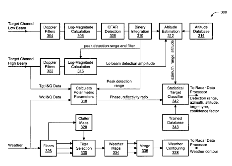
FIG. 3 shows further details 300 of the system 200 of FIG. 2. For the low beam
target channel,
data is processed by a series of modules including a Doppler filter module
304, and log-magnitude
calculation module 306. A CFAR (Constant False Alarm Rate) detection module
308 is coupled to a
binary integration module 310, which provides an output to an altitude
estimation module 312. The
altitude estimation module 312 and altitude database 314 are described more
fully below.
Binary integration data (peak detection range and filter) is provided to a log-
magnitude
calculation module 316 for the high beam target channel and to a module to
calculate polarimetric
parameters 318. The high beam target channel path includes a Doppler filter
module 322, which is
coupled to the log magnitude calculation module 316.
The low beam weather channel data is processed by a pulse compression module
and a filter
module 326. A clutter map module 328, a filter selection module 330, and a
clear day coefficient selection
module 332 are coupled in parallel and exchange information with the filter
module 326. A weather map
module 334 receives the filtered data and provides a series of outputs to a
merge module 336, which
provides output data to a weather contour module 338 coupled to a radar data
processor.
The module 318 to calculate polarimetric parameters receives target I and Q
data from the high
beam target pulse compression module and weather I and Q data from the weather
channel pulse
compression module and generates phase and reflectivity ratio information, as
described more fully
below. This information is provided to a statistical target classifier module
342, which receives data from
a trained database 343, outputting detection range, azimuth, altitude, target
type, and confidence
information provided to an RDP.
As shown in FIGs. 4A and 4B, the high beam data and low beam data pair are
extracted along
with the Mode-C code. An amplitude ratio for the high and low beam data is
calculated for a target range
to generate an amplitude ratio table at the altitude given by the Mode-C code,
as shown. In one
embodiment, a 3x32 cells operator (32
8
CA 02723682 2010-11-05
WO 2009/137441 PCT/US2009/042789
range columns and 3 altitude rows) is used to average the amplitude ratio. The
table is
then smoothed before being used for altitude estimation. FIG. 4B shows the
smoothed amplitude ratio versus altitude curve for the range of 30 nmi.
FIG. 5 shows an exemplary sequence of steps for estimating altitude in
accordance with exemplary embodiments of the invention. In step 500, the
amplitude
ratio is determined for a given range from the high beam signal over the low
beam
signal. In step 502, it is determined whether the amplitude ratio is less than
a low
threshold value. If so, no estimation is performed in step 504. If not, then
it is
determined in step 506 whether the amplitude ratio is greater than a high
threshold. If
so, no altitude estimation is performed. If not, in step 508, the amplitude
ratio is
rounded to an index value. In step 510, an altitude estimation and confidence
value
are generated from a table, such as the table of FIG. 4A, from the range and
index
values.
In an exemplary embodiment, the target altitude is estimated at 100 foot
intervals with a confidence factor ranging from 0 to 1. The confidence factor
can be
pre-calculated in the table based on the standard deviation of the altitude
value at the
given amplitude ratio before smoothing was applied, for example. It is
understood that
the granularity of the altitude estimate can vary to meet the needs of a
particular
application and the information obtainable from the radar system.
FIG. 5A shows an exemplary plot of amplitude ratio versus altitude at various
ranges, shown as 10, 20, 30, 40, and 50 nautical miles (nmi) for exemplary
data. It is
understood that the plotted data is smoothed. The approximate threshold
values, AH
and AL, are also shown in FIG. 5A marking the linear portion of the smoothed
data.
FIG. 6 shows an exemplary sequence of steps for polarimetric parameter
calculation in accordance with exemplary embodiments of the invention. For
given
range, lc, Qc, co-polarization data, and Ir, Qr reverse polarization data, in
step 600 I
and Q data is selected from the specified range R. In step 602, the
differential
/12 /12 +Q2 \
reflectivity ZDR is computed as ZDR = 101og10 c \cc 101og10 '
9
CA 02723682 2010-11-05
WO 2009/137441 PCT/US2009/042789
In step 604, the differential phase ODl is computed as
( / r
I
D/? = tan _________ tan ¨
FIG. 7 shows an exemplary sequence of steps for statistical target
classification. In step 700, for given range R, estimated altitude Alt,
differential
reflectivity ZDR, and differential phase DR, integer values ir, ja, iz, and
id, are
generated in step 702 to generate probability values. More particularly, a
probability
of the target being an aircraft Ptot is computed from a table using values
tgt,
-r, -a, -z, -d=
In an exemplary embodiment, the indexes tgt, wx, bird and cltr represent four
separate
tables that form the trained database filled with measured data from known
objects
such as aircraft (tgt), weather (wx), birds (bird) and ground clutter (cltr).
Similarly, a
probability of a target being a weather-related false alarm is determined from
a table
based on values for wx, it, ja, iz, id. The probability of a target being
birds is
determined from bird,r, ii a, iz, id and the probability of a target being
ground clutter
- - -
related false alarm is deteinfined from cltr,
-r, -a, -z, -d=
In another embodiment, the amplitude ratio (ZDR) and phase difference (DR)
between the target and weather channel data can be calculated to distinguish
target
characteristics. As noted above, a DASR system, such as the system 100 of FIG.
1,
has a target and a weather channel. The weather channel is a different
polarization to
the target channel, and they are processed in separate receiver-signal
processor
channels.
The DASR weather channel determines precipitation reflectivity. In an
exemplary embodiment, the weather channel data is processed in a similar
manner to
the target channel data. This approach provides simultaneous polarimetric
data, which
is an improvement over polarimetric data in alternative radar dwells. The
amplitude
ratio (ZDR) and phase difference (DR) between the target and weather channel
data can
be calculated as follows:
2 2 \
+ Q
ZDR 10.1og10
L
(1)
m
T n2
CA 02723682 2010-11-05
WO 2009/137441 PCT/US2009/042789
( /
= tan-1 ic tan-1
ODR (2)
Qrì
where R is range, /, and Q, are the in-phase and quadrature data of the co-
polarization
channel, and I, and Q, are the in-phase and quadrature data of the reverse
polarization
channel.
It should be noted that while some systems, such as current ASR systems use a
dual fan beam, they do not provide target altitude without associated beacon
data.
Since a DASR has both high and low beams, these beams can be processed
simultaneously in a similar manner as in a mono-pulse radar to estimate target
altitude.
o FIG. 3 described above shows an exemplary system having illustrative
processing
modules.
Actual data was recorded for simultaneous polarimetric data. FIG. 8 shows an
example of estimated target altitude in comparison with the target altitude
from the
i 5 beacon radar. The altitude estimations (dots) have deviation from the
beacon radar
reported altitude (Mode C ode). Smoothing the altitude estimations over 13
scans, for
example, provides a more accurate estimation of the target altitude. In this
case the
RMS error is 240 ft.
20 FIG 9 shows the distinct features of an aircraft and FIG. 10 shows
possible
bird data expressed in amplitude ratio versus phase difference maps based upon
collected data. FIG. 9 shows the peak of the distribution at 0 degree phase
difference
and 6 dB amplitude ratio. The bird data in FIG. 10 has a peak of the
distribution at 30
degrees phase difference and 9 dB amplitude ratio. It should be noted that the
25 distribution in FIG. 10 has wider spread than FIG. 9.
Exemplary embodiments of the invention use amplitude ratio, phase
difference, estimated target altitude and target velocity, for target
classification to
distinguish aircraft from birds and precipitation. In illustrative embodiment,
radar
30 systems can include inventive target classification.
11
- CA 02723682 2013-03-25
It is understood that a variety of polarizations can be used in various
embodiments. Exemplary
polarizations include linear polarization (transmission in vertical
polarization, channel A received in
elliptical polarization, channel B received in vertical polarization),
circular polarization (transmission in
circular polarization, channel A received in circular co-polarization, and
channel B received in circular
reverse polarization). As noted above, circular polarimetric data shows clear
differences between channels
and target types. It is understood that further polarization configurations
are possible.
Having described exemplary embodiments of the invention, it will now become
apparent to one
of ordinary skill in the art that other embodiments incorporating their
concepts may also be used. The
embodiments contained herein should not be limited to disclosed embodiments
but rather should be
limited only by the scope of the appended claims.
What is claimed is:
12