Note: Descriptions are shown in the official language in which they were submitted.
CA 02724113 2010-11-10
WO 2009/148705 PCT/US2009/040535
VIRTUAL PETROLEUM SYSTEM
BACKGROUND
1. Field of the Invention
[0001] The present invention relates generally to processing of geological
data and more particularly to a system for three-dimensional analysis and
visualization.
Description of the Related Art
[0002] Analysis and visualization of data relating to oil and gas exploration
generally involve custom software tools that have specific, narrow
functionality,
Much of the analysis of data still requires human interpretation of ambiguous
information. When the operator makes a decision on the proper interpretation
of
image data, that information is generally restricted to the particular
interpretive
tool on which the operator is currently working and does not propagate to
other
software toads. Likewise, sharing between physical locations may be difficult,
which can raise issues where experts from various disciplines are not co-
located,
but have a need for cooperation.
SUMMARY
[0003] Aspects of embodiments of the present invention provide a system
for processing and display of earth data including an input module configured
to
accept a plurality of types of data indicative of a plurality of
characteristics of a
geological region, a plurality of modeling modules, each modeling module
configured to model physical, geophysical and/or geological properties of the
geological region based on at least a portion of the data, an interface
module,
operable by a user to input parameters and to select relevant portions of the
input data for use by the modeling modules, a data management module,
configured to receive data from the input module and to provide data to the
modeling modules, wherein, for a change in data received by the input nodule
or
_tr
CA 02724113 2010-11-10
WO 2009/148705 PCT/US2009/040535
a change in parameters received by the interface module, the data management
module passes changed data to the modeling modules for re-processing in
accordance with the changed data or parameters, and a display module,
configured and arranged to create graphical displays based on the modeled
properties of the geological region and to update the graphical displays in
accordance with the re-processing.
[0004] Aspects of embodiments of the invention may include a method for
processing and display of earth data including accepting a plurality of types
of
data indicative of a plurality of characteristics of a geological region,
modeling
physical, geophysical and/or geological properties of the geological region
based
on at least a portion of the data, receiving data from a user-operable input
module modifying portions of the data for use by the modeling modules,
providing modified data to the modeling modules, for re-processing in
accordance with the modified data, displaying images representing the data
based on the modeled properties of the geological region, and updating the
graphical displays in accordance with the re-processing,
[0005] Aspects of embodiments of the invention may include a system for
three dimensional modeling of earth data including a data storage system,
configured and arranged to torn data relating to a plurality of
characteristics of a
geological region, a modeling module, configured and arranged to process the
stored data and to produce modeled attributes of at least a portion of the
geological region, a three dimensional display module, configured and arrange
to
produce, based on the modeled attributes, a three dimensional representation
of
at least a portion of the geological region, the three dimensional display
module
further being configured to apply geological constraints to the modeled
attributes
such that unrealisticgeologK;al visualizations are excluded when producing the
three dimensional representation.
[0006] Aspects of embodiments of the invention may include a computer-
readable medium encoded with computer-executable instructions for performing
the foregoing method or for controlling the foregoing system.
-2
CA 02724113 2010-11-10
WO 2009/148705 PCT/US2009/040535
[0007] Aspects of embodiments of the invention may include a system
incorporating the foregoing system and configured and arranged to provide
control of the system in accordance with the foregoing method. Such a system
may incorporate, for example, a computer programmed to allow a user to control
the device in accordance with the method, or other methods.
[0008] These and other objects, features, and characteristics of the
present invention, as well as the methods of operation and functions of the
related elements of structure and the combination of parts and economies of
manufacture, will become more apparent upon consideration of the following
description and the appended claims with reference to the accompanying
drawings, all of which form a part of this specification, wherein like
reference
numerals designate corresponding parts in the various F G ;. It is to be
expressly understood, however, that the drawings are for the purpose of
illustration and description only and are not intended as a definition of the
limits
of the invention. As used in the specification and in the claims, the singular
form
of "a", "an", and "the" include plural referents unless the context clearly
dictates
otherwise.
CA 02724113 2010-11-10
WO 2009/148705 PCT/US2009/040535
BRIEF DESCRIPTION OF THE DRAWINGS
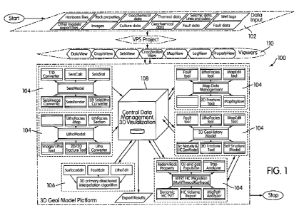
[0009] FIG, 1 is a schematic diagram of an architecture of a system in
accordance with an embodiment of the present invention;
[0010] FIG. 2A-2E are illustrations of an embodiment of integrated
visualization functionality;
[0011] FIG, 3 is an illustration of a pseudo-3D visualization in accordance
with an embodiment of the present invention;
[0012] FIG. 4 is an illustration of a pseudo-3D visualization in accordance
with an embodiment of the present invention;
[0013] FIG. 5A-C are illustrations of an embodiment of salt restoration
functionality;
[0014] FIG. 6A-B are illustrations of an embodiment of litho-facies
interpretation functionality; and
[0016] FIG, 7 is a schematic illustration of an embodiment of a system for
performing methods in accordance with embodiments of the present invention.
DETAILED DESCRIPTION
[0016] A virtual petroleum system in accordance with an embodiment of
the present invention includes a number of software modules that are
interconnected for efficient sharing and processing of data. As illustrated
schematically in FIG. 1, the system 100 includes an input module 102, that is
configured to accept relevant data, which may include multiple types of data
(e.g,, seismic data, well logs, and the like). The data is indicative of one
or more
characteristics of a geological region under investigation.
[0017] In an example, the input module 102 may be configured to accept
data including horizons files, rock properties, geochemical data, thermal
data,
seismic data (which may be, for example, raw seismic data, 2-d lines, and//or
3-d
cubes), well logs, images, culture data (i.e,= political boundaries,
geographic
places, land ownership, information regarding human constructed structures
-4-
CA 02724113 2010-11-10
WO 2009/148705 PCT/US2009/040535
including roads, buildings, oil platforms and the like and/or environmental
features) and fault data.
[0018] These data types are, in general, from a variety of sources and as
a result are stored in different formats and have different data structures
but as a
rule they can be stored on common storage media such as a disc drive or array
of drives. The stored data may be local to the rest of the system, or may be
remotely accessible through a LAN, WAN, or via the Internet or other network,
for example.
(00191 Modeling modules 104, which are configured to model physical,
geophysical and/or geological properties of the geological region based on the
data, accept a portion or all of the data as an input, and process it to
produce
models that provide the user with some insight as to the nature of the
geological
region. The modeling modules may include, for example, lithographic modeling,
seismic modeling, map data management, geological history modeling, and
hydrocarbon migration modeling. As will be appreciated, there are a variety of
modeling techniques that can be used, and the specific modeling
functionalities
can be s jec tad in accordance with appropriate design considerations.
[0020] An interface module 106 is operable by a user to input parameters
and to select relevant portions of the input data for use by the modeling
modules.
For example, the interface may include a graphical user interface. For
example,
it may include functionality allowing a user to select areas where. a fault
line
appears to exist. Likewise, the user may assign particular lithological labels
to
portions of the data in accordance with his expert interpretation of, for
example,
well log data. In an embodiment, a functionality for horizon picking within a
3-d
visualization may be included,
[0021] The interface module 106 may also include functionality for
controlling data management. As an example, the interface module may include
functionality for combining types of data, for selecting types or sources of
data to
be displayed, or for modifying visualizations of data.
[0022] A central data management module 108 interacts with the
modeling modules 104 and the interface module 106. As changes to parameters
-5-
CA 02724113 2010-11-10
WO 2009/148705 PCT/US2009/040535
or information relating to expert interpretation of the data are made by the
user,
those changes are propagated to the other modeling modules via the data
management module. Returning to the fault line example, when a fault line is
added to a visualization or modified using the interface module 106, that
information is passed to the central data management module 108. The central
data management module 108 then passes the fault locations to the various
à odeling modules 104, which incorporate the fault information into their
modules. Thus, as the modeling modules receive the new information, the data
are re-processed in accordance with the changed data or parameters. In an
embodiment, such changes are reprocessed in real time.
[0023] Continuing with the fault example, fault information may be passed
to a module that models hydrocarbon migration, The fault would be incorporated
into the model and could be treated as a trap or a conduit for hydrocarbon
migration, altering the model's expected location of hydrocarbon reservoirs.
If
the models are configured to process the new data in two dimensions, then the
modeling calculations may be processed relatively faster than if three
dimensional calculations are required.
[0024] A number of display modules or viewers 110, which may
themselves either incorporate or be incorporated by portions of the interface
module, allow for various data views. For the purposes of this disclosure, the
terms viewer, visualization module and/or display module are used
interchangeably to refer to viewers 110, In this regard, the modeling modules
104 pass information regarding modeled properties of the region to a display
module that renders graphical displays based thereon. As a memory
management solution, the central data management module may be
programmed to push data to the viewer modules for display and then to ensure
that calculations necessary to produce the image data that is being displayed
are
removed from active memory.
[0025] Figure 2A shows 3-D basin modeling data 200, 202, 204, which
may represent, for example, basin models from three different sources. Another
view module may render an overhead; or map, view. As illustrated in Figure
213,
CA 02724113 2010-11-10
WO 2009/148705 PCT/US2009/040535
a map 206 of a reservoir area 208 may include an overlay of block boundaries
208, indications of where wells have been drilled 212, onto which basin
modeling
data 200 has been copied.
[002] In this embodiment, the system includes a facility for selecting
areas of interest via an interface module 106, and pasting from one view to
another, such that the basin model information may be pasted into the map 206
within a selected area. In Figure 2C, the second region 202 has been pasted
onto map 206', while in 2D, the third region 204 is pasted onto map 206 In
this
manner, the information represented in Figure 2A is superimposed on the map
view of Figure 2B-D, allowing an analyst to view several types of information
concurrently and to integrate the information in conducting analysis of the
basin.
[0027] The interface module may also include functionality for allowing
map editing, painting, polygon fill or the like. An example of such an edited
map
is shown in Figure 2E, where the map 206... is shown as including information
from all three regions 200, 202, 204. As may be seen, the user has indicated,
via line 230 and 232, and via the widely painted region 234, basin topographic
information. The input basin topographic information can be derived from other
data sources, or may be, for example, based on expert interpretation of the
adjacent regions. Additionally a cross section A-A of interest has been
designated. In an embodiment, the designated cross section may be selected
for display in a display module or viewer 11 O.
(0028] In an embodiment, the display module renders the reprocessed
properties in real time, allowing a user to see the effect of changes in the
parameters as those changes are input into the system.
[0029] One method of accelerating this real-time reprocessing is, as briefly
described above, conducting all, or most, modeling in two dimensions. The two
dimensional models can then be used to create two dimensional images. By
displaying the two dimensional images in a pseudo three dimensional space, the
appearance of three dimensional information can be conveyed.
[0030] Furthermore, even three dimensional information may be included
and displayed in relation to the two dimensional information. In this regard,
-7-
CA 02724113 2010-11-10
WO 2009/148705 PCT/US2009/040535
display and modeling can be accelerated by restricting three dimensional
information to two dimensional representations.
[0031] As illustrated in Figure 3, a number of two dimensional seismic
lines 300 are arranged in accordance with their three dimensional relative
orientations and positions. Furthermore, this display includes some three
dimensional information in the form of one horizon 302 of a three dimensional
basin model. By restricting the three dimensional information to a relatively
thin
slice, it can be treated as two dimensional and can be evaluated and updated
relatively rapidly,
[0032] In an embodiment, visibility of information of interest can be
improved by providing a cutaway view. As seen in Figure 3, a number of the
seismic lines 300' are shown with a reduced height as thin stripes. If every
seismic line were to be shown in full height, the ones in the foreground would
block a view of the ones in the background. Alternately, the interface may
allow
for a user to rotate the visual display in order to reveal previously obscured
portions of the display.
[0033] Also shown in Figure 3 are two crossing two dimensional images
310, 312. These two images represent geological information that may be, for
example, determined by combining information from the seismic imaging with
lithological and geological information from other modeling modules, As will
be
appreciated, portions of this information may be derived from expert
interpretation and the results of that interpretation may be input using the
interface module 100.
[0034] The interface module may further include functionality for selecting
a horizon of interest within the displayed data. Once selected, various
operations are possible, including for example flattening the selected
horizon.
As illustrated in Figure 4, the horizon 400 has been flattened, with the
effect of
changing the vertical positions of other horizons, resulting in the raised
portion
402 and the corresponding lifting of the bottom horizons at 404. Other
displayed
objects (such as seismic 2D lines) can likewise be correspondingly adjusted
relative to the reference surface or the flattened horizon. As will be
appreciated,
-8-
CA 02724113 2010-11-10
WO 2009/148705 PCT/US2009/040535
such selective flattening can be used for a number of purposes, including, for
example, inspection for the existence of crossover between stratigraphic
units.
Where such a crossover is noted, a user may enter a correction using the
interface module and the correction will be propagated via the central data
management module back to each of the modeling modules
[0035] In an embodiment, salt history modeling may be included as one of
the modeling modules 104. In this embodiment, a region containing a salt
formation that overlies a sediment region is modeled by defining an initial
geometry of a salt volume and sediment volume in three dimensions. Time-wise
steps are taken, and at each step, a geometry of the salt top is changed while
the sediment top and the salt volume are maintained as constants.
[0036] During the modeling, other models' results are included as inputs to
the salt volume modeling. For example, as other models indicate faulting or
other geological activity such as folding or deformation, those changes are
incorporated into the salt model. As will be appreciated, where those
activities
impact the shape of the salt base, the initial assumption that the salt base
has a
constant geometry is incorrect, As a result, salt base geometry is updated in
accordance with the changes to the adjoining formations.
[0037] Additionally, functionality may be included for modeling dissolved
salt (i.e., removed salt) and deposited salt, depending on the exposure of the
salt
volume to an environment where dissolution can take place.
[0038] In an iterative process, a user may control the salt history
progression. In particular, the user may guide the aforementioned integration
of
data from fault and other models, Likewise, a user may provide guidance for
modeling of complex sub salt structures and salt reentry issues.
[0039] As an output, a series of three dimensional images can be
generated that each represent one of the time-wise steps. Furthermore, the
time-wise steps may be used as time varying inputs to other models that
include
time components. For example, where a hydrocarbon migration model is
included, flow parameters can be adjusted through time as the salt model
changes.
-9-
CA 02724113 2010-11-10
WO 2009/148705 PCT/US2009/040535
[0040] As illustrated in Figures 5A-C, a salt bottom 500 forms a bottom
layer of the salt formation 502 shown in the form of two cross-sectional
areas.
Figure B represents a time step from the initial formation as shown in Figure
5A. Additional sediment layers 504 overlie the salt formation 502 while the
base
500 has remained substantially constant. The salt top is significantly
changed,
however a total volume of salt is maintained. Figure C represents a last time
interval i the progression and would in practice represent the present-day
state
of the salt basin as measured, for example, by seismic imaging.
[0041] In an embodiment, functionality may be included for interpolation of
lithographic facies by a probabilistic approach. In this approach, a
particular
interval is selected for i<eterp :lation and a top and bottom facies are
defined for
the interval. The source may be, for example, a seismic cross section or other
seismic data including seismic images, seismic maps, seismic stratal slices or
the like.
[0042] A user selects a lithological interpretation for the top and bottom
facies, for example by brush drawing, polygon filling or other typical
conversion
methods, such as correlation between lithologic facies vs. seismic attributes,
sediment thickness, paleo-bathymetry and the like. Then, the interval is
divided
into a number of thin layers for interpolation by a stochastic method.
[0043] In the stochastic interpolation approach, the thin layers are each
assigned a lithology group based on the top and bottom layers, with a random
variation introduced. A gradient between the composition of the top layer and
that of the bottom layer may be applied so that as the layers get closer to
one or
the other, they likewise become closer in composition. As an example, the
distance of a given layer can be used to generate weightings for the
composition
of that layer relative to the top and bottom layers. Then, a random component
is
applied and constrained, for example, by a normal distribution,
[0044] For each layer, the sum of the components is determined by the
top and base litho-facies, but the lateral distribution of the components
along any
given portion of the layer is rearranged by applying a normal distribution
function
to them. Optionally, a number of iterations of applying the normal
distribution
CA 02724113 2010-11-10
WO 2009/148705 PCT/US2009/040535
function may be performed. The number of iterations may be determined, for
example, by checking the litho-facies against seismic attributes or well logs.
If
necessary, manual adjustments may be made. Likewise, shifts may be
introduced, so that the interval more closely matches a realistic composition.
Finally, information from other data sources, such as seismic lines that
cross, the
same region, can be used to modify the interpolated results for portions of
the
layer that intersect such data.
[004$] Figure 6A illustrates a three dimensional view of a lithographic
model in accordance with the foregoing embodiment. As can be seen, in
addition to the fades information, indicated generally at 600, this view may
include integrated information from other sources. As illustrated, a number of
wells 602 and their respective well logs 604 can be overlaid on the litho
fades
information. The random variation due to the stochastic process can be seen as
the varying shaded rectangular areas best visible in the top layer.
[0046] Figure 63 illustrates a single horizon 610 instead of the three
dimensional view of Figure 6A. The horizon is crossed by two cross-sections
612, 614 in which randomly varying layers are visible.
[0047] In an embodiment, one of the modeling modules may be directed
to hydrocarbon migration modeling. As will be appreciated, a migration module
may use as input information from any of the other data sources that relates
to
hydrocarbon migration. As examples, information regarding permeability (such
as may be derived from well logging, lithology, and the like), faults, which
may
act as pathways or seals, salt formation and history, and deposition history
may
all form inputs to the migration model.
[0048] In particular, the model may take as an input a high-resolution
model such as a permeability and saturation based flow model. The model may
include both oil and gas migration and entrapment.
[0049] In the embodiment, rather than a step-wise movement through time
for the entire basin, each source point is treated independently. For a random
source point, the migration progresses through time along a path that seeks to
maximize the reduction of potential, i.e., a minimum energy path, wherein
- 11 -
CA 02724113 2010-11-10
WO 2009/148705 PCT/US2009/040535
resistance to flow is opposed by buoyancy. Where a time varying geology is
known (or modeled), for example where a salt history or depositional history
is
known, the time variation is included in the flow model under which the
reduction
of potential is evaluated.
[0050] Because all sources are evaluated independently, they are
considered as having no interaction with other sources until they reach a
trap.
For each source, calculation is stopped upon arrival at a trap. Because a trap
may have a maximum fill volume, the independent treatment must be suspended
at traps where evaluation for spill is performed. If a total volume of
hydrocarbon
arriving at a particular trap exceeds the volume capacity, then the extraneous
portion can be further migrated using the model.
[0051] A system 700 for performing the method is schematically illustrated
in Fig. 7, A system includes a data storage device or memory 702. The stored
data may he made available to a processor 704, such as a programmable
general purpose computer. The processor 704 may include interface
components such as a display 706 and a graphical user interface 708. The
graphical user interface may be used both to display data and processed data
products and to allow the user to select among options for implementing
aspects
of the method. Data maybe transferred to the system 700 via a bus 710 either
directly from a data acquisition device, or from an intermediate storage or
processing facility (not shown).
[0052] As will be appreciated, the individual data sources, modeling
modules and view modules may be typical software programs in accordance with
usual practice. The central data management module is designed in accordance
with the input and output requirements of these modules. In an embodiment, the
various modules are implemented in an object oriented programming language
in which properties are defined in accordance with specified classes. When one
of the modules initiates a change to a particular item of data, either in
response
to a user input or as a result of a modeling calculation, the change is
returned to
the central data management module which then propagates the change to the
12-
CA 02724113 2010-11-10
WO 2009/148705 PCT/US2009/040535
data in the same class as the changed data, thereby ensuring that all modules
are synchronize,
[0053] Although the invention has been described in detail for the purpose
of illustration based on what is currently considered to be the most practical
and
preferred embodiments, it is to be understood that such detail is solely for
that
purpose and that the invention is not limited to the disclosed embodiments,
but,
on the contrary, is intended to cover modifications and equivalent
arrangements
that are within the spirit and scope of the appended claims. For example,
though
reference is made herein to a computer, this may include a general purpose
computer, a purpose-built computer, an A SIC programmed to execute the
methods, a computer array or network, or other appropriate computing device.
As a further example, it is to be understood that the present invention
ntmplates that, to the extent possible, one or more features of any
embodiment can be combined with one or more features of any other
embodiment.
-13-