Note: Descriptions are shown in the official language in which they were submitted.
CA 02725347 2010-12-14
13497P0059CAOl
SYSTEM FOR ADJUSTING GEOPHYSICAL SENSOR STREAMER
FRONT END TOWING DEPTH
Background of the Invention
Field of the Invention
The invention relates generally to the field of marine geophysical surveying
using
towed streamers. More specifically, the invention relates to devices for
controlling the
towing depth of forward end of a geophysical sensor streamer.
Background Art
Marine geophysical surveying includes seismic surveying systems. Seismic
survey
systems are used to acquire seismic data from Earth formations below the
bottom of a body
of water, such as a lake or the ocean. Marine seismic surveying systems
typically include a
seismic vessel having onboard navigation, seismic energy source control, and
data recording
equipment. The seismic vessel is typically configured to tow one or more
streamers through
the water. At selected times, the seismic energy source control equipment
causes one or
more seismic energy sources (which may be towed in the water by the seismic
vessel or by
another vessel) to actuate. Signals produced by various sensors on the one or
more streamers
are ultimately conducted to the recording equipment, where a record with
respect to time is
made of the signals produced by each sensor (or groups of such sensors). The
recorded
signals are later interpreted to infer the structure and composition of the
Earth formations
below the bottom of the body of water.
The one or more streamers are in the most general sense long cables that have
seismic
sensors disposed at spaced apart positions along the length of the cables. A
typical streamer
can extend behind the seismic vessel for several kilometers. Because of the
great length of
the typical streamer, the streamer may not travel entirely in a straight line
behind the seismic
vessel at every point along its length due to interaction of the streamer with
the water and
currents in the water, among other factors.
More recently, marine seismic acquisition systems have been designed that
include a
plurality of such streamers towed by the seismic vessel in parallel. The
streamers are towed
by the vessel using towing devices, and associated equipment that maintain the
streamers at
CA 02725347 2010-12-14
selected lateral distances from each other as they are towed through the
water. Such multiple
streamer systems are used in what are known as three dimensional and four
dimensional
seismic surveys. A four dimensional seismic survey is a three dimensional
survey over a
same area of the Earth's subsurface repeated at selected times. The individual
streamers in
such systems are affected by the same forces that affect a single streamer.
The quality of images of the Earth's subsurface produced from three
dimensional
seismic surveys is affected by how well the positions of the individual
sensors on the
streamers are controlled. The quality of images generated from the seismic
signals also
depends to an extent on the relative positions of the seismic receivers being
maintained
throughout the seismic survey. Various devices are known in the art for
positioning
streamers laterally and/or at a selected depth below the water surface. U.S.
Patent No.
5,443,027 issued to Owsley et al.. for example, describes a lateral force
device for displacing
a towed underwater acoustic cable that provides displacement in the horizontal
and vertical
directions. The device has a hollow spool and a rotationally mounted winged
fuselage. The
hollow spool is mounted on a cable with cable elements passing therethrough.
The winged
fuselage is made with the top half relatively positively buoyant and the
bottom half relatively
negatively buoyant. The winged fuselage is mounted about the hollow spool with
clearance
to allow rotation of the winged fuselage. The difference in buoyancy between
the upper and
lower fuselage maintains the device in the correct operating position. Wings
on the fuselage
are angled to provide lift in the desired direction as the winged fuselage is
towed through the
water. The device disclosed in the Owsley et al. patent provides no active
control of direction
or depth of the streamer. however.
U.S. Patent No. 6.011,752 issued to Ambs et al. describes a seismic streamer
position
control module having a body with a first end and a second end and a bore
therethrough from
the first end to the second end for receiving a seismic streamer. The module
has at least one
control surface, and at least one recess in which is initially disposed the at
least one control
surface. The at least one control surface is movably connected to the body for
movement
from and into the at least one recess and for movement, when extended from the
body, for
attitude adjustment. Generally, the device described in the Ambs et al. patent
is somewhat
larger diameter, even when closed, than the streamer to which it is affixed,
and such diameter
may become an issue when deploying and retrieving streamers from the water.
2
CA 02725347 2015-12-14
U.S. Patent No. 6,144,342 issued to Bertheas et al. describes a method for
controlling the
navigation of a towed seismic streamer using "birds" affixable to the exterior
of the streamer. The
birds are equipped with variable-incidence wings and are rotatably fixed onto
the streamer.
Through a differential action, the wings allow the birds to be turned about
the longitudinal axis of
the streamer so that a hydrodynamic force oriented in any given direction
about the longitudinal
axis of the streamer is obtained. Power and control signals are transmitted
between the streamer
and the bird by rotary transformers. The bird is fixed to the streamer by a
bore closed by a cover.
The bird can be detached automatically as the streamer is raised so that the
streamer can be wound
freely onto a drum. The disclosed method purportedly allows the full control
of the deformation,
immersion and heading of the streamer.
It is also important to control the depth of the streamers in the water so
that effects of
seismic signal reflection from the water-air interface can be controlled.
There exists a need for
devices to control the depth of the forward end of a streamer in a streamer
array in the water.
While the explanation of the need for the invention is generally explained in
terms of
seismic surveying, it is important to recognize that the invention is
applicable to any survey system
which includes a plurality of laterally spaced apart sensor streamers towed by
a vessel. Such other
types of streamers may include, without limitation, electrodes, magnetometers
and temperature
sensors. Accordingly, the invention is not limited in scope to seismic
streamers.
Summary of the Invention
In accordance with one aspect of the present invention, there is provided a
system for
towing marine geophysical sensor streamers, comprising: a plurality of lead in
lines extending
from a tow vessel, wherein for each lead in line there is: a streamer front
end termination
coupled to an aft end of the lead in line; a sensor streamer coupled at a
forward end thereof to
the front end termination, the sensor streamer including a plurality of
geophysical sensors
disposed at spaced apart locations along its length; a floatation device
coupled by .a line
extending therefrom to proximate the forward end of the sensor streamer; a
winch disposed on
the floatation device to extend and retract the line; a depth sensor, disposed
proximate the
forward end of the sensor streamer; and a controller in signal communication
with the winch
and the depth sensor so that the forward end of the sensor streamer is
maintained at a selected
depth in the body of water; and a depressor coupled proximate a forward end of
laterally
outwardmost ones of the sensor streamers.
3
CA 02725347 2015-12-14
In accordance with another aspect of the present invention, there is provided
a
method for towing sensor streamers in a body of water, comprising: extending
each of a
plurality of lead in lines from a tow vessel moving in the body of water to
laterally spaced
apart respective front end terminations, the front end terminations each
coupled to a
forward end of a respective sensor streamer disposed in the body of water,
each sensor
streamer including a plurality of geophysical sensors disposed at spaced apart
locations
along its length; suspending each of the sensor streamers from a point
proximate their
forward ends from a floatation device near the surface of the body of water;
adjusting the
length of a line extending between each suspension point and each floatation
device so that
each suspension point is maintained at a selected depth in the body of water;
and applying
a downward force proximate the suspension point of laterally outwardmost ones
of the
sensor streamers.
A system for towing a marine geophysical sensor streamer according to one
aspect
of the invention includes a lead in line extending from a tow vessel. A
streamer front end
termination is coupled to an end of the lead in line and to a forward end of
the sensor
streamer. A floatation device is coupled by a line proximate to the front end
termination. A
winch is disposed on the floatation device to extend and retract the line. A
depth sensor is
disposed proximate the front end termination. A controller is in signal
communication with
the winch and the depth sensor so that the forward end of the streamer is
maintained at a
selected depth in the body of water.
3a
CA 02725347 2010-12-14
In some examples, a depressor is coupled proximate to the front end
termination. The
depressor applies downward force proximate to the front end termination in a
body of water.
A method for towing a marine sensor streamer in a body of water according to
another aspect of the invention includes extending a lead in line from a tow
vessel moving in
a body of water to a front end termination. The front end termination is
coupled to a forward
end of a sensor streamer disposed in the water. The streamer is suspended
proximate its
front end from a floatation device near the surface of the water. A length of
a line extending
between the floatation device and the suspension point is changed so that the
front end of the
streamer is maintained at a selected depth in the water.
In some examples, a downward force is applied proximate to the front end
termination.
Other aspects and advantages of the invention will be apparent from the
following
description and the appended claims.
Brief Description of the Drawings
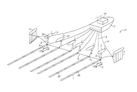
FIG. 1 is an oblique view of a sensor streamer system using streamer front end
depth
control devices according to the invention.
FIG. 2 shows one of the combination floatation device and winch units of FIG.
1 in
more detail.
Detailed Description
A geophysical sensor streamer array towed by a survey vessel is shown in
oblique
view in FIG. I. The vessel 7 moves along the surface of a body of water 11.
The vessel 7
includes thereon survey acquisition equipment, shown generally at 14 and
referred to for
convenience as a "recording system- 14. The recording system 14 includes (none
shown
separately) devices for determining geodetic position of the vessel 7, devices
for recording
signals generated by each of a plurality of geophysical sensors 20, devices
for actuating a
geophysical energy source (not shown in FIG. I) if such source is used, and in
some
examples, devices for controlling deployment of one or more streamer front end
winches 10,
each deployed in a respective floatation device 3.
4
CA 02725347 2010-12-14
The vessel 7 may tow one or more sensor streamers I. The streamers 1 may each
be
coupled to a lead in cable 5, which transfers motion of the vessel 7 to the
forward end of each
steamer 1 through a front end termination 15. If a plurality of streamers 1 is
used, as shown
in FIG. 1, typically the streamers 1 will be towed at laterally spaced apart
positions behind the
survey vessel 7. Lateral separation may be obtained by deploying a deflector
or -paravane- 2
at the end of each of two paravane ropes 4 (also known as a -super wide-
rope). The
paravanes 2 generate force transversely outward from the direction of motion
of the vessel 7,
and apply such lateral force to spreader cables 8 connected thereto and
between the streamer
front end termination 15. As shown in FIG. 1, which is one possible
configuration, there is
no spreader cable 8 between the two centremost streamer front end connections
15.
The streamers 1 each have a plurality of geophysical sensors 20 deployed along
the
length of the streamer I. In the present example, the geophysical sensors may
be
substantially collocated seismic particle motion sensors and pressure time
gradient sensors
(not shown separately). An example of such sensing devices in a marine
streamer and the
construction thereof are shown in U.S. Patent No. 7,239,577 issued to Tenghamn
et al. and
commonly owned with the present invention. It should be clearly understood
that the
invention is equally applicable with any other type of geophysical sensor that
can be towed in
a body of water and may be required to be maintained at a selected depth in
the body of water
during survey operations. Accordingly, the type of geophysical sensor is not a
limit on the
scope of the present invention.
In the present example, in which the streamers 1 include the above described
collocated pressure and motion responsive sensors, it may be required to
operate the
streamers 1 at a selected depth in the water that is greater than would occur
as a result of the
combination of forces acting on the streamer (e.g., streamer buoyancy, lateral
pull from the
paravanes, towing, water drag, weight of the front end terminations and lead
in cables, etc.).
In the present example, therefore, a depressor 9 may be coupled to each
laterally outermost
streamer 1 proximate each front end termination 15. Other examples may include
a depressor
coupled proximate each front end termination 15 on each streamer I. The
depressor 9 may
be a simple weight to provide negative buoyancy (downward) force, or may be a
device that
generates hydrodynamic lift in a downward direction as a result of motion
through the water
11. If the depressor 9 is a weight, such as a lead or other dense material
weight, the external
shape thereof may be unimportant, although it may be preferable to provide the
weight with a
CA 02725347 2010-12-14
shape selected to reduce frictional force of motion through the water 11. A
hydrodynamic
depressor may include combinations of projections as suggested in FIG. 1 from
the body of
the depressor 9 to cause downward hydrodynamic lift. The direction and amount
of
hydrodynamic lift may be controlled in some examples. Devices that can provide
controllable hydrodynamic lift are described, for example in U.S. Patent No.
7.457,193 issued
to Pramik and commonly owned with the present invention. Other examples are
described in
the references cited in the Background section herein. The purpose for using
the depressor 9
is that the deflectors 2 used to obtain the necessary streamer lateral spread
are typically towed
at or near the water surface, and tend to pull the streamer spreader cables 8
upwardly when
the desired streamer tow depth is deeper than the tow point of the spreader
cables 8 on the
deflector 2. Such arrangement is typical. Thus, application of the depressor 9
proximate the
front end termination 15 of at least the laterally outwardmost streamers 1
will cause the front
end of the respective streamers 1 to move downwardly in the water 11.
In other examples, the geophysical sensors may be of a type that does not
require
towing the streamers 1 at greater depths than would occur as a result of the
above-described
forces acting on the various components of the acquisition system deployed in
the water 11.
In such cases, the depressor 9 may be omitted, and depth proximate the front
end of each
streamer 1 may be maintained using devices explained below.
The streamers 1 may include (not shown in FIG.1 for clarity) a plurality of
longitudinally spaced apart lateral force and depth control devices to
maintain the depth and
lateral position of each streamer at the selected positions. Such devices are
described, for
example, in U.S. Patent No. 6,144,342 issued to Bertheas et al.
In the present invention, each streamer 1 may be coupled proximate the front
end
termination 15 to a respective floatation device 3 that moves along the water
surface
proximate the respective front end termination 15. The coupling may be
performed using a
line or rope 6 coupled to the streamer 1 proximate the front end termination
15 at one end and
the other end to a winch 10 on board the floatation device 3. Operation of the
winch 10 may
controlled by the recording system 14 using a radio link 12 or similar radio
frequency
communication device. Other examples may provide for automatic winch operation
at the
floatation device 3 as will be explained with reference to FIG. 2. Each front
end termination
15 may include a depth sensor 15A (see FIG. 2) associated therewith, such as a
pressure
sensor, also in signal communication with the recording unit 14 or devices in
the floatation
6
CA 02725347 2010-12-14
Unit described below. When it is desired to maintain the streamer front end
terminations 15
at a selected depth in the water 11, the recording system 14 may be programmed
to operate
the winch 10 (or to program a winch controller in the floatation device 3 as
explained with
reference to FIG. 2) in each floatation device 3 in response to signals from
the respective
pressure (depth) sensors 15A (FIG. 2). In other examples, a sensor (not shown)
that measures
rotation of the winch 10 may be used as an indicator of the depth of the front
end of the
streamer 1. The term "depth sensor- as used herein is intended to include the
foregoing two
example sensors and any other sensing element that generates a signal
corresponding to the
depth proximate the front end of the streamer 1 in the water 11 or the length
of the line 6
deployed by each winch 10.
One of the floatation devices 3 with included winch 10 is shown in more detail
in
FIG. 2. The floatation device 3 may include an enclosed chamber 30 filled with
incompressible, low density liquid or foam or other buoyant material to resist
hydrostatic
crushing and to provide buoyant force to the front end the streamer 1. On the
exterior of or in
the chamber 30, or in a selected subchamber therein may be disposed the
following
components of a depth control system for the streamer front end termination
15. A
transceiver 12 is in radio or other signal communication with the recording
system (14 in
FIG. 12). Signals from the transceiver 12 may be communicated to a central
processor 22
such as a microcontroller. The central processor 22 can generate signals to
drive an electric
motor 24. The motor 24 may include suitable components on its output shaft to
rotate the
winch 10 to extend and retract the line 6 that couples the streamer front end
termination 15 to
the floatation device 10. The winch 10 may include a slip ring 26 to enable
electrical and/or
optical signals from the pressure (depth) sensor 15A to be communicated to the
central
processor 22 and ultimately (by the transceiver 12) to the recording unit (14
in FIG. 1). In
other examples, signals from the depth sensor 15A may be communicated over the
lead in
line 6 to the recording system (14 in FIG. 1). Electrical power to operate the
foregoing
components may be stored in or provided by a battery 28. To supplement battery
power
and/or to charge the battery 28, the floatation device 3 may include an
electrical generator 32
that is rotated by a propeller or turbine 34 in response to motion of the
floatation device 3 in
the water during operations.
The depressor 9 is shown in FIG. 2 to illustrate the relative positioning
thereof with
respect to the floatation device 3. The example depressor in FIG. 2 may be one
of the devices
7
CA 02725347 2010-12-14
explained above that generates controllable downward hydrodynamic lift as the
depressor 9 is
moved through the water 11. As explained above with reference to FIG. 1,
signals from the
depth sensor 15A may be communicated to the recording system (14 in FIG. 1).
which
retransmits a signal to the controller 22 to operate the winch 10 to maintain
a selected depth
in the water. Alternatively, the depth may be programmed into the controller
22, and the
depth can be maintained automatically. Changes to the maintained depth may be
communicated to the controller 22 from the recording system 14 as required. A
system
according to the present invention may provide more precise sensor array
geometry than is
possible using prior art array geometry control devices. The system of the
present invention
also has the capability to change the depth of the front end of geophysical
survey streamers
during operations as needed to meet changing survey conditions.
A streamer system according to the various aspects of the invention may enable
more
precise geophysical surveying by maintaining the forward ends of the
streamer(s) at selected
depths in the water.
While the invention has been described with respect to a limited number of
embodiments, those skilled in the art, having benefit of this disclosure, will
appreciate that
other embodiments can be devised which do not depart from the scope of the
invention as
disclosed herein. Accordingly, the scope of the invention should be limited
only by the
attached claims.
8