Note: Descriptions are shown in the official language in which they were submitted.
CA 02725982 2010-11-25
WO 2010/081540 PCT/EP2009/050370
IMPROVEMENTS RELATING TO NAVIGATION APPARATUS USED IN-VEHICLE
Field of the Invention
The present invention relates to the field of navigation devices for in-
vehicle use,
and methods associated therewith. Such devices may, for example, be installed
as
integral vehicle equipment, or may be portable devices configured or
configurable for in-
vehicle use. The invention may be implemented at least partly within a
navigation
device and/or at least partly with other equipment with which the navigation
device
communicates.
Background to the Invention
Portable navigation devices (PNDs) that include GPS (Global Positioning
System) signal reception and processing functionality are well known and are
widely
employed as in-car or other vehicle navigation systems.
In general terms, a modern PNDs comprises a processor, memory (at least one
of volatile and non-volatile, and commonly both), and map data stored within
said
memory. The processor and memory cooperate to provide an execution environment
in
which a software operating system may be established, and additionally it is
commonplace for one or more additional software programs to be provided to
enable the
functionality of the PND to be controlled, and to provide various other
functions.
Typically these devices further comprise one or more input interfaces that
allow a
user to interact with and control the device, and one or more output
interfaces by means
of which information may be relayed to the user. Illustrative examples of
output
interfaces include a visual display and a speaker for audible output.
Illustrative
examples of input interfaces include one or more physical buttons to control
on/off
operation or other features of the device (which buttons need not necessarily
be on the
device itself but could be on a steering wheel if the device is built into a
vehicle), and a
microphone for detecting user speech. In a particularly preferred arrangement
the
output interface display may be configured as a touch sensitive display (by
means of a
touch sensitive overlay or otherwise) to additionally provide an input
interface by means
of which a user can operate the device by touch.
Devices of this type will also often include one or more physical connector
interfaces by means of which power and optionally data signals can be
transmitted to
and received from the device, and optionally one or more wireless
transmitters/receivers
to allow communication over cellular telecommunications and other signal and
data
networks, for example Wi-Fi, Wi-Max GSM and the like.
CA 02725982 2010-11-25
WO 2010/081540 PCT/EP2009/050370
2
PND devices of this type also include a GPS antenna by means of which
satellite-broadcast signals, including location data, can be received and
subsequently
processed to determine a current location of the device.
The PND device may also include electronic gyroscopes and accelerometers
which produce signals that can be processed to determine the current angular
and linear
acceleration, and in turn, and in conjunction with location information
derived from the
GPS signal, velocity and relative displacement of the device and thus the
vehicle in
which it is mounted. Typically such features are most commonly provided in in-
vehicle
navigation systems, but may also be provided in PND devices if it is expedient
to do so.
The utility of such PNDs is manifested primarily in their ability to determine
a
route between a first location (typically a start or current location) and a
second location
(typically a destination). These locations can be input by a user of the
device, by any of
a wide variety of different methods, for example by postcode, street name and
house
number, previously stored "well known" destinations (such as famous locations,
municipal locations (such as sports grounds or swimming baths) or other points
of
interest), and favourite or recently visited destinations.
Typically, the PND is enabled by software for computing a "best" or "optimum"
route between the start and destination address locations from the map data. A
"best" or
"optimum" route is determined on the basis of predetermined criteria and need
not
necessarily be the fastest or shortest route. The selection of the route along
which to
guide the driver can be very sophisticated, and the selected route may take
into account
existing, predicted and dynamically and/or wirelessly received traffic and
road
information, historical information about road speeds, and the driver's own
preferences
for the factors determining road choice (for example the driver may specify
that the route
should not include motorways or toll roads). The PND may record trip
information so
that the actual journey time may be recorded and fed back for more accurate
prediction
of how journey times vary at different times of day in accordance with
habitual weight of
traffic flow.
In addition, the device may continually monitor road and traffic conditions,
and
offer to or choose to change the route over which the remainder of the journey
is to be
made due to changed conditions. Real time traffic monitoring systems, based on
various
technologies (e.g. mobile phone data exchanges, fixed cameras, GPS fleet
tracking) are
being used to identify traffic delays and to feed the information into
notification systems.
PNDs of this type may typically be mounted on the dashboard or windscreen of a
vehicle, but may also be formed as part of an on-board computer of the vehicle
radio or
indeed as part of the control system of the vehicle itself. The navigation
device may also
CA 02725982 2010-11-25
WO 2010/081540 PCT/EP2009/050370
3
be part of a hand-held system, such as a PDA (Portable Digital Assistant) a
media
player, a mobile phone or the like, and in these cases, the normal
functionality of the
hand-held system is extended by means of the installation of software on the
device to
perform both route calculation and navigation along a calculated route.
Route planning and navigation functionality may also be provided by a desktop
or
mobile computing resource running appropriate software. For example, the Royal
Automobile Club (RAC) provides an on-line route planning and navigation
facility at
http://www.rac.co.uk, which facility allows a user to enter a start point and
a destination
whereupon the server to which the user's PC is connected calculates a route
(aspects of
which may be user specified), generates a map, and generates a set of
exhaustive
navigation instructions for guiding the user from the selected start point to
the selected
destination. The facility also provides for pseudo three-dimensional rendering
of a
calculated route, and route preview functionality which simulates a user
travelling along
the route and thereby provides the user with a preview of the calculated
route.
In the context of a PND, once a route has been calculated, the user interacts
with
the navigation device to select the desired calculated route, optionally from
a list of
proposed routes. Optionally, the user may intervene in, or guide the route
selection
process, for example by specifying that certain routes, roads, locations or
criteria are to
be avoided or are mandatory for a particular journey. The route calculation
aspect of the
PND forms one primary function, and navigation along such a route is another
primary
function.
During navigation along a calculated route, it is usual for such PNDs to
provide
visual and/or audible instructions to guide the user along a chosen route to
the end of
that route, i.e. the desired destination. It is also usual for PNDs to display
map
information on-screen during the navigation, such information regularly being
updated
on-screen so that the map information displayed is representative of the
current location
of the device, and thus of the user or user's vehicle if the device is being
used for in-
vehicle navigation.
An icon displayed on-screen typically denotes the current device location, and
is
centred with the map information of current and surrounding roads in the
vicinity of the
current device location and other map features also being displayed.
Additionally,
navigation information may be displayed, optionally in a status bar above,
below or to
one side of the displayed map information, examples of navigation information
include a
distance to the next deviation from the current road required to be taken by
the user, the
nature of that deviation possibly being represented by a further icon
suggestive of the
particular type of deviation, for example a left or right turn. The navigation
function also
CA 02725982 2010-11-25
WO 2010/081540 PCT/EP2009/050370
4
determines the content, duration and timing of audible instructions by means
of which
the user can be guided along the route. As can be appreciated a simple
instruction such
as "turn left in 100 m" requires significant processing and analysis. As
previously
mentioned, user interaction with the device may be by a touch screen, or
additionally or
alternately by steering column mounted remote control, by voice activation or
by any
other suitable method.
A further important function provided by the device is automatic route re-
calculation in the event that: a user deviates from the previously calculated
route during
navigation (either by accident or intentionally); real-time traffic conditions
dictate that an
alternative route would be more expedient and the device is suitably enabled
to
recognize such conditions automatically, or if a user actively causes the
device to
perform route re-calculation for any reason.
It is also known to allow a route to be calculated with user defined criteria;
for
example, the user may prefer a scenic route to be calculated by the device, or
may wish
to avoid any roads on which traffic congestion is likely, expected or
currently prevailing.
The device software would then calculate various routes and weigh more
favourably
those that include along their route the highest number of points of interest
(known as
POls) tagged as being for example of scenic beauty, or, using stored
information
indicative of prevailing traffic conditions on particular roads, order the
calculated routes
in terms of a level of likely congestion or delay on account thereof. Other
POI-based and
traffic information-based route calculation and navigation criteria are also
possible.
Although the route calculation and navigation functions are fundamental to the
overall utility of PNDs, it is possible to use the device purely for
information display, or
"free-driving", in which only map information relevant to the current device
location is
displayed, and in which no route has been calculated and no navigation is
currently
being performed by the device. Such a mode of operation is often applicable
when the
user already knows the route along which it is desired to travel and does not
require
navigation assistance.
Devices of the type described above, for example the 720T model manufactured
and supplied by TomTom International B.V., provide a reliable means for
enabling users
to navigate from one position to another.
As mentioned above, the memory of the PND stores map data used by the PND
not only to calculate routes and provide necessary navigation instructions to
users, but
also to provide visual information to users through the visual display of the
PND.
As is known in the art, map information can be expressed in a number of ways
and indeed can comprise a number of separate information components, which are
used
CA 02725982 2010-11-25
WO 2010/081540 PCT/EP2009/050370
in combination by the PND. One aspect of map information is supplementary road
information to provide information additional to the mere location of the
road.
Supplementary road information may include information about the suitability
of a road
for, for example, a goods-vehicle. While most roads are suitable for cars,
special criteria
5 may apply to goods-vehicles depending on their size or other criteria (for
example, limits
on height, weight, width; restrictions on hazardous materials; and special
speed limits).
As an alternative to imposing limits and restrictions, some roads may be
designated as
goods-vehicle-friendly or goods-vehicle-preferred, i.e. roads indicated
expressly as
suitable for goods-vehicles.
Map suppliers expend a lot of effort and expense in trying to ensure that
goods-
vehicle-specific information for a map is both comprehensive and complete.
This is
because goods-vehicle-specific information is not useful unless the
information is
reliable and complete for all areas covered by the map. For example, in order
for a high
goods-vehicle to pass along a calculated navigation route, any height
restrictions have to
be 100% correct along the entire route. It only takes one height-restricted
bridge,
incorrectly recorded in, or missing from, the map information to risk the
goods-vehicle
becoming stuck or risking collision damage to the goods-vehicle or bridge.
Reliable
route-planning relies on accurate goods-vehicle-specific information in the
area along
the entire route.
In general, there are two methods for obtaining map information, including
goods-vehicle-specific information. The first is to purchase the information
from
government authorities and original mapping companies. However, the
completeness,
quality and current validity of such information may not be guaranteed, and
differs from
country to country. The second is to drive a vehicle equipped with special
mapping
equipment around the road network to collect the information using the mapping
equipment. For example, the image footage from cameras mounted on the vehicle
can
be analysed to identify road signs depicting goods-vehicle restrictions.
However, such a
process is time-consuming and laborious. The task is magnified when trying to
prepare
accurate maps covering several countries. Moreover, the technique is limited
to goods-
vehicle-specific information that is signed by road signs.
There is a further aspect of goods-vehicle-specific information that is
currently
impossible to collect by the above mapping techniques. This is the personal
knowledge
or personal route preferences of experienced goods-vehicle drivers.
Experienced
goods-vehicle drivers build up a personal knowledge base of which routes are
suitable,
or they personally prefer, for their goods-vehicles (either from personal
experience or
from talking to other goods-vehicle drivers). For example, goods-vehicle
drivers often
CA 02725982 2010-11-25
WO 2010/081540 PCT/EP2009/050370
6
prefer avoiding certain routes because certain turns, junctions or villages
are difficult to
negotiate, even though there are no formal restrictions in place preventing a
goods-
vehicle from using the route, or making a certain turn, or passing through the
centre of a
small village. Occasionally, an inexperienced goods-vehicle driver using a
navigation
device may cause congestion nuisance, or even building damage, by following a
navigation route that is perfectly legal for the goods-vehicle, but that a
driver with local
knowledge would prefer not to follow. When such nuisance occurs, it can result
in
negative publicity. Arguably, a navigation device is intended to be at its
most useful for
navigating unfamiliar roads. The reaction of inconvenienced members of the
public may
be to criticise the use of navigation devices in general, and the embarrassed
goods-
vehicle driver may place less trust in a navigation device's guidance in
future.
The present invention has been devised bearing the above issues in mind.
Summary of the Invention
Aspects of the present invention are defined in the claims.
Broadly speaking, one aspect of the present invention provides a technique for
enabling collection and/or refinement of supplementary road information for
vehicles
larger than ordinary cars, such as goods-vehicles, buses, and car+caravan
combinations. A profile of a vehicle's characteristics, and one or more routes
followed,
are logged by a navigation device, and fed-back to a server that supports the
navigation
device with map data updates. At the server, or an alternative processing
centre, the
fed-back data from plural navigation devices is analysed to observe
statistically the
patterns of roads used by these vehicles, and to categorise such information
by the type
of vehicle.
For example, roads commonly used by vehicles such as goods-vehicles can be
identified and designated as "goods-vehicle-common", even though there may be
no
official designation of such roads as being expressly suitable for goods-
vehicles. Such
information represents expert knowledge of goods-vehicle drivers who
habitually use the
road, and is extremely valuable information for planning a route for a goods-
vehicle
driver with less local experience of knowledge. In a similar manner, a
statistical
determination can also be made of which roads (or junctions, turns, or village
centres of
other built up areas) are habitually avoided by goods-vehicles. Avoidance may
be
particularly significant if the goods-vehicle driver deviates from a route
planned by a
navigation system. Where such deviation or avoidance emerges as a trend, the
particular road (or junction, etc.) may be designated as "goods-vehicle-wary".
Such
information again represents expert knowledge of goods-vehicle drivers who
habitually
CA 02725982 2010-11-25
WO 2010/081540 PCT/EP2009/050370
7
drive in the area, and is extremely valuable information for planning a route
for a goods-
vehicle driver with less local knowledge or experience.
The supplementary road information in the digital map is updated based on the
above types of statistical analysis by vehicle type, and updated digital map
data is
subsequently downloaded to individual navigation devices and/or navigation
processing
centres (such as servers hosting online route planning functionality). Route-
planning by
the navigation devices and/or centres can therefore take account of such
expert
knowledge, to reduce the risk of a goods-vehicle being guided along a route
that an
experienced goods-vehicle driver would choose not to follow.
Additionally or alternatively, journey time for a route or route segment may
also
be analysed according to vehicle category. Such information may be used to
provide an
estimated journey time suited for a particular vehicle category, such as a
goods vehicle.
The invention extends to cover all aspects of implementation, including but
not
limited to, methods, apparatus, map formats, computer programs, and record
carriers
carrying a computer program or map format.
Brief Description of the Drawings
Various aspects of the teachings of the present invention, and arrangements
embodying those teachings, will hereafter be described by way of illustrative
example
with reference to the accompanying drawings, in which:
Fig. 1 is a schematic illustration of a Global Positioning System (GPS);
Fig. 2 is a schematic illustration of electronic components arranged to
provide a
navigation device;
Fig. 3 is a schematic illustration of the manner in which a navigation device
may
receive information over a wireless communication channel;
Figs. 4A and 4B are illustrative perspective views of a navigation device;
Fig. 5 is a schematic representation of software/hardware hierarchy in the
navigation device.
Fig. 6 is a schematic representation of information flow between, and
processing
by, software modules;
Fig. 7 is a schematic representation of characteristics from the vehicle/route
criteria selection module;
Fig. 8 is a schematic representation of information exchange with a server,
and
server-side processing of the information;
Fig. 9 is a schematic flow diagram illustrating statistical analysis operation
at the
server for identifying route patterns according to vehicle category;
CA 02725982 2010-11-25
WO 2010/081540 PCT/EP2009/050370
8
Fig. 10 is a schematic illustration of an information format for supplementary
road
information in a digital map; and
Fig. 11 is a schematic flow diagram illustrating statistical analysis
operation at the
server for identifying journey time information according to vehicle category.
Detailed Description of Preferred Embodiments
Preferred embodiments of the present invention will now be described with
particular reference to a PND. It should be remembered, however, that the
teachings of
the present invention are not limited to PNDs but are instead universally
applicable to
any type of processing device that is configured to execute navigation
software so as to
provide route planning and navigation functionality. It follows therefore that
in the
context of the present application, a navigation device is intended to include
(without
limitation) any type of route planning and navigation device, irrespective of
whether that
device is embodied as a PND, a navigation device built into a vehicle, or
indeed a
computing resource (such as a desktop or portable personal computer (PC),
mobile
telephone or portable digital assistant (PDA)) executing route planning and
navigation
software.
It will also be apparent from the following that the teachings of the present
invention even have utility in circumstances where a user is not seeking
instructions on
how to navigate from one point to another, but merely wishes to be provided
with a view
of a given location. In such circumstances the "destination" location selected
by the user
need not have a corresponding start location from which the user wishes to
start
navigating, and as a consequence references herein to the "destination"
location or
indeed to a "destination" view should not be interpreted to mean that the
generation of a
route is essential, that travelling to the "destination" must occur, or indeed
that the
presence of a destination requires the designation of a corresponding start
location.
The preferred embodiment implements a technique for enabling continuous
collection and refinement of supplementary road information for vehicles
larger than
ordinary cars, such as goods-vehicles, buses, and car+caravan combinations. As
used
herein, the term "goods-vehicle" is intended to include, but is not limited
to, trucks,
lorries, vans, and articulated vehicles. The invention may be focussed on a
specific
vehicle category or sub-category, or it may be applied to cover multiple
categories. A
profile of a vehicle's characteristics, and routes followed, are logged by a
navigation
device, and fed-back to a server that supports the navigation device with map
data
updates. At the server, or an alternative processing centre, the fed-back data
from plural
CA 02725982 2010-11-25
WO 2010/081540 PCT/EP2009/050370
9
navigation devices is analysed to observe statistically the patterns of roads
used by
these vehicles, and to categorise these by the type of vehicle. This enables
roads
commonly used by vehicles such as goods-vehicles to be identified and
designated as
"goods-vehicle-common", even though there may be no official designation of
such
roads as being expressly suitable for goods-vehicles. Such information
represents
expert knowledge of goods-vehicle drivers who habitually use the road, and is
extremely
valuable information for planning a route for a goods-vehicle driver with less
local
experience of knowledge. In a similar manner, a statistical determination can
also be
made of which roads (or junctions, turns, or village centres of other built up
areas) are
habitually avoided by goods-vehicles. Avoidance may be particularly
significant if the
goods-vehicle driver deviates from a route planned by a navigation system.
Where such
deviation or avoidance emerges as a trend, the particular road (or junction,
etc.) may be
designated as "goods-vehicle-wary". Such information again represents expert
knowledge of goods-vehicle drivers who habitually drive in the area, and is
extremely
valuable information for planning a route for a goods-vehicle driver with less
local
knowledge or experience. The supplementary road information in the digital map
is
updated based on the above types of statistical analysis by vehicle type, and
updated
digital map data is subsequently downloaded to individual navigation devices
and/or
other route planning processors. Route-planning by the navigation devices or
processors can therefore take account of such expert knowledge, to reduce the
risk of a
goods-vehicle being guided along a route that an experienced goods-vehicle
driver
would choose not to follow.
Additionally or alternatively, journey time for a route or route segment may
also
be analysed according to vehicle category. Such information may be used to
provide an
estimated journey time suited for a particular vehicle category, such as a
goods-vehicle.
While the preferred embodiment discusses the technique mainly applied to
goods-vehicles, the same principles extend to other types of large or awkward
or
special-category vehicles, which may include, for example, buses and
car+caravan
combinations.
Fig. 1 illustrates an example view of a positioning system usable by
navigation
devices. The example positioning system is the Global Positioning System
(GPS),
which is known and used for a variety of purposes. However, many other types
of
positioning system (e.g. satellite and/or radio based) may be used as desired.
In
general, GPS is a satellite-radio based navigation system capable of
determining
continuous position, velocity, time, and in some instances direction
information for an
unlimited number of users. Formerly known as NAVSTAR, the GPS incorporates a
CA 02725982 2010-11-25
WO 2010/081540 PCT/EP2009/050370
plurality of satellites which orbit the earth in extremely precise orbits.
Based on these
precise orbits, GPS satellites can relay their location to any number of
receiving units.
The GPS system is implemented when a device, specially equipped to receive
GPS data, begins scanning radio frequencies for GPS satellite signals. Upon
receiving
5 a radio signal from a GPS satellite, the device determines the precise
location of that
satellite via one of a plurality of different conventional methods. The device
will continue
scanning, in most instances, for signals until it has acquired at least three
different
satellite signals (noting that position is not normally, but can be
determined, with only
two signals using other triangulation techniques). Implementing geometric
triangulation,
10 the receiver utilizes the three known positions to determine its own two-
dimensional
position relative to the satellites. This can be done in a known manner.
Additionally,
acquiring a fourth satellite signal will allow the receiving device to
calculate its three
dimensional position by the same geometrical calculation in a known manner.
The
position and velocity data can be updated in real time on a continuous basis
by an
unlimited number of users.
As shown in Figure 1, the GPS system is denoted generally by reference
numeral 100. A plurality of satellites 120 are in orbit about the earth 124.
The orbit of
each satellite 120 is not necessarily synchronous with the orbits of other
satellites 120
and, in fact, is likely asynchronous. A GPS receiver 140 is shown receiving
spread
spectrum GPS satellite signals 160 from the various satellites 120.
The spread spectrum signals 160, continuously transmitted from each satellite
120, utilize a highly accurate frequency standard accomplished with an
extremely
accurate atomic clock. Each satellite 120, as part of its data signal
transmission 160,
transmits a data stream indicative of that particular satellite 120. It is
appreciated by
those skilled in the relevant art that the GPS receiver device 140 generally
acquires
spread spectrum GPS satellite signals 160 from at least three satellites 120
for the GPS
receiver device 140 to calculate its two-dimensional position by
triangulation. Acquisition
of an additional signal, resulting in signals 160 from a total of four
satellites 120, permits
the GPS receiver device 140 to calculate its three-dimensional position in a
known
manner.
Figure 2 is an illustrative representation of electronic components of a
navigation
device 200 according to a preferred embodiment of the present invention, in
block
component format. It should be noted that the block diagram of the navigation
device
200 is not inclusive of all components of the navigation device, but is only
representative
of many example components.
The navigation device 200 is located within a housing (not shown). The housing
CA 02725982 2010-11-25
WO 2010/081540 PCT/EP2009/050370
11
includes a processor 210 connected to an input device 220 and a display screen
240.
The input device 220 can include a keyboard device, voice input device, touch
panel
and/or any other known input device utilised to input information; and the
display screen
240 can include any type of display screen such as an LCD display, for
example. In a
particularly preferred arrangement the input device 220 and display screen 240
are
integrated into an integrated input and display device, including a touchpad
or
touchscreen input so that a user need only touch a portion of the display
screen 240 to
select one of a plurality of display choices or to activate one of a plurality
of virtual
buttons.
The navigation device may include an output device 260, for example an audible
output device (e.g. a loudspeaker). As output device 260 can produce audible
information for a user of the navigation device 200, it is should equally be
understood
that input device 240 can include a microphone and software for receiving
input voice
commands as well.
In the navigation device 200, processor 210 is operatively connected to and
set
to receive input information from input device 220 via a connection 225, and
operatively
connected to at least one of display screen 240 and output device 260, via
output
connections 245, to output information thereto. Further, the processor 210 is
operably
coupled to a memory resource 230 via connection 235 and is further adapted to
receive/send information from/to input/output (I/O) ports 270 via connection
275, wherein
the I/O port 270 is connectible to an I/O device 280 external to the
navigation device
200. The memory resource 230 comprises, for example, a volatile memory, such
as a
Random Access Memory (RAM) and a non-volatile memory, for example a digital
memory, such as a flash memory. The external I/O device 280 may include, but
is not
limited to an external listening device such as an earpiece for example. The
connection
to I/O device 280 can further be a wired or wireless connection to any other
external
device such as a car stereo unit for hands-free operation and/or for voice
activated
operation for example, for connection to an ear piece or head phones, and/or
for
connection to a mobile phone for example, wherein the mobile phone connection
may be
used to establish a data connection between the navigation device 200 and the
internet
or any other network for example, and/or to establish a connection to a server
via the
internet or some other network for example.
Fig. 2 further illustrates an operative connection between the processor 210
and
an antenna/receiver 250 via connection 255, wherein the antenna/receiver 250
can be a
GPS antenna/receiver for example. It will be understood that the antenna and
receiver
designated by reference numeral 250 are combined schematically for
illustration, but
CA 02725982 2010-11-25
WO 2010/081540 PCT/EP2009/050370
12
that the antenna and receiver may be separately located components, and that
the
antenna may be a GPS patch antenna or helical antenna for example.
Further, it will be understood by one of ordinary skill in the art that the
electronic
components shown in Fig. 2 are powered by power sources (not shown) in a
conventional manner. As will be understood by one of ordinary skill in the
art, different
configurations of the components shown in Fig. 2 are considered to be within
the scope
of the present application. For example, the components shown in Fig. 2 may be
in
communication with one another via wired and/or wireless connections and the
like.
Thus, the scope of the navigation device 200 of the present application
includes a
portable or handheld navigation device 200.
In addition, the portable or handheld navigation device 200 of Fig. 2 can be
connected or "docked" in a known manner to a vehicle such as a bicycle, a
motorbike, a
car or a boat for example. Such a navigation device 200 is then removable from
the
docked location for portable or handheld navigation use.
Referring now to Fig. 3, the navigation device 200 may establish a "mobile" or
telecommunications network connection with a server 302 via a mobile device
(not
shown) (such as a mobile phone, PDA, and/or any device with mobile phone
technology)
establishing a digital connection (such as a digital connection via known
Bluetooth
technology for example). Thereafter, through its network service provider, the
mobile
device can establish a network connection (through the internet for example)
with a
server 302. As such, a "mobile" network connection is established between the
navigation device 200 (which can be, and often times is mobile as it travels
alone and/or
in a vehicle) and the server 302 to provide a "real-time" or at least very "up
to date"
gateway for information.
The establishing of the network connection between the mobile device (via a
service provider) and another device such as the server 302, using an internet
(such as
the World Wide Web) for example, can be done in a known manner. This can
include
use of TCP/IP layered protocol for example. The mobile device can utilize any
number
of communication standards such as CDMA, GSM, WAN, etc.
As such, an internet connection may be utilised which is achieved via data
connection, via a mobile phone or mobile phone technology within the
navigation device
200 for example. For this connection, an internet connection between the
server 302
and the navigation device 200 is established. This can be done, for example,
through a
mobile phone or other mobile device and a GPRS (General Packet Radio Service)-
connection (GPRS connection is a high-speed data connection for mobile devices
provided by telecom operators; GPRS is a method to connect to the internet).
CA 02725982 2010-11-25
WO 2010/081540 PCT/EP2009/050370
13
The navigation device 200 can further complete a data connection with the
mobile device, and eventually with the internet and server 302, via existing
Bluetooth
technology for example, in a known manner, wherein the data protocol can
utilize any
number of standards, such as the GSRM, the Data Protocol Standard for the GSM
standard, for example.
The navigation device 200 may include its own mobile phone technology within
the navigation device 200 itself (including an antenna for example, or
optionally using
the internal antenna of the navigation device 200). The mobile phone
technology within
the navigation device 200 can include internal components as specified above,
and/or
can include an insertable card (e.g. Subscriber Identity Module or SIM card),
complete
with necessary mobile phone technology and/or an antenna for example. As such,
mobile phone technology within the navigation device 200 can similarly
establish a
network connection between the navigation device 200 and the server 302, via
the
internet for example, in a manner similar to that of any mobile device.
For GRPS phone settings, a Bluetooth enabled navigation device may be used to
correctly work with the ever changing spectrum of mobile phone models,
manufacturers,
etc., model/manufacturer specific settings may be stored on the navigation
device 200
for example. The data stored for this information can be updated.
In Fig. 3 the navigation device 200 is depicted as being in communication with
the server 302 via a generic communications channel 318 that can be
implemented by
any of a number of different arrangements. The server 302 and a navigation
device 200
can communicate when a connection via communications channel 318 is
established
between the server 302 and the navigation device 200 (noting that such a
connection
can be a data connection via mobile device, a direct connection via personal
computer
via the internet, etc.).
The server 302 includes, in addition to other components which may not be
illustrated, a processor 304 operatively connected to a memory 306 and further
operatively connected, via a wired or wireless connection 314, to a mass data
storage
device 312. The processor 304 is further operatively connected to transmitter
308 and
receiver 310, to transmit and send information to and from navigation device
200 via
communications channel 318. The signals sent and received may include data,
communication, and/or other propagated signals. The transmitter 308 and
receiver 310
may be selected or designed according to the communications requirement and
communication technology used in the communication design for the navigation
system
200. Further, it should be noted that the functions of transmitter 308 and
receiver 310
may be combined into a signal transceiver.
CA 02725982 2010-11-25
WO 2010/081540 PCT/EP2009/050370
14
Server 302 is further connected to (or includes) a mass storage device 312,
noting that the mass storage device 312 may be coupled to the server 302 via
communication link 314. The mass storage device 312 contains a store of
navigation
data and map information, and can again be a separate device from the server
302 or
can be incorporated into the server 302.
The navigation device 200 is adapted to communicate with the server 302
through communications channel 318, and includes processor, memory, etc. as
previously described with regard to Fig. 2, as well as transmitter 320 and
receiver 322 to
send and receive signals and/or data through the communications channel 318,
noting
that these devices can further be used to communicate with devices other than
server
302. Further, the transmitter 320 and receiver 322 are selected or designed
according
to communication requirements and communication technology used in the
communication design for the navigation device 200 and the functions of the
transmitter
320 and receiver 322 may be combined into a single transceiver.
Software stored in server memory 306 provides instructions for the processor
304 and allows the server 302 to provide services to the navigation device
200. One
service provided by the server 302 involves processing requests from the
navigation
device 200 and transmitting navigation data from the mass data storage 312 to
the
navigation device 200. Another service provided by the server 302 includes
processing
the navigation data using various algorithms for a desired application and
sending the
results of these calculations to the navigation device 200.
The communication channel 318 generically represents the propagating medium
or path that connects the navigation device 200 and the server 302. Both the
server 302
and navigation device 200 include a transmitter for transmitting data through
the
communication channel and a receiver for receiving data that has been
transmitted
through the communication channel.
The communication channel 318 is not limited to a particular communication
technology. Additionally, the communication channel 318 is not limited to a
single
communication technology; that is, the channel 318 may include several
communication
links that use a variety of technology. For example, the communication channel
318 can
be adapted to provide a path for electrical, optical, and/or electromagnetic
communications, etc. As such, the communication channel 318 includes, but is
not
limited to, one or a combination of the following: electric circuits,
electrical conductors
such as wires and coaxial cables, fibre optic cables, converters, radio-
frequency (RF)
waves, the atmosphere, empty space, etc. Furthermore, the communication
channel
318 can include intermediate devices such as routers, repeaters, buffers,
transmitters,
CA 02725982 2010-11-25
WO 2010/081540 PCT/EP2009/050370
and receivers, for example.
In one illustrative arrangement, the communication channel 318 includes
telephone and computer networks. Furthermore, the communication channel 318
may
be capable of accommodating wireless communication such as radio frequency,
5 microwave frequency, infrared communication, etc. Additionally, the
communication
channel 318 can accommodate satellite communication.
The communication signals transmitted through the communication channel 318
include, but are not limited to, signals as may be required or desired for
given
communication technology. For example, the signals may be adapted to be used
in
10 cellular communication technology such as Time Division Multiple Access
(TDMA),
Frequency Division Multiple Access (FDMA), Code Division Multiple Access
(CDMA),
Global System for Mobile Communications (GSM), etc. Both digital and analogue
signals can be transmitted through the communication channel 318. These
signals may
be modulated, encrypted and/or compressed signals as may be desirable for the
15 communication technology.
The server 302 includes a remote server accessible by the navigation device
200
via a wireless channel. The server 302 may include a network server located on
a local
area network (LAN), wide area network (WAN), virtual private network (VPN),
etc.
The server 302 may include a personal computer such as a desktop or laptop
computer, and the communication channel 318 may be a cable connected between
the
personal computer and the navigation device 200. Alternatively, a personal
computer
may be connected between the navigation device 200 and the server 302 to
establish an
internet connection between the server 302 and the navigation device 200.
Alternatively, a mobile telephone or other handheld device may establish a
wireless
connection to the internet, for connecting the navigation device 200 to the
server 302 via
the internet.
The navigation device 200 may be provided with information from the server 302
via information downloads which may be periodically updated automatically or
upon a
user connecting navigation device 200 to the server 302 and/or may be more
dynamic
upon a more constant or frequent connection being made between the server 302
and
navigation device 200 via a wireless mobile connection device and TCP/IP
connection
for example. For many dynamic calculations, the processor 304 in the server
302 may
be used to handle the bulk of the processing needs, however, processor 210 of
navigation device 200 can also handle much processing and calculation,
oftentimes
independent of a connection to a server 302.
As indicated above in Fig. 2, a navigation device 200 includes a processor
210,
CA 02725982 2010-11-25
WO 2010/081540 PCT/EP2009/050370
16
an input device 220, and a display screen 240. The input device 220 and
display screen
240 are integrated into an integrated input and display device to enable both
input of
information (via direct input, menu selection, etc.) and display of
information through a
touch panel screen, for example. Such a screen may be a touch input LCD
screen, for
example, as is well known to those of ordinary skill in the art. Further, the
navigation
device 200 can also include any additional input device 220 and/or any
additional output
device 241, such as audio input/output devices for example.
Figs 4A and 4B are perspective views of a navigation device 200. As shown in
Fig. 4A, the navigation device 200 may be a unit that includes an integrated
input and
display device 290 (a touch panel screen for example) and the other components
of fig.
2 (including but not limited to internal GPS receiver 250, microprocessor 210,
a power
supply, memory systems 230, etc.).
The navigation device 200 may sit on an arm 292, which itself may be secured
to
a vehicle dashboard/window/etc. using a suction cup 294. This arm 292 is one
example
of a docking station to which the navigation device 200 can be docked.
As shown in Fig. 4B, the navigation device 200 can be docked or otherwise
connected to an arm 292 of the docking station by snap connecting the
navigation
device 292 to the arm 292 for example. The navigation device 200 may then be
rotatable on the arm 292, as shown by the arrow of Fig. 4B. To release the
connection
between the navigation device 200 and the docking station, a button on the
navigation
device 200 may be pressed, for example. Other equally suitable arrangements
for
coupling and decoupling the navigation device to a docking station are well
known to
persons of ordinary skill in the art.
Referring now to Figs. 5 and 6 of the accompanying drawings, the memory
resource 230 stores a boot loader program (not shown) that is executed by the
processor 210 in order to load an operating system 470 from the memory
resource 230
for execution by functional hardware components 460, and which provides an
environment in which application software 480 can run. The operating system
470
serves to control the functional hardware components 460 and resides between
the
application software 480 and the functional hardware components 460. The
operating
system 470 may provide universal services for the application software, for
example,
including maintaining current time and date information. The application
software 480
provides an operational environment implementing core functions of the
navigation
device 200, for example map viewing, route planning, navigation functions and
any other
functions associated therewith.
The memory resource 230 also stores a digital map 490 used by the application
CA 02725982 2010-11-25
WO 2010/081540 PCT/EP2009/050370
17
software 480 to generate map views, and to calculate navigation routes. The
digital map
490 includes information defining roads, built-up areas, terrain type,
elevation, etc. The
digital map 490 may include several different information components,
including road
information 490a (for example, identifying the positions of roads and
junctions) and
supplementary road information 490b for the road, such as goods-vehicle-
specific
information for the road. Goods-vehicle-specific information may characterise
the
suitability of the road for goods-vehicle use. Various characteristics may be
used, such
as designations of one or more of: goods-vehicle-restricted, goods-vehicle-
wary, goods-
vehicle-neutral, goods-vehicle-common, goods-vehicle-preferred. Goods-vehicle-
restricted refers to official restrictions (e.g. according to government
information or to
road signs) restricting allowed goods-vehicle use, such as one or more of:
weight limit,
width limit, length limit, height limit, speed limit, restriction on carriage
of hazardous
materials, restriction on goods-vehicle use at certain times of day, and
restrictions on
vehicles incapable of sharp turns. Goods-vehicle-preferred refers to a road
being
indicated officially as a goods-vehicle-friendly route (e.g. according to
government
information or road-signs). The other designations refer not to goods-vehicle
information
from official sources, but instead to expert system information generated in
accordance
with the principles of the present invention. Goods-vehicle-common means that
a road
is frequently used by goods-vehicles. Goods-vehicle-wary means that a road
might not
be suitable for goods-vehicles, even though there are no official
restrictions. Goods-
vehicle-neutral means that there is no information for or against a goods-
vehicle using
the road.
Although the above designations are listed separately, it is possible to
combine
designations together if it is not necessary to distinguish between
designations for the
purposes of route planning. For example, the designations of goods-vehicle-
preferred
and goods-vehicle-common may be combined into a single goods-vehicle-suitable
designation, meaning that the road is considered to be suitable for goods-
vehicles
(either because the road is officially recognised as such, or because it is
generally used
by goods-vehicles). The designation of goods-vehicle-wary may also be combined
into
the goods-vehicle-restricted designation. Using multiple designations enables
a wider
degree of choice in route planning preferences (as described later). However,
if it is not
necessary to provide such choice (e.g. in order to simplify device operation
by reducing
the choices a user has to make), then combining designations may streamline
operation
and reduce the data size of the supplementary road information 490b.
It is also possible to increase the number of designations, in order to
provide
greater finesse of route calculation, or to provide greater user choice for
route planning
CA 02725982 2010-11-25
WO 2010/081540 PCT/EP2009/050370
18
preferences. For example, the above designations may be split into different
size and/or
weight groups, to provide independent information for medium sized goods-
vehicles, or
larger goods-vehicles. For example, a road may be designated as goods-vehicle-
restricted for large goods-vehicles, but nevertheless goods-vehicle-common for
goods-
vehicles up to medium size. Various alternatives may used for relative scoring
of each
designation.
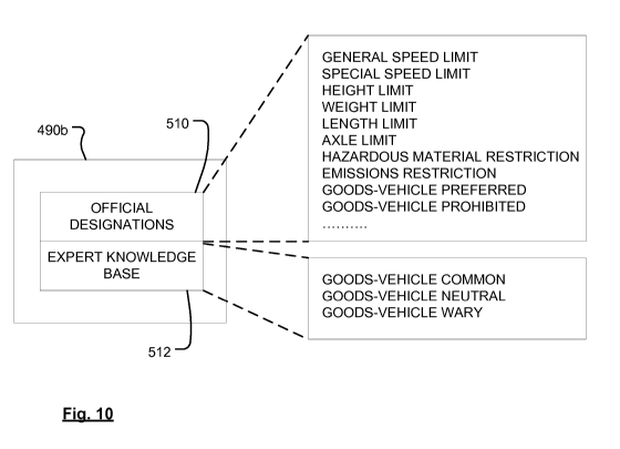
Fig. 10 illustrates one example of a format for the supplementary road
information 490b. The information may be organised or compartmentalised
directly
using the format, or it may just be organisable or identifiable using this
format. For
example, the information fields may be identified by tags or labels, although
organised in
a different way. Not all of the fields need be used for every road. Typically,
only
necessary fields for road information would be used. The supplementary road
information 490b for a road may include official designation information 510
and expert-
knowledge-base information 512. Official designation information 510 includes
information from government sources or road signs, for example, a speed limit,
a special
speed limit, a height limit, a weight limit, a length limit, axle limit,
hazardous material
restriction, an emissions restriction, a goods-vehicle-preferred designation,
a goods-
vehicle restricted designation. Expert-knowledge-base information 512 includes
information not originating from official sources, but instead from analysis
of road use. In
the context of the present invention, the expert-knowledge-base information
512
includes at least suitability of the road for use according to vehicle
category, based on a
statistical analysis of a history of road usage by vehicle category. For
example, the
suitability may be indicated for goods vehicles by: good-vehicle-common, goods-
vehicle-
neutral, or goods-vehicle-wary. Similar designations may be used for each
vehicle
category of interest.
The application software 480 may include one or more software modules as
described below. Although the modules are represented separately, it will be
appreciated that this is merely for the sake of explanation. Functionality may
overlap
between modules, and/or one module may comprise another, and/or more modules
may
be provided. The modules may include one or more of :
a graphical user interface (GUI) module 482 that supports other modules by
providing a unified input/output interface, and provides an image renderer for
map
views;
a positioning system (e.g. GPS) module 484 for implementing real-time position
determination to generate current position information, optionally interfacing
with
external positioning system hardware as described hereinbefore;
CA 02725982 2010-11-25
WO 2010/081540 PCT/EP2009/050370
19
a vehicle/route criteria module 486 for inputting and/or storing information
concerning the type of vehicle, a start location, a destination location and
optionally
one or more waypoints for a navigation route, and the type of navigation route
desired;
a route planning module 488, responsive to information contained in a digital
map 490 and to information from the vehicle/route criteria module 486, for
calculating
a navigation route from the start location to the destination location. The
digital map
490 is also stored by the memory resource 230.
a navigation module 492, responsive to (i) the current position information
from
the positioning system module 482, (ii) the digital map 490, and (iii) the
calculated
route from the route planning module 488; for implementing real-time
navigation
guidance for guiding a vehicle driver to navigate along the calculated route.
The
navigation module 492 may generate audio and/or visual guidance prompts to aid
navigation step-by-step. In the event that the navigation module 492
determines,
from the current position information, that the vehicle has deviated
substantially from
the calculated route, the navigation module 492 may issue a re-route command
494
to the route planning module 488, to calculate a new route taking account of
the
vehicle's current position;
a data logging module 496 for logging trip information. The trip information
may
include information from one or more of: the positioning system 484, route
planning
module 488, navigation module 492, vehicle/route criteria module 486, and the
digital
map 490 (useful if the position information is coded with respect to
information from
the digital map). In Fig. 6 information flow for the purposes of data logging
is
indicated by broken lines.
Fig. 7 illustrates one example of information that is input and/or stored by
the
vehicle/route criteria module 486. Vehicle information 500 is intended to
identify a
category of vehicle. The collection or set of vehicle parameters may be
referred to as a
vehicle profile. The vehicle information 500 may include the vehicle type or
category
502 (for example, selected from a predetermined list of car, goods-vehicle,
bus, etc.),
trailer information 504 (such as car+caravan, or articulated lorry trailer).
For vehicles
larger than standard cars, the vehicle information may additionally include
vehicle height
506, vehicle width 508, vehicle length 510, vehicle weight unladen 512,
optionally
vehicle weight laden 514 for goods-vehicles, hazardous material contents 516
for goods-
vehicles. Various other vehicle parameters may also be stored, and/or one or
more of
the above parameters may be omitted as desired. The information may be freely
inputtable as discrete values by a user, or selected from predetermined value
ranges
CA 02725982 2010-11-25
WO 2010/081540 PCT/EP2009/050370
(such as for weight (in metric tonnes), ranges of 1-5, 5-10, 10-15, 15-20,
etc.). Some of
the information may also be determined inherently from other information. For
example,
if a goods-vehicle is identified by a goods-vehicle classification type or by
a vehicle
model identifier, then one or more of the parameters may be inferred from such
5 information without requiring separate input. When the navigation device is
implemented as a PND, the vehicle/route criteria module 486 preferably
includes an
interface for enabling the user to set or adjust vehicle information values.
Additionally or
alternatively, values may be set by software executed on a user's home
computer when
connected to the PND. When the navigation device is implemented as in-vehicle
10 equipment that is permanently installed in a single vehicle instead of as a
PND, at least
some of the vehicle parameters may be pre-set at manufacture or installation.
The
vehicle/route criteria module 486 may optionally be configured to obtain the
vehicle
information from an in-vehicle identification unit (not shown). The navigation
unit 200
may establish a communication connection with the in-vehicle identification
unit by any
15 suitable means, such as via wireless connection (e.g. Bluetooth) or a wired
connection
or wired bus, such as a Controller Area Network bus (CAN-bus), which is a bus
protocol
that is widely used in the automotive industry for implementing a distributed
communications network between discrete in-vehicle devices.
The vehicle/route criteria module 486 further provides an interface for route
20 information 520, including for example, a start location 522, a destination
location 524,
one or more intermediate waypoint locations 526, time of day (or desired time
of arrival)
528, and route-type preferences typically indicated by flags indicating
preferences
according to their state (selected or deselected). Example flags include one
or more of:
toll-road use 530, motorway use 532, scenic-route use 534, fastest-route 536,
safest-
route 538, goods-vehicle-route 540, caravan-route 544. Additional preferences
may also
be provided, and/or one or more of the above preferences may be omitted, as
desired.
The preferences may be freely settable, and/or one or more preferences may be
pre-set
(either in a fixed manner, or an initial default manner) according to the
vehicle
information 500. For example, if the vehicle information indicates the vehicle
to be a
goods-vehicle, the goods-vehicle-route flag 540 may be pre-set to its selected
state, and
at least the scenic-route flag 536 may be pre-set to its deselected state. The
preference
flags are used by the route planning module 488 for determining an optimum
route for
the vehicle to follow that satisfies the preference criteria. For example, in
the case of the
goods-vehicle-route flag 540 being selected, the navigation route is
calculated to
optimise the route in accordance with the goods-vehicle-specific supplementary-
road
information 490b in the digital map 490. The navigation route avoids roads
whose limits
CA 02725982 2010-11-25
WO 2010/081540 PCT/EP2009/050370
21
or restrictions would be exceeded by the goods-vehicle parameters, or where
the road is
designated as goods-vehicle-wary. Roads that are goods-vehicle-suitable
(either goods-
vehicle-preferred or goods-vehicle-common) are weighted more favourably for
inclusion
in the navigation route, or the navigation route may be calculated to use
exclusively
roads designated as goods-vehicle-suitable where possible. In one form, when
vehicle
characteristics such as weight and size are stored by the vehicle/route
criteria module
486, the route planning module 488 always compares these values with
supplementary
road information 490b even if the goods-vehicle route flag is not in its
selected state.
The goods-vehicle route flag 540 is then used to select navigation on roads
designated
as goods-vehicle-suitable (goods-vehicle-preferred or goods-vehicle-common),
and to
avoid goods-vehicle-wary roads. In another form, the comparison of vehicle
weight and
size, with respect to supplementary road information, is only conducted by the
route
planning module 488 when the goods-vehicle-route flag 540 is in its selected
state. One
or more additional preference flags may be provided in order to provide sub-
preferences
for controlling separately which of the vehicle parameters for goods-vehicles
are used in
route planning. For example, separate preference flags may be provided for (i)
vehicle
parameters such as size and weight, and (ii) roads that are goods-vehicle-
suitable.
Additionally or alternatively, separate preference flags may be provided for
distinguishing
between roads that are (i) goods-vehicle-preferred, and (ii) goods-vehicle-
common, if a
distinction is made between such information in the supplementary road
information
490b of the digital map 490.
In one form, the vehicle/route criteria module 486 may enable the criteria to
be
programmed differently for different portions of a journey. For example, a
navigation
route may be calculated for a goods-vehicle travelling laden from a departure
point to a
drop-off waypoint, and then returning unladen to its final destination (which
may typically
be the same as the departure point). In such case, the vehicle weight may
change at
the drop-off waypoint, allowing a different and perhaps shorter route to be
used for the
return portion of the journey. Alternatively, two different, independent
journeys may be
calculated with different vehicle parameters.
The data logging module 496 serves to log trip information, which may also be
referred to as a trace of the determined position over time (sometimes called
a "GPS
trace"). Various techniques for logging, coding and/or compressing the
information may
be used. Techniques may include one or more selected from (i) position-
sampling of the
real time position of the vehicle, such that the position information is
logged each time
that displacement by a certain threshold is detected, (ii) time-sampling of
the real-time
position of the vehicle, such that the position information is logged at a set
time interval,
CA 02725982 2010-11-25
WO 2010/081540 PCT/EP2009/050370
22
(iii) a combination of both position and time sampling, (iv) event-logging of
significant
events, such as changes in the vehicle parameters or route preferences, or
deviation
from a navigation route, re-calculation of the navigation route, advancement
along the
navigation route, or arrival at a junction, or arrival at a waypoint or
destination. The trip
information may be recorded as one or more of: real-position co-ordinates
(e.g. GPS co-
ordinates); co-ordinates with respect to the digital map; a position on a road
depicted in
the map; a position along a planned navigation route. The logged data may
optionally
include time and/or date stamp information obtained from the current time and
date
function provided by the operating system 470. It will be appreciated that
such
information may be represented in any desired format. For example, the date
may be
represented by a annual calendar date, or a day of the month, or a day of the
week. The
logged data may further include information identifying or defining the
planned
navigation route. The logged data is intended to facilitate simulation or re-
construction
of the movements of the navigation device or vehicle, to permit journey
analysis.
The data logging module 496 also serves to upload the logged data to the
server
150 (step 498) when a connection is available. If the connection is via a
wireless path
(or via a permanent or so-called generally-present path), a connection may be
established periodically, either automatically or at the request of the data
logging module
496. If the connection is via a wired path, e.g. using a user's fixed computer
(such as for
a PND), the connection may be established whenever the user couples the
navigation
device 200 to the home computer. The data uploaded to the server 150 includes
the trip
information, and vehicle information based on the vehicle parameters. The
vehicle
information may be stored as part of the logged data, or it may be read from
the
vehicle/route criteria module 486 at the time of upload. Storing the vehicle
information
as part of the logged data enables any changes to the vehicle information to
be recorded
in time sequence with the trip information for the vehicle. This may be
significant for a
PND which might be used with different vehicles, or for a goods-vehicle making
trips
laden or unladen, or with different laden weights.
Referring to Fig. 8, the server 150 receives trip information uploaded from
plural
navigation devices 200, stores this in an upload library 400, and executes a
statistical
analyzer 402 to process the trip information to derive statistical analyses.
While the trip
information for an individual journey may be influenced by unique journey
events,
analysing trip information from multiple devices enables driver habit, journey
time
patterns and route patterns to be derived statistically. The statistical
analyzer 402 is
programmed to recognise certain characteristics indicative of information
desired to be
derived.
CA 02725982 2010-11-25
WO 2010/081540 PCT/EP2009/050370
23
Referring to Fig. 9, in the preferred embodiment, the statistical analyzer 402
is
configured to derive information regarding the route patterns taken by
vehicles according
to their vehicle parameters or category, especially large vehicles such as
goods-vehicles
and buses, or by articulated vehicles, such as car+caravan combinations. At a
first step
602, the vehicle type from the logged information is compared to identify one
of the
above category of vehicle of interest, for example, a goods-vehicle. If the
vehicle is of a
category of interest, the vehicle characteristics are derived at step 604. At
step 606, the
route taken by the vehicle is analyzed, and compared statistically with other
routes used
by goods-vehicles. The statistical comparison may be performed using any
suitable
technique. For example, the route may be divided into segments, which may
correspond to individual roads or road portions between junctions or
significant junctions
if preferred. At step 608, roads determined to be used commonly by goods-
vehicles are
designated as "goods-vehicle-common". At step 610, a determination is made of
whether the goods-vehicle was following a planned route and, if so, step 612
determines
whether the goods-vehicle deviated from the route. In case of deviation, step
614
performs a statistical analysis to determine whether the deviation follows a
pattern of
other deviations from planned routes made by goods-vehicles. While, a goods-
vehicle
may deviate from a planned route of an individual journey for any of a number
of
reasons, if a statistical analysis reveals a trend of goods-vehicles tending
to avoid a
certain road or junction or turn for no apparent reason (such as known
roadworks or
temporary deviation in place for all goods-vehicles), this is indicative of
the goods-
vehicles finding the planned route awkward for some reason, or experienced
goods-
vehicle drivers using their own personal knowledge of a better route. If
desired,
verification of the effectiveness of the alternative route pattern may be
confirmed by
observing the speed profile of the vehicles from the logged trip information,
and/or the
journey times. At Step 616 roads or junctions around which deviations are
routinely
taken by goods-vehicles for no other known reason, are designated as "goods-
vehicle-
wary".
Additionally or alternatively, referring to Fig. 11, the statistical analyzer
402 may
be configured to derive information concerning journey time patterns according
to
vehicle category. At step 650, the route taken by a vehicle is analyzed, and
divided into
segments, which may correspond to individual roads or road portions between
junctions
or significant junctions if preferred. At step 652, the journey time along
each segment is
determined according to the logged date-time information. At step 654, the
journey time
is compared statistically with other journey times derived historically. For
example,
clusters of journey times may be derived. At step 656, the journey time (or a
cluster
CA 02725982 2010-11-25
WO 2010/081540 PCT/EP2009/050370
24
grouping) is analysed to determine respective characteristics, or unifying
characteristics
in the cause of a cluster grouping. One of the (unifying) characteristics may
be the
vehicle category. For example, cars may generally travel along a route more
quickly
than goods vehicles. This may be apparent in town centres where cars are able
to
manoeuvre, accelerate and decelerate more quickly than goods vehicles. On
motorways, goods vehicles may have to observe a lower speed limit than cars.
Another
(unifying) characteristic may be the type of day (for example, a school-day,
or a working
day, or a non-working day), and/or the time of day (for example, whether at
time of
habitually peak-traffic, or a time of habitually calmer traffic). At step 658,
supplementary
information is generated to provide an indication of journey time for a road
or road
segment, based on the historical pattern of journey times, and with a
respective journey
time according to the different characteristics such as vehicle category, day
type, and
time of day.
Returning to Fig. 8, following processing by the statistical analyzer 402,
processing proceeds to a digital map updater 404 for updating the working
version of the
digital map at the server 150. Updates from the digital map will then be
available for
download to each navigation device 200 served by the server 150, upon a
subsequent
connection by each navigation device 200. The download updating step is
indicated at
499 in Fig. 6. Thus navigation devices 200 are able to collect, and
subsequently be
supplied with, updated and refined goods-vehicle-specific information.
The preferred embodiment therefore permits collection of an extremely valuable
source of expert knowledge for large or special vehicles, such as goods-
vehicles, buses
and car+caravan combinations. Such information can refine navigation route
planning
for such categories of vehicles, enabling inexperienced drivers or drivers
having to
navigate vehicles through unfamiliar areas, to benefit from expert knowledge
of others.
Such information is impossible to collect using existing map-making
techniques, and
cannot be distilled from conventional sources such as official government
designations
of roads and road sign analysis. Moreover, the technique of the invention does
not
require additional map-making hardware, yet enables information to be
collected easily
and thoroughly in a highly automated and cost-effective manner.
It will also be appreciated that whilst various aspects and embodiments of the
present invention have heretofore been described, the scope of the present
invention is
not limited to the particular arrangements set out herein and instead extends
to
encompass all arrangements, and modifications and alterations thereto, which
fall within
the scope of the appended claims.
For example, whilst embodiments described in the foregoing detailed
description
CA 02725982 2010-11-25
WO 2010/081540 PCT/EP2009/050370
refer to GPS, it should be noted that the navigation device may utilise any
kind of
position sensing technology as an alternative to (or indeed in addition to)
GPS. For
example the navigation device may utilise using other global navigation
satellite systems
such as the European Galileo system. Equally, it is not limited to satellite
based but
5 could readily function using ground based beacons or any other kind of
system that
enables the device to determine its geographic location.
Additionally, the enhanced content of a digital map may be used by other
devices, such as navigation servers, that might not themselves log trip data.
For
example, several internet web-sites offer the possibility of route planning
from a start
10 location to a destination location, according to user-selectable criteria.
The results may
be downloaded or printed for later use. By providing enhanced supplementary
information in a digital map, such users may also benefit from enhanced goods-
vehicle-
specific information. The invention extends to cover such use without logging
of new trip
data.
15 It will also be well understood by persons of ordinary skill in the art
that whilst the
preferred embodiment implements certain functionality by means of software,
that
functionality could equally be implemented solely in hardware (for example by
means of
one or more ASICs (application specific integrated circuit)) or indeed by a
mix of
hardware and software. As such, the scope of the present invention should not
be
20 interpreted as being limited only to being implemented in software.
Lastly, it should also be noted that whilst the accompanying claims set out
particular combinations of features described herein, the scope of the present
invention
is not limited to the particular combinations hereafter claimed, but instead
extends to
encompass any combination of features or embodiments herein disclosed
irrespective of
25 whether or not that particular combination has been specifically enumerated
in the
accompanying claims at this time.