Note: Descriptions are shown in the official language in which they were submitted.
CA 02726515 2010-11-30
WO 2010/005778 PCT/US2009/048273
1
LOCATION SPECIFIC SEARCH
FOR REGIONAL SATELLITE VEHICLES
BACKGROUND
[0001] This disclosure relates generally to position location and, more
particularly, to
positioning with signals from regional satellite systems.
[0002] Global navigation satellite systems (GNSS) provide positioning data to
users
throughout the world. Using information from different GNSS satellites, it is
possible
to determine location within a global coverage area and to synchronize with
satellite
time.
[0003] More recently, regional satellite systems have been developed to
augment
existing GNSS systems. Regional satellite systems serve specific parts of the
world
and, among other things, aim to improve the accuracy, integrity, and
availability of
global satellite positioning within their respective service areas.
[0004] Mobile devices are increasingly available which can receive and process
signals from both global and regional satellite systems. By their very nature,
these
devices change position and can therefore move into and out of the coverage
areas of
different regional satellite systems.
[0005] As a result, a mobile device may search for a regional satellite
vehicle that is
not accessible from its current location. This fruitless search wastes time,
power, and
search capacity and thus degrades positioning performance. Alternatively, the
mobile
device may be programmed to wait until after a position fix is obtained before
determining the availability of regional satellites. This also lengthens the
time needed
to arrive at a fully accurate position and results in reduced performance.
BRIEF SUMMARY OF EMBODIMENTS
[0006] A position location system, method, and apparatus are disclosed. A
wireless
device receives a first signal and obtains an identifier indicative of a first
location from
the first signal. The first signal can be received from a cellular base
station and the first
identifier can be a mobile country code. The wireless device uses the
identifier to
determine the availability of signals from a regional satellite system at the
first location.
CA 02726515 2010-11-30
WO 2010/005778 PCT/US2009/048273
2
If signals from the regional satellite system are available at the first
location, the
wireless device retrieves information associated with one or more satellite
vehicles in
the regional satellite system. The information can be maintained at the
wireless device
and can include pseudo-random number codes or other satellite identifiers as
well as a
Doppler search range corresponding to the first location. The wireless device
processes
satellite signals from the one or more satellite vehicles and determines its
position based
at least partly on information obtained from the satellite signals. The
wireless device
can process signals from the regional satellite system while also processing
for signals
from one or more global positioning satellite systems.
[0007] In one embodiment, a position location method is disclosed. The method
includes receiving a first signal and obtaining an identifier from the first
signal
indicative of a first location. The method also includes retrieving
information
associated with at least one satellite vehicle using the identifier wherein
the at least one
satellite vehicle belongs to a regional satellite system. The method includes
receiving a
second signal and processing the second signal to obtain first satellite
signal information
for the at least one satellite vehicle. The method includes determining a
position of the
wireless device at least partially based on the first satellite signal
information. The
method can include determining an orbital type of the at least one satellite
vehicle and
retrieving a Doppler search range corresponding to a Doppler shift at the
first location if
the orbital type is determined to be geosynchronous. The Doppler search range
limits a
search for the first satellite signal. In some embodiments, the method
includes
processing the second signal to obtain second satellite signal information
from at least
one satellite vehicle that is part of a global navigation satellite system
(GNSS) while
obtaining the first satellite signal information.
[0008] In one embodiment, a wireless device is disclosed. The wireless device
includes a first receiver configured to receive an information bearing signal
having a
first identifier indicative of a first location. The wireless device also
includes a second
receiver configured to receive a plurality of satellite signals and to
determine a position
of the wireless device using information from the plurality of satellite
signals, wherein
the second receiver receives at least one of the plurality of satellite
signals using second
identifiers for satellite vehicles that are part of a regional satellite
system. The wireless
device also has a processor configured to obtain the first identifier from the
information
bearing signal and to retrieve the second identifiers from a memory of the
wireless
CA 02726515 2010-11-30
WO 2010/005778 PCT/US2009/048273
3
device based on the first identifier. The processor can also be configured to
determine
an orbital type of the satellite vehicles that are part of the regional
satellite system and to
retrieve a Doppler search range from the memory if the orbital type is
geosynchronous
but not necessarily geostationary. The second receiver limits a search for a
carrier
frequency of the at least one of the plurality of satellite signals based on
the Doppler
search range. In some embodiments, the second receiver receives signals from a
global
navigation satellite system using third identifiers and concurrently receives
the at least
one of the plurality of satellite signals using the second identifiers.
[0009] In one embodiment, a position location method for a mobile device is
disclosed. The method includes maintaining information associated with
satellite
vehicles of regional satellite systems in a memory of the mobile device and
receiving a
terrestrial signal from a cellular base station. The terrestrial signal
contains an identifier
indicative of a first location. The method also includes determining the
availability of a
first regional satellite system at the first location based on the identifier
and retrieving
from the memory a pseudo-random number code corresponding to a first satellite
vehicle of the first regional satellite system if the first regional satellite
system is
available at the first location. The method includes receiving a second signal
and
processing the second signal using the pseudo-random number code to obtain
first
satellite signal information. . The method also includes determining a
position of the
mobile device at least partially based on the first satellite signal
information.
[0010] In one embodiment, a computer-readable medium encoded with one or more
instructions for locating the position of wireless devices is disclosed. The
one or more
instructions include instructions which, when executed by one or more
processors,
cause the one or more processors to perform steps of receiving a first signal,
obtaining
an identifier from the first signal indicative of a first location, and
retrieving information
about at least one satellite vehicle using the identifier. The at least one
satellite vehicle
is part of a regional satellite system. The steps performed by the one or more
processors
also include receiving a second signal, processing the second signal to obtain
first
satellite signal information for the at least one satellite vehicle, and
determining a
position of the wireless device at least partially based on the first
satellite signal
information.
CA 02726515 2010-11-30
WO 2010/005778 PCT/US2009/048273
4
BRIEF DESCRIPTION OF THE DRAWINGS
[0011] Fig. IA is a high-level block diagram of an embodiment of a
communication
system including a global satellite navigation system and a regional satellite
system.
[0012] Fig. lB shows a further embodiment of a communication system including
a
global navigation satellite system and two regional satellite systems in
relation to a
particular geographic area.
[0013] Fig. 2 is a functional block diagram of a mobile device such as can be
used
with the communication systems of Figs lA-lB.
[0014] Figs. 3A-3B show exemplary data structures for storing information
about
regional satellite systems.
[0015] Fig. 4 is a flowchart illustrating one embodiment of a position
location method
for use with a wireless device.
[0016] The features, objects, and advantages of embodiments of the disclosure
will
become more apparent from the detailed description set forth below when taken
in
conjunction with the drawings, in which like elements bear like reference
numerals.
DETAILED DESCRIPTION OF EMBODIMENTS
[0017] Fig. IA is a high-level block diagram of a communication system 100A in
accordance with one embodiment of the present invention. As shown, mobile
device
140 can receive signals from global navigation satellite system (GNSS) 110,
regional
satellite system (RNSS) 120, and transmitter 130. Mobile device 140 uses
information
obtained from transmitter 130 to determine the availability of satellite
signals from
particular RNSS satellite vehicles (hereinafter also "SVs" and "satellites")
and to limit a
Doppler search for such satellite signals. Advantageously, by using
information from
transmitter 130, mobile device 140 searches for specific regional SVs from
which
signals are most likely available at its current location before it has
acquired a position
fix. Additionally, mobile device 140 can limit the search for signals from the
regional
SVs to a location-specific Doppler search range.
[0018] Global navigation satellite system 110 includes one or more satellite
navigation systems which provide positioning data to users throughout the
world. For
example, GNSS 110 can include the Navigation Signal Timing and Ranging Global
CA 02726515 2010-11-30
WO 2010/005778 PCT/US2009/048273
Positioning System (GPS) operated by the United States. In general, each GPS
satellite
vehicle modulates a carrier such as the L1 frequency (1575.42 MHz) with a
pseudo-
random number code (PRN) and a navigation message. The PRN identifies the
particular SV which transmitted the signal, and is used by a receiver to
determine the
5 time between transmission of the signal at the satellite vehicle and the
time of reception
at the receiver, from which the distance between the satellite and the
receiver can be
determined and used for position determination. The navigation message
contains orbit
information (ephemeris data relating to the transmitting SV's orbit as well as
almanac
information with approximate positions for other SVs in the GPS satellite
constellation),
along with other information such as the time information (e.g. time of week
or TOW).
Although the GPS system is used here for purposes of discussion, it will be
recognized
that GNSS 110 can include other global satellite navigation systems such as
the
GLONASS system operated by Russia, the Galileo system under development by the
European Union, and global satellite navigation projects such as the COMPASS
system
scheduled for future deployment by China. The different satellite systems may
use
different schemes for transmitting information to be used for position
determination.
For example, satellites of the GLONASS system each use the same PRN code,
transmitted on different frequency channels. However, the techniques described
herein
are not limited to particular message types or transmission schemes.
[0019] Regional satellite system 120 includes satellite vehicles which augment
the
capability of GNSS 110. RNSS satellite vehicles typically have either
geostationary or
geosynchronous orbits and, as a result, they are visible only in certain parts
of the world.
In other words, RNSS 120 serves a particular geographic region ("coverage
area")
defined by the orbits of its particular satellites. For example, RNSS 120 can
include the
Wide Area Augmentation System (WAAS) covering the United States, the Euro
Geostationary Navigation Overlay Service (EGNOS) covering Europe and
surrounding
areas, the MTSAT Satellite-based Augmentation System (MSAS) serving Japan, and
the Quasi-Zenith Satellite System (QZSS). It will be understood that RNSS 120
can
also include other regional satellite systems such as the GPS Aided Geo
Augmented
Navigation (GAGAN) and Indian Regional Navigation Satellite System (IRNSS)
systems under development by India and other like systems.
[0020] Satellite vehicles in RNSS 120 transmit messages with positioning data.
Typically, the RNSS messages are transmitted on the same carrier frequency as
SVs in
CA 02726515 2010-11-30
WO 2010/005778 PCT/US2009/048273
6
GNSS 110 but are coded to identify a particular RNSS satellite and use a
different
message format. Regional satellite systems like WAAS and EGNOS use ground
stations to monitor the GNSS satellite vehicles in their respective service
areas. The
ground stations upload correction data to regional SVs which then transmit the
correction data in coded satellite messages. One aspect of RNSS 120 is to
improve the
accuracy, integrity, and reliability of global navigation systems such as GPS
and
GLONASS.
[0021] Mobile device 140 is a wireless device that can receive satellite
positioning
and other communication signals. For example, mobile device 140 can be a
cellular
telephone with a position location capability. As shown, mobile device 140
receives
voice and data signals from a transmitter 130 such as a cellular base station.
However,
mobile device 140 is not limited to a cellular telephone, and can also include
a personal
digital assistant, notebook computer, smartphone, and like communication
devices. In
some embodiments, mobile device 140 receives FM radio signals, digital
television
signals, and wired/wireless network communications such as Ethernet, Wi-Fi,
WiMAX
(Worldwide Interoperability for Microwave Access), and the like.
[0022] Transmitter 130 provides a signal with information indicative of its
general
location or service area. In an exemplary embodiment, transmitter 130 is a
cellular base
station and its service area is identified by a country code or similar datum.
However,
transmitter 130 can include other terrestrial and/or satellite sources such as
FM radio
stations, digital television broadcasts, and wireless or wired data networks.
In one
embodiment, transmitter 130 is a wireless access point which provides NITZ
(Network
Identity and Time Zone) information to its clients. World (absolute) time
zones, for
example, correspond to distinct geographic regions and can therefore serve as
location
identifiers. In another embodiment, transmitter 130 is a server which can
provide
mobile device 140 with a network address or similar identifier. For example,
an
Internet service provider can assign a client computer an IP (Internet
Protocol) which
corresponds roughly to a geographic location.
[0023] Mobile device 140 uses the location information from transmitter 130 to
determine the availability of RNSS 120 satellite vehicles. If the location
information
indicates a country in Europe, for example, then mobile device 140 can
determine that it
is likely within the EGNOS coverage area and can search for EGNOS satellite
vehicles.
CA 02726515 2010-11-30
WO 2010/005778 PCT/US2009/048273
7
Similarly, if the location information indicates the United States, then
mobile station
140 can determine that it is likely within the WAAS coverage area and can
limit its
search accordingly. Since RNSS 120 satellite vehicles maintain geostationary
or
geosynchronous orbits and provide correction data for use within their
specific coverage
areas, mobile device 140 avoids searching for SVs that are not visible and/or
do not
have data which can be used to determine its position.
[0024] By way of illustration, assume that mobile device 140 is located
somewhere in
Europe and that it does not have a position fix. Also assume that mobile
device 140
lacks data which may have been acquired from a previous position fix, or that
prior
positioning data has become stale. In this cold-start condition, mobile device
140 lacks
information about the availability of RNSS 120 satellite vehicles. However, if
mobile
device 140 has received signals from a base station (even prior to the current
power-on
condition), it may have obtained a mobile country code (MCC) or similar
geographic
identifier. For example, when activated, mobile device 140 may have
automatically
acquired signals from a serving base station indicating that it is somewhere
in Germany.
Using this information, mobile device 140 determines that it is within the
EGNOS
coverage area and identifies specific EGNOS (regional) satellite vehicles from
which it
can receive positioning data. This can be done in parallel with a search for
global
satellite vehicles in GNSS 110 thereby accelerating the process of obtaining
an accurate
position fix. Alternatively, mobile device can use health information obtained
from the
SVs of RNSS 120 to further refine its search for GNSS satellites.
[0025] Fig. lB is a diagram illustrating aspects of a communication system
100B in a
specific geographic area. As shown, satellite vehicles of GNSS 110 and RNSS
120
have a coverage area which includes Japan. Mobile device 140 is a personal
digital
assistant (PDA) which receives signals from transmitter 130 as well as from
global
navigation satellites 110-G and regional satellites 120-MT, 120-QZ.
[0026] In the presently described embodiment, RNSS 120 includes two regional
systems. The first regional system is the MTSAT Satellite-based Augmentation
System
(MSAS) represented by satellite vehicle 120-MT. MSAS satellite 120-MT
maintains a
geostationary orbit above Japan and provides augmentation data as previously
discussed. Satellite vehicles 120-QZ1, 120-QZ2 are part of the Quasi-Zenith
Satellite
System (QZSS). QZSS satellites 120-QZ maintain a geosynchronous orbit having a
CA 02726515 2010-11-30
WO 2010/005778 PCT/US2009/048273
8
coverage area (ground track) extending roughly from Japan to Australia. The
orbit of
QZSS satellite vehicles 120-QZ is known and thus their elevation and Doppler
characteristics can be determined on a country-by-country basis throughout the
coverage area.
[0027] Mobile device 140 receives an identifier from transmitter 130
indicative of a
geographic area. As previously noted, different identifiers may be used and
may have
varying degrees of precision. A world time-zone identifier, for example, may
indicate
only that the location (Japan) is within a particular 15-degree longitudinal
slice of the
earth. On the other hand, a country code or similar identifier may indicate
that the
location is Japan or possibly one of the Japanese islands.
[0028] Using the identifier, mobile device 140 retrieves information about the
availability of RNSS 120 satellite vehicles. In the case of Japan, mobile
device 140
determines that both MSAS and QZSS satellite vehicles are available in
addition to the
GNSS 110 global navigation satellites. Similarly, mobile device 140 can
eliminate SVs
in the WAAS and EGNOS systems as possible search candidates.
[0029] After determining the availability of one or more regional satellite
systems,
mobile device 140 prioritizes a search for SVs. For example, QZSS satellites
120-QZ
are expected to transmit GPS-interoperable signals for position location as
well as
correction data for GNSS satellites 110-G within the QZSS coverage area.
Similarly,
the orbits of the QZSS satellite vehicles will be such that at least one is at
a high degree
of inclination above Tokyo nearly all of the time. Mobile device 140 can store
this and
other information about RNSS 120 and its particular SVs and can use it to
prioritize the
search for positioning signals.
[0030] Beyond the availability of regional satellite systems, mobile device
140 can
access information with which to limit the search for signals from a
particular regional
satellite vehicle. This can include limiting a Doppler search for QZSS
satellite vehicles
based upon the location identifier received from transmitter 130. For example,
the
Doppler shift of signals from QZSS satellite vehicles 120-QZ is location
dependent. It
is generally about 250 m/s in Japan, but can reach 500 m/s in Australia. In
the worst-
case scenario, the QZSS Doppler shift is around 650 m/s. Thus, if the
identifier
indicates Japan as being the rough location, the search range for the QZSS
satellite
CA 02726515 2010-11-30
WO 2010/005778 PCT/US2009/048273
9
vehicles 120-QZ can be restricted to frequencies corresponding to Doppler
shifts of
about 250 m/s to significantly improve search times.
[0031] It will be recognized that the present invention is not limited to a
particular
geographic region or to a particular regional satellite system. Instead,
embodiments of
the present invention broadly encompass determining the availability of RNSS
systems
based upon a location identifier and identifying satellite vehicles within the
available
RNSS systems. Also, it will be understood that satellite identifiers such as
pseudo
random number (PRN) codes and frequency channel numbers can be used to
identify
specific SVs within a regional satellite system. Frequency channel numbers,
for
example, can be used with satellite systems like Glonass which transmit
signals using
frequency division multiple access (FDMA) or like techniques. Information
about
available RNSS systems and their satellites is accessed to improve search
performance
and enhance position location determination. Accordingly, it is specifically
contemplated that embodiments of the present invention can be used with
existing and
future regional satellite systems without limitation.
[0032] Fig. 2 is a functional block diagram of an embodiment of mobile device
140.
As shown, mobile device 140 includes an RF transceiver 220 and a satellite
receiver 260
both of which are coupled to antenna 210. RF transceiver 220 is also coupled
to
baseband processor 230. On the receive path, RF transceiver 220 receives an
incoming
RF signal and delivers it to baseband processor 230. Baseband processor 230
recovers
information from the RF signal. For example, baseband processor 230 can
demodulate
and decode the received signal in addition to performing other signal
processing
functions. On the transmit path, baseband processor 230 performs coding and
modulation of data received from processor 240 and delivers the outgoing RF
signal to
RF transceiver 220.
[0033] In various embodiments, processor 240 obtains a location identifier
from the
data recovered by baseband processor 230. As previously discussed, the
location
identifier can be a country code transmitted by a cellular base station, world
time zone
information, network address, or like data indicative of a particular
geographic area.
Memory 250 stores information for determining the availability of one or more
regional
satellite systems as well as identifiers for the particular regional satellite
vehicles.
Additionally, memory 250 may store Doppler search ranges for the regional
satellite
CA 02726515 2010-11-30
WO 2010/005778 PCT/US2009/048273
vehicles at particular locations. In some embodiments, memory 250 includes a
non-
volatile storage element such as a flash memory or battery-powered static
random
access memory (SRAM) device.
[0034] Figs. 3A-3B show exemplary data structures 300 such as can be used to
supply
5 information about a satellite in a regional satellite system. Each data
structure may
include an array of individual data elements and may be stored in memory 250
for
access by processor 240. For example, data structures 300 may include data
elements
for each satellite in each regional satellite system. In some embodiments,
memory 250
stores several different data structures 300 each of which can be indexed
according to
10 one or more location identifiers and which can be updated by processor 240.
[0035] Data structure 300A includes exemplary information relating to
satellite
vehicles in a regional satellite system organized by Country-Code 310. As
shown,
RNSS_ID 320, SV Name 330, and SVID 340 values are provided for regional
satellites by country code 310. In one embodiment, country code 310
corresponds to a
list of mobile country codes (MCC) such as that promulgated in ITU E. 212
(Recommendation 212 from the International Telecommunication Union). RNSS_ID
320 corresponds to a particular regional satellite system such as WAAS, EGNOS,
MSAS, QZSS etc. SV Name 330 is the name of a particular satellite vehicle
within the
RNSS indicated by RNSS_ID. SVID 340 is an identifier such as a pseudo-random
number (PRN) code corresponding to a PRN used by the regional satellite
vehicle to
code its transmissions. Orbital 350 indicates whether the satellite vehicle
(SV Name) is
in geosynchronous, geostationary, or other earth orbit. For satellite vehicles
in
geostationary orbits, Doppler search range 360 may be zero or omitted.
Otherwise,
Doppler search range 360 can specify a value for use in limiting a search for
the carrier
signal of SV Name 330 at the location indicated by country code 310.
[0036] For illustrative purposes, data structure 300A is shown with exemplary
data
elements for country code 208 (France), 441 (Japan), and 505 (Australia).
France is
within Europe and thus the RNSS_ID corresponding to country code 208 is EGNOS.
Within the EGNOS regional satellite system, satellite vehicles AOR-E, ARTEMIS,
and
IND-W are identified as being potential search candidates for locations in
France. The
pseudo-random number codes of the EGNOS satellite vehicles are 120, 124, and
126
respectively. As indicated, these satellite vehicles maintain geostationary
orbits
CA 02726515 2010-11-30
WO 2010/005778 PCT/US2009/048273
11
(GEOSTAT) and hence their Doppler shifts are typically very small. For
example, the
Doppler shift associated with WAAS satellite vehicles in the United States may
be on
the order of about 40 m/s (that is, a frequency shift corresponding to a
relative velocity
of the satellite toward/away from the receiver of about 40 m/s). Thus, in
some
embodiments, a Doppler search value of zero may be used for geostationary
regional
satellite vehicles. In other embodiments, data structures 300 may store more
precise
measured values of Doppler shift and/or Doppler search ranges for each
regional
satellite vehicle at each geographic location.
[0037] As previously discussed, Japan is within the coverage area of both the
MSAS
and QZSS regional satellite systems. Thus, country code 441 includes
information
about satellite vehicles in both regional satellite systems. The exemplary
data element
for Japan indicates the availability of satellite vehicle QZS1 in the QZSS
system. The
exemplary data element also indicates that data transmitted by QZS 1 is coded
with
pseudo-random number code 183, that QZS1 is in geosynchronous (GEOSYNC) orbit,
and that the Doppler search range for locations within Japan is around 225
m/s.
[0038] Lastly, an exemplary data element for country code 501 (Australia) is
included
for comparison. As indicated, country code 505 is also within the QZSS
coverage area
and may be able to receive satellite signals from QZS 1 using pseudo-random
number
code 183. However, in Australia, a wider range of frequencies may need to be
searched
in order to locate the QZS1 signal. Thus, the exemplary data element indicates
that
satellite QZS1 is potentially available for country code 505 and that an
appropriate
value of the Doppler search range is around 550 m/s for that location.
[0039] Fig. 3B shows an alterative data structure 300B such as can be used to
store
information about the availability and identity of regional satellite
vehicles. Data
structure 300B can be stored in memory 250 and, in some embodiments, may
supplement or replace data structure 300A. Each data element includes a Time-
Zone
380 field indicative of a corresponding geographic region. For each time zone,
a
regional satellite system (RNSS_ID), satellite vehicle (SVName), and pseudo-
random
number are identified as previously discussed. A visibility index
(Visibility_Ndx 390)
is also provided. Since world time zones represent longitudinal slices of the
Earth,
satellite visibility may vary within a particular time zone.
CA 02726515 2010-11-30
WO 2010/005778 PCT/US2009/048273
12
[0040] To illustrate this point, an exemplary data element for time zone
UTC+01 is
shown. UTC+01 includes both Italy and Namibia. While EGNOS satellites are
visible
from Europe (and parts of North Africa), they may not be visible elsewhere on
the
African continent. Thus, Visibility_Ndx 390 provides an indication of the
likelihood
that a particular regional satellite is visible from locations within a
particular time zone.
Here, Visibility_Ndx 390 indicates a 60% likelihood of receiving positioning
data from
satellite AOR-E at locations within the UTC+01 time zone. The visibility index
may be
determined according to population, area, and other criteria relevant to the
availability
of coverage within a particular time zone.
[0041] Although discussed separately, it will be recognized that data
structures 300A,
300B may be combined in a single data structure and that embodiments of the
present
invention may include additional data structures with location-specific
information
about regional satellite systems. For example, exemplary data structures may
include
multiple search-keys based upon country code, time zone, network address, and
like
identifiers. Also, for purposes of discussion, only a portion of each data
structure is
depicted. In some embodiments, data structures 300 store information about
each
RNSS system and its satellites in connection with each unique value of
relevant
location-based identifiers.
[0042] Referring again to Fig. 2, processor 240 uses the location identifier
to access a
data structure (e.g., 300A, 300B) in memory 250. If it is determined that one
or more
regional satellite systems is available, processor 240 provides information
about its SVs
to position location processor 270. Among other information, processor 240 can
provide pseudo-random number codes (or other satellite identifiers) and
Doppler search
values for each regional SV to position location processor 270 to aid in a
search for
coded satellite signals. Processor 240 may also cause information about the
RNSS and
its SVs to be shown on a display screen of mobile device 140. In various
embodiments,
processor 240 displays a map corresponding to the location identifier
superimposed
with the relative position of geostationary SVs and/or a representation of the
ground
track of geosynchronous SVs.
[0043] In some embodiments, processor 240 is configured to update data
structures
300 in response to changes in the regional satellite systems. For example, as
regional
satellite vehicles are added or removed from a particular RNSS, processor 240
can add
CA 02726515 2010-11-30
WO 2010/005778 PCT/US2009/048273
13
or remove data elements corresponding to these regional SVs. Also, if the
coverage
area of a regional satellite system changes or if a new regional satellite
system becomes
available in a particular location, processor 240 can update data elements
within data
structures 300 accordingly. Updates to data structures 300 can be made
periodically or
on an as-needed basis allowing mobile device 140 to maintain current
information.
[0044] Position location processor 270 controls the operation of satellite
receiver 260
and determines the position of mobile device 140. Position location processor
270
receives parameters such as PRN codes and Doppler search values from processor
240
and searches for corresponding signals received at satellite receiver 260. In
some
embodiments, position location processor 270 cross-correlates satellite
signals with a
signal generated locally using the PRN of a particular SV. Because the PRN
values
correspond to regional SVs which serve the geographic location, the
probability of
finding the signals is increased and mobile device 140 thus avoids searching
for
regional SVs which do not provide positioning data for its present location.
[0045] In addition, position location processor 270 minimizes the range of
Dopplers
that may need to be searched in order to locate the desired satellite signal
using the
Doppler search data. For example, with GPS satellites, position location
processor 270
may need to search carrier frequencies that correspond to Doppler shifts of up
to 900
m/s. That is, position location processor 270 may need to correlate the
received satellite
signal with internally generated versions of the PRN code at different code
offsets and
with different Doppler shift values spanning the range of possible Doppler
shifts (a two-
dimensional search). A maximum in the correlation result corresponds to a
particular
code phase of the received satellite signal, which can then be used to
determine the
position of the receiver. The initial search ("acquisition") can be quite time-
consuming,
depending on the amount of information available to the position location
processor
270. However, if it is known that a particular SV is in geostationary orbit,
this
additional frequency search can be reduced or eliminated (since the relative
velocity of
the satellite toward or away from the receiver is small). Similarly, with
geosynchronous
SVs, position location processor 270 can limit its search to a location-
specific Doppler
range determined based on Doppler search range 360, which may be substantially
smaller than the search range for global satellite systems. In this way,
position location
processor 270 can search for regional SVs using location-appropriate PRN codes
and/or
other satellite identifiers and optimal Doppler search parameters.
CA 02726515 2010-11-30
WO 2010/005778 PCT/US2009/048273
14
[0046] It will be understood that embodiments of the present invention can
perform a
location-specific search for satellite vehicles based upon an approximate
geographic
location such as may be obtained from a terrestrial source. No additional
information is
required to perform the search. In particular, it is not necessary to have
first acquired
ephemeris, almanac, or satellite time information. Efficiency is improved by
searching
for signals from regional satellite vehicles for which there is a high
probability of
detection and avoiding a search for regional satellites known to be
unavailable. Also,
the time to acquire the satellite signals can be reduced by use of a location-
dependent
Doppler search range. In particular, since the disclosed technique reduces (or
eliminates) the Doppler shift search space without the need for current
almanac,
ephemeris, or other time-dependent satellite orbital information, it can
provide a
substantial benefit in terms of acquisition time in a cold start condition.
For example, in
a particular embodiment, a satellite receiver may use a limited Doppler search
range
(that is, less than the minimum Doppler search range for GNSS satellites) to
obtain
position information associated with a regional satellite vehicle prior to
accessing
current satellite orbital information (e.g., current ephemeris, almanac,
and/or other
orbital information such as longer term orbital information).
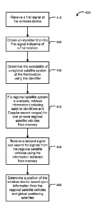
[0047] Fig. 4 is a flowchart showing an exemplary position location method 400
for a
wireless device. Position location method 400 can be performed by a processor
such as
processor 240 and/or position location processor 270. At block 410, a first
signal is
received at the wireless device. In some embodiments, the first signal is a
terrestrial
signal having an identifier indicative of a geographic location. The
identifier can serve,
for example, as a rough indicator of the area in which the wireless device is
located.
[0048] At block 420, the identifier is obtained from the first signal.
Thereafter, at
block 430, the identifier is used to determine the availability of a regional
satellite
system at the first location. This may involve, for example, determining
whether the
first location is within the coverage area of one or more regional satellite
systems such
as WAAS, EGNOS, MSAS, and QZSS. If the first location is within the coverage
area
of one or more regional satellite systems, information about the specific
satellite
vehicles is retrieved. At block 440, a satellite identifier and Doppler search
range for
regional satellite vehicles determined to be available at the first location
are retrieved
from a memory or other storage accessible to the wireless device. In some
CA 02726515 2010-11-30
WO 2010/005778 PCT/US2009/048273
embodiments, information about the regional satellites is maintained in a non-
volatile
memory of the wireless device.
[0049] At block 450, a second signal including signals from one or more
satellite
vehicles is received at a satellite receiver, and a search is performed for
regional satellite
5 vehicles using the information retrieved from the memory. The search can
include
generating reference signals at the wireless device using PRN codes for the
particular
regional satellite vehicles and cross-correlating the reference signals with
signals
obtained from a satellite receiver to obtain position information. The Doppler
search
range can limit the frequencies that are searched with the reference signals.
In this way,
10 a targeted search for those regional satellite vehicles serving the first
location is
performed and the search space is determined according to the first location.
In
addition, the location-based search for regional satellites can be performed
in parallel
with a search for global positioning satellites to further improve search
performance.
[0050] At block 460, a position of the wireless device is determined using
information
15 obtained from the satellite signals. For example, the position may be
determined
according to well known techniques in which correlation is used to determine
code
phases of the received signals for a plurality of satellite vehicles, and the
code phases
are used to determine distances between the satellites and the receiver, which
in turn can
be used to determine position. In some instances, such as with the QZSS
system,
regional satellite vehicles alone may provide sufficient positioning data to
get a position
fix for the wireless device. In other cases, regional satellite vehicles may
supply only
correction data with which to supplement positioning information obtained from
global
satellite vehicles. In some embodiments, one or more satellite signals may be
used in
conjunction with additional information to obtain the position of the wireless
device; for
example, time of flight or round trip delay information for terrestrial
sources may be
used with satellite signals for position determination.
[0051] The various illustrative logical blocks, modules, and circuits
described in
connection with the embodiments disclosed herein may be implemented or
performed
with a general purpose processor, a digital signal processor (DSP), a Reduced
Instruction Set Computer (RISC) processor, an application specific integrated
circuit
(ASICS), a field programmable gate array (FPGA) or other programmable logic
device,
discrete gate or transistor logic, discrete hardware components, or any
combination
CA 02726515 2010-11-30
WO 2010/005778 PCT/US2009/048273
16
thereof designed to perform the functions described herein. A general purpose
processor may be a microprocessor, but in the alternative, the processor may
be any
processor, controller, microcontroller, or state machine. A processor may also
be
implemented as a combination of computing devices, for example, a combination
of a
DSP and a microprocessor, a plurality of microprocessors, one or more
microprocessors
in conjunction with a DSP core, or any other such configuration.
[0052] A software module may reside in RAM memory, flash memory, non-volatile
memory, ROM memory, EPROM memory, EPROM memory, registers, hard disk, a
removable disk, a CD-ROM, or any other form of storage medium known in the
art. An
exemplary storage medium is coupled to the processor such that the processor
can read
information from, and write information to, the storage medium. In the
alternative, the
storage medium may be integral to the processor.
[0053] The steps of a method, process, or algorithm described in connection
with the
embodiments disclosed herein may be embodied directly in hardware, in a
software
module executed by a processor, or in a combination of the two. The various
steps or
acts in a method or process may be performed in the order shown, or may be
performed
in another order. Additionally, one or more process or method steps may be
omitted or
one or more process or method steps may be added to the methods and processes.
An
additional step, block, or action may be added in the beginning, end, or
intervening
existing elements of the methods and processes.
[0054] The above description of the disclosed embodiments is provided to
enable any
person of ordinary skill in the art to make or use the disclosure. Various
modifications
to these embodiments will be readily apparent to those of ordinary skill in
the art, and
the generic principles defined herein may be applied to other embodiments
without
departing from the spirit or scope of the disclosure. Thus, the disclosure is
not intended
to be limited to the embodiments shown herein but is to be accorded the widest
scope
consistent with the principles and novel features disclosed herein.