Note: Descriptions are shown in the official language in which they were submitted.
CA 02727616 2010-12-10
WO 2009/151835 PCT/US2009/043121
1
Magnetic Ranging And Controlled Earth Borehole Drilling
Field Of The Invention
This invention relates to systems and methods for magnetic ranging
between earth boreholes, and for controlled drilling of an earth borehole in a
determined spatial relationship with respect to another existing earth
borehole.
Background Of The Invention
In the quest for hydrocarbons, the need can arise for drilling of an earth
borehole in a determined spatial relationship with respect to another existing
borehole. One example is the so-called steam-assisted gravity drainage
("SAGD") process which is used to enhance production from an existing section
of a generally horizontal production weilbore in a reservoir of high viscosity
low-
mobility crude oil. A second weilbore, to be used for steam injection, is
drilled
above and in alignment with the production weilbore. The injection of steam in
the second weilbore causes heated oil to flow toward the production well, and
can greatly increase recovery from the reservoir. However, for the technique
to
work efficiently, the two boreholes should be in good alignment at a favorable
spacing over the length of the production region.
Referring to Figure 1, a pair of SAGD wells 10 and 20 are shown in the
process of being constructed. The lower well is drilled first and then
completed
SUBSTITUTE SHEET (RULE 26)
CA 02727616 2010-12-10
WO 2009/151835 PCT/US2009/043121
2
with a slotted liner in the horizontal section. The lower well 10 is the
producer
well and is located with respect to the geology of the heavy oil zone.
Typically,
the producer well is placed near the bottom of the heavy oil zone. The second
well 20 is then drilled above the first well, and is used to inject steam into
the
heavy oil formation. The second, injector well is drilled so as to maintain a
constant distance above the producer well throughout the horizontal section.
Typically, SAGD wells are drilled in Canada to maintain a vertical distance of
5 1
meters above the horizontal section, and remain within 1 meters of the
vertical
plane defined by the axis of the producer well. The length of the horizontal
section can typically vary from approximately 500 meters to 1500 meters in
length- Maintaining the injector well precisely above the producer well and in
the
same vertical plane is beyond the capability of conventional MWD direction and
inclination measurements.
Instead, magnetic ranging is typically used to determine the distance
between the two wells and their relative position. In US patent 5,485,088, a
magnetic ranging method is described where a solenoid is placed in one well
and
energized with current to produce a magnetic field. This solenoid (e.g. 12 in
Figure 1, which also depicts magnetic field B) comprises a long magnetic core
wrapped with many turns of wire. The magnetic field from the solenoid has a
known strength and produces a known field pattern that can be measured in the
other well, for example by a 3-axis magnetometer (represented at 21 in Figure
1)
mounted in a measurement while drilling (MWD) tool. The solenoid must remain
relatively close to the MWD tool for the magnetic ranging. The solenoid is
SUBSTITUTE SHEET (RULE 26)
CA 02727616 2010-12-10
WO 2009/151835 PCT/US2009/043121
3
pushed along the horizontal section of the well using a wireline tractor (e.g.
14 in
Figure 1), or coiled tubing, or it can be pumped down inside tubing (not
shown).
In a typical sequence of operations, the bottom hole assembly (BHA) in
the second well drills ahead a distance of 10m to 90m, corresponding to one to
three lengths of drill pipe. The distance between measurements depends on the
driller's ability to keep the well straight and on course. The drilling
operation
must be halted to perform the magnetic ranging operation. US patent 5,485,089
teaches that first, the 3-axis magnetometers in the MWD tool measure the
(50,000 nTesla) Earth's magnetic field with the current in the solenoid off.
Then
the solenoid is activated with DC current to produce a magnetic field which
adds
to the Earth's magnetic field. A third measurement is made with the DC current
in the solenoid reversed. The multiple measurements are made to subtract the
Earth's large magnetic field from the data obtained with the solenoid on.
The solenoid is then moved to a second position along the completed
welibore by a tractor or by other means. If the first position is slightly in
front of
the MWD magnetometer (i.e. closer to the toe of the well), then the other
position
should be somewhat behind the MWD magnetometer (i.e. closer to the heel of
the well). The solenoid is again activated with DC current, and the MWD
magnetometers make the fourth measurement of the magnetic field with DC
current. The DC current in the solenoid is.then reversed, and a fifth
measurement is made. The five magnetic field measurements are transmitted to
the surface where they are processed to determine the position of the MWD tool
magnetometers with respect to the position of the solenoid.
SUBSTITUTE SHEET (RULE 26)
CA 02727616 2010-12-10
WO 2009/151835 PCT/US2009/043121
4
There are drawbacks to this process. First, the solenoid must be
physically moved between the two borehole positions, during which time the BHA
is not drilling. This movement requires that the tractor be activated and
driven
along the wellbore, which is time consuming. Second, any errors in measuring
the two axial positions of the solenoid, or errors in the distance the
solenoid
moves, introduce errors in the calculated distance between the two wells.
Third,
since the solenoid is driven from one position to another, the distance the
solenoid travels may vary from one magnetic ranging operation to the next.
Since the MWD tool does not know how far the solenoid moved, it cannot
compute the distance to the first well. This means that all five magnetic
field
measurements must be transmitted to the surface via the typically slow MWD
telemetry system. Only after the MWD measurements have been decoded at the
surface and the appropriate algorithms processed (including knowledge of the
two solenoid positions), can the distance between the two wells be determined
and drilling resumed. Hence, this magnetic ranging process results in excess
rig
time and thus increases the cost of drilling the well.
Reference can also be made to U.S. Patents 3,731,752, 4,710,708,
5,923,170 and Re. 36,569, and also to Grills et al, "Magnetic Ranging
Technologies for Drilling Steam Assisted Gravity Drainage Wells Pairs and
Unique Well Geometries" SPE 79005, 2002, and to "Kuckes et al., New
Electromagnetic Surveying/Ranging Method for Drilling Parallel, Horizontal
Twin
Wells," SPE 27466, 1996.
SUBSTITUTE SHEET (RULE 26)
CA 02727616 2010-12-10
WO 2009/151835 PCT/US2009/043121
It is among the objects of the present invention to provide improved
magnetic ranging and improved distance and direction determination between
wellbores and to improve controlled drilling of an earth borehole in a
determined
spatial relationship with respect to another existing earth borehole.
SUBSTITUTE SHEET (RULE 26)
CA 02727616 2010-12-10
WO 2009/151835 PCT/US2009/043121
6
Summary Of The Invention
A form of the invention is directed to a method for determining the
distance and/or direction of a second earth borehole with respect to a first
earth
borehole, including the following steps: providing, in the first borehole,
first and
second spaced apart magnetic field sources; providing, in the second borehole,
a
magnetic field sensor subsystem for sensing directional magnetic field
components; activating the first and second magnetic field sources, and
producing respective first and second outputs of the magnetic field sensor
subsystem, the first output being responsive to the magnetic field produced by
the first magnetic field source, and the second output being responsive to the
magnetic field produced by the second magnetic field source; and determining
said distance and/or direction of the second earth borehole with respect to
the
first earth borehole as a function of said first output and said second
output.
In an embodiment of this form of the invention, the step of providing a
magnetic field sensor subsystem comprises providing a subsystem for sensing x,
y, and z orthogonal magnetic field components, the first output comprises
sensed
x, y and z magnetic field components responsive to the magnetic field produced
by the first magnetic field source, and the second output comprises sensed x,
y
and z magnetic field components responsive to the magnetic field produced by
the second magnetic field source. Also in this embodiment, the step of
activating
said first and second magnetic field sources comprises implementing AC
energizing of the magnetic field sources. The first and second magnetic field
sources can be activated sequentially, or can be activated simultaneously at
SUBSTITUTE SHEET (RULE 26)
CA 02727616 2010-12-10
WO 2009/151835 PCT/US2009/043121
7
different phases and/or frequencies. Also in this embodiment, the step of
providing first and second spaced apart magnetic field sources comprises
providing first and second solenoids on a common axis, and the common axis is
substantially parallel to the axis of said first borehole.
In another embodiment of the described form of the invention, there is
further provided, in the first borehole, a third magnetic field source, and
the
activating step includes activating the third magnetic field source and
producing a
third output of the magnetic field sensor subsystem, the third output being
responsive to the magnetic field produced by the third magnetic field source.
In
this embodiment, the step of determining said distance andlor direction of the
second earth borehole with respect to the first earth borehole comprises
determining said distance and/or direction as a function of the first output,
the
second output, and the third output. Also in this embodiment, the step of
providing first, second and third magnetic field sources comprises providing
first,
second and third solenoids on a common axis. if desired, more than three
magnetic field sources can be employed.
In accordance with another form of the invention, a method is set forth
for drilling of a second earth borehole in a determined spatial relationship
to a
first borehole, including the following steps: (a) providing, in the first
borehole, a
plurality of spaced apart magnetic field sources; (b) providing, in the second
borehole, a directional drilling subsystem and a magnetic field sensor
subsystem
for sensing directional magnetic components; (c) activating a first and a
second
of said plurality of magnetic field sources, and producing respective first
and
SUBSTITUTE SHEET (RULE 26)
CA 02727616 2010-12-10
WO 2009/151835 PCT/US2009/043121
8
second outputs of the magnetic field sensor subsystem, the first output being
responsive to the magnetic field produced by the first magnetic field source,
and
the second output being responsive to the magnetic field produced by the
second
magnetic field source; (d) determining the distance and direction of the
second
earth borehole with respect to the first earth borehole as a function of the
first
output and the second output; (e) producing directional drilling control
signals as
a function of the determined distance and direction; and (f) applying the
directional drilling control signals to the directional drilling system to
implement a
directional drilling increment of the second borehole. An embodiment of this
form
the invention further includes: advancing, in the first borehole the plurality
of
spaced apart magnetic field sources; and repeating said steps (c) through (f)
to
implement a further directional drilling increment of the second borehole.
Also,
an embodiment of this form of the invention includes measuring direction,
inclination, and gravity tool face of the directional drilling subsystem, the
directional drilling control signals also being a function of the measured
direction,
inclination, and gravity tool face.
In accordance with a further form of the invention, a system is set forth for
monitoring the distance and/or direction of a second earth borehole with
respect
to a first earth borehole, including: a first subsystem movable through the
first
borehole, the first subsystem including a plurality of spaced apart magnetic
field
sources and an energizer module for activating at least a first and second of
the
magnetic field sources; and a second subsystem movable through the second
borehole, and including a magnetic field sensor for sensing directional
magnetic
SUBSTITUTE SHEET (RULE 26)
CA 02727616 2010-12-10
WO 2009/151835 PCT/US2009/043121
9
field components, the second subsystem being operative to produce a first
output
responsive to the magnetic field produced by the first magnetic field source
and a
second output responsive to the magnetic field produced by the second magnetic
field source. The distance and/or direction of the second borehole with
respect
to the first borehole are determinable from the first and second outputs. In
an
embodiment of this form of the invention, a downhole processor is provided
for determining said distance and/or direction as a function of the first and
second outputs,
Among the advantages of the invention are the following: (1) A knowledge
of the strength of the magnetic field sources is not required. This is
important
since the magnetic field sources may be located inside a steel casing which
can
have a high and variable magnetic permeability, which reduces the strength of
the magnetic field outside the casing. Since the relative magnetic
permeability of
the casing is generally not known, this introduces an unknown variation in the
magnetic field strength. However, the technique of the invention is not
affected
by the casing. (2) It is not necessary to move the downhole tool containing
the
two magnetic field sources during a measurement sequence. This reduces the
amount of rig time required to make a magnetic ranging survey. (3) It is not
necessary to actually know or to determine the position of the magnetometers
(e.g. an MWD magnetometer device) with respect to the z direction. (4) Since
the distance to the first well and the direction to the first well do not
depend on
the axial position of the magnetic field sources, the calculations can be
performed downhole, e.g. in the processor of an MWD tool, and only the results
SUBSTITUTE SHEET (RULE 26)
CA 02727616 2010-12-10
WO 2009/151835 PCT/US2009/043121
sent to the surface via MWD telemetry. (5) It is not necessary to determine
the
distance and direction from the MWD magnetometer to either of the magnetic
field sources. Rather, the distance and direction from the MWD magnetometer to
the first well are obtained. (6) It is not necessary to move the downhole tool
to a
known z position in order to determine the direction from the magnetometers to
the downhole tool. (7) With an AC drive for the magnetic field sources, it is
not
necessary to measure the magnetic field with positive DC current, and then to
re-
measure with negative DC current, to cancel Earth's magnetic field. This saves
whatever rig time would be necessary for making two separate measurements
and transmitting them to the surface.
Further features and advantages of the invention will become more readily
apparent from the following detailed description when taken in conjunction
with
the accompanying drawings.
SUBSTITUTE SHEET (RULE 26)
CA 02727616 2010-12-10
WO 2009/151835 PCT/US2009/043121
11
Brief Description Of The Drawinq
Figure 1 is a diagram illustrating a prior art technique for magnetic
ranging.
Figures 2A and 213, when placed one over another, illustrate equipment
which can be used in practicing embodiments of the invention.
Figures 3A and 3B show, respectively, a plan view, partially in block form,
and a cross sectional view of equipment that can be used in practicing
embodiments of the invention.
Figure 4 is a flow diagram showing steps of a method in accordance with
an embodiment of the invention.
Figure 5 illustrates the geometry for the two magnetic dipoles on a
borehole axis.
Figure 6 illustrates geometry useful in determining the direction between
wells.
Figure 7 shows graphs of magnetic field components measured at a
magnetometer for an example useful in understanding the invention.
Figure 8 shows inverted radial distance between the two wells for an
example illustrating operation of the invention.
Figure 9 shows inverted vertical distance between the two wells for an
example illustrating operation of the invention.
Figure 10 shows inverted horizontal offset between the two wells for an
example illustrating operation of the invention.
SUBSTITUTE SHEET (RULE 26)
CA 02727616 2010-12-10
WO 2009/151835 PCT/US2009/043121
12
Figure 11 shows inverted location of the MWD magnetometer along the --
direction for an example illustrating operation of the invention.
Figure 12 shows graphs of magnetic field components measured at a
magnetometer for another example useful in understanding the invention.
Figure 13 shows inverted radial distance between the two wells for
another example illustrating operation of the invention.
Figure 14 shows inverted vertical distance between the two wells for
another example illustrating operation of the invention.
Figure 15 shows inverted horizontal offset between the two wells for
another example illustrating operation of the invention.
Figure 16 shows Inverted location of the MWD magnetometer along the z
direction for another example illustrating operation of the invention.
Figure 17 shows graphs of magnetic field components measured at a
magnetometer for a further example useful in understanding the invention.
Figure 18 shows inverted radial distance between the two wells for a
further example illustrating operation of the invention.
Figure 19 shows inverted vertical distance between the two wells for a
further example illustrating operation of the invention.
Figure 20 shows inverted horizontal offset between the two wells for a
further example illustrating operation of the invention.
Figure 21 shows a location of the MWD magnetometer along the z
direction for a further example illustrating operation of the invention.
SUBSTITUTE SHEET (RULE 26)
CA 02727616 2010-12-10
WO 2009/151835 PCT/US2009/043121
13
Figure 22 shows a downhole tool with three solenoids, which can be used
in practicing embodiments of the invention.
Figure 23 shows operation of two solenoids in parallel or anti-parallel
mode, in accordance with an embodiment of the invention.
SUBSTITUTE SHEET (RULE 26)
CA 02727616 2010-12-10
WO 2009/151835 PCT/US2009/043121
14
petalled Description
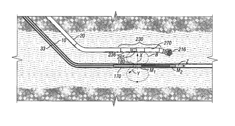
Figure 2A illustrates surface equipment of a type that can be used in
practicing embodiments of the invention. Wireline equipment 100 operates in
conjunction with the existing producer well 10 and drilling equipment 200
operates in conjunction with the well 20 being drilled and which, in this
example,
can ultimately be used as a steam injector well.
The wireline equipment includes cable 33, the length of which
substantially determines the relative depth of the downhole equipment. The
length of cable 33 is controlled by suitable means at the surface such as a
drum
and winch mechanism. The depth of the downhole equipment within the well
bore can be measured by encoders in an associated sheave wheel, the double-
headed arrow 105 representing communication of the depth level information and
other signals to and/or from the surface equipment. Surface equipment,
represented at 107, can be of conventional type, and can include a processor
subsystem 110 and a recorder, and communicates with the downhole equipment.
In the present embodiment, the processor 110 in surface equipment 107
communicates with a processor 248, which is associated with the drilling
equipment. This is represented by double-headed arrow 109. It will be
understood that the processors may comprise a shared processor, or that one or
more further processors can be provided and coupled with the described
processors.
The drilling equipment 200, which includes known measurement while
drilling (MWD) capability, includes a platform and derrick 210 which are
SUBSTITUTE SHEET (RULE 26)
CA 02727616 2010-12-10
WO 2009/151835 PCT/US2009/043121
positioned over the borehole 20. A drill string 214 is suspended within the
borehole and includes a bottom hole assembly which will be described further.
The drill string is rotated by a rotating table 218 (energized by means not
shown)
which engages a Kelly 220 at the upper end of the drill string. The drill
string is
suspended from a hook 222 attached to a traveling block (not shown). The Kelly
is connected to the hook through a rotary swivel 224 which permits rotation of
the
drill string relative to the hook. Alternatively, the drill string 214 may be
rotated
from the surface by a "top drive" type of drilling rig.
Drilling fluid or mud 226 is contained in a mud pit 228 adjacent to the
derrick 210. A pump 230 pumps the drilling fluid into the drill string via a
port in
the swivel 224 to flow downward (as indicated by the flow arrow 232) through
the
center of drill string 214. The drilling fluid exits the drill string via
ports in the drill
bit and then circulates upward in the annulus between the outside of the drill
string and the periphery of the borehole, as indicated by the flow arrows 234.
The drilling fluid thereby lubricates the bit and carries formation cuttings
to the
surface of the earth. At the surface, the drilling fluid is returned to the
mud pit
228 for recirculation. In the present embodiment, as will be described, a well
known directional drilling assembly, with a steerable motor, is employed.
As shown in Figure 2B, which shows downhole portions of wells 10 and
20, mounted near the drill bit 216, is a bottom hole assembly 230, which
conventionally includes, inter alia, MWD subsystems, represented generally at
236, for making measurements, and processing and storing information. One of
these subsystems, also includes a telemetry subsystem for data and control
SUBSTITUTE SHEET (RULE 26)
CA 02727616 2010-12-10
WO 2009/151835 PCT/US2009/043121
16
communication with the earth's surface. Such apparatus may be of any suitable
type, e.g., a mud pulse (pressure or acoustic) telemetry system, wired drill
pipe,
etc., which receives output signals from the data measuring sensors and
transmits encoded signals representative of such outputs to the surface (see
Figure 2A) where the signals are detected, decoded in a receiver subsystem
246,
and applied to a processor 248 and/or a recorder 250. The processor 248, and
other processors, may comprise, for example, suitably programmed general or
special purpose processors. A surface transmitter subsystem 252 is provided
for
establishing downward communication with the bottom hole assembly by any
known technique, such as mud pulse control (as represented by line 252A),
wired drill pipe, etc.
The subsystems 238 of the bottom hole assembly also include
conventional acquisition and processing electronics (not separately shown)
comprising a microprocessor system, with associated memory, clock and timing
circuitry. Power for the downhole electronics and motors may be provided by
battery and/or, as known in the art, by a downhole turbine generator powered
by
movement of the drilling fluid. A steerable motor 270 and under control from
the
surface via the downhole processor, is provided for directional drilling.
The bottom hole assembly subsystems 236 also include one or more
magnetometer arrays 265 which, in the present embodiment, preferably include
AC magnetometers, all under control of the downhole processor in the bottom
hole assembly, which communicates with the uphole processor(s) via the
described telemetry subsystem.
SUBSTITUTE SHEET (RULE 26)
CA 02727616 2010-12-10
WO 2009/151835 PCT/US2009/043121
17
In accordance with a feature of the invention, and as illustrated in Figure
2B, a pair of spaced apart magnetic field sources, denoted by magnetic dipole
sources M, and M2, are provided in a 1001 mounted on a tractor 170, moveable
under control of wireline cable 33. Coiled tubing or other motive means can
alternatively be used. In this embodiment, the magnetic dipole sources are
solenoids; that is, coils wound on respective magnetic cores. Energizing and
control is provided by downhole electronics, which can include a downhole
processor, represented in Figure 28 by block 180, which communicates with the
uphole electronics and processor via the wireline.
Figure 3 shows, in further detail, the solenoid M, and M2 mounted in
housing 190. As seen in Figure 3B, wire windings 191 are wound on a tubular
magnetic core 192, the central opening being useful for communicating wiring.
The power supply, control electronics, and downhole processor, are housed in
cartridge 180.
The solenoids M, and M2 are aligned with the borehole axis (z-direction)
and have a fixed separation d. The solenoids are contained in the non-
magnetic housing or non-metallic (e.g. fiberglass) housing 190. The distance
between the two solenoids may be set depending on the desired inter-well
spacing. For example, if the inter-well spacing is 5m, then the solenoids
should
preferably be spaced in the range of 5m to 10m. If the inter-well spacing is
greater, then a longer spacing is desirable. The solenoids' spacing can be
adjusted by inserting spacers or additional housings between them. The
downhole tool of the present embodiment is in the form of a wireline logging
tool,
SUBSTITUTE SHEET (RULE 26)
CA 02727616 2010-12-10
WO 2009/151835 PCT/US2009/043121
18
and electronic cartridge 180 thereof is provided with a capability of
producing low
frequency AC currents for the solenoids.
As above indicated, the MWD tool in well 20 preferably contains at least
one 3-axis magnetometer capable of measuring an AC magnetic field, so that the
solenoids of the wireline tool can be driven by an AC current, rather than by
a DC
current. The advantage is that the Earth's DC magnetic field can be entirely
suppressed, and this is achieved in the present embodiment by coupling high
pass filters with the magnetometer outputs. Since the 50,000 nTesla Earth's
magnetic field is no longer present in the data, much weaker magnetic fields
can
be accurately measured than is possible for DC magnetic fields. This also can
reduce the weight and power requirements for the solenoids and can increase
the range between wells.
Preferably, the frequency of the AC current should generally lie in the
range of 1 Hz to 20 Hz; a suitable choice being a frequency of approximately 3
Hz. For frequencies much greater than 20 Hz, the magnetic field may be unduly
attenuated if the first well has steel casing, or by drill collar material in
the MWD
tool when the 3-axis magnetometer is located inside the drill collar. The
techniques hereof can also be implemented using DC magnetic fields, albeit
less
conveniently.
A flow diagram for a sequence of magnetic ranging and drilling is shown in
Figure 4. As represented by block 405, while drilling a stand of pipe (e.g.10m
to
30m), the downhole tool is moved so that this operation does not consume rig
time. The downhole tool is moved to be approximately opposite the MWD tool
SUBSTITUTE SHEET (RULE 26)
CA 02727616 2010-12-10
WO 2009/151835 PCT/US2009/043121
19
magnetometers when the current stand of drill pipe has been drilled- However,
it
is not necessary to exactly position the downhole tool. When the "Kelly is
down",
drilling stops and the BHA is not rotating (block 410), a standard MWD survey
is
performed (block 420) to obtain direction, inclination, and gravity tool face.
This
data can be transmitted to the surface via MWD telemetry, e.g. by mud pulse or
electromagnetic telemetry. Then, the first solenoid in the downhole tool is
activated (block 425), preferably by an AC current in the range of 1 to 10 Hz.
The resulting AC magnetic field is measured by 3-axis MWD magnetometers and
stored in downhole memory. Then, as represented by block 430, the first
solenoid is turned off and the second solenoid is activated. Its AC magnetic
field
is measured by the same 3-axis MWD magnetometers and stored in downhole
memory. As described further hereinbelow, the radial distance between the two
wells and the direction from one well to the other can be computed downhole
(block 440) and then transmitted to the surface (block 450). The time required
to
transmit the radial distance and direction is much less than transmitting the
raw
data to the surface, so that drilling can commence (block 460) immediately.
The
directional drilling is performed in accordance with the received distance and
direction information, to maintain the desired alignment and distance of the
second well 20 with respect to the first well 10. The next cycle can then be
performed to implement the next drilling increment. It will be understood that
simultaneous activation of the magnetic field sources, such as at different
phases
and/or frequencies, with suitable selective filtering of the magnetometer
outputs,
can alternatively be utilized.
SUBSTITUTE SHEET (RULE 26)
CA 02727616 2010-12-10
WO 2009/151835 PCT/US2009/043121
Among the objects hereof are to determine the radial distance from the
MWD magnetometer in the second well to the borehole axis of the first well and
to determine the direction from the MWD magnetometer in the second well to the
first well. Referring to Figure 5, let Mi and M2 be two magnetic dipole
sources
(in this case, solenoids) that are located along the borehole axis of the
first well.
Ml is located at (x1,y1,z1)=(0,0,0), and M2 is located at (x2,y2,z2)=(0,0,d),
where d is the known separation between the two magnetic dipoles. Consider
the point (x3, y3,z3) located a radial distance r = R+Y3 from the z -axis,
where r = x3 x+ 73 y , and where the angle 0 between x and x is given by
tan 0 =. In general, the best results are obtained when 0<_ z3 <_ d, although
x3
this condition is not a necessity.
For simplicity, the solenoids will be represented mathematically as point
magnetic dipoles that are aligned with the borehole direction. That is,
M1= M1 z and M2 = M2 Z, where z is the unit vector pointing along the axis of
the first well. The presence of a steel casing or steel liner may perturb the
shape
of the magnetic field, but this can be taken into account with a slight
refinement
of the model. The primary effect of the casing is to attenuate the strength of
the
magnetic field.
Now, consider the situation where the first magnetic dipole Mi is
activated and the second magnetic dipole is off, i.e. M2 = 0. In general, the
SUBSTITUTE SHEET (RULE 26)
CA 02727616 2010-12-10
WO 2009/151835 PCT/US2009/043121
21
magnetic field at (x3, y3,z3) will have field components along the three
directions, X, Y, and z, such that
Bl(x3,y3,z3)=BlX(x3,y3,z3)x+Bl,,(x3,y3,z3)y+Blz(x3,y3,z3)z. All three
magnetic field components are measured by the 3-axis MWD magnetometer.
The three magnetometer axes may not coincide with x, y, and z directions,
but it is a simple matter to rotate the three magnetometer readings to the x,
y ,
and z directions based on the MWD survey data.
Referring to Figure 6, the magnetic field along the radial r direction is
n Il A
Blr(x3, y3, z3) = Blr(x3, 73,23 )r = Blx(x3, y3,z3)x+Bly(x3, y3, z,)7, and the
B
direction of Blr(x3, y3,z3) is given by tan9l = Here-after, (x3,73,23) will
B lx
be suppressed, e.g. B1), =Bly(x3, y3,z3). Hence, the ratio of the two measured
magnetic field components B1, and Blx can be used to determine the direction
from the observation point (x3, y3,z3) to a point on the axis of the first
well at
(0,0,z3). Note that there can be an ambiguity in the arctangent of 180 . In
most
circumstances, such as SAGD, the general direction to the first well is
sufficiently
well known (i.e. down in the case of SAGD) so the 180 ambiguity does not
enter.
The magnetic field at the MWD magnetometer with Ml activated is given
by
SUBSTITUTE SHEET (RULE 26)
CA 02727616 2010-12-10
WO 2009/151835 PCT/US2009/043121
22
2
B =L3M I5-'1r-3 1+ z3 and
Ir 4. 1 r r
5
2 2
B= Lo M [2(-z3 -1 -3 [1+(z3
lz 4n I r r
Note that Blr -a 0 as z3 - 0, hence BI x - 0 and B1Y -~ 0. This means that it
is difficult to determine the angle 91= arc tan Biy directly across from the
first
Ix
solenoid.
z B 11 Define the quantities u = z3 = z3 and a= = 2u -1, where a
r JX+y 3 BIr 3u
is obtained from the measured magnetic field components. Solving the quadratic
equation yields u = 3a 9a2 +8 4 where the + sign is used if z3 > 0 and the
sign is used if z3 < 0.
In the next step, Mi is deactivated, i.e. Mi = 0, and M2 is activated.
The magnetic field at the MWD magnetometer is now B2 = B2xx+B2, y+B2zz .
The radial magnetic field can be written as B2r =B2rr=B2xx+B2yy, and the
angle 02 obtained from tan02 = B2y
B2x
The magnetic field at the MWD magnetometer due to M2 is
SUBSTITUTE SHEET (RULE 26)
CA 02727616 2010-12-10
WO 2009/151835 PCT/US2009/043121
23
2
B2 = 3M2 z3r d r-3 + z3 - d and
4,, r
5
2
B M 2(!!:-d )_1].r_3 1+ z3-d2 ,
zz 4N 2 r 1.
z B
Define the quantities v s-d r - z3 z -d and p . z 23v2v-1 where p is
x3 + 73 zr
known from the measured magnetic field components. Solving the quadratic
equation yields v = 3p 5a +$ , 4 where the + sign is used if z3 > d and the -
sign is used if z3 < d.
The quantities u and v are now known from MWD magnetometer data.
From z =1r = u = d + r = v, one obtains the desired radial distance from the
MWD
magnetometer to the axis of first well, r = d
u-v
Note that it is not necessary to know any of the axial positions (zl, z2 , or
z3) to compute the radial distance between the two wells. The only information
required is the known spacing between the two solenoids, d = z2 -z1. However,
if it is desired, the axial position of the MWD magnetometer can be computed
from z3 = 'd
u-v
SUBSTITUTE SHEET (RULE 26)
CA 02727616 2010-12-10
WO 2009/151835 PCT/US2009/043121
24
Then, the direction from the MWD magnetometer to the first well axis is
determined by 0 =tan-' (131 = 2 (e +02) , with the caveat that the angle can
be
s
noisy opposite a solenoid. In this case, it is better to use the magnetic
fields from
the more distant solenoid. For SAGD wells, the vertical distance between the
two wells is given by x3 = r cos 0 and the horizontal offset between the two
wells
is given by y3 = rsin0.
As described in further detail below, a downhole tool can contain three (or
more) solenoids spaced along its length. The processing described above could,
for example, be performed with pairs of solenoids to determine the radial
distance between the two well bores and the direction from one to the other.
As first described above in conjunction with Figure 3, the solenoids can be
constructed with a magnetic core (e.g. mu-metal) and multiple turns of wire.
Typical dimensions for the core can be an outer diameter of 7 cm, and a core
length between 2m and 4m. As seen in Figure 3, the magnetic core can have a
central hole to allow wires to pass though. In an embodiment hereof, several
thousand turns of solid magnetic wire (e.g. #28 gauge) are wrapped over the
core and the entire assembly is enclosed in a fiberglass housing. If the
downhole
tool is to be subjected to high pressures, then the inside of the fiberglass
housing
can be filled with oil to balance external pressures. If the pressures are
less than
a few thousand psi, then the housing can be permanently filled with epoxy
resin.
In one embodiment, the outer diameter of the fiberglass housing is
approximately
cm.
SUBSTITUTE SHEET (RULE 26)
CA 02727616 2010-12-10
WO 2009/151835 PCT/US2009/043121
The magnetic dipole moment is given by M = NI Ate. where N is the
number of wire turns, I is the current, and A,,F is the effective area which
includes the amplification provided by the magnetic core. Experiments show
that
such a solenoid can produce a magnetic moment in air of several thousand amp-
meter2 at modest power levels (tens of watts). However, the magnetic dipole
moment can be attenuated by 20dB or more in a cased well. The amount of
attenuation depends on the casing properties and on the frequency. The
attenuation increases rapidly above about 20 Hz, so a desirable frequency
range
is 10 Hz and below. Experiments in casing indicate that an effective magnetic
dipole moment on the order of a few hundred amp-rneter2 can be achieved with
casing present.
To calculate the signal-noise ratio for an embodiment hereof, it is
assumed that a precision of 0.1 nTesla can be achieved on each magnetometer
axis with an AC magnetic field of a few Hertz.
Example #1. SAGD wells at 5m separation
In this example, the two solenoids are separated by a distance d =10 m
and each solenoid has a magnetic dipole moment of M = 100 amp-meter2. A
SAGD injector well is to be drilled 5m above the producer well. It is assumed
that the MWD magnetometer is located at (x3,y3, z3) = (5m,1m,z3), various
quantities are plotted as a function of z`3. The magnetic field components
measured at the magnetometer (Bir , Btz, B2, r, and B2z) are shown in Figure
7.
SUBSTITUTE SHEET (RULE 26)
CA 02727616 2010-12-10
WO 2009/151835 PCT/US2009/043121
26
Noise with a standard deviation of 0.1 nTesla noise has been added to field
components: Bix, Bid, , Btu, B2x, B23,, and B2,. Note that the magnetic field
is strongest over the range z3 =--5m to z3 =+15m. In Figures 8 to 11, the
axial
position of the MWD magnetometer (z3) is incremented in Im steps while
inverting for r, x3, y3, and z3, respectively. The average results and
standard
deviations are also tabulated in Table 1 for two ranges: z3 a [0.5m,9.5m] and
z3 E[-5.5m,15.5m]. The difference between the inverted value for z3 and the
actual value for z3 is given (Oz3 ). The results are best when 0:5 z3 <d , and
still
favorable when -5:5 z3 s d + 5. These results are well within the tolerances
needed for drilling a SAGD well.
Table 1: Inverted parameters for example #1. The average value and the
standard deviation are given for each range of z3.
r (m) x3 (m) y3 (m) Ix3 (m)
Actual values 5.10 5.00 1.00 0.00
Inverted values for
5.13 0.01 5.04 0.01 1.00 0.03 0.00 0.01
z3 Ã [0.5m, 9.5ni]
Inverted values for
5.30 0.12 5.20 0.14 1.04 0.08 -0.08 0.32
z3 E [-5.5m,15.5m]
Example #2... $AGD wells at 10m separation
SUBSTITUTE SHEET (RULE 26)
CA 02727616 2010-12-10
WO 2009/151835 PCT/US2009/043121
27
In this example, the two solenoids are again separated by a distance
d = 10 m and each solenoid has a magnetic dipole moment of M =100 amp-
meter2. A SAGO injector well is to be drilled 10m above the producer well. It
is
assumed that the MWD magnetometer is located at (x3,y3,z3) = (10m,lm, z3),
various quantities are plotted as a function of z3. The magnetic field
components measured at the magnetometer are shown in Figure 12. Noise with
a standard deviation of 0.1 nTesla noise has been added to all field
components.
In Figures 13 to 16, the axial position of the MWO magnetometer (z3) is varied
in
1 m steps while inverting for r , x3, y3, and z3, respectively. The average
results and standard deviations are also tabulated in Table 2 for two ranges:
z3 a [0.5m,9.5m] and z3 c- [-5.5m,15.5m] . The results are still good for 0<_
z3 s d,
and still quite useful for -5s za s d + 5.
Table 2: Inverted parameters for example #2. The average value and the
standard deviation are given for each range of zs
r (m) x3 (m) y3 (m) Az3 (m)
Actual values 10.05 10.00 1.00 0.00
Inverted values for
10.23 0.10 10.19 0.08 0.91 0.24 0.01 0.03
z3 e[0.5m,9.5m]
Inverted values for
10.31 0.46 10.26 0.47 1.04 0.06 -0.14 0.17
z3 E [--5.5m,15.5m]
SUBSTITUTE SHEET (RULE 26)
CA 02727616 2010-12-10
WO 2009/151835 PCT/US2009/043121
28
Example #3. SAGD wells at 15m separation
In this case, it is advantageous to separate the two solenoids to d = 15 m
and to increase the magnetic dipole moment to M = 200 amp-meter2. It is
assumed that the MWD magnetometer is located at (x3, y3, z3) _ (15m,1m, z3) ,
and various quantities are plotted as a function of z3. The magnetic field
components measured at the magnetometer are shown in Figure 17. Noise with
a standard deviation of 0.1 nTesla noise has been added to all field
components.
In Figures 18 to 21, the axial position of the MWD magnetometer (z3) is varied
in
1 m steps while inverting for r, x3, 73, and z3, respectively. The average
results and standard deviations are also tabulated in Table 3 for two ranges.
z3 e [0.5m,14.5m] and z3 a [-5.5m,20.5m] . The results provide an accuracy
better than I m in all conditions, even with a potential uncertainty in z3 of
13m.
Table 3: Inverted parameters for example #3. The average value and the
standard deviation are given for each range of z3.
r (m) x3 (m) y3 (m) tz3 (m)
Actual values 15.03 15.00 1.00 0.00
Inverted values for
15.11 0.40 14.93 0.20 0.9110.86 0.04 0.05
z3 a [O.5m,14.5m]
Inverted values for
15.64 0.43 15.62 0.67 0.43 0.45 0.03 0.17
z3 a [-5,5m, 20.5m]
SUBSTITUTE SHEET (RULE 26)
CA 02727616 2010-12-10
WO 2009/151835 PCT/US2009/043121
29
If the first well is an open hole and the downhole tool can be safely run into
the
borehole, then a much greater range between the two wells can be
accommodated because much stronger magnetic dipole moments are possible.
Alternatively, if the noise in the MWD magnetometers can be reduced below 0.1
nTesla, then a greater range is also possible. This may be accomplished by
averaging the signals over a longer time interval.
As above noted, more than two solenoids can be deployed in the
downhole tool. For example, Figure 22 displays a downhole tool with three
solenoids, labeled Ml, M2, and M3, where M1 is located at z = 0 , M2 is
located at z = d1, and M3 is located at z = d1 + d2 . The three solenoids can
be
activated sequentially in time to produce three corresponding magnetic fields
measured at (x3, y3,z3) . The three magnetic field readings are composed of
n A A A
radial and axial components: B1=B1rr+Blaz, B2 = B2rr+B2az, and
z B 2u2-1 z -d
B3=Barr+B3zz. Define u--, a iZ = , v- 3 1 and
r B1r 3u r
z3 -d-d2
,t? = B z - z 1 as before. In addition, define w = r and
2r
~ = 2w2 -1
y . Since a, /3 , and y are measured quantities, the three
B 3r 3w
9~3~ +8
quadratic equations can be solved yielding u = 3a 9 a2+8 , v = 3P 9
4 4
i
and w = 3y 97 +8 . The radial distance can be computed from any two pairs
SUBSTITUTE SHEET (RULE 26)
CA 02727616 2010-12-10
WO 2009/151835 PCT/US2009/043121
of observations. If the measurements from solenoids Mi and M2 are used,
then r=- di and z3 = 1d-1. If the measurements from solenoids Mi and M3
u-V u-v
are used, then r= dl and z3 = u(d1 +d 2) Finally, if the measurements
u-w u-w
from solenoids M2 and M3 are used, then r d2 and z3 = v d2 + di .
Y-W Y-W
The potential advantages of using three solenoids include the following.
First, there is a greater axial range over which the inversion is accurate
because
the array is longer. The radial distance can be estimated from the nearest
pair of
solenoids (e.g. from the pair M1+M2 or from the pair M2+.M'3). Second, the
accuracy also can be improved by averaging the results from different pairs of
solenoids (e.g. from the pair Mi+M2 and from the pair M2+M3 ). Third, if the
radial distance is much greater than dl or d2, then the most accurate estimate
may be given by the pair Mi +M3. Similarly, arrays with more than three
solenoids can be deployed.
Another embodiment of the invention is illustrated in Figure 23. The two
solenoids M, and M2 can be driven sequentially in time as previously
described,
or they can be driven simultaneously in parallel mode and simultaneously in
anti-
parallel mode. A double pole double throw (DPDT) switch 2311 is used in this
embodiment to switch between parallel and anti-parallel modes. In parallel
mode, the currents in the two solenoids are in phase so that the two magnetic
dipole moments are parallel. In parallel mode, the magnetic field measured at
SUBSTITUTE SHEET (RULE 26)
CA 02727616 2010-12-10
WO 2009/151835 PCT/US2009/043121
31
(x3,y3,z3) is B~, =(Birt+Azz}+(B2rr+B2ZZ~. In anti-parallel mode, the
magnetic field measured at (x3,y3,z3) is B (+B12 )_(B ; + B2z;).
Hence, the magnetic fields from the individual solenoids can be obtained from
BlF x +B1Ez = ~(BP +B~~ and Berl +B,aZ = Then, the previous
analysis can be use to determine the radial distance from the z -axis.
As previously noted, yet another method for obtaining the magnetic fields
from the two solenoids is to drive them at two different frequencies. Let
solenoid
Ml be driven by a current at frequency f and let solenoid k2 driven by a
current at frequency f2 . Both solenoids can then be activated simultaneously.
The magnetic field measured by the magnetometer located at (x3, y3,z3) can be
decomposed into the two frequencies by Fourier transform or by other well
known signal processing methods. In this manner, the magnetic field
contributions from the individual solenoids can be separated, and the
previously
described processing applied to determine the distance and direction to the z -
axis.
SUBSTITUTE SHEET (RULE 26)